

ORH_wxman
-
Posts
93,092 -
Joined
-
Last visited
Content Type
Profiles
Blogs
Forums
American Weather
Media Demo
Store
Gallery
Everything posted by ORH_wxman
-
First Legit Storm Potential of the Season Upon Us
ORH_wxman replied to 40/70 Benchmark's topic in New England
I think you could easily pick up 1-2” provided the QPF is there on Saturday. -
First Legit Storm Potential of the Season Upon Us
ORH_wxman replied to 40/70 Benchmark's topic in New England
06z euro no real change from 00z….maybe ticked slightly better if you squint. -
First Legit Storm Potential of the Season Upon Us
ORH_wxman replied to 40/70 Benchmark's topic in New England
That 06z GFS was kind of spooky. Everything was trending great until that run. Hopefully we get a tick west here on 06z Euro. The skynet models (both GFS and Euro skynet) have kept ticking west though. Good sign there. -
First Legit Storm Potential of the Season Upon Us
ORH_wxman replied to 40/70 Benchmark's topic in New England
GEFS individual lows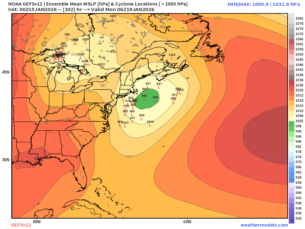
-
First Legit Storm Potential of the Season Upon Us
ORH_wxman replied to 40/70 Benchmark's topic in New England
Ukie was still mostly a miss. Scraper. But it was better than 12z. -
First Legit Storm Potential of the Season Upon Us
ORH_wxman replied to 40/70 Benchmark's topic in New England
That one was a slower mover but it’s possible this could have a similar longitude gradient in the snowfall. -
First Legit Storm Potential of the Season Upon Us
ORH_wxman replied to 40/70 Benchmark's topic in New England
Yeah prob warning snows for eastern half of SNE but western parts still get good advisory snows. -
First Legit Storm Potential of the Season Upon Us
ORH_wxman replied to 40/70 Benchmark's topic in New England
GGEM is a pretty big hit too for eastern zones. -
First Legit Storm Potential of the Season Upon Us
ORH_wxman replied to 40/70 Benchmark's topic in New England
I went to see a Garth Brooks concert that Saturday night and as we got into Boston, the backlash started and temps dropped like 10 degrees. Everything went from sloppy mess to frozen with 3” of powder on top. Was a really wintry scene in town that night. Of course, I was weenieing out the entire time during the concert checking the NAM, then the RGEM, etc as the 00z runs came in and that’s when they turned it into a monster HECS. The 12z runs had already gone into a moderate event. -
First Legit Storm Potential of the Season Upon Us
ORH_wxman replied to 40/70 Benchmark's topic in New England
The predecessor wave drops 1-3” Saturday PM across most of interior SNE/CNE -
First Legit Storm Potential of the Season Upon Us
ORH_wxman replied to 40/70 Benchmark's topic in New England
That was objectively a nice move. Need another one. -
First Legit Storm Potential of the Season Upon Us
ORH_wxman replied to 40/70 Benchmark's topic in New England
Man, too bad we can't lock in the entire run of 18z skynet Euro....winter of yore. -
First Legit Storm Potential of the Season Upon Us
ORH_wxman replied to 40/70 Benchmark's topic in New England
The low center ticked E but it was stronger with a larger QPF field, so the QPF looked slightly west. It's kind of what @Typhoon Tip was saying earlier about how the center can move slightly E but the impact of sensible wx can move slightly W if the storm is stronger/larger. Either way, we're talking error bars here....nothing big. -
First Legit Storm Potential of the Season Upon Us
ORH_wxman replied to 40/70 Benchmark's topic in New England
AI GFS bumped NW…OP did not. -
First Legit Storm Potential of the Season Upon Us
ORH_wxman replied to 40/70 Benchmark's topic in New England
You hope maybe we trend into a compromise of sorts and get at least something half-decent out of this. The 12z blizzard was a pipe dream given it had zero support. -
First Legit Storm Potential of the Season Upon Us
ORH_wxman replied to 40/70 Benchmark's topic in New England
Def less dynamic looking than 12z though. But should still be a good hit. -
First Legit Storm Potential of the Season Upon Us
ORH_wxman replied to 40/70 Benchmark's topic in New England
Yeah GFS Skynet still trending better a bit. OP looks a bit less amped than 12z but still prob gonna be a hit. -
First Legit Storm Potential of the Season Upon Us
ORH_wxman replied to 40/70 Benchmark's topic in New England
Looking more likely…esp outside SE areas. -
First Legit Storm Potential of the Season Upon Us
ORH_wxman replied to 40/70 Benchmark's topic in New England
No -
First Legit Storm Potential of the Season Upon Us
ORH_wxman replied to 40/70 Benchmark's topic in New England
There on all guidance but particularly noticeable on euro. -
First Legit Storm Potential of the Season Upon Us
ORH_wxman replied to 40/70 Benchmark's topic in New England
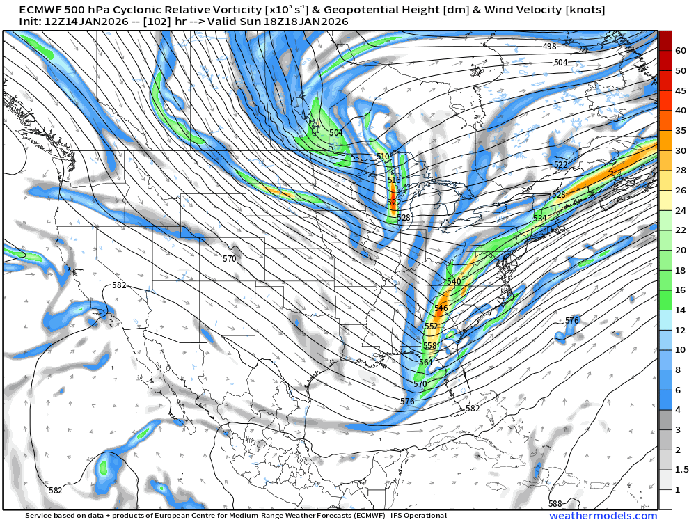
I do like the mean trough position on this look. We have two shortwaves and the kicker might be key here…we want it to dig to help raise the heights ahead of the first one. It will have some destructive interference, but a little bit of that is okay otherwise we’d be trying to rip this north into the Hudson valley. You can see all that vort energy string out ahead of the storm over New England on the op euro which is a problem…it’s preventing downstream ridging to allow this storm to gain latitude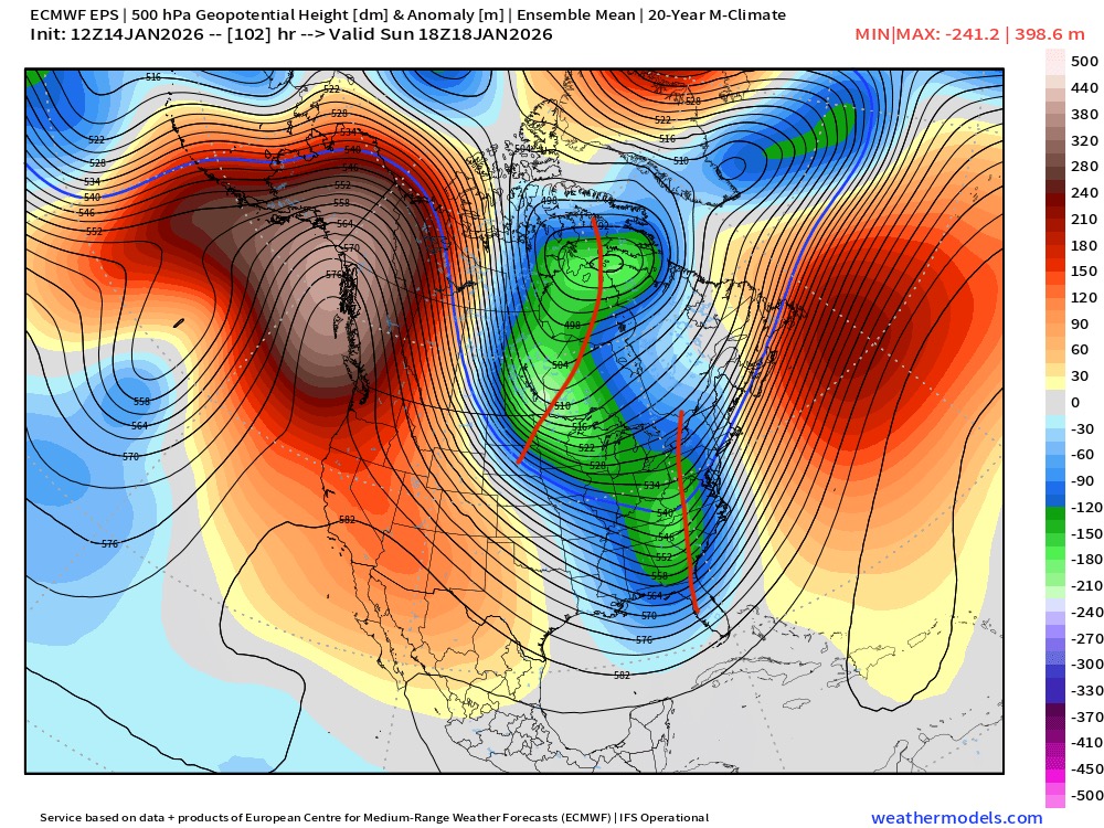
-
First Legit Storm Potential of the Season Upon Us
ORH_wxman replied to 40/70 Benchmark's topic in New England
EPS is a bit better than the OP….which isn’t a high bar obviously…but I’d rather that than the other way around. 1-2” for far SE areas it looks like while the OP was a complete whiff even for the cape. -
First Legit Storm Potential of the Season Upon Us
ORH_wxman replied to 40/70 Benchmark's topic in New England
I do like the AIs being more bullish on this. They wanted almost nothing to do with 1/15 which was kind of a red flag. I wouldn’t forecast solely on AI models, but if they are showing more support then that always helps. -
January 2026 regional war/obs/disco thread
ORH_wxman replied to Baroclinic Zone's topic in New England
Yeah the full description was “the crazy drunk uncle” but we all just shortened it to crazy uncle. Jerry def came up with the name at least 15 years ago…I think it was late 2000s winters. -
First Legit Storm Potential of the Season Upon Us
ORH_wxman replied to 40/70 Benchmark's topic in New England
I had already told Don that once the euro came out, we’d see the vibe shift sharply back in the opposite direction. Im not selling the threat fully just yet. But GFS is obviously an outlier. To be fair though, so is the Euro. Those are the two goalposts. Most guidance is in between those two.


