

ORH_wxman
-
Posts
93,092 -
Joined
-
Last visited
Content Type
Profiles
Blogs
Forums
American Weather
Media Demo
Store
Gallery
Everything posted by ORH_wxman
-
This is even more impressive. On the west side of the storm KMDJ 291150Z AUTO 02083G102KT M1/4SM FG BKN002 OVC019 26/26 A2858 RMK A01
-
KDLP 291135Z AUTO 09067G85KT 3/4SM BR SCT003 BKN014 BKN021 25/25 A2930 RMK A01
-
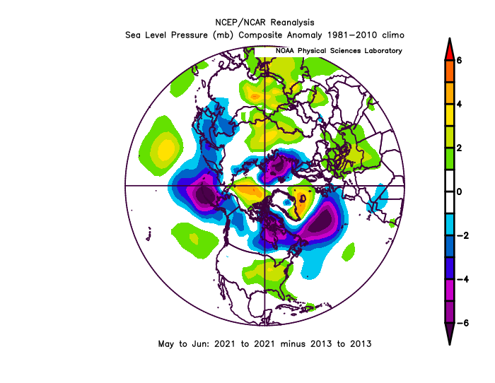
You can't get a meaningful ice recovery on the Siberian side without being able to hold the multi-year ice in the Beaufort first. The Beaufort Gyre circulates the ice up toward the Chukchi and East Siberian Sea, but if the MYI is melting out in the Beaufort during the summer, then it makes any type of longer term recovery impossible. As for the ice retention patterns......2013 was probably the best ice retention pattern we've seen in the past decade. If you subtract 2013 pressure anomalies from 2021 for the crucial pre-conditioning months of May/June, you can see how 2021 had higher pressures over the CAB (esp the PAC/Beaufort side) while having lower pressures over the Kara....a worse pattern than 2013.
-
I don't think we've reached the NSIDC area min....that would be like a week earlier than the previous earliest min. There is still plenty of low concentration ice in the Beaufort/Chukchi that should bring us down a bit further. That said, I don't expect a very big drop like 2010 had....the weather looks really cold up there on the models over the next week.
-
The Cleveland superstorm was a bust too...was originally going to be eastward and be a lot of snow up here.
-
Finally got a little gust that caused some damage
- 713 replies
-
- 11
-

-

-
This is really lame. Not much up on the hill here either for wind. It’s now or never for gusts....really between now and 3-4pm. We’re seeing temps/dews rise a bit into the low 70s so that may try to help the good 925 winds mix down, but the clock is ticking.
-
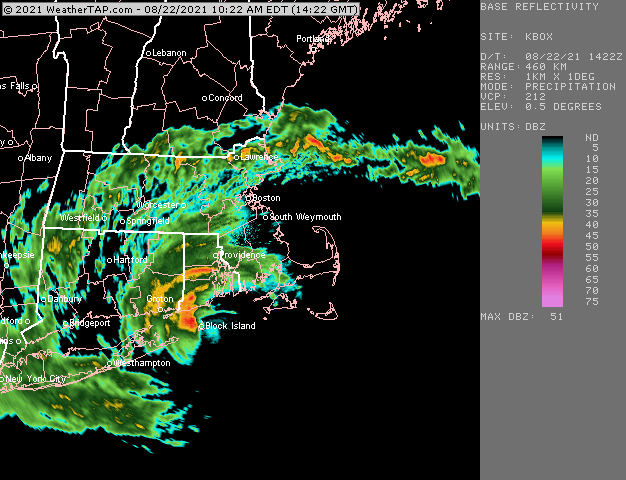
Hard to say, the center is kind of broad. It certainly came close enough to say it basically crossed BID.
-
Almost looks like there are two centers, lol...Looks like low level circulation there coming onshore east of WST and then another near GON
-
Looks like the center is just N of BID but still offshore the mainland.
-
Looks like BID might be getting grazed by the west side of the center.
-
Yeah 40-50 will bring down a decent number of limbs with the wet foliage all over them. A few trees being uprooted with the soggy ground are likely too. I'm just hoping to keep power, but the grid on this hill is about as good as the CT grid.
-
I'm thinking like 40-50mph gusts here. Best window looks like about noontime to 3ish. That's when the best combo of LLJ and weak inversion trying to break occur. Can't rule out some higher gusts if we get a good squall to mix the winds down, but I don't think 60+ would be widespread around here.
-
The light inversion def might be a problem to the NW of the track getting some better winds. NAM actually probably has the best winds starting in the MVY area and then slowly working NW (while also weakening) through SE MA and adjacent RI because the inversion mixes out there.
-
Looks like the center might just barely go east of BID. It’s gonna be close
-
I think EWB over to UUU and maybe Kingston RI need to watch for a period of big winds....that’s likely the prime spot with landfall looking likely in RI somewhere.
-
I might get some decent winds here. We’re kind of exposed to south winds on this hill and the track up through RI and then NE CT could put the best stretch of winds up through Narragansett bay and into interior E MA.
-
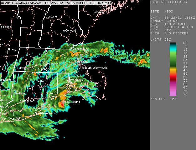
They still have some decent spread which shows the uncertainty even at 24-36h.
-
Yeah the eastward shift is definitely real from yesterday. It’s not a huge shift but it probably makes a landfall in RI more likely than SW CT/W LI. SE CT has always been in a pretty prime spot for landfall odds and I don’t think that has changed much. It’s extremely hard to actually know how a hurricane is going to behave on the scale a few 10s of miles...I’ve found that going by experience can be more useful than trying to dissect whether a piece of NWP guidance with its 8 trillion equations is going to be correct. In past experience, it’s very very common to see eastward leaks on guidance for New England TCs in the final 36 hours, which is why I was leery of the westward trends continuing a few runs ago. That doesn’t mean it will keep happening from here on out but hedging slightly east is not a bad way to go.
-
Yeah there was like a 1-2 hour period that it ripped pretty good down there. The sun actually came out for a time which probably helped destabilize the low levels a bit and then shortly after that we got some pretty big gusts. Usually it’s hard to get much better than 40-50 knots at ground level in my own experience (which admittedly doesn’t include a “real” tropical hurricane)
-
There will be a risk...good low level shear. But with the wind field kind of meh, it is probably mostly like weak EF0 spin-ups. We don’t have like 100-120 knots just off the deck to tap into like we might in a stronger system. Still gotta watch though. Even weak ones will be damaging...esp with recent rains.
-
Irene’s strongest winds might have been down on the cape. I had my highest personal measured there with the handheld. I think Phil and I got 63 knots at West Dennis beach.
-
Gem was basically the same as 00z. Maybe just a hair east. BID/WST/GON zone is where I’m zoning in in LF. If I was making a 2 sigma confidence interval though I’d prob go HVN/BDR to like Buzzards bay.
-
This is true. Our grid sucks where I am currently.....but CT seems on another scale up though. We saw the massive contrast in both Irene and the Oct 2011 storms too...like towns right next to each other on the border...the MA side would only have scattered outages and the CT side would be like 90-100% out.
-
Yeah I’m leaning BID right now into WST or GON.
