ORH_wxman
-
Posts
93,092 -
Joined
-
Last visited
Content Type
Profiles
Blogs
Forums
American Weather
Media Demo
Store
Gallery
Everything posted by ORH_wxman
-
September Discussion Thread: Bring the frost; kill the bugs.
ORH_wxman replied to moneypitmike's topic in New England
Yeah the autumns are definitely warmer now (particularly early autumn). Especially compared to the late 1980s and early 1990s. There was a string of obscenely frigid autumns back then which were cold even relative to the 20th century climate. The funny part is that we rarely ever got snow despite how cold some of those autumns were...lol. -
September Discussion Thread: Bring the frost; kill the bugs.
ORH_wxman replied to moneypitmike's topic in New England
EPS def looks warmer toward mid month...but seasonably cool before that. Above normal is nice though once well into Sept/Oct...back broken by then so a +10 day is fine. -
September Discussion Thread: Bring the frost; kill the bugs.
ORH_wxman replied to moneypitmike's topic in New England
Gonna feel like fall for the foreseeable future. Maybe a brief muggier day on Sunday? Otherwise that's a lot of football weather on the Euro. GFS tries to rebuild some heat toward mid-month but that is out in clown range. -
"Drought in New England" is typically an oxymoron.
-
Yes! He’s back!
-
That’s ETauntonMA (Bob) We gotta give him the Mohawk ski dude avatar again.
-
That is some sick looking convection about inject into this...
-
Agreed. The 2011 damage was significantly greater and that was a high end EF3 (though you can make a legit argument for low EF4). Hard to say what that NJ one was without more damage pics to reference...it was at least a solid EF2 anyway. Possibly EF3. If those structures were pretty high-end, then EF3 for sure.
-
I can believe that if it’s during that time. The 1810s-1830s were brutally cold here with the little data we do have. We were getting a ton of volcanic activity (including Tambora) aiding things and probably the decadal cycles helped too. Temps actually rose quite a bit from 1830s to 1880s before falling again toward the 1910s and then rising hugely in through the early 1950s (and then briefly cooling again in the 1960s/1970s).
-
There may be a temporary negative feedback of sorts...as ice melts closer to the pole, the refreeze starts a little earlier there because of the higher latitude which may offset the later refreeze further out on the periphery of the ice. That negative feedback would eventually get overwhelmed by a warmer climate.
-
Is there any evidence that minimums are occurring later? I remember running the numbers several years ago and there was no statistically significant trend...but maybe that’s changed. I can pull up all the dates tomorrow when back on my PC and check if nobody else has them handy.
-
I think the person doing it for the past year or two cannot do it this year. So we now face potential garbage BOS obs again...hopefully it doesn’t end up back at the water treatment plant halfway to the Flemish Cap.
-
September Discussion Thread: Bring the frost; kill the bugs.
ORH_wxman replied to moneypitmike's topic in New England
Agreed....you can tell anyway just by looking to the south in southern Oxford county...clearly there is big damage there. It wouldn't just stop like that...lack of obs is the culprit. -
September Discussion Thread: Bring the frost; kill the bugs.
ORH_wxman replied to moneypitmike's topic in New England
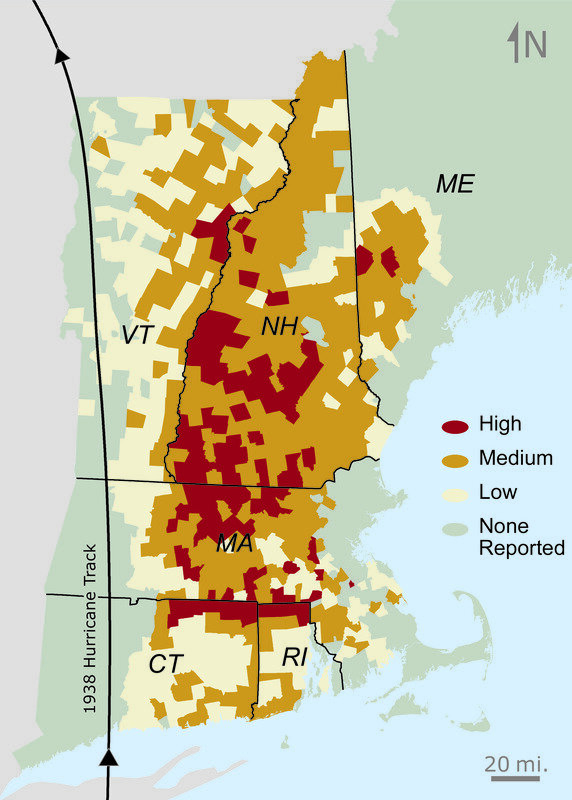
That's a pretty cool image, but it's modeled, so I try and stay with empirical obs. Here's another from Harvard....it shows damage by town...obviously there's some gaps in this analysis
-
September Discussion Thread: Bring the frost; kill the bugs.
ORH_wxman replied to moneypitmike's topic in New England
This image is from the harvard forest archives...the max damage definitely is a little west of, say, BOS, but it is focused over E CT/RI/C MA/E-central MA. It seems to taper some back near the CT river in MA (but not in NH)
-
September Discussion Thread: Bring the frost; kill the bugs.
ORH_wxman replied to moneypitmike's topic in New England
Well even west of ORH got in on the wind core...so I should probably say "central MA" too...so places like Palmer/Ware would have been in it....but typically the worst winds on a more tropical system would have been over the CT river but in this case it was over central/east-central MA and E CT/RI. -
September Discussion Thread: Bring the frost; kill the bugs.
ORH_wxman replied to moneypitmike's topic in New England
Yes it was...it was a minimal cat 3 at landfall in RI. -
September Discussion Thread: Bring the frost; kill the bugs.
ORH_wxman replied to moneypitmike's topic in New England
Carol was smaller than '38 too...it was more tropical and had an intact eyewall at landfall whereas the '38 storm was going extratropical with baroclinic assist....which why the worst winds in 1938 were over eastern MA/E CT/RI even though the center actually tracked over western CT and western MA near the NY border. -
My guess is we finish around 10th or 11th lowest on extent, but there is an outside chance we finish 13th with only 2009 and 2013 being above 2021 since the 2007 event if the weather cooperates enough and more of Beaufort ice hangs on.
-
That's for extent, but for area, we've seen August minimums. I believe 1992 was 8/31 and 2005 used to have an 8/30 min but recent revisions to the NSIDC database now has 9/3 as barely edging out 8/30 for the min. But 8/23 is ridiculous for a min....if an August minimum on area would occur, it would be around the last day or two of the month.
-
September Discussion Thread: Bring the frost; kill the bugs.
ORH_wxman replied to moneypitmike's topic in New England
The cool shot on the Euro next week looks nice. Gonna feel like fall. -
We've fallen below the 8/23 value on NSIDC area. The 8/23 value was 3.38 million sq km and today we are at 3.26 million sq km. 8/23 wasn't a very realistic minimum date.
-
Maybe KGAO can catch the eastern eyewall. That’s prob the station to watch going forward. Too bad there isn’t one right on Grand Isle. They h e an airport but no obs come out of there.
-
DLP obs is over 30 min old though...wonder if they croaked too.
-
KDLP 291310Z AUTO 12075G96KT M1/4SM FG 25/25 A2917 RMK A01