ORH_wxman
-
Posts
93,092 -
Joined
-
Last visited
Content Type
Profiles
Blogs
Forums
American Weather
Media Demo
Store
Gallery
Everything posted by ORH_wxman
-
I think it’s 11/12/77. Maybe the 13th. Can’t remember now. The weaseled a 32 on the nose last night so this year won’t break that record. ORH is running a bit warm right now too.
-
You had like 15-18" in 3/13/18
-
Maybe the tip of Cape Ann isn't. But most of it would be in the 50 zone. They can be kind of boom or bust there. There's also no way you didn't break 30" in 2017-2018. The 1/4/18 and 3/13/18 events alone almost get you there....then add events like Xmas 2017, Feb 17-18, Mar 7-8 and then other random 2-4" type events
-
I'd prob draw SNE to look more like this (I rushed this just now, so I didn't put in as many obsessive details as usual)

-
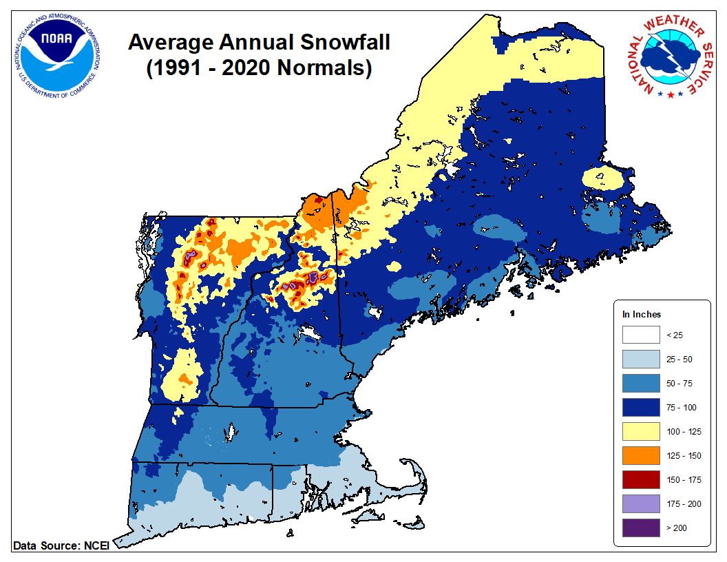
Yeah it's all bogus north of BOS....those north shore towns should be over 50....unless maybe you are literally out in the ocean like the tip of Cape Ann or maybe some of those communities near Marblehead. The 75+ should also extend down to far NW CT in Litchfield county and you could prob put a 100-spot or two in the northern Berkshires on the crest there over 2000-2500 feet.
-
Also the sub-25 zone on the Cape is fake. The only place that may come close to not averaging 25" in SNE is near GON....but even there is suspect for 1991-2020 since that region had a really good run recently.
-
Agreed....the 75" should come down to almost ORH airport (they were 72.8" on the latest 1991-2020 avg) along the spine there in Princeton/Rutland. Also, prob shouldn't have that sub-50" zone in 495...that is totally fake. Prob a bad coop or two affecting that plot in there.
-
Can see the signs of change near the end of the EPS for later in the month, we'll have to see how this tracks....whether it starts amplifying or getting pushed back some. Often, a pattern change can be rushed a bit by guidance so we'll see.
-
March really throws it off...but most of us in New England already know that March is a big part of our snow climo. Those 1991-2020 April numbers almost certainly too low too since they aren't including April 1996 and 1997 (both over 20") as those were part of the ASOS blackout years.
-
ORH 1991-2020 averages: Oct: 1.1" Nov: 1.9" Dec: 14.9" Jan: 18.2" Feb: 21.1" Mar: 13.7" Apr: 1.9" Total: 72.8" DJF: 54.2"
-
There's a weak inverted trough trying to set up for Thursday night, so it's possible some folks could see their first flakes if there's enough moisture/lift to squeeze out some flurries or a snow shower. Other than that, pretty boring through mid-month, gets mild again before perhaps a change in the final 1-2 weeks of the month. Ensembles and the weeklies still showing this.
-
BOS went back to being biased warm in their ASOS. Not sure what the issue is. ORH would prob be closer to 5th if the siting didn’t change in 1948. Several of the warmer autumns were at the old site which was warmer than the airport.
-
MQE - #4 ORH - #9 PVD - #2 BDL - #6 BDR - #2
-
Probably a question of semantics....if we have a similar autumn, to say, 1971....but we end up like 0.3F warmer or something....I would classify it as correct to say "we've had autumns like this before".....if the record is smashed by like 2 degrees, then that would be a more dubious statement. FWIW, only BOS out of the first-order stations in SNE is currently having their warmest autumn on record...and their temps are running a bit "questionable".
-
Yeah the shortwave gets pinched off from the northern stream which allows the cold to moderate faster. But this is still 7 days out. I recall models doing something similar with 11/15/18 too in the medium range.
-
It’s a little warm but close enough to keep an eye on
-
You got the years correct but that is 4 seasons in a row. ORH has never previously even done 3 in a row and of course as I become a young snow weenie, that’s what I get greeted with.
-
You are thinking of 11/19/86 I think. But there were events on both 11/11/86 and 11/11-12/87...butt he fast moving nature of the storm with intense rates pre-dawn matches the 11/19/86 storm. http://www.meteo.psu.edu/fxg1/NARR/1986/us1119.php#picture
-
Yeah but that is an El Niño pacific there which makes me skeptical. There’s a huge Aleutian low where normally in La Niña we see a high/ridge there. The key in La Niña is to get the ridge poleward so it’s shooting up into AK/Bering Strait.
-
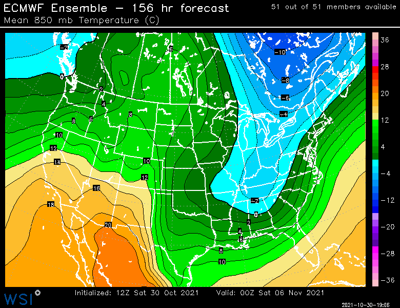
The temps will be plenty good for snow making for at least 5-7 days early November. But it does look like it gets pretty mild for a time mid-month. But at least for the ski areas, man made snow will be pretty durable as long as no torching 55-60F cutters come along with that mid-month pattern.
-
Yeah there's been a dearth of good snow events historically in the first week of November here. We've had more impressive stuff in late October. We did have a pretty good one though in 2012...Nov 6-7, 2012.
-
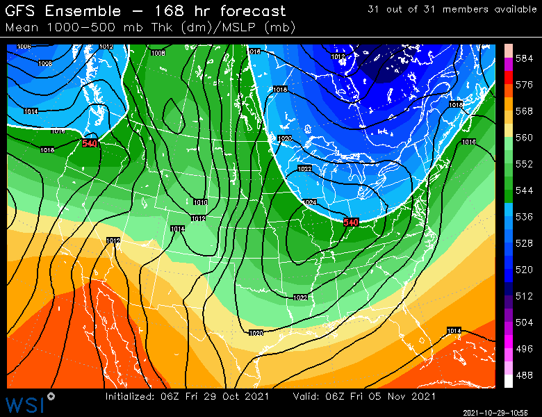
Yeah when I saw that trough orientation and the shortwave digging around the base of it, I was thinking "It would have been nice to see another couple 12 hour panels just for kicks" But while that exact solution is unlikely, you can see how the blockiness back in central Canada is going to aid in getting some exotic-looking evolutionns. When you have such an extreme meridional flow like that, you can have shortwave round that corner with superb efficiency. It doesn't take much room to get it to pop a big one. Typically, we'd grumble the ridge/trough axis are too far east, but not in that case.
-
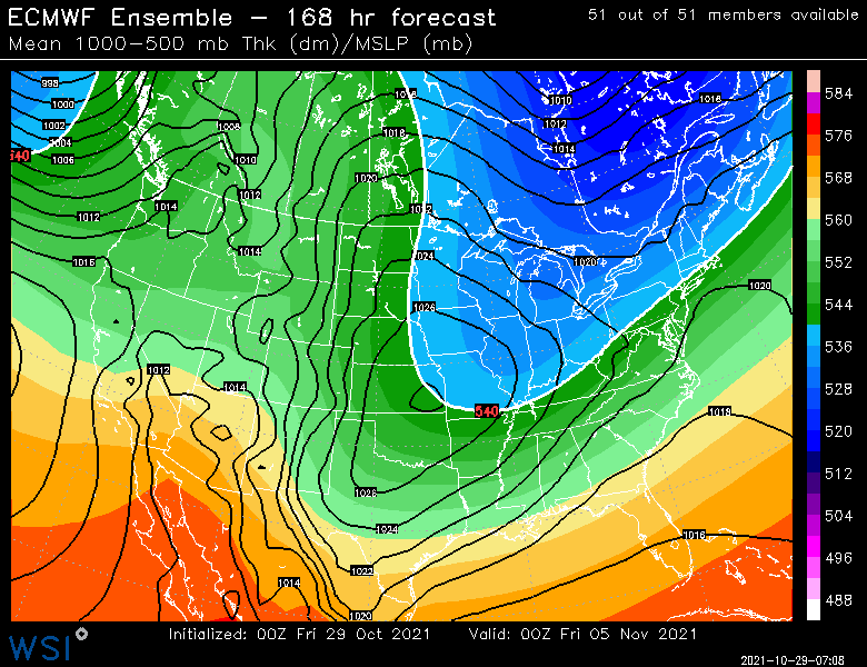
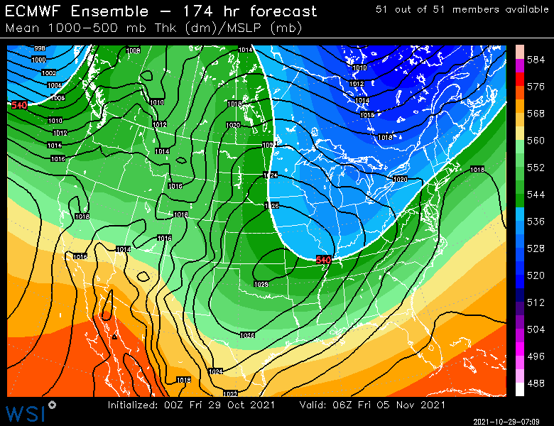
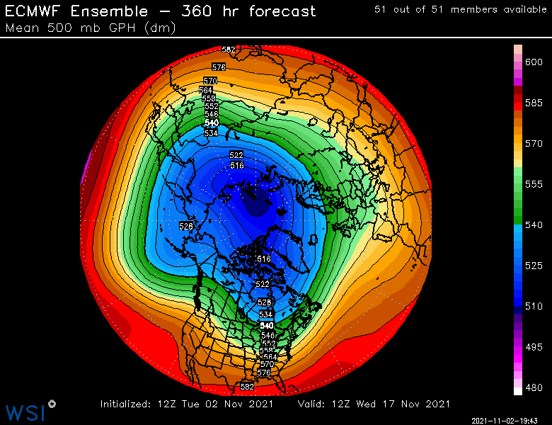
It's a pretty deep trough with some blocking upstream in Canada which will help shortwaves rotating around it dig. Definitely something we need to keep an eye on. Regardless, the first week of November looks solidly below normal. Then it looks like a bit of a torchy pattern mid-month and then we'll see if that late-month snap back to colder materializes.
-
Depends what you are talking about....any flakes at all? That's probably got a half-decent chance. Something like advisory snows or better? That's not very likely for the non-mountain areas being 7 days out....but it's worth keeping an eye on because of the ensembles support for something.
-
Both EPS and GEFS have something to keep an eye on for 11/4-11/5.