ORH_wxman
-
Posts
93,092 -
Joined
-
Last visited
Content Type
Profiles
Blogs
Forums
American Weather
Media Demo
Store
Gallery
Everything posted by ORH_wxman
-
3k def looks better than the 12k....though the 12z 3k did trend a little east of 06z, but not nearly as much as the 12k did.
-
Yeah this run is not gonna get it done for a big event...this would be an advisory event for eastern areas I think.
-
122z NAM looks like it will be more subdued than 06z....spacing between the two shortwaves is less through 24h.
-
Put your obs for today in here https://www.americanwx.com/bb/topic/56475-january-2022-obsdisco/page/60/#comments This thread should be for 1/7
-
LOL. I feel like we need a therapy thread…
-
Nice tick west on 06z euro. The shortwave definitely has been looking nice on the 06z runs. Hopefully that Carries into the 12z suite.
-
Glad I went to bed early last night…I just got caught up reading like 3 pages melting down about the 00z NAM. Some of you need to go back to spring training…lol. Luke wins the prize for best prediction by saying the the 06z NAM would come in zonked. Looking at other guidance, I really like the strength of the shortwave. The 06z suite is coming in strong with it. Hopefully euro follows in a bit.
-
I still wake up with a cold sweat with nightmares of 2/24/89 in my head.
-
Jan 2019 was pretty impressive. ORH had a high of 1F. Had to go back to 1994 to get that. Even Jan 2004 didn’t beat that.
-
You could see the better spacing in the shortwaves early on. Downstream ridging was a bit better.
-
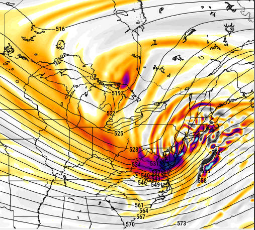
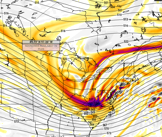
Here's H5 on the RGEM....you can see how nicely the vort is curling up into ACY area (and eventually LI) and it's tight enough that there's good downstream ridging....it's a bit more efficient in that department than the 18z NAM which is why the RGEM was a big hit and the NAM was more of a moderate event.
-
Yeah RGEM went zonkers.
-
No argument 12z looked better. My gut still says this comes back some though.
-
It came in shallower angle like Tip mentioned. It does go negative with the trough sooner but the trough itself isn't quite as deep. But the overall look is pretty nice....you have the vort curling up from the Delmarva into LI and then the Cape....that is a classic scenario for midlevel goodies over SNE.
-
Regardless of any actual trends in the height field or vortmax, I do think the storm circulation will end up tucked a bit closer to the max PVA than some of these runs show. If you get your conveyor all mucked up chasing convection, then you'll have some uglier looking solutions that may or may not be model phantoms. Sometimes the convection is correct...but I'd be leery of it, especially on hyrdostatic model guidance. That said, there are multiple other factors such as the heights in SE Canada which are important for ridging downstream of the shortwave and of course, the shortwave itself. Then you have the western ridge too as Tip and Chris have already discussed a few times.
-
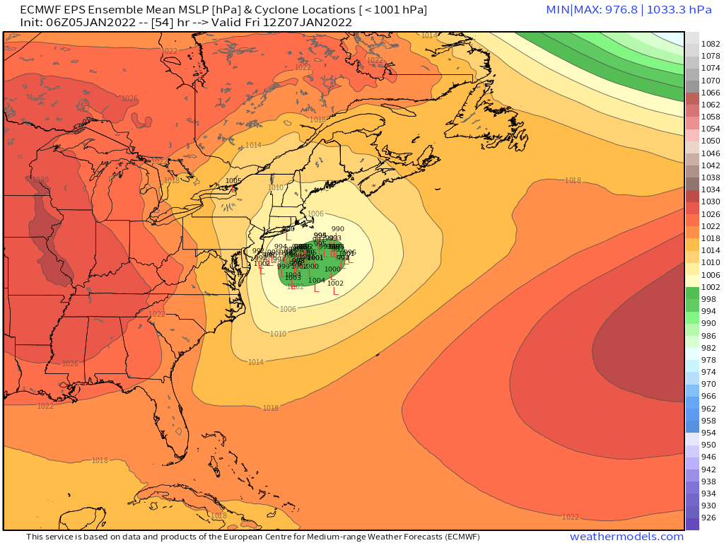
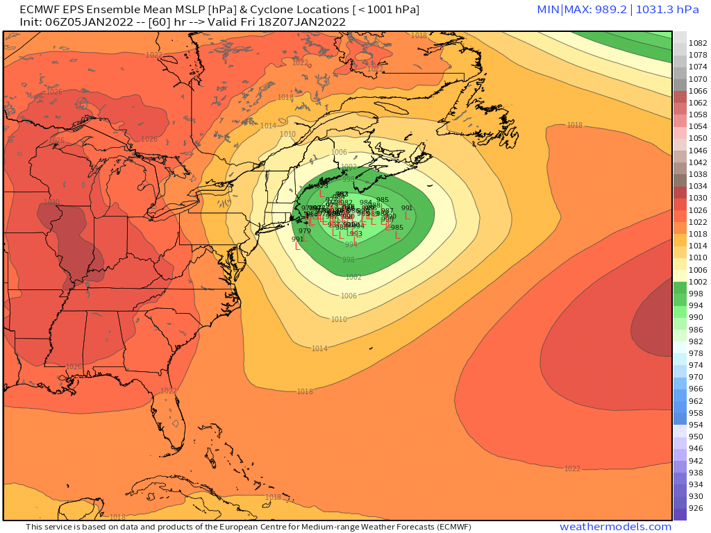
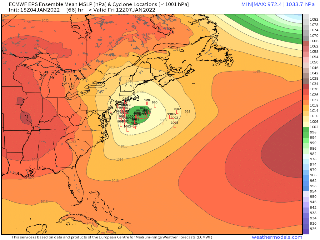
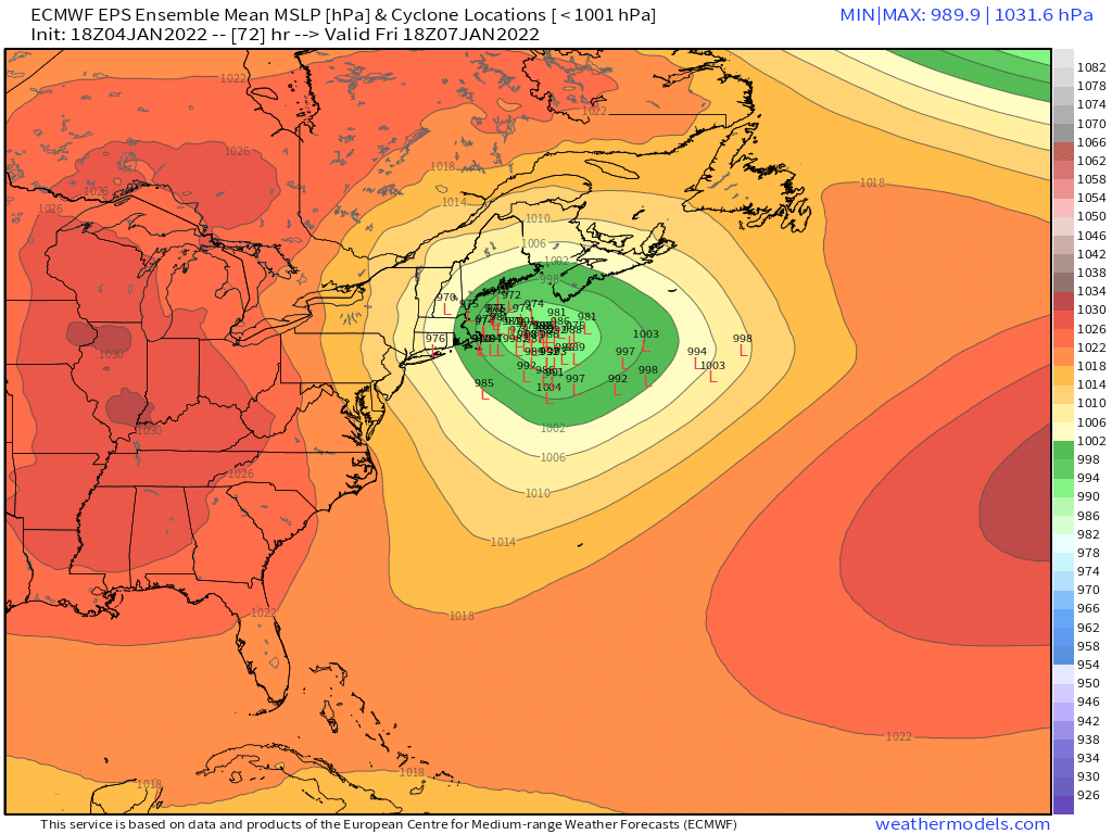
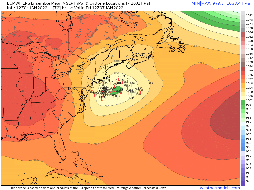
Still a good spread even at 72h....clearly a decent cluster still west of the BM.

-
Yeah you want to see that ridging poking further north into Quebec, but in my experience, model guidance tends to underestimate the ultimate strength of these consolidated vortmaxes and associated amplification. Maybe it doesn't happen this time, but I'd be somewhat surprised if we don't start seeing a bit of a shift back west all else equal. If we get more confluence up north, then obviously that would offset a stronger vortmax.
-
It won;t melt if there's a decent warning criteria storm...if we only get 2-3" of blower fluff, then yeah, it might.
-
Single digit highs for 1/11 on Euro in SNE....below 0F in NNE. Cold stuff....not since Jan 2019.
-
It's pretty damned potent vortmax. Unless it weakens a decent amount, my guess is future guidance starts reacting to it by tucking this thing closer to the PVA.
-
Maybe it's just me, but I kind of like this look...
-
Prob a modest tickle east...though it wouldn't surprise me if it basically held serve since it was already a little bit east.
-
Yeah I'm still thinking this comes back west some...they usually do when you have that nice consolidated vort energy near base of trough and when there's some sfc reflection chasing convection. We actually saw this somewhat in the 12/17/20 storm last winter. We're obviously dealing with an eastward trend this 12z cycle, but there's still plenty of cycles left.