ORH_wxman
-
Posts
93,092 -
Joined
-
Last visited
Content Type
Profiles
Blogs
Forums
American Weather
Media Demo
Store
Gallery
Everything posted by ORH_wxman
-
Monitoring a potential important TV to East Coastal storm: Jan 17
ORH_wxman replied to Typhoon Tip's topic in New England
We'd all take drugs if we could have gotten rid of the December RNA. -
NAM gets some light snow into eastern SNE this run...parts of NNE gets some light snow from the northern vort. Nothing exciting though.
-
EPS actually likes that system too...Has a closed isobar low SE of BM ar 246 hours....which is kind of hard to do at that lead time. Beyond that, EPS keeps reloading that western ridge....you'd have to think it's just going to be more chances when you have meridional flow like that in conjunction with frigid cold lurking nearby (see Hudson Bay)...esp when we get pieces of that PV breaking off and relaxing the gradient temporarily. That western ridge is like gasoline ready to ignite potential.
-
Monitoring a potential important TV to East Coastal storm: Jan 17
ORH_wxman replied to Typhoon Tip's topic in New England
Agreed...more progressive. It does have very mature conveyor belts with deep inflow, but I don't see this as being a 30+ hour job. Prob 12-15. -
Monitoring a potential important TV to East Coastal storm: Jan 17
ORH_wxman replied to Typhoon Tip's topic in New England
Confidence high on a storm on the EPS, but plenty of spread....but not bad for D6. -
Monitoring a potential important TV to East Coastal storm: Jan 17
ORH_wxman replied to Typhoon Tip's topic in New England
Lets go Feb 1-2 redux from last year....then we'll have to have Scooter's face photoshopped onto the FINISH HIM image. -
Monitoring a potential important TV to East Coastal storm: Jan 17
ORH_wxman replied to Typhoon Tip's topic in New England
I don't mind a hugger...just don't track it over my fanny....even an LI to Cape track would be an awful lot of snow before any taint. -
Monitoring a potential important TV to East Coastal storm: Jan 17
ORH_wxman replied to Typhoon Tip's topic in New England
Ray is Johnny Cage being finished off by sub-zero temps after the rain
-
Monitoring a potential important TV to East Coastal storm: Jan 17
ORH_wxman replied to Typhoon Tip's topic in New England
Yeah this looks like an inland runner trying to extrapolate at 132. -
Monitoring a potential important TV to East Coastal storm: Jan 17
ORH_wxman replied to Typhoon Tip's topic in New England
That one was kind of a hugger too...not as inland as the GFS/GGEM solutions today, but that 1/2/87 storm went over the elbow of the cape and was a lot of slop for the coast....but not too far inland got croaked. That upper 495 corridor in particular got hammered....Pepperell to Harvard MA corridor had 18-24"...ORH area had over a foot as well. -
GEFS basically all over the map

-
That Ukie look at D6 is good for New England. Not as tucked as gfs or GGEM and it would likely max out a bit further north too.
-
The antecedent airmass is pretty good so there will be some wiggle room, but obviously you can't indefinitely stave off the warmth on that type of track....but something slightly east of that would probably be pretty good. Heck, even this solution was prob a solid thump over the interior.
-
Sure it can....you just have to track the storm up into your fanny and it will rain there. Happens even in frigid patterns...how'd you do on January 17, 1994?
-
GFS is gonna be a hugger....might flip us to rain.
-
Rather than go fatality on you, I'd prob just do the upper cut on the spike pit arena.
-
That's actually a pretty good hit for the Cape and Canal region. 1-2" maybe for the rest of eastern MA
-
NAM is def trying.
-
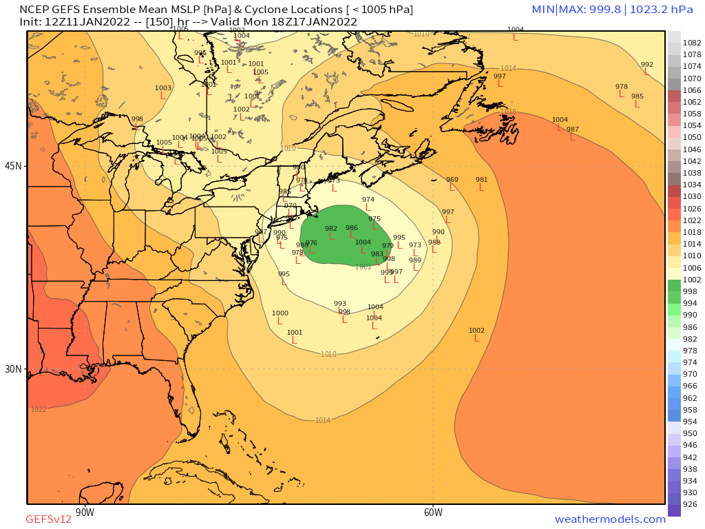
Monday starting to look really good on EPS....even though 06z EPS only goes to 144, you can see that a lot of those would likely turn the corner based on H5.
-
EPS definitely looked interesting. More so for the 1/17 threat but can’t quite rule out 1/14 yet.
-
What is the GFS doing…
-
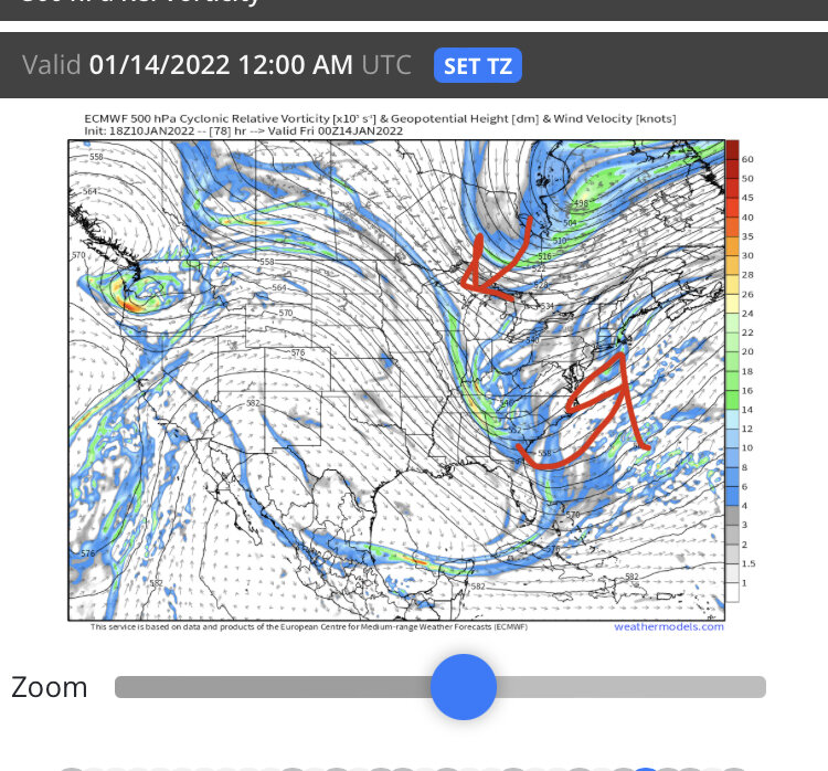
Man, we just need that PV lobe to dig a little further west and you’d prob get a partial phase enough to send this right up 70W. Wouldn't take much…I exaggerated the arrows but you get the point
-
Sorry to hear. Glad it was a nice ceremony. Let’s hope we get an awesome stretch of winter wx…it always helps me through a tough time when I can be distracted by my passions.
-
We need that PV lobe dropping down to trend a little west to give this room to amplify up the coast. I circled it in the image below
-
That’s not even a bad look for New England. But prob isn’t going to satisfy your blizzard fetish.