

ORH_wxman
-
Posts
93,092 -
Joined
-
Last visited
Content Type
Profiles
Blogs
Forums
American Weather
Media Demo
Store
Gallery
Everything posted by ORH_wxman
-
GFS was trash too until really late in the game. Model guidance overall struggled in this one for sure.
-
OBS/DISCO - The Historic James Blizzard of 2022
ORH_wxman replied to TalcottWx's topic in New England
Just got back in from snow blowing. Had near 12” on most measurements but it varied a bit with the wind. Was hoping to crack 18” but that may be tough unless we can get the good snow growth back in here. It’s gone to baking powder the last 45 minutes or so. My guess is we add another 3-4” and call it a storm. The wind has been really impressive though. This is the windiest snowstorm I’ve had since maybe Feb 2013. -
OBS/DISCO - The Historic James Blizzard of 2022
ORH_wxman replied to TalcottWx's topic in New England
Looks like about a foot here eyeballing. About to go measure and run the snow blower again. -
OBS/DISCO - The Historic James Blizzard of 2022
ORH_wxman replied to TalcottWx's topic in New England
Def gonna be a few 30 burgers I think in SE MA unless everything falls apart quickly this afternoon. -
OBS/DISCO - The Historic James Blizzard of 2022
ORH_wxman replied to TalcottWx's topic in New England
That is an epic band. Getting stronger too you near BOS and north shore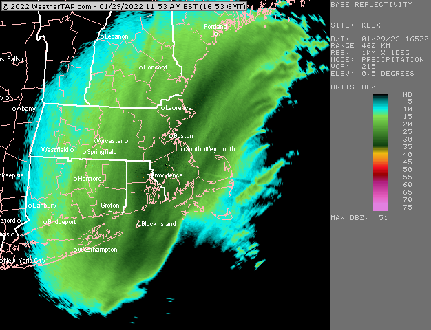
-
OBS/DISCO - The Historic James Blizzard of 2022
ORH_wxman replied to TalcottWx's topic in New England
Vis is even lower than before
-
OBS/DISCO - The Historic James Blizzard of 2022
ORH_wxman replied to TalcottWx's topic in New England
Lol yep. He’s done several launches this morning. -
OBS/DISCO - The Historic James Blizzard of 2022
ORH_wxman replied to TalcottWx's topic in New England
500mb Wind still SSE at stoneybrook is good to see. -
OBS/DISCO - The Historic James Blizzard of 2022
ORH_wxman replied to TalcottWx's topic in New England
My buddy is down at suny stoneybrook doing balloon launches. 16z sounding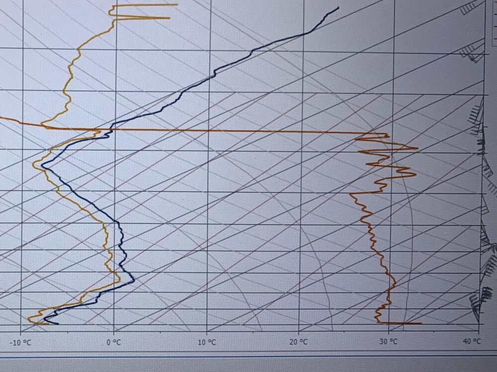
-
OBS/DISCO - The Historic James Blizzard of 2022
ORH_wxman replied to TalcottWx's topic in New England
Measured 9” about 10 min ago. -
OBS/DISCO - The Historic James Blizzard of 2022
ORH_wxman replied to TalcottWx's topic in New England
Some better push west now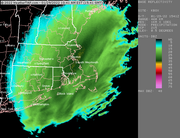
-
OBS/DISCO - The Historic James Blizzard of 2022
ORH_wxman replied to TalcottWx's topic in New England
Maybe a little bit it’s not done on INT west up here. I can see a good push west now near cape Ann and off SE NH -
OBS/DISCO - The Historic James Blizzard of 2022
ORH_wxman replied to TalcottWx's topic in New England
The trees behind those snow cover cars are about 150-200 yards away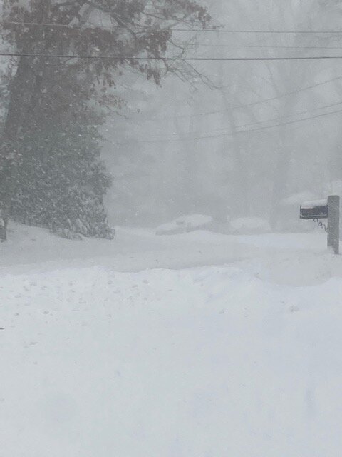
-
OBS/DISCO - The Historic James Blizzard of 2022
ORH_wxman replied to TalcottWx's topic in New England
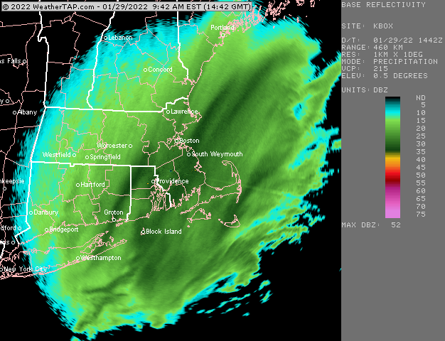
Yeah even in this 25-30 dbz mass to the west of the death band, it’s sick. Gotta be 2” per hour anyway at the moment. I ran snow blower in driveway a couple hours ago and there’s at least 3” again eyeballing. Maybe more.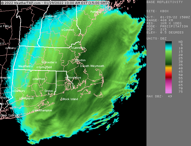
-
Yeah GFS actually looks most aggressive with the H7 low out of the 12z guidance so far.
-
I don’t see anything enlightening in the last hour. I think guidance is mostly doing ok except it’s probably a bit light under the banding over E MA. You should get some outer bands in your area. You can still see a bit of a Nw push in E CT
-
BOS will prob have a foot like 2-3 hours from now. Lol. They must have at least 6-7 by now. I’m already over 6 and they have some serious meat to go through
-
OBS/DISCO - The Historic James Blizzard of 2022
ORH_wxman replied to TalcottWx's topic in New England
That is legit there. That’s gotta be 2-3” per hour easy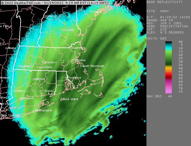
-
OBS/DISCO - The Historic James Blizzard of 2022
ORH_wxman replied to TalcottWx's topic in New England
BOS is about to get absolutely annihilated on radar. That band just about to enter -
OBS/DISCO - The Historic James Blizzard of 2022
ORH_wxman replied to TalcottWx's topic in New England
I think it might keep creeping out to you eventually. But not sure if it makes it to ORH. -
OBS/DISCO - The Historic James Blizzard of 2022
ORH_wxman replied to TalcottWx's topic in New England
Getting crushed right now in the Ginxy band. Can’t see more than a few hundred yrds. -
OBS/DISCO - The Historic James Blizzard of 2022
ORH_wxman replied to TalcottWx's topic in New England
Ginxy is gonna pull a 20-burger I bet…maybe 2 feet -
OBS/DISCO - The Historic James Blizzard of 2022
ORH_wxman replied to TalcottWx's topic in New England
Yeah i think dendrite has me as the snowman on his customized radar. I’m basically where Holliston/Ashland/Hopkinton all meet. -
OBS/DISCO - The Historic James Blizzard of 2022
ORH_wxman replied to TalcottWx's topic in New England
Wow really picked up here just now. Ripping as that Ginxy band is extending north.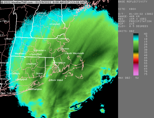
-
OBS/DISCO - The Historic James Blizzard of 2022
ORH_wxman replied to TalcottWx's topic in New England
I’d be surprised if Kevin got another foot, but it’s not out of the envelope of possibilities. If he grabs the western edge of the deformation band, then it could pile up quickly for a few hours.


