ORH_wxman
-
Posts
93,110 -
Joined
-
Last visited
Content Type
Profiles
Blogs
Forums
American Weather
Media Demo
Store
Gallery
Everything posted by ORH_wxman
-
I feel like the RAP is too warm in that layer...NAM was WAYYYY colder and the NAM is usually pretty good aloft...the RAP had a bunch of us barely below frezing at 925 while we were all slamming heavy pellets at 32F earlier with a massive fat warm layer....which doesn't make any sense. It would require a very cold layer in there to get pellets.
-
This is what I always envisioned when TWC had "wintry mix" as the forecast back when I was a kid. It usually didn't verify like this (instead it was like straight ZR or a defined transition from snow to sleet to ZR), but this is definitely that type of day where truly a mix...we've had ZR/IP and SN- all throughout this morning and often at the same time.
-
Perfect for skiing....get that dense base down and then fluff the top
-
I don't think it looks that cold after this weekend...I wouldn't be surprised if we have plenty of mildly above normal days, but it's also not a no-threat pattern for snow through mid-month. The atmosphere will support snow with a decent track...it's plenty cold for that. We might get a deeper arctic shot toward mid-month as the western ridge amplifies.
-
We're getting absolutely ripped with pellets right now and a LOT of pixie dust....there's def crappy flakes mixed in now due to that very cold layer in the 925-950 region.
-
Ukie was pretty good for deep interior north of the pike...like N ORH county into NH and Maine.
-
Almost like there is yet another pulse up around Essex county....I noticed earlier they kind of rotted in the 29F range and then quickly went down to the 26-27F range the past hour or so. We're now getting into that 29-30F range here....everything is rapidly icing up solid, not just elevated or snow covered surfaces anymore. It'll become really nasty when it falls another pulse down into the mid 20s.
-
Tickled below 31F here now...any standing water is quickly freezing up....being covered pellets also expedites the refreeze.
-
GGEM has a little snow for interior....but doesn't pop it quickly enough....hammers DE Maine though.
-
Yeah likely an interior special if it gets close enough....though if it can deepen fast enough, it could prob collapse the 900-05-mb layer back toward the coast, but that is a longshot.
-
HRRR has some, though not quite as enthusiastic. RAP has a nice burst too, though mostly for RI/SE MA....but we do get a little flip to snow around 00z here prior to that second burst coming in for SE MA?RI on the RAP.
-
Yeah it's absolutely ripping down the coast now....I see 29F in Hull, MA...lol. Coldest spot at that latitude in MA east of the west slope of the Berks.
-
There are prob going to be some crappy flakes mixed in soon because the cold layer gets to like -9C or -10C which supports snow growth even though its torching above that layer.
-
Looks like the 30F isotherm is roughly from Chelmsford to Burlington to Winchester to Revere....it goes further south the closer to the coast you are. The Euro actually ended up pretty darned good with rotting us near 31-32F for several hours before the 20s get here. But we're pounding sleet anyway despite being near freezing....since it's frigid just off the deck at 925-950.
-
Just pounding pellets....everything covered including the roads.
-
12z Reggie brings a band of snow into SNE tonight with that sharp shortwave...drops around an inch or so from central CT to E MA. So maybe something to watch.
-
Starting to get accumulation now of pellets. Didn't even hear them at first but looked outside and saw a thin translucent coating on the car and walkway. Sure, enough, I see them pinging off the railing.
-
Awesome...I love to see the ski areas hit hard...esp in western Maine where they don't benefit from upslope as much....this should be a fantastic base builder for Shawnee and SR....get a couple more of these to make sure skiing is great deep into March/early April.
-
All the mesonet stations near Logan airport are below freezing....impressive.
-
3km NAM has snow for the south shore and Cape into early tomorrow AM with that sharp shortwave.
-
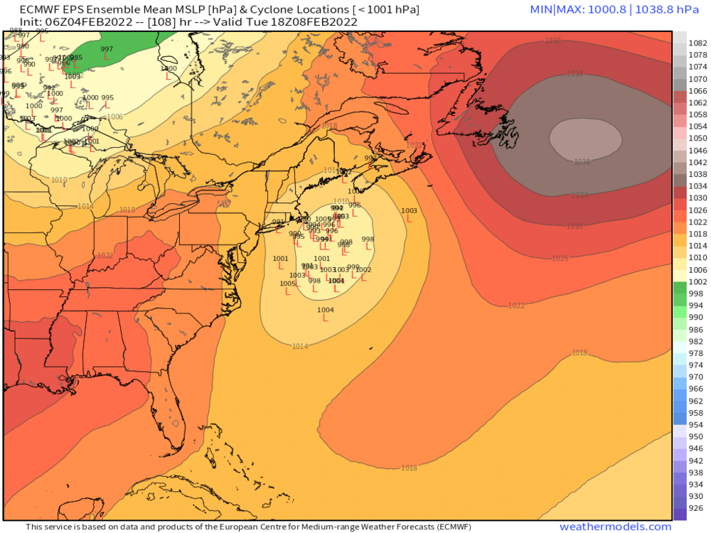
06z EPS was a lot more interested than 00z
-
There will be some light precip all day....but the steadier/heavier stuff is only a few more hours.
-
Ya'll can take the CC discussion to the CC forum or PM.
-
925 gets really cold quickly....NAM had it to like -6C near the pike by 10am.
-
Looks it's just starting to try and glaze a little here now. 31.5F.