ORH_wxman
-
Posts
93,092 -
Joined
-
Last visited
Content Type
Profiles
Blogs
Forums
American Weather
Media Demo
Store
Gallery
Everything posted by ORH_wxman
-
This is the type of shit system we’d get in 2001-2002…I remember complaining to my roommates how every system had a low sitting up in Montreal so even a decent sfc track didn’t have much precip and what precip that did fall ended up mostly rain.
-
The WAR is pretty stout this time around too so this could get pushed back west over time. We’ve seen that happen in the past when you have a strong WAR.
-
12z Ukie looks like it’s setting up for something interesting at 144. GGEM had the storm but well offshore. Couldn’t sync up the northern and so it been stream quite well enough. GEfS has a few rogue members that look good otherwise the GFS suite wasn’t interested. But if Euro and EPS come in decent, then I’ll start getting a bit more interested. There’s some larger scale features that do support a system (namely the amplified western ridge.)
-
31F and overcast....too bad we couldn't get some of those better echoes form RI up here earlier as we had some good snow growth. Now we get 33-34F and rain later it looks like.
-
Good fatties falling again here. Best echoes are stubbornly staying south though.
-
Getting good snow growth now as echoes move in. Everything covered.
-
I’d like to see some non-euro guidance show this system today. Even the EPS was like warm as Scott said so we need to increase support. There’s a decent western ridge so it has some larger scale support but that in itself isn’t going to make the storm happen.
-
Nothing on radar yet here but light snow grains falling here the past 10-15 min. Must all be below the beam.
-
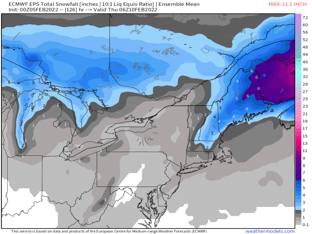
Euro still not really interested for SNE outside of NW MA. It starts as a little snow from interior CT around Kevin up to 495/ORH but not much. Maybe a coating. Very good run for the IZG corridor over to Phin and over to Tamarack’s hood…like 5-10” there.
-
I will say that the GEFS defeated the EPS for early February. Doesn’t mean they will win this time but the EPS kept trying to torch us in early February for awhile until they finally caved.
-
Quite the model war for the long range. GEFS are still very meridional and cold into 2nd half of February while EPS torches us.
-
Rgem has been cooling (and some other guidance too). The 18z run has a sustained period of snow tomorrow morning/midday for most of interior SNE. It’s not much but 1-2” wouldn’t be shocking.
-
That is horrendous for there. How much did you get in 2015-16? That was another historically bad year in NW MA.
-
This could actually be one of those events where some ice happens in lower spots because the in-situ CAD would be extremely shallow. Like ORH could be 34F and raining while ORE or FIT is 29F and ZR.
-
It’s kind of a faux sfc track though because the upper air is way west…we get this weird IVT out ahead and the flow at 925/850 is due south. The storm might as well be over ABE. By the time the thing consolidates it’s way northeast of us. Just another turd setup really that masquerades as something that “should” look good for us.
-
Interior SouthWestern Maine is in a good spot for this one. I could see Shawnee being close to the jackpot.
-
Yeah most guidance is a disjointed mess which probably means this is mostly a non-event until you get to Maine. Could be some marginal advisory snows from N ORH into interior NH but the disjointed look sucks…gonna want to trend it into more of a closed circulation aloft to make this more interesting.
-
Yeah the recent euro runs have been almost nada for SNE…non-event.
-
Not sure what to think on this one. Safe bet is to just say almost nothing except N ORH county for SNE and then a narrow stripe into interior NH and W Maine but there’s still some major differences on guidance. If 06z GFS is catching onto a legit trend, then it could get more interesting. Would still need to trend a little more. My guess is the 12z suite will clarify things more…and I’m not expecting much of anything interesting for most of SNE.
-
It’s kind of a putrid system on a lot of these runs. Mostly the IVT out ahead of it…a few runs like some of those NAM solutions are a little more real…those are what it will take I think for more than 3-4” of paste…maybe a few spots could try and pull 6” in the IVT scenario but they would prob be isolated.
-
Parts of central/western CT too where they didn’t get as much from the 1/29 system.
-
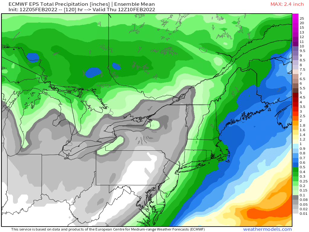
12z EPS:

-
Nitpicking, but can’t really use percentages since he has a different average than you. Gotta use standard dev. But anyways, you had an epic ratter but also a season near your average in 2018-2019. Don’t really want to derail this thread any further though. I agree with the larger point that Ray’s area isn’t egregiously unique in the past 4 years…maybe just somewhat. I’ll be western MA gives him a run too.
-
If you go by just since 2000, Ray prob averages over 70”…so his deficit would look even worse the last 4 years. He was using long term climo numbers.
-
Yeah that’s the system that has had some larger scale support. If there’s a big dog in this pattern, it likely comes from that trough.