ORH_wxman
-
Posts
93,092 -
Joined
-
Last visited
Content Type
Profiles
Blogs
Forums
American Weather
Media Demo
Store
Gallery
Everything posted by ORH_wxman
-
Preliminarily ... a medium impact partial Miller B, Friday
ORH_wxman replied to Typhoon Tip's topic in New England
HRRR really hitting north of the pike later tonight/early tomorrow. We’ll see on that but it’s been trending better. -
The TPV is still important imho. I agree the longitude of the western ridge poses issues for a further west track but the TPV getting pinned over SE Canada allows more wiggle room for winter wx in the sensible sense. Like if this tries to cut into PIT/CLE but then it gets forced out underneath us on a secondary reflection….that’s a big winter storm for us versus maybe a quick front-ender to mild rain.
-
Lot of CAD that run. Would be a large area of icing with that high. Regardless, the details are irrelevant…larger point was the TPV getting tucked into SE Canada. That’s all we can really take from the run.
-
GFS def not budging on the PAC look
-
About 10% of the members had measurable snowfall for 12/11-12/12 about 5-6 days out and most people ignored 12/11 until we got much closer.
-
Scooter's probability maps are going to look a lot uglier today....

-
That says nothing about probability.
-
Embrace it.....


-
EPS is trending toward the OP run too with the western Canada energy.
-
Preliminarily ... a medium impact partial Miller B, Friday
ORH_wxman replied to Typhoon Tip's topic in New England
It tries to change you over too but I don't like how far southwest you are on that. But we'll just have to wait and see. Guidance has been slowly trending southeats with the SFC low today, so maybe it can produce a little band later further south. -
Nice squall line from CAR to Havana.
-
Preliminarily ... a medium impact partial Miller B, Friday
ORH_wxman replied to Typhoon Tip's topic in New England
Like 3 or 4 of us talked about it further up -
Pretty apparent by 96h that it would. This will be Chicago track or roughly somewhere near there.
-
Tropospheric Polar Vortex
-
GEM can't buy a coup on a snow event, but it will be the first to sniff out the TPV getting trapped and taking a blizzard away.
-
LOL brutal.....Cranmore shut down.
-
Preliminarily ... a medium impact partial Miller B, Friday
ORH_wxman replied to Typhoon Tip's topic in New England
One of my old contacts said 7-8" in Winchendon.....they got slammed up there. Might end up with a foot. AWT. What's funny, is the crazy gradient between Cheshire county and N ORH county that I was mocking almost happened....lol. IT was def a bit south of that weird BOX map.....Rt or just south of Rt 2 seems to be the big dividing line. -
It looks a bit worse than 00z through 96h up north....I'll be somewhat surprised if this solution ends up cold/snowy.
-
Preliminarily ... a medium impact partial Miller B, Friday
ORH_wxman replied to Typhoon Tip's topic in New England
Over an inch of QPF at ORH now....brutal waste of a nice system otherwise -
Euro is kind of going hybrid again on the TPV look like 00z....would've liked to see it definitively go more GFS/NAM route.
-
Preliminarily ... a medium impact partial Miller B, Friday
ORH_wxman replied to Typhoon Tip's topic in New England
Euro looks interesting for tonight....I'd feel better up by Ray's hood but maybe down here I can grab an inch or so. -
I mean it's Tblizz....never saw a threat that wasn't already cooked at D7. Call it the "Reverse JB" model.
-
Yeah the Euro was kind of a middle ground. My guess is it won't play out like that though....prob more binary. But well see. This pattern has been really screwing with guidance. They are having a lot of trouble handling the extreme blocking...it makes it hard to pinpoint which piece of energy get emphasized.
-
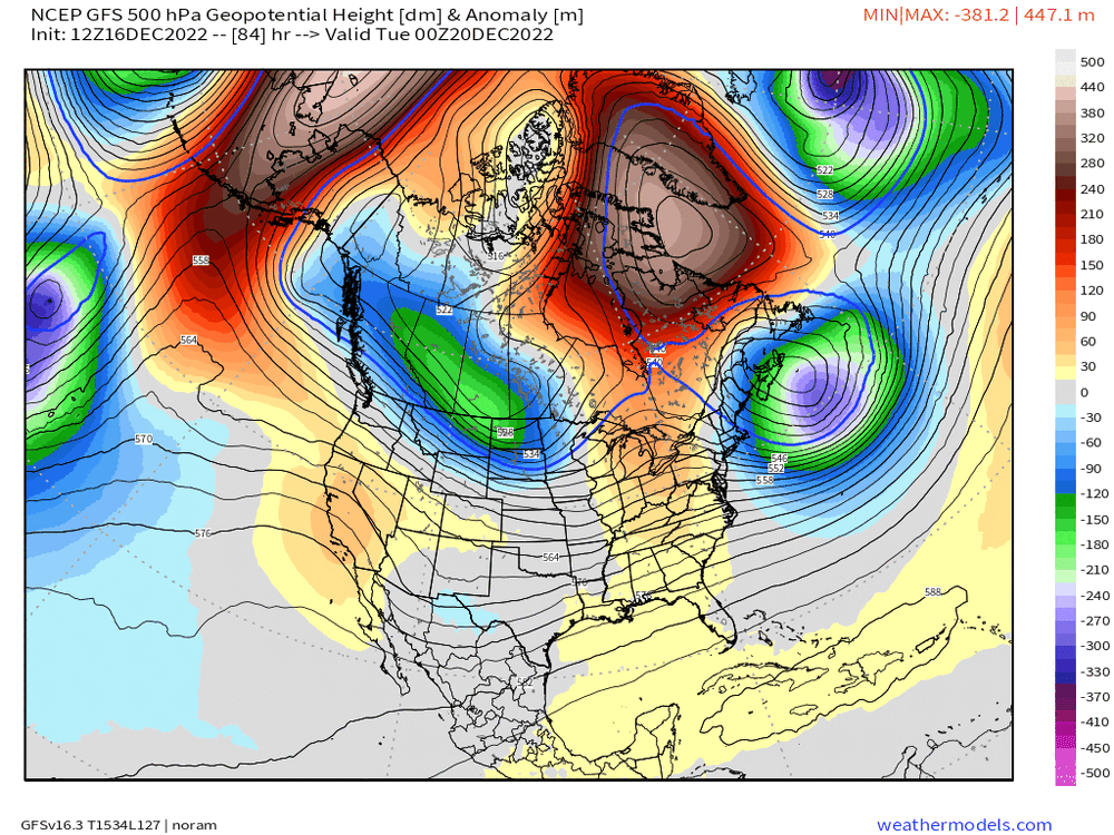
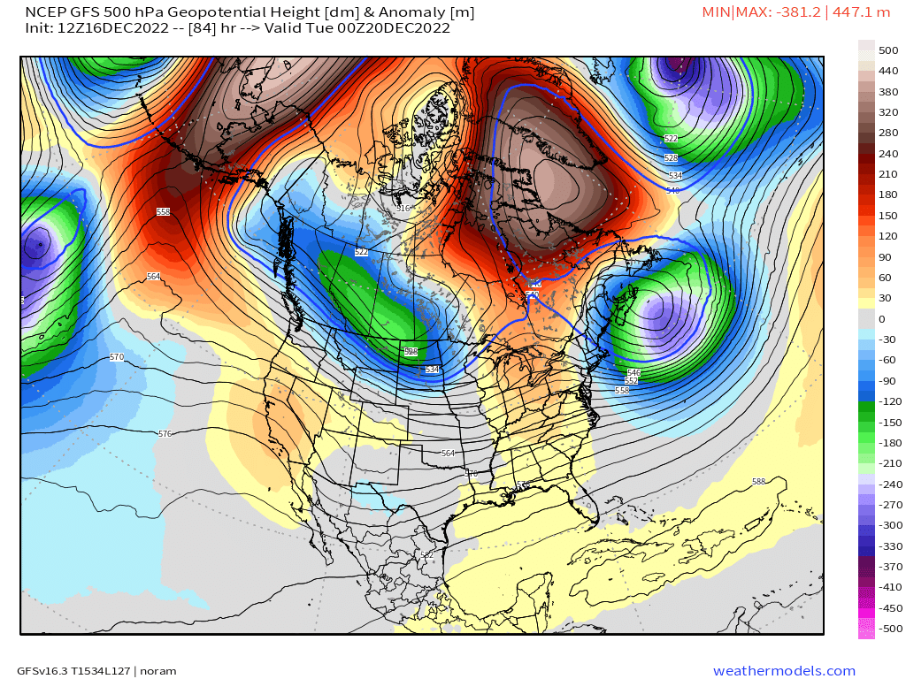
Well one of the sets of models will be wrong....so by deifnition one of them will change a lot. GFS and NAM are similar while GGEM/Ukie are in the other camp. You can see the PV diving SE on the GFS/NAM....here's a comparison between GFS and GEM at 84 hours....you can cleary see the GFS is already sending that piece of PV off to the east and southeast.