ORH_wxman
-
Posts
93,095 -
Joined
-
Last visited
Content Type
Profiles
Blogs
Forums
American Weather
Media Demo
Store
Gallery
Everything posted by ORH_wxman
-
The event of the season - 2 days of hell!
ORH_wxman replied to Go Kart Mozart's topic in New England
-35 850 temps are pretty ridiculous...but I'd like to see other guidance a little colder at 925. Vday was colder at 925 than this one is even though 850 might be colder this time. Euro is like -31 at 925 while GFS/NAM are -28 or -29....and that can explain most of the difference. -
The event of the season - 2 days of hell!
ORH_wxman replied to Go Kart Mozart's topic in New England
Very similar to Vday 2016 cold shot...its in and out in like 24-30 hours. We were in the 50s on that Monday after being below zero Sunday morning. -
I think you mean Jan 2021....Jan 2022 was actually pretty cold.
-
The event of the season - 2 days of hell!
ORH_wxman replied to Go Kart Mozart's topic in New England
I am more inclined to believe the 2m temps in this type of setup vs the radiational cooling nights. The warmest 2m temps are the NAM right now which is your -5 to -6 range. GFS is maybe barely colder. Euro is wild with -10 or colder. I went back and looked at Vday 2016 and the Euro was going like -11 or -12 at BOS, so it ended up a couple degrees too cold, but not too far off. GFS was awful in that one....was like 5F too warm 36 hours out. Though I know the model has been upgraded since then. The MAV guidance was hilarious though....it was like 8-10F too warm. Too much climo on a 24 hour forecast i guess. -
The event of the season - 2 days of hell!
ORH_wxman replied to Go Kart Mozart's topic in New England
Won’t matter anyway. Wind will be too strong. It might decouple further west though like around SLK. Those would be the rad pits to look at Friday night/early Saturday morning. -
Yeah maybe. It’s weird though because we got pretty damned cold (with plenty of snow to boot) in the previous Niña base state from 2007-2013. But this one has definitely been different…a lot more +AO and when we do happen to get Atlantic blocking, it just hasn’t been able to trap PV underneath it in SE Canada ala years winters like 2010-2011. We’ve had two useless blocking episodes in the past 3 winters (one this past December and then another the first few weeks of January 2021…that one did reload at least and become useful in Feb 2021). But hopefully we can shake it up for next winter.
-
The event of the season - 2 days of hell!
ORH_wxman replied to Go Kart Mozart's topic in New England
-10 at Logan would be even colder than they got in 2016. I’ll take the over. Prob somewhere around -7 or -8. Still ridiculous for them. -
Yeah it’s been really noticeable the past few winters…really since the localized shift in 2019 it seems. The northeast has been an island of furnace since then while all the cold is dumping well west. You could argue it started after the 2014-15 winter, but we still had some good decently long periods of cold in ‘17-18 and ‘18-19. It’s like pulling teeth since then.
-
The event of the season - 2 days of hell!
ORH_wxman replied to Go Kart Mozart's topic in New England
Lol....it was uphill on the way, downhill way back. I was in middle school, so you only got a bus if you were pretty far away. I think it had to be at least 2 miles. -
The event of the season - 2 days of hell!
ORH_wxman replied to Go Kart Mozart's topic in New England
Yeah it’s definitely worse timing up north. Down here it doesn’t really get bad until afternoon and even then, the real nasty stuff is prob not until after sunset…esp down in CT. Up in NNE it could be just starting to get bad in morning but it’s full-on dangerous by the time school is out. -
The event of the season - 2 days of hell!
ORH_wxman replied to Go Kart Mozart's topic in New England
Or keep your gas stove pilot lit. We actually have both....woodstove in the back room and a gas fireplace insert in the living room, but as long as the pilot is lit, you can still turn it on with no power. Had to do that in the first March 2018 snowstorm when we were without power for 60 hours. Definitely essential to have another heating source if you are in any type of place that is prone to losing power. -
BDL was "only" +7.7 on the max temps. But they were like +11.5 on the min temps.
-
The event of the season - 2 days of hell!
ORH_wxman replied to Go Kart Mozart's topic in New England
Although they didn't cancel school for 1/16/94 or 2/6/95 down here....so maybe they just never will. I walked to school over a mile both of those outbreaks. edit: meant 1/19/94....1/16 was the first one that month which came on a weekend -
The event of the season - 2 days of hell!
ORH_wxman replied to Go Kart Mozart's topic in New England
If you don't cancel for this type of cold, then you will never cancel for any type of cold. It really doesn't get much worse than this from a historical perspective. But yeah, the morning not being as bad as afternoon/early evening might fool administrators into thinking it's not that bad. Down here, the timing is late enough I could see them having school...but anyone north into CNE/NNE, it gets bad pretty quickly on Friday. -
I don't think any site here broke the monthly record except ORH (by 0.1F), but that is kind of an asterisk because ORH has missing data for a few days in 1913 that would bring it past 2023 whereas the other sites do not. For BOS, it was 5th warmest. For BDL/HFD, it was 3rd warmest For PVD, it was it was 3rd warmest For MQE, it was 2nd warmest.
-
The event of the season - 2 days of hell!
ORH_wxman replied to Go Kart Mozart's topic in New England
Actually my period of record on climod is 1948....but MWN prob had another site before that. I know they go back further. -
The event of the season - 2 days of hell!
ORH_wxman replied to Go Kart Mozart's topic in New England
Oh I just posted above....is -50 the current record? I saw -46. -
The event of the season - 2 days of hell!
ORH_wxman replied to Go Kart Mozart's topic in New England
Wjat is the all-time lowest temps at MWN? I can see -46F in the Jan 1968 cold outbreak, but I don't see anything colder. But I could be missing one. -
The event of the season - 2 days of hell!
ORH_wxman replied to Go Kart Mozart's topic in New England
I'm more annoyed that the timing is going to rob us of a -30F high temp. -
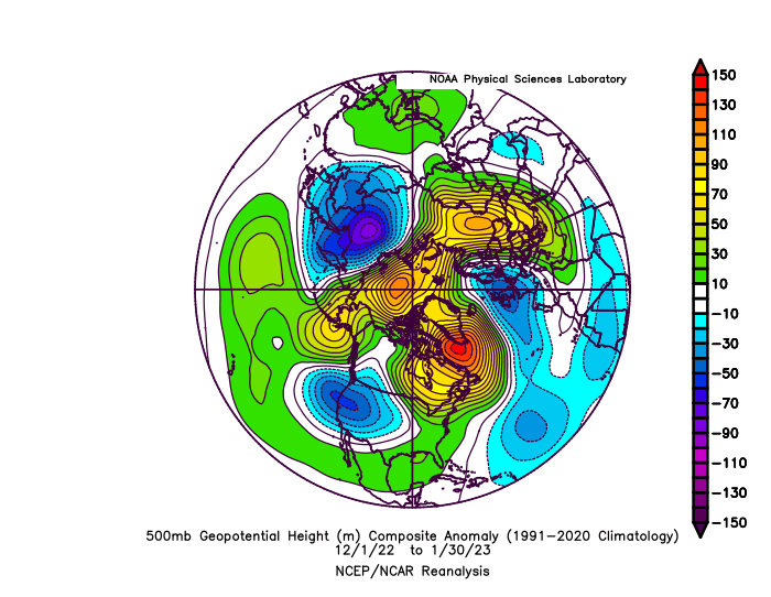
I don't see any SE ridge there at all. Heights are all well below normal over the east.
-
Yeah after 2015....we got this: 2015-16....total turd, but it was a super nino....didn't totally act like the prototypical super nino ala 1997-98 or 1982-83....but it was close enough in terms of our own sensible wx. Warmth and relatively low snow (epic low snow in NNE and far western SNE....eastern areas not to much)....though we did get the rogue 36 hour cold shot that winter. 2016-17....Above normal winter temp-wise, but also above normal snowfall. Had the first of the 70+ February warm spells. Though March went full winter shortly after. 2017-18....Pretty close to normal temps but very skewed on how that happened....arctic cold was plentiful in the first half of that winter from Dec 2017 through first 10 days of Jan 2018 and then we torched for the better part of the next 6 weeks including another 70+ mid.late February deal.....before winter stormed back in March with near-historic snow totals (ironically starting with a 37F rainstorm that busted a 6-10" snowfall forecast over the deeper interior). Snowfall ended up way above normal that winter. 2018-19.....Temps near normal that winter too. Maybe slightly above normal but no real mega torches like the previous two years. Snowfall below normal except right near coast which used 3/4/19 snowbomb to sneak above normal. 2019-20.....Temp above normal and snowfall below normal. Started off promising with that Dec 1-3, 2019 cutoff dropping 1-2 feet of snow over the interior and then the rest of the winter was mostly a total turd. No February 70+ torches, but it did have an early March (Mar 9-10th or so) torch of similar magnitude to those 2017 and 2018 warm spells. 2020-21.....This was prob the best winter since that 2017-18 snow juggernaut. Temps were a bit above normal, but we had a pretty prolific 3 weeks of snowfall between Jan 26th and mid February while avoiding any major melting. Most of interior SNE finished above normal for snowfall....coast got jobbed a bit...esp in that Feb 1, 2021 cutoff. 2021-22.....Last winter we've discussed plenty as it was more recent, but it was more frustrating than anything. We had an epic January tee'd up for us....the pitcher threw a hanging curveball and we popped it up instead of sending it over the Green Monster. That 1/17 stemwinder really cost us an epic month....basically a "how do you turn a KU into a front ender that gets washed away?".....that storm is your answer. Exotic full-phase that gives it a sharp left turn due north into the CT River valley....anything less and it's a KU blizzard. Obviously Boston and nearby got the epic blizzard 12 days later, but back in the interior, it was "merely" a great snowstorm....and wasn't quite enough to get rid of the 1/17 stench. We did get a good SWFE in late February, but then winter went out with a whimper in March. This winter needs no commentary in this post.....lol. We know what's happened.
-
Where we've been....yeah, December was unfortunate, but I guess that's payback for pulling 12"+ storms out of our ass in marginal patterns for years prior. Though I'm ready to stop rolling snake eyes...seems we've done it lot in the past 3-4 seasons. I remember you mused about how we were due to get screwed a bunch after that 2015 season....we may have been delayed a bit on the timing, but really since 2017-2018 winter, it's been rough. OBviously a few exceptions.
-
Pretty decent difference between GEFS and EPS too for mid-month....GEFS really aren't that warm...they do have what looks like a potential warm spell around Feb 16-17 but it doesn't last long. EPS seems to have a more robust warm signal and it lasts longer.
-
I would say this is the portion of winter so far where we got "bad luck"....we prob would end up colder/snowier a huge percent of the time if we roll the dice on this longwave pattern
-
Yes. You aren't going to be cold with this composite.