


ORH_wxman
-
Posts
93,110 -
Joined
-
Last visited
Content Type
Profiles
Blogs
Forums
American Weather
Media Demo
Store
Gallery
Everything posted by ORH_wxman
-
Actually noticed Jan 1913 is missing a few days of data at ORH....probably why they have a shot to break it and the others don't.
-
We might knock off January 1913 at ORH....we won't do it at BDL, PVD, BOS, or MQE though.
-
The one behind that.
-
The event of the season - 2 days of hell!
ORH_wxman replied to Go Kart Mozart's topic in New England
Those 2m temps are obscene. Almost all of SNE is double digits below 0F. -
The event of the season - 2 days of hell!
ORH_wxman replied to Go Kart Mozart's topic in New England
-35 is well into dangerous/causing problems territory....really you start seeing some car problems around -20F in my experience and it really ramps up colder than that. Of course, many people who live in rad pits in NNE will have batteries and other features that might add to the tolerance, but even those are gonna be tested by the time you get to -25 or -30F. -
Correct....even many of the "great winters" of the 1960s often had furiously stormy stretches surrounded by long drawn-out very boring stretches. (see 1968-1969 as one great example...1961-1962 is another).....the years like 1960-1961 are truly unicorns. I think the last winter that had all 4 major snow months at or above average is 2016-2017....of course, Feb 2017 had the snow blitz in the first half of the month and then touched 80 later that month, before we went back into the deep freeze that March. Getting all 4 months above climo snow though is very rare in and of itself.
-
I'm not talking lack of snow (yes anyone who lived through the dark years knows it can happen)...I was strictly speaking in terms of model performance. I know some had asked or speculated that CC was causing models to do things they normally wouldn't do...and the answer is no other than the data it ingests might be warmer than it was 20 years ago, but it's not going to change how the models calculate....physics is still physics and all of our thermodynamic and atmospheric dynamic equations are still the same regardless of whether temps are 1C warmer or not. So the models calculate 2m temps with lapse rates (adiabatic processes) and use diurnal effects to change them via diabatic heating/radiational cooling. (diabatic heating is mostly from the sun being up during the daylight hours) The models can "See" the cold shot right now fairly well because the PV is over Hudson Bay where sampling won't be as bad as in the arctic ocean or near the pole. The models might not fully be accurate in how far south the cold shot gets, but they know it's going to be intense because 850 temps are already below -30C in that PV and the whole thing intensifies before moving in which would make it even colder (hence the -40C readings on some of these runs).
-
Models are also continuously getting more skilled and errors getting smaller than previous versions of these models....so CC isn't causing model performance degradation. Or if it is, it's not enough to keep up with the other improvements in models, otherwise the model verification would not be improving like it has. 10-15 years ago, we had far more huge swings in model solutions inside of 3-4 days than we do now.
-
Models don't have any "climo" built in. The only aspect that would remotely affect it from a CC perspective is they have the atmospheric composition (how much CO2, etc) in there as constant, but this is updated every few years....so it's not going to cause any material affect on the model output on a 16 day solution. CO2 doesn't increase enough in a 16 day period to matter. Now, certain climate models that go out years might be affected, but usually those have built in emissions increases. The laws of physics and thermodynamics do not all of the sudden cease to exist because of CC. So there is no magic "climate change variable" to switch on in an NWP model. The data from January 30, 2023 is going to get ingested in the models and they are going to run using equations that obey the laws of physics/thermodynamics/atmospheric dynamics.
-
The event of the season - 2 days of hell!
ORH_wxman replied to Go Kart Mozart's topic in New England
The Vday 2016 cold shot was like that....very intense but very fast. -
The event of the season - 2 days of hell!
ORH_wxman replied to Go Kart Mozart's topic in New England
I wonder if some of the rad pits can go lunar Saturday night when the high is directly overhead. We obviously lose the epic mid-level and upper boundary layer cold by then, but sfc will be starting from a really low point and dead calm with snow cover....I'd think there could be some interesting readings in NNE. -
The event of the season - 2 days of hell!
ORH_wxman replied to Go Kart Mozart's topic in New England
GFS with -34C at BOS again and -42C in NNE at 850mb, lol -
The event of the season - 2 days of hell!
ORH_wxman replied to Go Kart Mozart's topic in New England
BDL hasn't hit -5F since 2019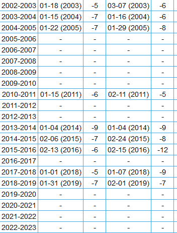
-
The event of the season - 2 days of hell!
ORH_wxman replied to Go Kart Mozart's topic in New England
You can find it in here on "First and last dates" on the single station options. https://xmacis.rcc-acis.org/ Then for snowfall, I chose 5" with >= qualifier and used Jul 1st and selected "Seasonal" Here's BDL for 5 inch snowfalls (they actually broke 5" in the 12/11 event): Only drawback for snowfall is that it is "single day" snowfall, so it wouldn't capture an event over multple days which happens all the time. You can sort of get around this by going to "Extremes" instead of first and last date, and then check the highest 2 day snowfall totals for any given season.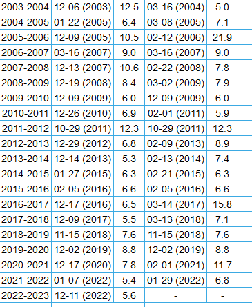
-
The event of the season - 2 days of hell!
ORH_wxman replied to Go Kart Mozart's topic in New England
ORH record low is only -4 that day...that's really weak for early Feb. -
We had two rounds of a transient pig....one early in the month (like first week)....and then another around Jan 15-18....but yeah, it hasn't been parked there for weeks like we typically see in torch patterns.
-
It looks like above normal after this next week, but that pattern shown on the ensembles seems like it would be prone to cold shots and probably some winter wx chances mixed in despite the overall being AN. The EPO ridge is still in place...it never reverts to an AK vortex.
-
The event of the season - 2 days of hell!
ORH_wxman replied to Go Kart Mozart's topic in New England
The snow cover line is not that far north of the pike either...it's not like this is advecting off of 200 miles of bare ground. -
Pretty sure that doesn’t qualify as “winter event”
-
-34C at BOS. Meh.
-
We had like 50F and rain 36 hours after that epic Feb 2016 cold shot. Hell, remember late Jan 94? I think we went from 0F to 50F in 12 hours. Actually I know you remember it because I recall you telling the story of that day’s progression…started with 4F needles and ended with steaming snow banks and fog.
-
You may be right. One of them had a trace and other was like 0.1” or something hilarious. Can’t remember which was which. I’ll have to look it up later.
-
Seems to happen a lot in the shit winters. Exception might be 2011-12…but even in that one we had a front ender in early March that dropped a few inches which ruined futility records in spots.
-
Though it would be kind of funny to see BOS get a high temp below 0F
-
Ugh…that better not verify unless we get some snow before it. Bare ground and -10 temps for many.


