ORH_wxman
-
Posts
93,095 -
Joined
-
Last visited
Content Type
Profiles
Blogs
Forums
American Weather
Media Demo
Store
Gallery
Everything posted by ORH_wxman
-
The event of the season - 2 days of hell!
ORH_wxman replied to Go Kart Mozart's topic in New England
Latest RAP and HRRR get -33C at 925 to BOS....that's insanity. Happens around midnight-ish. -
The event of the season - 2 days of hell!
ORH_wxman replied to Go Kart Mozart's topic in New England
I try to explain to people that CC warming will look a lot like a stock market chart....there is a trend up, but it's noisy. In a given month or even season, natural variability will outweigh CC by a lot. We can still get cold records....even all time monthly records....but they are just harder to get than warm records. -
The event of the season - 2 days of hell!
ORH_wxman replied to Go Kart Mozart's topic in New England
Logan airport hasn't hit -10F since Jan 1957....Vday 2016 barely missed at -9F. The Logan airport site has only ever hit -10F three times...-12F in Jan 1957, -14F in Feb 1943, and -11F in Dec 1942 -
The event of the season - 2 days of hell!
ORH_wxman replied to Go Kart Mozart's topic in New England
Down to 7.3F now...we've lost almost 4 degrees in the past 45 minutes. This is the big plunge right now....between now and about 03z. -
The event of the season - 2 days of hell!
ORH_wxman replied to Go Kart Mozart's topic in New England
This one is short-lived, but similar to Vday 2016, it is quite anomalous. 2016 produced the coldest readings at BOS and ORH since 1957. Not sure we quite match that this time, but can't rule it out. Wind chills will be top 3 in the past half century with this. -
The event of the season - 2 days of hell!
ORH_wxman replied to Go Kart Mozart's topic in New England
I've posted on the late 1940s/early 1950s winters in here before...those are some of the warmest years on record even if not quite as warm as the most recent warm winter...but esp up into SE NH and ME. Maine actually had 7 consecutive winters from '48-'49 through '54-'55 with temps +2 or higher than the long term avg....they haven't had a streak like that since....not even recently. -
The event of the season - 2 days of hell!
ORH_wxman replied to Go Kart Mozart's topic in New England
-
Yeah it basically turned into Labrador for about a month with the sea ice extending out from the shore many miles all along the MA shoreline.
-
The event of the season - 2 days of hell!
ORH_wxman replied to Go Kart Mozart's topic in New England
We've got -22 to -24C 925s about to move over us the next hour or so with surface temps still in the lower teens....that is really unstable. There's gonna be a lot of 50 spots. -
A 2015-esque freeze event prob is only once a decade or less. But Boston harbor and chunks of Cape Cod Bay and ACK sound do freeze at least a couple times a decade.
-
Harbor was totally frozen out to the islands east of Hull and Winthrop that winter. Almost all of Cape Cod Bay was frozen too and it was frozen out to MVY.
-
Yeah I’ve been joking around about it with Scott and Ray. The Ashland coop near me had 72.5” after February 18th that season after limping to about 23” up to that point. Talk about a big turnaround…lol. But all honesty, I do think that semi-colder look has been been advertised at least somewhat for a while…that EPO ridge never really went away…it ebbed and flowed a bit but having it there always gave the milder mid-month pattern a temporary feel to it. I do think there will be some winter storm threats late month into early March. But a bunch of crappy close calls and other variables that prevent snow wouldn’t surprise me this winter.
-
The event of the season - 2 days of hell!
ORH_wxman replied to Go Kart Mozart's topic in New England
Down another 2.5 to 12.1 in the past 60 minutes. -
Time to start honking Ray’s 1956 ending.
-
The event of the season - 2 days of hell!
ORH_wxman replied to Go Kart Mozart's topic in New England
Yeah as much as I love outdoors/mountains/lakes/etc....being that far from civilization full time with small kids doesn't exactly give me the warm fuzzies. -
EPS sig is strong for 2/12.

-
The event of the season - 2 days of hell!
ORH_wxman replied to Go Kart Mozart's topic in New England
You see how tight the 925mb gradient is over CNE/NNE right now...its tight over SNE too, but not as much as further north...that's where the big temp falls will start happening when that hits along with sun being down. You'll prob get 4-6F drops in one hour during that.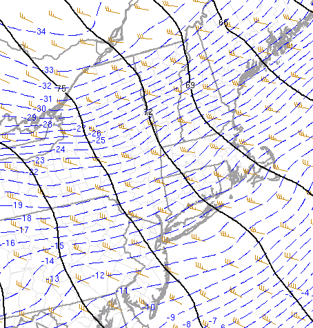
-
The event of the season - 2 days of hell!
ORH_wxman replied to Go Kart Mozart's topic in New England
Not the best place to raise a family, lol. Maybe a vacation cabin though. -
The event of the season - 2 days of hell!
ORH_wxman replied to Go Kart Mozart's topic in New England
The CAA at 925 also becomes more aggressive around now and into evening on guidance...so while solar/snow cover plays a role, it's not the entire story. The CAA had kind of a first initial pulse right with the FROPA, and then it has another acceleration later this afternoon and evening. -
The event of the season - 2 days of hell!
ORH_wxman replied to Go Kart Mozart's topic in New England
Steady drop since this post down back to 14.6F. Should be a pretty steady drop now being past 2pm and sun is starting to get pretty low in the sky. -
I haven't even taken mine out of the shed....I usually have it chained to my deck all winter, but it's still sitting in the shed from the warm season. We'll see if the 2/11-2/12 threat turns into anything interesting. Right now, it's got potential, but it's all about timing. If timing is slightly off like we see on the Euro, then it's mostly rain or nothing.
-
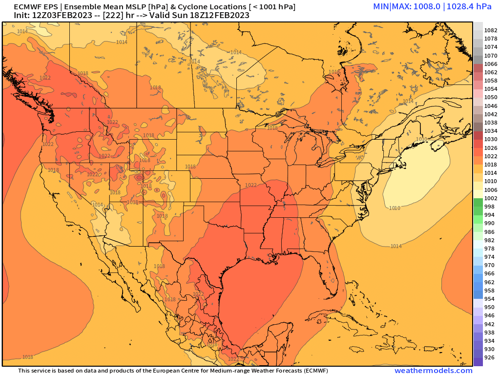
Euro looking pretty interesting at D7....brewing something up to the southwest with a decent high nosing in. Seems like all guidance have something there that may be trackable. Obviously no reason to take it seriously for winter wx until we are closer, but there is a reason to keep an eye on guidance at least.
-
The event of the season - 2 days of hell!
ORH_wxman replied to Go Kart Mozart's topic in New England
Got down to 14.6 but now back to 16.0...it's been doing that all day here since the sun got reasonably high in the sky (since about 10am)....2 steps down and 1 step up . -
Yeah SSTs in ENSO region stopped being relevant around New Years...the lag puts it well into March at that point. Hopefully prolonged Nina into spring means we'll have a warm spring.
-
The event of the season - 2 days of hell!
ORH_wxman replied to Go Kart Mozart's topic in New England
It's an amazing upslope spot but kind of goes undetected without a coop there these days. They had almost 300 inches in 2000-2001