ORH_wxman
-
Posts
93,092 -
Joined
-
Last visited
Content Type
Profiles
Blogs
Forums
American Weather
Media Demo
Store
Gallery
Everything posted by ORH_wxman
-
That’s actually pretty impressive verification from 300+ hours. Nailed the N PAC decently and the western ridge. Missed on the Atlantic side though.

-
Yeah but to be fair, when we were tracking it on the weeklies, it was mostly near or after Xmas…and it actually seems like that is going to verify now since we’re already seeing the seeds of the pattern creeping inside D10. There were a few brief times where it looked like we could get a big -NAO to offset some of the bad PAC but it was mostly transient…we did sneak in a semi-favorable look in the first week of December but wave-spacing hurt us in SNE and only the south shore of MA got that 1-3” event.
-
Yeah I think there’s a chance for that one but not a great one. But it’s been trending better the last couple of cycles so if that keeps up then maybe we have something to track for real by this weekend. Ensembles have been sharpening the ridge near Hudson Bay.
-
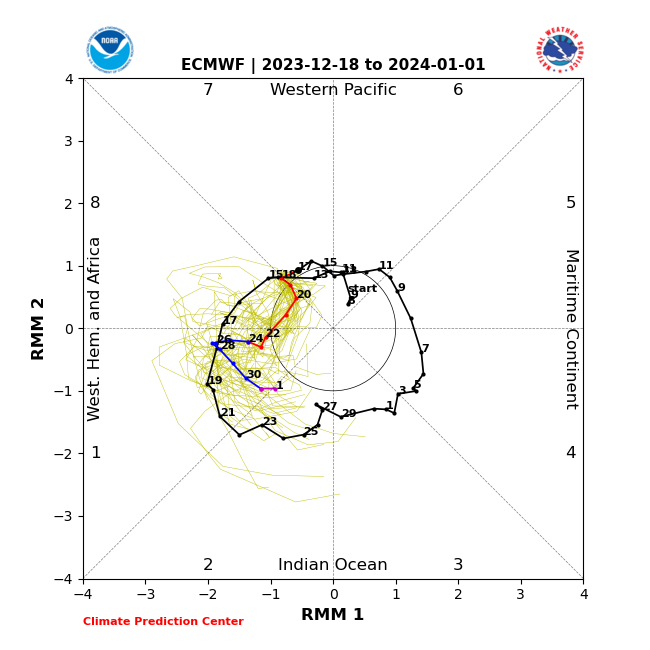
I wouldn't be all that critical of those who used that type of defensible reasoning....but most of the posts aren't of that substance. In fact, most of the posts don't have much substance at all other than it's not going to snow...sometimes with reference to "we heard this last December", as if that is really a logical scientific argument. QGomega (who can make a decent post when he wants to) did mention the MJO the other day claiming we would stall in phase 7, but that argument isn't really going to be all that viable now since we clearly didn't stall there and we're actually already exiting out of phase 7.
-
Sunday, December 17 - Monday, December 18, 2023 Storm
ORH_wxman replied to weatherwiz's topic in New England
The sustained winds were more impressive than the gusts here.....we had some good gusts, but it was the constant 30-40mph sustained bursts that would last a long time. -
I don't (and most mets wouldn't) consider this to be persistence forecasting....you're using meteorological variables (tropical convection in the Pacific or IO) to form the basis of a forecast. That's actual forecasting....persistence is when you ignore any other empirical evidence and only go based off of what has happened recently. We actually had a forecast competition in the meteorology department at Cornell (and many other met schools have them too) where you had to forecast the weather over the next 3 days. There was a few automated contestants....a couple of them were just MOS output and then there was one called "persistence"....I think it took the mean of the last few days to forecast the coming days. It consistently came in last place.
-
Yes. For some reason that broke a lot of people...acting like that never happened before. I could rattle off a bunch of great longwave looks that failed to produce.
-
Yes, but when it doesn't work, it's a spectacular failure which is why it's such a bad way to forecast. Persistence is typically going to involve periods of docile weather because stormy weather doesn't typically last weeks on end. So essentially, the strengths of persistence forecasting are doing very well when the weather is generally quiet....but it fails the most when the weather changes and becomes very unsettled, exactly the time when you want to have an accurate forecast out there. I don't think I ever met a skilled forecaster who said they incorporate a lot of persistence into their forecasts. It's one thing to sort of hedge toward climo in many instances due to familiarity with patterns and how they affect local sensible wx, but that is definitely not the same as a mindless drone "persistence" forecast. The irony in here over the persistence argument is that New England winters typically feature decent snow, so in this case, you can't even really claim persistence is hedging toward climo for the crowd in here that keeps saying it's not going to snow.
-
The old saying is persistence fails when the stakes are the highest. Besides, this current pattern doesn't look anything like last year so the only "persistence" is the sensible wx of little to no snow and AN temps. There's no reason to actually stick with persistence if evidence is starting to mount that it's coming to an end.
-
It was good to see the GEFS almost completely cave to the EPS the last couple runs in the 11-15 days. If you recall a couple days ago when the GEFS didn’t look awful but they weren’t nearly as good-looking as the EPS. Now they look like the EPS.
-
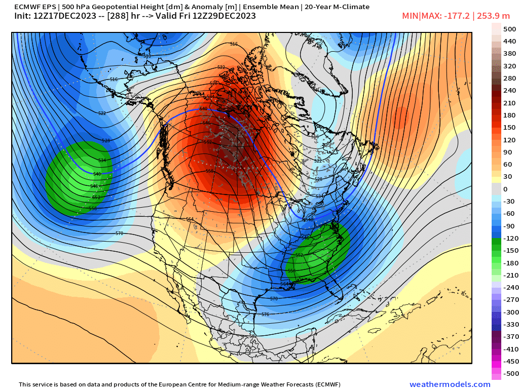
GEM is building in that high too for the 12/27 system....GEFS are starting to bite too, so we'll see if other guidance suites like the EPS try to come around on that potential threat.
-
Sunday, December 17 - Monday, December 18, 2023 Storm
ORH_wxman replied to weatherwiz's topic in New England
I’m more impressed with BOS sustained winds at 43 knots than the 59 knot gust. -
Because feels and vibes trump science. In all seriousness, the OP run sort of showed the same pattern…it’s just that you have to get rid of the cutter first in 12/27-28 on the OP run but it has a super amped meridional pattern over North America.
-
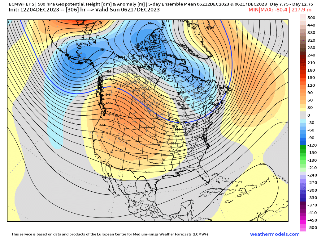
Retrograding low in the N PAC there. That’s a really legit good look versus the marginal look of the GEFS.
-
This is actually a pretty damned meridional pattern on the EPS today for 12/29….I think this is how we’d sneak something in prior to New Years
-
Yeah I thought we’d prob sneak at least and advisory event i during the month of December…still could post-12/27 but it’s looking more precarious. That said, Nino Decembers can be hideous even in otherwise excellent winters. ‘57-58 was, 65-66 was, so was 14-15. I don’t think any of those Decembers had an event more than 2” in our area.
-
It’s serviceable but def not as good as the EPS imho.
-
I think most of January is going to be decent to perhaps very good. I’m sure we’ll have a period of crap but I wouldn’t expect it to last long. I’m also not a long range expert…and even experts are going to be wrong a LOT when it comes to LR. Early in the month should be our first reasonable period of a longwave pattern that actually is better than climo to produce snow events. I think interior will be favored initially because we’re still working with regular polar airmasses, but the coast should get more chances as we go deeper into winter. I think a lot of people forget (I know Scott doesn’t, lol) that the coast was an epic dumpster fire outside of 12/5 in 2002-2003 until February. Even the cold january they got mostly skunked while the interior was knee deep in pack from Xmas and 1/3-4 interior bombs. For the “what can go wrong” idea…well, we get a decent pattern but it just doesn’t produce a lot of snow…or the better pattern gets can-kicked another 2 weeks which honestly wouldn’t be that shocking in an El Niño .
-
Nobody ever used to post OP runs beyond D7-8 unless it showed something ridiculous like a cat 3 hurricane landfall or an epic blizzard and it was usually caveated with “just for fun”….I’m not sure why it’s become more common but it honestly degrades the discussion if it’s just posted and meant to be taken semi-seriously. OP runs are demonstrably way less accurate than an ensemble mean once you are out that far.
-
We don’t get solid airmasses in here until early January with this pattern progression. We can have some workable ones later this month though…interior prob favored of course. But they could also be cutters too. I’d keep expectations fairly low for now but right now, I’d have higher expectations for the first half of January.
-
Yeah I think there’s a strong case to be made that we should get some legit threats in the Dec 28-Jan 10 range…if that period breaks down into a shit pattern, then it might be time to worry.
-
Yeah this part I quoted here is what drives me nuts. A warmer climate does start to load the dice against you for cold/snow…especially in very marginal snow climates like the mid-Atlantic or southern states from southern plains to TN valley but from the GL to New England it’s going to be a LOT noisier and the increased moisture may actually help with increasing snowfall even if temps aren’t as cold because you had more wiggle room to begin with. Attribution studies are inherently very difficult and even the ones that find attribution often get misrepresented in press releases and media…like I’ll see a headline that says “Boston winters may average less than half of their current snow by 2050”, but then I open the link to the paper (if they even bother to link it in the article which has become more and more rare) and I’ll see that it’s only the RCP 8.5 scenario that shows this which is the scenario that isn’t even realistic anymore (or barely a remote scenario if we dropped all green energy and went to coal everywhere)…so yeah, technically that is correct, but why is it a leading headline since it’s not going to happen like that? More realistic attribution studies usually might find a correlation but it’s low. Something like “this pattern may occur 1 out of 50 years instead of 1 out of 100 back in the 20th century”…but often that gets phrased as “this is twice as likely!”…while mathematically correct, that phrasing is intended to make a very rare event sound common instead of just slightly less rare.
-
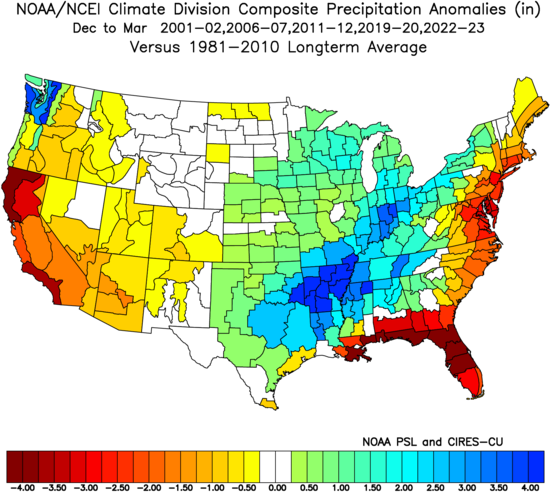
Most of our brutal snow winters have been dry too but that isn’t always the case. But just to show…here’s the 5 lowest snow winters for Boston since 2000
-
Most of the CC doomsdayers when it comes to winter don’t have a very good knowledge of historical variability. You mentioned the 1930s-1950s and that was actually a pretty brutal period too in New England for snow lovers…the early 1950s were actually unmatched for a LONG time in terms of warmth and low snow...esp in NNE. It doesn’t require rejecting CC to understand that natural variability works on top of it. We’ve had these discussion in here before many times but you can only lead the horse to water…. I think I posted some maps on how the northern plains/N Rockies were the fastest warming region in winter for a few decades in the late 20th century…now those areas have actually had an negative trend (cooling) since the 1990s in winter while the northeast and SE Canada have had the strongest warming trend during that time. Temporal and spacial difference are going to happen and it wouldn’t be surprising to see another period of colder/snowier winters in the NE after this recent period of warmer/less snowy winters. Maybe this year will help turn the tables since El Niño can help shake up the Pacific pattern.
-
If we got a 14-15 repeat, it would be impossible to not call it a great winter if you like cold/snow. Or a 57-58. Both were near shutouts in December around here.