


ORH_wxman
-
Posts
93,110 -
Joined
-
Last visited
Content Type
Profiles
Blogs
Forums
American Weather
Media Demo
Store
Gallery
Everything posted by ORH_wxman
-
We want to see it between 8-12 tonight. It wouldn’t be happening now.
-
No you want to see solid precip creeping into the border counties of Ohio with WV. Doesn’t even need to be well into the state, but if it is, then we’re def getting destroyed.
-
Doesn't help us a whole lot out east this run, but I'm hoping this translates as we get closer...it was noticeable back in PA.
-
21z RAP coming in with a solid bump NW so far through 12 hours compared to 20z.
-
Yeah I've been expecting S trends but these aren't as bad as I was thinking....that's still a big fronto sig from like HFD/Kevin over to BOS....the trends are concerning, but there's def still a good banding potential there on that run.
-
I actually thought the 18z RGEM would be a lot worse.... Haven't seen any major moves on the 20z HRRR/RAP. 19z looked a little better than 18z, but 20z is pretty much the same...might have been just a shade better on the HRRR but we're talking such small differences.
-
That's just the super hi-res version of the RGEM. Thats the 12z run...I'd expect 18z to be pretty ugly for the pike crowd.
-
19z RAP ticked back NW a little bit compared to the 18z run. 19z HRRR doesn't look like it moved much at all. Gonna keep an eye on these post-18z runs. I don't think you should expect anything other than S trends with other 18z guidance that hasn't come out yet.
-
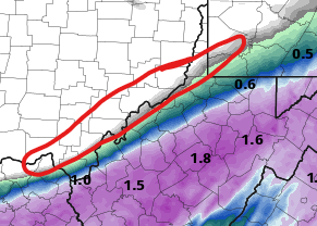
If you want to follow something definitive upstream that will tell us whether the latest southern guidance is more correct, look at the radar along the Ohio River in SE Ohio tonight between 8pm-midnight....almost all of the guidance that crushes SNE gets good precip just over the Ohio river into the border counties of SE Ohio....the crappy runs keep it in West Virginia and basically completely whiff those Ohio counties. It ends up making a big difference downstream later on for us as the difference gets magnified....
-
Euro uses more up-to-date data than the earlier 12z runs....part of its data assimilation process is that it can use ground truth to "Check" some of the 2z ingest. I'm not a total expert on the data assimilation for NWP guidance, but I do remember reading that was an advantage the Euro had several years ago.
-
I don't think it will be all that interesting...it's going to go way south because the 18z RAP/HRRR already did that....the 18z cycles clearly have data ingested that say this is going to be way south. The more interesting part of me is going to be if we see the mesos try and tick back N on the post-18z runs.
-
This is prob what Feb 1989 would have looked like if we had the same frequency of model output back then.
-
the 18z HRRR is already a solid 30 miles south of the 15z run at 14 hours.
-
What is concerning isn't just the south trend in and of itself...it's also causing the dynamics to be weaker because you're not curling up that vort as much like we see when you get just a tiny bit of northern stream insert.
-
It looks like it is going to....coming in flatter on 18z so far. Not sure it will be as bad as the RAP, but the trend will be south this run.
-
18z RAP gets no precip to the pike. 0.1" of QPF to about HFD.
-
1/27/11 was similar up here (down by you, it was always going to be a big storm)....models went from a huge hit around 48h out to almost a total whiff 24h out but then in the final 12 hours, they blitzed back NW....at first, the old RUC had us getting crushed at 12-18 hours out, but we sort of discounted it as RUC amped bias beyond 6 hours, but then it kept showing it and finally the 18z NAM came in and jumped way NW. Most of SNE got like 12-18" from that one
-
This type of model performance this close to the event is almost unheard of in the past 5-10 years...even 15 years ago it was not common.
-
Ukie is almost a copy....
-
Not verbatim, but it's still concerning if there's even a compromise between it and other guidance.
-
This is one of the worst modeled systems i can remember in the past 10-15 years. Guidance has been really bad with this. Reminds me a little of the 1/27/11 event in that respect, but that one actually started coming back in the final 12 hours....this one better reverse course soon if it wants to match that progression.
-
Dude was locking in the ICON a couple days ago while calling everyone weenies when it had mostly rain south of rt 2.....utter embarrassment.
-
Both NAMs, ICON and HREF all give you double digits. GFS technically a little south, but you'd prob score 10"+ on that run too given the ML fronto look. You may miss the goods if this ticks a little south, but there is guidance that hits you hard at 12z.
-
Temps or are you worried about the best stuff going south? Seems like if you end up with an inch of QPF but 925mb is like -3C during the bulk of the good stuff, you'll pound paste.
-
Your elevation there in "northern" SW CT might be a great spot for one of the highest totals.



