

ORH_wxman
-
Posts
93,092 -
Joined
-
Last visited
Content Type
Profiles
Blogs
Forums
American Weather
Media Demo
Store
Gallery
Everything posted by ORH_wxman
-
Saturday February 16th - Another CT/ Cape special?
ORH_wxman replied to Sey-Mour Snow's topic in New England
ha…TTs of 55. Could get thundersnow on that sounding. Nothing else supports that look though so I’m expecting it to disappear as we get closer. -
It was a Flop... February 2024 Disco. Thread
ORH_wxman replied to Prismshine Productions's topic in New England
That def a bit more interesting with a ULL that deep on the GFS. That threat is still a long ways out so there is time for it to look a lot more threatening. Keeping expectations low but there is longwave support for something. -
Saturday February 16th - Another CT/ Cape special?
ORH_wxman replied to Sey-Mour Snow's topic in New England
GFS looks good for an inch or two for southern half of CT…there’s actually a decent little area of H7 fronto that clips LI and the south coast so can’t rule out a little band that drops 3”+ lollis if that ends up verifying. -
It was a Flop... February 2024 Disco. Thread
ORH_wxman replied to Prismshine Productions's topic in New England
You are not going to have to worry about arctic Coke lines in the 2/24 threat. That is a pretty marginal airmass imho. Decent chance we get rain out of it too. -
It was a Flop... February 2024 Disco. Thread
ORH_wxman replied to Prismshine Productions's topic in New England
3k gives far SW CT a couple inches tomorrow AM. Def worth watching there. -
It was a Flop... February 2024 Disco. Thread
ORH_wxman replied to Prismshine Productions's topic in New England
“Sneaky pattern for NNE/upslope areas” i mentioned yesterday. There’s more in the pipeline up there over the next few days. Another clipper there Sunday/Sunday night and then maybe a weak disturbance wed/Thu -
It was a Flop... February 2024 Disco. Thread
ORH_wxman replied to Prismshine Productions's topic in New England
There’s def some big hits on the EPS individual members but there’s plenty of northing too and a few rain events as well. Hopefully that threat becomes a bit more coherent. -
It was a Flop... February 2024 Disco. Thread
ORH_wxman replied to Prismshine Productions's topic in New England
Wow nice. Maybe a quarter inch in Holliston. We got one of the thinnest parts of the band…typical. -
It was a Flop... February 2024 Disco. Thread
ORH_wxman replied to Prismshine Productions's topic in New England
That’s like an hour in this winter. Beggars can’t be choosers. -
It was a Flop... February 2024 Disco. Thread
ORH_wxman replied to Prismshine Productions's topic in New England
Yeah the band looks nice but it’s moving. Was thinking a few spots may get 2” but that looks like a heavy lift pike south. Looks a little healthier up north of rt 2. -
It was a Flop... February 2024 Disco. Thread
ORH_wxman replied to Prismshine Productions's topic in New England
The problem is mechanics in the flow. It’s a rounded trough base and fast flow. That is plenty to “keep it from coming north”. If we can sharpen the shortwave with a slightly stronger vort, then that’s one way, but otherwise most of us are prob just getting some flakes and maybe a dusting. I’d def keep an eye on it down in southern zones though. -
It was a Flop... February 2024 Disco. Thread
ORH_wxman replied to Prismshine Productions's topic in New England
Good thing the snow tonight isn’t about 4-5 hours earlier. That would’ve been a disaster for evening commute. It’s not a lot of snow but it looks like it could rip for an hour or two which will def mess up the roads. -
It was a Flop... February 2024 Disco. Thread
ORH_wxman replied to Prismshine Productions's topic in New England
It’s got steady light snow at least into southern half of CT. It does have measurable up into MA but a bit more skeptical of that actually being more than just flurries or a few snow showers. If it ticks north again, then it would be worthy of a deeper look. -
It was a Flop... February 2024 Disco. Thread
ORH_wxman replied to Prismshine Productions's topic in New England
The trough position is pretty favorable for our area but the base it just a bit rounder/diffuse. If we sharpen that little vort near Philly a bit more, then there could be a decent stripe of moderate snows over southern CT/RI. Wouldn’t take much. I’d need more up this way…but even as is, I wouldn’t be surprised if there was a steady light mood snow across a chunk of the area on Saturday predawn/Saturday morning.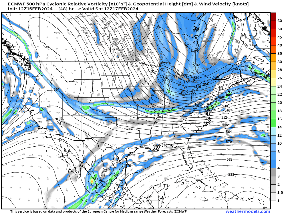
-
It was a Flop... February 2024 Disco. Thread
ORH_wxman replied to Prismshine Productions's topic in New England
Euro getting a little more interesting for Saturday in southern zones. -
It was a Flop... February 2024 Disco. Thread
ORH_wxman replied to Prismshine Productions's topic in New England
Yeah I’d agree on that. We haven’t had a lot of dryness out there since the early 2010s. We had some good heat domes move over the top those years. I think ORH got 96 one of those years. (Maybe 2011) Certainly a dry winter helps start the process since you basically get very little melting runoff in the spring with those warm/dry winters. -
It was a Flop... February 2024 Disco. Thread
ORH_wxman replied to Prismshine Productions's topic in New England
We need a central US drought to help give us a good source region for extreme heat on max temps in the summer…and then get the pattern to evolve in a manner where it advects into us instead of getting shunted south of NYC. I don’t think we’ve had a good one a while…we’ve been abnormally wet over the CONUS -
It was a Flop... February 2024 Disco. Thread
ORH_wxman replied to Prismshine Productions's topic in New England
Semi interesting for south coast. Esp in CT. It’s be surprised if we got much of anything except a few flakes further north. Maybe your area can grab a dusting. Tonight is more interesting for most of us. -
It was a Flop... February 2024 Disco. Thread
ORH_wxman replied to Prismshine Productions's topic in New England
I mean, the longwave pattern is ripe during that time which is why we were interested it in even back to last week. Sucks we can’t get any timing right. But that’s how you go from a mere subpar winter to a rat. You miss on your windows of opportunity. -
It was a Flop... February 2024 Disco. Thread
ORH_wxman replied to Prismshine Productions's topic in New England
Yeah I just posted that after you…there’s just a weak wave down south…I was hoping to see something stronger in that period. A northern stream insert would’ve helped too. -
It was a Flop... February 2024 Disco. Thread
ORH_wxman replied to Prismshine Productions's topic in New England
What sucks for the 2/20 period is that the southern stream temporarily decided to go quite when we have the big PV sitting just to our north. In El Niño, once you have a PV to our north, you often get the big dog when the STJ amplifies into it…but instead, we have very little southern stream action until a few days later…which may produce something in the 2/23-24 timeframe but it’s more precarious by that point. -
It was a Flop... February 2024 Disco. Thread
ORH_wxman replied to Prismshine Productions's topic in New England
Glad we don’t live there… -
It was a Flop... February 2024 Disco. Thread
ORH_wxman replied to Prismshine Productions's topic in New England
It might rip for like 60-90 minutes this evening. Someone yesterday said it’s almost like a squall line that comes through and that isn’t a bad comparison. It’s a pretty nice band of snow that lasts 1-2 hours and has excellent snow growth. A quick 1-2” seems likely for many. Can’t rule out a 3” lolli…more likely north than south. -
It was a Flop... February 2024 Disco. Thread
ORH_wxman replied to Prismshine Productions's topic in New England
I don’t think the reaction would be that negative at this point. Maybe if it happened in January but in late Feb/early Mar, many peeps would prob just welcome 60s/70s….tho we know it won’t be a segway into warm spring around here. It’ll flip back to 35-55F and east flow for the better part of the following 6 weeks. -
It was a Flop... February 2024 Disco. Thread
ORH_wxman replied to Prismshine Productions's topic in New England
Let’s go 07-08 next winter


