

ORH_wxman
-
Posts
93,099 -
Joined
-
Last visited
Content Type
Profiles
Blogs
Forums
American Weather
Media Demo
Store
Gallery
Everything posted by ORH_wxman
-
Significant Miller B Nor'easter watch, Apr 3rd-4th
ORH_wxman replied to Typhoon Tip's topic in New England
Man what a pelting the NAM is over a lot of MA. Wish we could keep that mid-level warm front south longer but it doesn’t seem to want to happen except on a few rogue model runs. Western Maine is going to get crushed. Doesn’t really seem to matter the exact solution, they are getting 18-30” every run. Some a little close to 30 and others closer to 18 but always crushed. -
Significant Miller B Nor'easter watch, Apr 3rd-4th
ORH_wxman replied to Typhoon Tip's topic in New England
Was also snowier N of pike. Esp up by Rt 2 and over to Ray's hood. -
Significant Miller B Nor'easter watch, Apr 3rd-4th
ORH_wxman replied to Typhoon Tip's topic in New England
Yes. It’s subtle but we really need the height field to try and “open up” south of New England. That trend started yesterday after most guidance had relegated the system pretty much a total non-event south of monadnocks from the tempest they showed 2-3 days prior…but it’s a precarious trend that could easily snap back. And it’s possible we may not even know the fate of that idea until very close to go-time. As both of us know, convection can wreak havoc on those subtle height field differences and cause the mid-level warm front to stay further south than modeled. Or the reverse might happen and it goes further north than progged. -
Significant Miller B Nor'easter watch, Apr 3rd-4th
ORH_wxman replied to Typhoon Tip's topic in New England
As soon as I looped H5 (I usually do that first) I knew it was going to be slightly worse since it wasn’t bulging out the H5 heights quite as well to the east as 06z was. That, in turn, pushes the midlevel warmth and dryslot further north. It’s crucial we keep the H7 front south of us through 12z Thursday if we want warning criteria snowfall. -
Significant Miller B Nor'easter watch, Apr 3rd-4th
ORH_wxman replied to Typhoon Tip's topic in New England
12z euro looks a bit warmer than 06z. Took a step back. Gonna have to sweat it out apparently in the N MA/S NH zone. -
Significant Miller B Nor'easter watch, Apr 3rd-4th
ORH_wxman replied to Typhoon Tip's topic in New England
That sounding honestly looks like it would be in the upper 20s range at the sfc if you have heavy lift. You’re pulling -5C not very far off the deck there. But the million dollar question remains is how organized can we keep the heavy lift? Given the relatively late nature of the secondary development and the ULL remaining very strong to our west, I worry about conveyor mechanics getting out of sync. But this subtle trend of “bulging” out the H5 low to the east and lowering heights there is helping over the past few cycles. -
Significant Miller B Nor'easter watch, Apr 3rd-4th
ORH_wxman replied to Typhoon Tip's topic in New England
I think omega/lift will have a lot to do with it too. If we get a very good area of consolidated strong lift, the soundings are going to want to flash colder. But if we keep things a little more banded and slightly less organized or the lift just isn’t quite as intense, it’s prob a lot more sleet. -
Significant Miller B Nor'easter watch, Apr 3rd-4th
ORH_wxman replied to Typhoon Tip's topic in New England
Yes. It’s pretty cold in the 925 layer around -3ish Heres the sounding at 06z tomorrow night near you while GFS is pounding…you can see how once off the immediate surface, you’re comfortably below freezing so this isn’t going to be a scenario where you have slush balls falling through an isothermal layer 3000 feet thick and not sticking well. If the rate are good, accumulations will easily be 10:1 on that type of sounding…you might even pull 15:1 for a while with that cross hair sig, but I’d want to see all the models agree on that before taking it too seriously.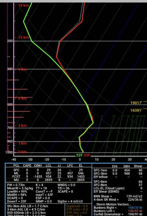
-
Significant Miller B Nor'easter watch, Apr 3rd-4th
ORH_wxman replied to Typhoon Tip's topic in New England
Yeah it doesn't need much to get BOS into legit snow. What a tease. -
Significant Miller B Nor'easter watch, Apr 3rd-4th
ORH_wxman replied to Typhoon Tip's topic in New England
12z GFS is pretty interesting too for areas like BED over to 495 belt near Westford/Ayer where Tip is. -
Significant Miller B Nor'easter watch, Apr 3rd-4th
ORH_wxman replied to Typhoon Tip's topic in New England
Ray crushed on 12z GFS....really smoked that NH border region overnight tomorrow night and early Thu. -
Significant Miller B Nor'easter watch, Apr 3rd-4th
ORH_wxman replied to Typhoon Tip's topic in New England
12z ICON is being run from Ray's computer. NE MA/SE NH jackpot. -
Significant Miller B Nor'easter watch, Apr 3rd-4th
ORH_wxman replied to Typhoon Tip's topic in New England
There's a ton of sleet initially up in the border region so it's still a huge question of when that can flip to snow. It's plausible it ends up as mostly sleet and then some nuisance snow after that. IF we cool it one more tick, then I think it's gung ho near MA/NH border, but there's reason to stay cautious at the moment. I do think it won't be zero snow....there will likely at least be a few inches of crud at minimum. -
Significant Miller B Nor'easter watch, Apr 3rd-4th
ORH_wxman replied to Typhoon Tip's topic in New England
I think it can accumulate during the day ok with these soundings....but the key is keeping H6-7 saturated and getting decent rates. If it goes slotty with light rates, then it won't matter. But if you're going moderate to heavy snow at noontime with 850 temps in the -9C range and 925s in the -4C range, it's pretty hard to not accumulate. But the key is not slotting aloft....we want to keep that H7 WF to the south of us. Those 0.15 to 0.2" QPF in 3 hours won't cut it...need over 0.25" every 3 hours. -
Significant Miller B Nor'easter watch, Apr 3rd-4th
ORH_wxman replied to Typhoon Tip's topic in New England
Shows ORH hills sub-freezing at the sfc after midnight tomorrow night through Thu morning. Pretty good lapse rates from Sfc to 850ish, so any heavy precip is gonna prob get even lower elevations close to freezing from latent cooling....esp if we can replace the sleet with more snow, then latent cooling is even more efficient. -
Significant Miller B Nor'easter watch, Apr 3rd-4th
ORH_wxman replied to Typhoon Tip's topic in New England
There's no such thing as 33-34F in the DGZ.....gotta be more like -10C to get ice crystals, though as we've talked about before, in New England we can often get away with something like -6C or -7C because of all the salt nuclei in the air here being surrounded by the Atlantic on two sides and onshore flow. -
Significant Miller B Nor'easter watch, Apr 3rd-4th
ORH_wxman replied to Typhoon Tip's topic in New England
Loop the control run of the NMB and you can see how a bit further south with H7 makes a massive difference....that run prob gives Ray 20"+ of snow. http://www.meteo.psu.edu/ewall/ETAEAST_12z/etaloop.html -
Significant Miller B Nor'easter watch, Apr 3rd-4th
ORH_wxman replied to Typhoon Tip's topic in New England
If we can trend that H7 warm front a little south, then it gets way more interesting. Right now, still mostly a sleet bomb for a chunk of SNE with maybe some crappy snow up near Rt 2 and border region. -
Significant Miller B Nor'easter watch, Apr 3rd-4th
ORH_wxman replied to Typhoon Tip's topic in New England
Definitely continuing to trend colder. -
Significant Miller B Nor'easter watch, Apr 3rd-4th
ORH_wxman replied to Typhoon Tip's topic in New England
I’m pretty surprised there’s no watch for N ORH county. Guess they think it’s below 50% chance for 6”+ there. Might not be a large enough area too, but they may have to issue one if 12z stays on the colder side. -
Significant Miller B Nor'easter watch, Apr 3rd-4th
ORH_wxman replied to Typhoon Tip's topic in New England
If you get one more tick colder, then you’ll be in big snows I think…right now it’s still a lot of sleet contamination. -
Significant Miller B Nor'easter watch, Apr 3rd-4th
ORH_wxman replied to Typhoon Tip's topic in New England
06z Euro cooled. That’s pretty interesting now for N MA. -
Significant Miller B Nor'easter watch, Apr 3rd-4th
ORH_wxman replied to Typhoon Tip's topic in New England
Funny how euro might be the the warmest model now. Maybe the NAM is with it. Both are razor close though for northern SNE near rt 2 and NH border. -
Significant Miller B Nor'easter watch, Apr 3rd-4th
ORH_wxman replied to Typhoon Tip's topic in New England
Looks a bit warmer though through 54 compared to 18z. -
Significant Miller B Nor'easter watch, Apr 3rd-4th
ORH_wxman replied to Typhoon Tip's topic in New England
That’s a hell of a sleet storm for a good chunk of SNE on that run.

