ORH_wxman
-
Posts
93,099 -
Joined
-
Last visited
Content Type
Profiles
Blogs
Forums
American Weather
Media Demo
Store
Gallery
Everything posted by ORH_wxman
-
Do we know for a fact that we are getting more positively tilted troughs than usual in recent years? That would normally have a consequence of much drier sensible wx than normal, but that doesn't seem to fit the observed data.
-
December 2024 - Best look to an early December pattern in many a year!
ORH_wxman replied to FXWX's topic in New England
CC monitoring on a global or even national scale won't be affected by a few bad data points....there's so many of them that it amounts to a rounding error. But it will certainly affect the local climo records. When you have a 5 year period that is consistently calibrated 1-2F too warm, that would definitely be a problem. It will also affect model verification stats and could be an increasing problem for models that learn from observed data. If the models are accurate for their temps, but they "think" they are running 1-2F too cold versus reality when they actually aren't, that would be an issue too. -
Yeah maybe it doesn't work out....but then again, this current pattern is still only in its infancy. Something in the 1/10-1/15 range could easily pop. We had zero problems getting negatively tilted troughs on New Year's day.....
-
Gladly take a roll of the dice with this pattern at end of EPS.....slightly neg PNA with AK ridging and an east-based -NAO....at least suppression would be less of a worry.
-
New England Winter 2024-25 Bantering, Whining, and Sobbing Thread
ORH_wxman replied to klw's topic in New England
Yeah PSM is the same, but they should prob be a touch warmer than DAW....and DAW being 3-4F warmer than SFM seems a bit suspect. At least its not like 3-4F warmer than PSM now, lol. -
New England Winter 2024-25 Bantering, Whining, and Sobbing Thread
ORH_wxman replied to klw's topic in New England
Looks like it’s better…now ORH/BDL OTOH….
-
December 2024 - Best look to an early December pattern in many a year!
ORH_wxman replied to FXWX's topic in New England
Someone with an NWS tech background posted in here before and said if the ASOS thermometers are within 2F of calibration, it “passes”. I remember being astounded that it wasn’t an order of magnitude less than that. -
The “ineedsnow” intensity correction formula for falling snow is to just move the decimal one place to the right on reported visibility (or implied visibility from reported snow intensity).
-
December 2024 - Best look to an early December pattern in many a year!
ORH_wxman replied to FXWX's topic in New England
Solid 1-2F of separation. That’s so bad. The reason the graph is such a tell is that if differences in departures were due to random variance in weather conditions, you’d expect different stations to be warmer/colder outliers each time. But this is a consistent pattern which tells us the instrumentation is not correct. -
That's the really hard part...you need to keep the trends going and not have it revert back even partially.
-
GFS prob gets a C-1" deal into a chunk of CT.
-
Not very interesting up here....it might suck the CT crew back into the 1/6-7 threat though.
-
That was the final big storm threat of the season near the equinox....I remember it well. ORH only needed like 3-4 inches to break their all time March monthly snowfall record and they couldn't even do it. It's amazing how much snow we got that month despite two large busts (at least in the interior)....the other one was the Mar 2nd storm which was supposed to be a rain to heavy wet snow scenario over interior. Didn't flip until way too late.
-
December 2024 - Best look to an early December pattern in many a year!
ORH_wxman replied to FXWX's topic in New England
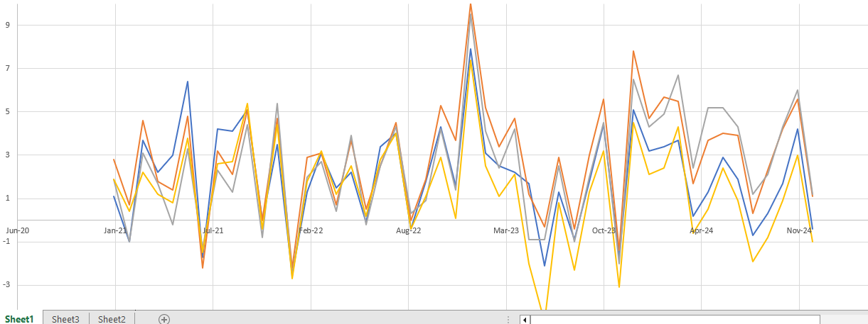
Graph of monthly departures since January 2021 for the 4 major first order BOX climo sites Legend: Blue = BOS Orange = ORH Purple = BDL Yellow = PVD Frankly, the last 2-3 years has been particularly embarrassing....absolute clown show from ORH and BDL slipped off the reservation too. PVD (we noted this a while ago too) started going cold as well in the other direction. You can see they fixed BOS sometime in late 2021...we had known they were too warm prior to that. All of these are going into the official database too to produce more normals once we get to 2030. @dendrite@CoastalWx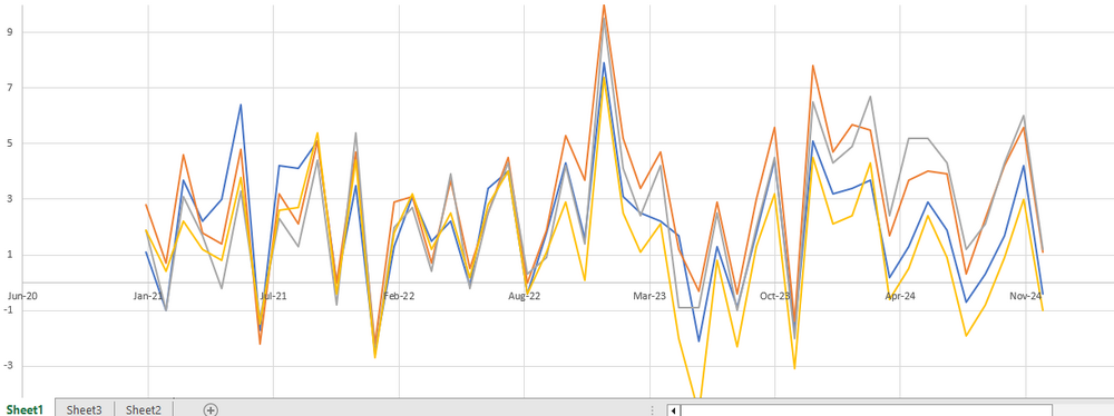
-
Almost looks like a neutral or even slightly negative PNA pattern developing beyond 1/15 to go with the -NAO.
-
Ptype issues.
-
Sygyzy storm…that was one of the few great ones in the 1980s. Jan 9187 was actually an epic month at ORH. Almost 50” of snow that month. That decade did have some good November and spring storms as well (April ‘82, 3/29/84, 4/28/87).
-
18z euro was a headfake. Glad I didn’t stay up and wait for 00z runs. Hopefully the stuff beyond 1/7 trends better in the coming days.
-
Feb 2013 had an Iceland block/ridge too. Just give us that one. Not asking too much.
-
The NAO configuration I like a lot more on that too. We talk about about different types of -NAOs but the version that backs up from Scandinavia through Iceland and Greenland tend to be extremely productive for us when we have western ridging. They don’t suffocate us as much.
-
Not biting yet despite the large move on 18z euro. Need to see a definitive move on 00z from most guidance. If we see that, then it gets interesting…esp south of pike.
-
We do get scraped by a 959mb low on 1/15. These runs aren’t afraid to put out absolute bombs. Just need to phase one properly for us.
-
December 2024 - Best look to an early December pattern in many a year!
ORH_wxman replied to FXWX's topic in New England
ORH is still running too high anyways. Been that way since 2020. Crazy that it’s almost 5 years worth of data now. I meant to put together a spreadsheet but haven’t done it yet…but now that we have all the months through the end of 2024, I may line up all the monthly anomalies for first order SNE sites and then graph them. That would be the ultimate tell. -
Yeah the 1/10 look has subtly improved today despite not getting an OP run tempest. Still could easily miss of course. Ensembles showed a bit more separation of the main shortwave and ambient lower heights near us and to our northeast. So hopefully we’re able to space something.
-
When the PV gets trapped in your back yard, EPO becomes less of a worry. Honestly looked like the ridge was rebuilding in the Bering near end of EPS anyway.