

baltosquid
-
Posts
531 -
Joined
-
Last visited
Content Type
Profiles
Blogs
Forums
American Weather
Media Demo
Store
Gallery
Posts posted by baltosquid
-
-
2 hours ago, stormtracker said:
You didn't tell us you just moved here. Welcome man.
6 long years here but I memory purge to cope I guess
-
We can’t get hurt by suppression twice in a row right? So… right where we want it.
-
If this weird boundary setup comes to pass, a good 24 hours of snow to get 2-4 sounds pretty.
-
 3
3
-
-
I don’t have a subscription anywhere right now to get it any quicker than TT, which won’t be for a bit unfortunately
-
1
-
-
Yeah at this point they’re not indicative but more showing that there is room to get a good op run, but whether that actually happens is suspect. Ops have been more stubborn.
-

further improvements to the 10:1 mean at 18z.
-
7
-
-
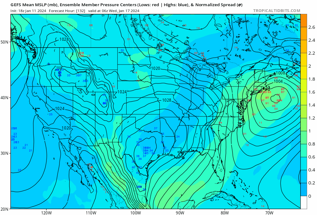
GEFS mean creeps the low further west at 18z
-
11
-
 1
1
-
-
Slight improvements continue today! NAM is fairytale stuff but if we keep moving with the trends towards an area wide 2-4, really hard to complain given the NBM had about that for days tbh.
-
1
-
-
Seems like 3km sets up the precip a bit further south but same idea. Can’t put too much stock in it, but I’d be curious to hear from pros what it would take to get that sort of sustained precip link between lows.
-
Excellent NAMming!
-
1
-
 1
1
-
-
Honestly check the GEFS snowfall trend over the last 24 hrs. It’s steadily improving. Upside is greatly reduced but maybe a 2-4 event is on the table if the passage of the cutter yields further improvements in this direction.
-
2
-
-
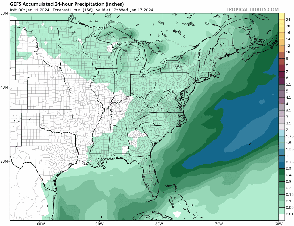
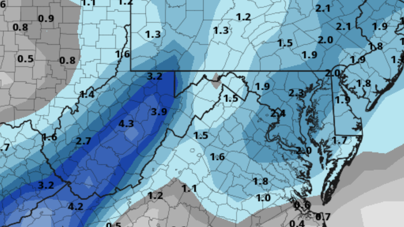
GEFS mean is 2 inches for the metros and their burbs, southern MD, and eastern shore if you’re west of the Delaware border longitude. Could be worse. Obviously it’s a smear of individual, less broad area of snowfall outcomes.
-
2
-
-
GEM has the pieces but they don’t consolidate like the GFS does.
-
ECMWF and its ensembles have always seemed to be very gradual movers relative to the GFS and especially the GEM. Not surprising it will take more than one run to reel it in if that is indeed in the cards. It’s a positive run, don’t let the doomium win just yet
-
EPS leaves me hopeful the bleed will be in our favor, but it was only a baby step.
-
2
-
-
Just put the bar at grass coverage. Something to help temps stay low before the 20th potential. If we fully poof that’s definitely a kick in the teeth but knowing opportunities are following and we’ve got an inchless streak to break, this is the sweet spot of expectations for me given the models right now.
-
UKMET over amped, GEM right on track, GFS underamped, Euro too lazy to amp anything up at all. Still a wide range of outcomes and we're right in the middle so far.
Edit: ICON also slightly underamped, but looks respectable honestly. That's 4 hits of some kind to the euro's sole emphatic no. -
Kicker status.


-
The cold is incredible on GEFS. Goes below freezing Sunday evening, hr 72. Not a moment back above freezing through 228 and the cold gets refreshed then as well!
-
4
-
1
-
-
Much angst over the op (at first) but the GEFS continues its happy trend west, at least I would argue this was a tick west.
-
8
-
-
Curves right around the outer banks so sensually, doesn't it?
-
-
Just now, Terpeast said:
Just saw that, its hinting at faster cyclogenesis once it passes the NC/VA latitude with a bigger precip shield. I feel better about what the ensembles show than the op, even though the op was a decent run (I probably overreacted at first lol)
could the increased spread here be due to members starting to toss around different locations and timescales for cyclogenesis?

-

Could be the beginning of a two-camp fight in the GEFS for where the low is primarily based out of/timing?

Jan 15-16 Storm Threat Thread: The Return of Hope??
in Mid Atlantic
Posted
NW creep evident on NAM, really need to minimize the dry slot and hope we verify a tad colder if 95 is going to hit the higher end here…