
203whiteout
-
Posts
94 -
Joined
-
Last visited
Content Type
Profiles
Blogs
Forums
American Weather
Media Demo
Store
Gallery
Everything posted by 203whiteout
-
Mostly a hunch honestly. Anyone telling you otherwise is lying. Very strong high to the north. When the trough tilts neutral and goes negative off the east coast and bombs out it’s off the Carolina coast on both major models. We need it to crawl and hug the coast. I currently don’t see that with that strong high and the temps during this storm. Hope I’m wrong .
-
This thing is going south. This has southern mid Atlantic and Boston/Cape special written all over it. Not one model is being “stubborn” showing us in the heavier snows. This is not our storm. Will the precip shield expand as we get closer? Sure, but we are not seeing more than 2-4” from this set up. It’s too cold. I can see the Carolina’s doing well even .
-
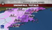
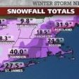
Big one for me in CT was Nemo in 2013. 40” .
-
Lmao. I know the set ups are completely different. It’s just been a while since we’ve had a miller A work out in our favor .
-
This is NOT where you wana be 5/6 days out lol. This will end up a cutter if this trends anything like ANY big storm ever .
-
I believe it. We have pretty darn close to that in Fairfield CT .
-
 All sleet now. Fairfield CT. Eyeballing a foot to foot and a half or so. What do y’all think about the back end thing? Don’t buy into it like usual or solid possibility of a few extra inches on backside? .
 -
Extreme Cold, Snow & Sleet: SECS 1/24 - 1/26
203whiteout replied to TriPol's topic in New York City Metro
Get ready for A LOT of mixing during the height of the storm unfortunately. Even up into CT. We also have all day tomorrow and Saturday for models to continue trending north. Easily 50 miles per run.. . -
“Cory’s in LA! Let’s MECS!” Jan. 24-26 Disco
203whiteout replied to TheSnowman's topic in New England
No shot I see this staying all snow along south coast. Think about it, it has 48 hours plus to trend north lol. The euro is the king with big storms and always will be. Congrats everyone away from the south coast of New England and Boston. Boston looks like a really good place to be for this . -
January 2026 regional war/obs/disco thread
203whiteout replied to Baroclinic Zone's topic in New England
About an inch in Fairfield. Nice burst of snow. Radar returns say it’s coming to an end any moment. I’ll take it. . -
January 2026 regional war/obs/disco thread
203whiteout replied to Baroclinic Zone's topic in New England
Solid snow pack left in SW CT. Even down to the coast. 100% coverage in Fairfield County. Got almost an inch NYE and then another half inch to an inch last night. Looks like it’s gone by mid to late week. SMH. It seems we are stuck in a multi year cycle of storms not coming through this area when the cold is here, but when it’s warm it rains, rains and rains. Epic Greenland blocks that go to waste, negative NAOs go to waste, cold air but very little precip. Very odd weather. Heard the 80s were very similar (I was born 1990). Yes, December was pretty cold and we have a little over a foot of snow this season so far but it’s been years since we’ve had a true nor’easter with totals over a foot plus (several years). Hopefully the mid month time frame works out. I can see a big storm happening followed by another warm up and a lot of rain in this type of set up this January. . -
Agreed. .
-
Yes for some, here in SW CT on the shore it doesn’t feel that way tbh. We got 3 or 4” earlier in month, and that’s it. if you want to call that “Snowy” to each his own. I am not exactly sure where you are located, but I am assuming Jersey or PA? .
-
Lol. Trust me, I would have rather been wrong. Congrats on the pre Xmas snow. Enjoy it. I was hoping everyone would get blessed with a white Xmas forum wide, I just didn’t feel it in my plums. Darn it. .
-
Most likely under a heavier band. Seems folks to the west of city are doing best with better rates and some elevation. We’ve been under very light precip since the start, here. .
-
As expected, absolutely no snow here on CT coast. Light rain. .
-
Lmao, I’m smart enough to not waste my time. Honestly, it wouldn’t make a difference if I did. Just a friendly reminder to not be surprised if this event doesn’t turn out to be much of anything despite some of the snow maps showing a few inches in borderline areas. The storm is happening during the day too which doesn’t help (even in late December) .
-
Last event featured a much colder airmass before the event (it did modify by the time precip moved in). Also, we remained snow during the entire event. Totally different set ups. We had thunderstorms the other day and it was 40 degrees in Fairfield CT today. 36 now. I am not expecting anything more than an inch here on the coast. You’re entitled to your opinion. I genuinely hope you’re right and I’m wrong. I just don’t see it for us on the coastal plain and city.. .
-
I hope expectations are tempered along the coast, and city on south. The airmass is marginal at best. This will be mostly white rain for most, unfortunately. Even if it starts as snow, it will quickly change to rain along the coast and city. If you’re away from the coast, North and West of city this will be a nice 2-4” event. End of the week event looks interesting but will likely feature a very sharp cutoff from SW to NE. I could see NYC getting buried and SW CT get next to nothing in this set up. Hopefully it trends a bit north and includes all snow starved areas. The south has had their fun. I hope it’s our turn.. .
-
December 14th - Snow showers or Plowable snow?
203whiteout replied to Sey-Mour Snow's topic in New England
I’d guess about 3 or 4” here on the coast in Fairfield/Black Rock, CT. Snow is tapering off as I type this. 26 degrees. Winds are starting to blow the snow around. Nice little December event. Hopefully we get at least one “foot plus” event - end of month into January.. . -
You seem confused? lol. This run was not good for Fringe areas. Period. Not expecting more than an inch or two max on CT coast .
-
Yeah, this map doesn’t show the cut off as much as the map I saw on pivotal. I guess it’s just picking up the main precip shield being more consolidated than originally thought which makes sense. South coast of CT has done well in events like these but the north shore of LI is where I would I want to be for a 6” Jack .
-
lol these posts are so biased on “location”. RGEM got much worse for northern fringe areas and south coast of New England. All models seem to be catching onto the idea of a very sharp cutoff to the north. Seems like the southern New England snow drought continues at least into January. Enjoy it down in LI and Jersey .
-
Wasn’t this the storm where every town in Fairfield county got 10” and the Bridgeport spotter was smoking crack and stopped measuring after 6”? Lollll .
-
What radar are you using? About 3”-4” so far and still snowing pretty well in the Black Rock, Bridgeport section of Bridgeport on the water. .


