AACOUNTYMD
-
Posts
94 -
Joined
-
Last visited
Content Type
Profiles
Blogs
Forums
American Weather
Media Demo
Store
Gallery
Everything posted by AACOUNTYMD
-
Outta gas and Outta Time: Early March Winter Storm finale
AACOUNTYMD replied to Ji's topic in Mid Atlantic
very snow-globe-y in Severna Park -
Feb 22nd/23rd "There's no way..." Obs Thread
AACOUNTYMD replied to Maestrobjwa's topic in Mid Atlantic
it has begun. . . ok, sigh of relief! -
Feb 22nd/23rd "There's no way..." Obs Thread
AACOUNTYMD replied to Maestrobjwa's topic in Mid Atlantic
snow to the left of me, blizzard to the right, and here I am, stuck in the middle with 37 and drizzle! -
Feb 22nd/23rd "There's no way..." Obs Thread
AACOUNTYMD replied to Maestrobjwa's topic in Mid Atlantic
Still plain all rain barely any at all actually will Annapolis get Raleighed? Ugh! -
Do you think it is going to get cranking?
-
shovelling the driveway was like shoveling sand
-
Heavy sleet, Crownsville. maybe 6 before switch, 1.5 of sleet since- ish there seems to be a big dry slot heading our way? Is that a thing? Or do you all think it will fill in???
-
Jan 24-26 Weekend Snow and Sleetfest Model Thread Part Tres
AACOUNTYMD replied to H2O's topic in Mid Atlantic
Do models generally take bay water and tributary water temps into account? Bay is colder than usual. For sure. And tributaries are icing over or have iced over. This is a climo thing I know . . . -
Jan 24-26 Weekend Snow and Sleetfest Model Thread Part Tres
AACOUNTYMD replied to H2O's topic in Mid Atlantic
When does the HRRR get all precipitation out of DC/BWI/Baltimore area? -
Quick question from a certified lurker. . . I keep seeing snow maps that have 13+ in and around BWI. . . BUT, many posters are convinced of a long term sleet event. Is this simply because of different models people are hugging? Do models that give 13 inches not believe there will be ANY sleet? So many questions. . .
-
Sorry to interrupt, but, can I be happy about the snow potential again? Someone please tell me it is going to happen! .
-
they are brining the roads around Annapolis and my accuweather forecast says 10 hours of light snow Wednesday night into Thursday morning and accumulating "an inch or two." dunno. . .
-
GO BIRDS!
-
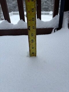
3.5 in Crownsville. maybe we end up with 5.5?
-
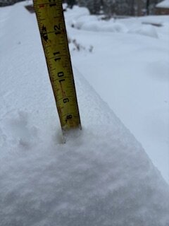
at least two inches in Herald Harbor. Just took a quick trip down to the mall area. All primary and secondary roads have caved (though I didn't see 97)
-
steady, light and I dare say polite snow. . . carefully snowing in Herald Harbor
-
How does it look for us in Central AA county? So much doom and gloom. . .
-
how much later does the NAM start? Later is better, no? with respect to accumulating snow
-
before the Feb 11-12 thread was shut down, there was an undercurrent or perhaps just plain current of "this is going to be a bust." Now I am stressed. That is my only observation, and that it is sunny out.
-
Can anyone give a starting time window on Tuesday. In lurking through the pages, starting time in DC and east after 4:00 on Tuesday? thanks!
-
here too
-
snow remains steady. beautiful.
-
Hasn't stopped snowing all day. . . truly a wonder Any Herald Harbor, Arden, Palisades, Sherwood Forest people out here?

-
constant snizzle. . . but seems to be picking up a bit. Close to 8 here
-
very unscientific. . . but looks like7.5 hasn't really stopped. . . still light snow. keeps looking like the radar is going to shut off the snow, but just keeps coming. I'll take it. In the Herald Harbor part of Crownsville. . . on the Severn