Ruin
-
Posts
1,499 -
Joined
-
Last visited
Content Type
Profiles
Blogs
Forums
American Weather
Media Demo
Store
Gallery
Everything posted by Ruin
-
Central PA Winter 25/26 Discussion and Obs
Ruin replied to MAG5035's topic in Upstate New York/Pennsylvania
yeah I even had them when its windy its total bs -
Central PA Winter 25/26 Discussion and Obs
Ruin replied to MAG5035's topic in Upstate New York/Pennsylvania
yep I lost 3 plus inches in my front yard today -
Central PA Winter 25/26 Discussion and Obs
Ruin replied to MAG5035's topic in Upstate New York/Pennsylvania
notice how every system is a big one then as the event gets closer it just gets weaker 90% of the time -
Central PA Winter 25/26 Discussion and Obs
Ruin replied to MAG5035's topic in Upstate New York/Pennsylvania
little to no accumulation is what they love the best fav phrase lol -
Central PA Winter 25/26 Discussion and Obs
Ruin replied to MAG5035's topic in Upstate New York/Pennsylvania
-
Central PA Winter 25/26 Discussion and Obs
Ruin replied to MAG5035's topic in Upstate New York/Pennsylvania
up to 50 forecast 41? yeah how can it be this inaccurate lol -
Central PA Winter 25/26 Discussion and Obs
Ruin replied to MAG5035's topic in Upstate New York/Pennsylvania
LOL I feel its over for snow this year it was nice to have a nice blanket of white on the ground for this long. -
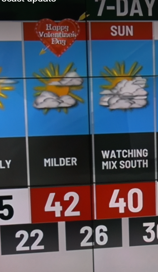
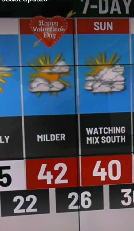
February 2026 Medium/ Long Range Discussion: 150K Salary Needed to Post
Ruin replied to Weather Will's topic in Mid Atlantic
what im saying most of the cold we had was a waste -
February 2026 Medium/ Long Range Discussion: 150K Salary Needed to Post
Ruin replied to Weather Will's topic in Mid Atlantic
2 months of cold 1 real snow storm lol -
Central PA Winter 25/26 Discussion and Obs
Ruin replied to MAG5035's topic in Upstate New York/Pennsylvania
Good, 2 months of really, really cold weather. And we can only mustard one snowstorm.It's pretty sad.I really hope we get something else.Before the cold weather leaves -
February 2026 Medium/ Long Range Discussion: 150K Salary Needed to Post
Ruin replied to Weather Will's topic in Mid Atlantic
remember always hearing where ever it comes into the west coast is normally where it exits in the east. Ill tell you this what wasted cold season we had only getting 1 real storm -
Central PA Winter 25/26 Discussion and Obs
Ruin replied to MAG5035's topic in Upstate New York/Pennsylvania
they hardly ever get it right -
Central PA Winter 25/26 Discussion and Obs
Ruin replied to MAG5035's topic in Upstate New York/Pennsylvania
We had highs in the mid teens.And we had lows at zero or negative for a week -
Central PA Winter 25/26 Discussion and Obs
Ruin replied to MAG5035's topic in Upstate New York/Pennsylvania
how many days has it been now we havent hit the freezing mark. We are very well below normal for this winter in temps so far. I think the long range winter models showed cold early on but warming end of jan into feb that doesnt look accurate at all any more. -
Central PA Winter 25/26 Discussion and Obs
Ruin replied to MAG5035's topic in Upstate New York/Pennsylvania
This has to be one of the longest cold snaps in the last 20 years. while it may not be the coldest we ever had its pretty long lived. I havent seen snow stick around and hardly melt for a week like this last storm in a long time. -
Central PA Winter 25/26 Discussion and Obs
Ruin replied to MAG5035's topic in Upstate New York/Pennsylvania
sadly we often dont get a second snow storm after we just had a big one. so this long lived lie snow breeds snow I never bought. so many times the next storm misses or never forms. I think I only remember 2 times of back to back snow storms. one of them were back to back blizzards after the first one the meteorologist even said the chances of a second blizzard is nothing because it just doesnt happen. I mean we got the second storm but it rarely happens. -
Central PA Winter 25/26 Discussion and Obs
Ruin replied to MAG5035's topic in Upstate New York/Pennsylvania
Yesterday it got to twenty three.When the forecast was twenty today, we were at twenty six when the forecast was at nineteen severe surprise.At temperatures got that high.Considering, we were supposed to only be in the team -
Central PA Winter 25/26 Discussion and Obs
Ruin replied to MAG5035's topic in Upstate New York/Pennsylvania
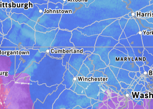
so no chances at all this moves enough north west or the precip shield goes back enough to get any snow in central PA? -
Central PA Winter 25/26 Discussion and Obs
Ruin replied to MAG5035's topic in Upstate New York/Pennsylvania
mother of god -
Central PA Winter 25/26 Discussion and Obs
Ruin replied to MAG5035's topic in Upstate New York/Pennsylvania
about 13 inchs before the sleet started then changed back over we hit just over 13 again then more sleet i ddint measure again after that -
Central PA Winter 25/26 Discussion and Obs
Ruin replied to MAG5035's topic in Upstate New York/Pennsylvania
I am at my dad's he us right at the airport. I have 11 inches almost a foot -
Central PA Winter 25/26 Discussion and Obs
Ruin replied to MAG5035's topic in Upstate New York/Pennsylvania
Very hvy snow no pingers yet -
Central PA Winter 25/26 Discussion and Obs
Ruin replied to MAG5035's topic in Upstate New York/Pennsylvania
nah -
Central PA Winter 25/26 Discussion and Obs
Ruin replied to MAG5035's topic in Upstate New York/Pennsylvania
sleet line is just north of dc atm -
Central PA Winter 25/26 Discussion and Obs
Ruin replied to MAG5035's topic in Upstate New York/Pennsylvania
nah its still hours away