

Sernest14
-
Posts
340 -
Joined
-
Last visited
Content Type
Profiles
Blogs
Forums
American Weather
Media Demo
Store
Gallery
Posts posted by Sernest14
-
-
NAM shows wintry precip starting at 6 compared to HRRR showing at 4.
-
Can we go ahead and lock in the HRRR kuchera ratios?
-
 1
1
-
-
Need that cold air to come in just a hair more quickly and we could have a nice snowfall
-
Ha! Glad it wasn’t just my eyes playing tricks
-
Not sure if it means anything but the NAM has the cooler air down more into Kentucky/TN/SwVA at 18z tomorrow compared to the last 3 runs with the precip field more filled in. Hoping that means the cooling is coming in a little more quick
-
5 minutes ago, Snowmadness said:
12K NAM and RGEM still look good.
Can't get a good gauge on 12k vs 3k - seems like 3k has been underdone with past so may be a good blend between the 2? anyone notice anything different between the 2 with past storms?
-
Huggin the hell out of the RGEM - still gives us 5-8"

-
1
-
-
ooof - 12Z suites all look bad - crazy how much have changes in less than 24 hours across the board
-
Kuchera still looks to give ~5”. I think we’re starting to zero in a bit more on a 4-6” event
-
Have about 2 frames of this:
-
1 minute ago, RVASnowLover said:
You talking about the first wave?
2nd wave- nothing our way on the first- should clarify, very little
-
Looks like a good thump after the initial rain pulls through though
-
NAM 0z seems a bit warmer to start. Decent rain
(had to zoom in, not too heavy)
-
3 minutes ago, Rvarookie said:
Should we be concerned with the trends? It feels like we are bleeding a lil too much now
I think the trends at least keep us out of the ice/mix potential which is good - even less amped gets us 4-5" if the 18z is right - looking forward to the 0z runs though. I don't believe we'll get pushed too much south - that's a lot of suppression still to happen
-
Euro not great for most but still keeps us at the 4-5" range
-
Just now, WinterWxLuvr said:

Seems very conservative given what the models have shown outside of the GFS. Figured that 10% would be fairly widespread with a decent area of 40%
-
14 minutes ago, WinterWxLuvr said:
HPC certainly doesn’t think the second wave will be south. When in doubt go with the pros.

What's Thursday 00z to Friday 00z show for this? or do you have a link - can never seem to find.
-
24 minutes ago, caviman2201 said:
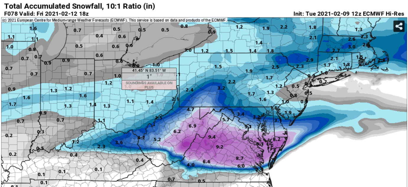
Can someone smarter than me tell me what they're thinking about ratios on this? Seems plenty cold but soundings show very little lift in the DGZ for this event. WxBell showing Kuchera ratios around 8-10:1. Does that seem reasonable?
I thought I was seeing the opposite in regards to Kuchera ratios - looked like they were more 12:1 given that the kuchera maps showed more than the 10:1 maps
-
Just now, RVASnowLover said:
I think some are waiting for the Gfs to hop on board. It’s still showing ice
Yeah went back to look at the model trend loops for GFS and what they have is identical to the GFS - just seems irresponsible, and lazy, to only lean 1 way when everything else says otherwise.
-
Just now, Inudaw said:
History?
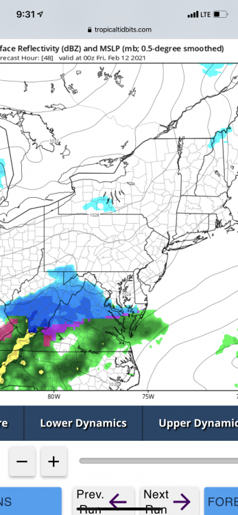
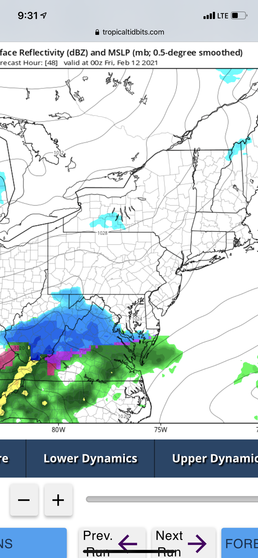
 Add a few degrees aloft and this is what you get.
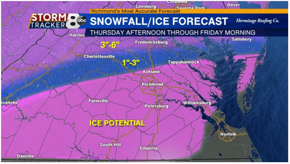
For Richmond and south, yeah but 64 North and West. 1-3" in those areas where models have continuously given them 8+ just seems odd.
-
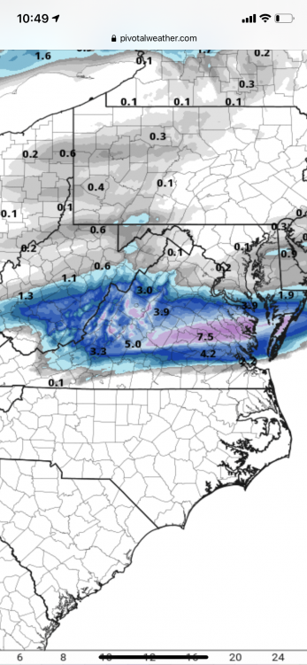
I don't get how they come up with this - especially that 1-3" , 3-6"
 - GFS, Euro, CMC, NAM - nothing is showing this.
-
Just now, RVASnowLover said:
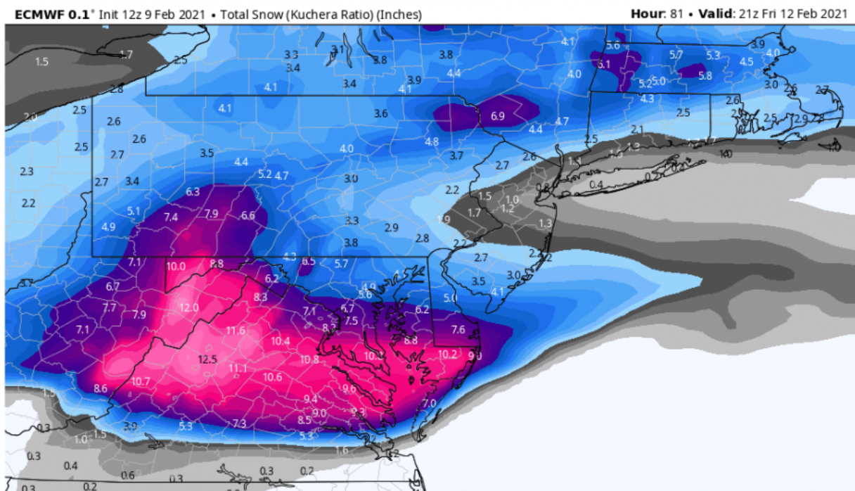
Euro pretty similar to the UK. 8-10 in the metro. Even Petersburg with a nice hit. It continues the trend of slow ticks south each run. No access to a Kuchera map
Stole from other thread

-
1
-
 1
1
-
-
Just now, eaglesin2011 said:
Cool ,another 1 to 5 inch storm on the way for most of this area...
I'm thinking 4-5" on the low side - saw someone else had mentioned ratios could be more 12:1 to 15:1 as well.
-
Another nice Euro hit - expands a little more south again

-
2
-
1
-


Richmond Metro/Hampton Roads Discussion
in Mid Atlantic
Posted
Sleet mixed in with this rain coming through in Ashland. @ 36