

Sernest14
-
Posts
340 -
Joined
-
Last visited
Content Type
Profiles
Blogs
Forums
American Weather
Media Demo
Store
Gallery
Posts posted by Sernest14
-
-
and most of the above for our area is overnight tonight
-
 1
1
-
-
Just now, wasnow215 said:
You mean for Sun/Mon. It’s not bad for overnight tonight and it’s been bad pretty much the whole time for Sun/Mon. Again GFS vs Euro at 96-120 hours? I wouldn’t bet against Euro. I think the GFS is missing something but we will know soon enough huh?
Yeah for Sun/Monday - essentially ends precipitation Sunday evening 7pm with just about all rain.
-
1
-
-
Great run for SWVA - bad for most everyone else compared to all other models/previous runs
-
Ooof - 18Z GFS is baaad
-
18z GFS looks quicker (not by much at all but low is in OK) and more weak through 60 compared to 12z Euro
-
4 minutes ago, RVASnowLover said:
Don’t know if it’s right but the 18z HRRR gives us more snow for tomorrow
Gives 2", the precip field on radar is more amped than any models are showing too - but good ole radar hallucinations - do think we get an inch or 2 out of this system though
-
2
-
-
You also have 1 member that is far NW Ohio with the L that is probably pulling the OP placement west more than it will be (wishful thinking)
-
The ENS low placements are pretty solid. A number of them right where we need with a few outliers both ways. Only a handful are really where the OP shows or more west.
.thumb.png.be17bc40485514037442a442cc343bfc.png)
-
2
-
-
snow depth goes form 6.5" to 2"
-
Through 132 Euro looks good - need to have that low east of OBX and not come up the bay though like it just did. Still 6" before the flip to rain then back to mix/snow later Monday.
-
11 minutes ago, BristowWx said:
not sure what you mean? GFS OG has had the primary doing the Ohio tour for about 5 runs now. not saying it right but certainly not all over the place IMO.
10 minutes ago, Interstate said:But it has... it has been driving the primary low into Ohio for awhile now
It has been through Ohio but more so talking about the coastal low that i feel as been jumping around.
-
8 minutes ago, jaydreb said:
If “disaster” means 3-6” snowfall then we must be in pretty good shape.
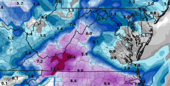
mostly a 2-3" storm for 95 and points ~50 miles west. Half of total QPF is rain/mix
-
well that run was a disaster. good thing it's been all over the place and hasn't really had any consistently.
-
11 minutes ago, eaglesin2011 said:
Gonna really depend where that moisture sets up that's coming in near Memphis TN ... Its holding together so far but will get pulled into the coast system. Will be interesting to see how it plays out...
coastal system radar looks to be expanded more north than models depicted so hoping that is more favorable to get us some flakes
-
Another solid uk and euro run
Won’t let me post maps but ~7” on us and 13.5” euro
-
2
-
-
43 minutes ago, RVASnowLover said:
00z gfs was bad for everyone. Transfer is too slow. Both para and op GFS still wants to give southern Va and NC good hits on Thursday. 1 inch here in Richmond
Trending towards the euro though so that’s good (for Sunday/Monday). See what uk and euro look like for 00z- hopefully they hold
-
2
-
-
Wow Still 12-18 hours left of snow with that and in the comma head for the last bit as well
-
4
-
-
I feel like that is one of those find the differences comparisons- identical through 90
-
1
-
-
Just now, JB Fins said:
Usually NBC12 sounds the alarm with their First Alert Weather Day the first sign of an impactful Euro Run, was surprised Duncan mentioned, and I am paraphrasing, more rain than anything else with the Sunday/Monday threat.
Cold should be in place- very little rain IMO the way things look and have been trending unless you’re Hampton roads/va beach
-
 1
1
-
-
.1” haha- get the roads treated
-
NAM is completely dry for Thursday for all of VA. GFS comes back a little north but looks to be very light and brief - better than 12z though
-
radar so far so good - not sure if anything is actually making it to the surface but should be a good sign to at least see some flakes *fingers crossed*
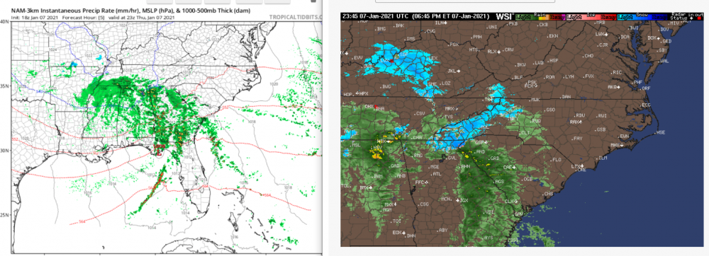
Comparing to the HRRR - looks like that has had a good feel for this which did bring some light stuff into the area.
-
the low in Maine on the 18z 12k NAM is weaker and precipitation stays a little more together which allows for an inch or 2 in and around richmond. 18Z 3K has the stronger low more quickly and stops anything from getting close to us.
-
Need this storm to move just a hair quicker and beat the low coming down into Maine

Richmond Metro/Hampton Roads Discussion
in Mid Atlantic
Posted
Para actually looks better this run and has been one to be going back on forth a bit (at least for us):