

HeadInTheClouds
-
Posts
1,598 -
Joined
-
Last visited
Content Type
Profiles
Blogs
Forums
American Weather
Media Demo
Store
Gallery
Posts posted by HeadInTheClouds
-
-
15 minutes ago, Winterweatherlover said:
This is a really big storm and very good model consensus of a significant snowfall North of I84.
I don't know about model consensus right now. FWIW the Ukie, CMC, RGEM, and 18z Nam are all showing less than 6 inches when using less than 10:1 ratio.
-
 1
1
-
-
8 minutes ago, sussexcountyobs said:
Winter storm watch is already posted for Sullivan and Deleware county in NY
I just got a WSW issued here in Dutchess which is surprising because NWS Albany isn't an office that issues advisories/watches well in advance like other offices.
-
These models have no clue still. 18z nam gives me 15 inches less than 12z, lol.
-
1
-
-
1 minute ago, Winterweatherlover said:
It’s not perfect but the RGEM usually isn’t way off and if anytung is usually too warm so it’s a good model to rule in snow chances if it shows somehung good.
That model hasn't been that great either. It's usually too warm and too light on precip.
-
1 minute ago, Winterweatherlover said:
Don’t care too much about it’s thermals but the east track is a problem, without heavy banding NYC has no chance.
I was speaking in general terms, not just this storm. I don't trust that model. Actually I don't trust any 1 model.
-
1
-
-
1 minute ago, wilsonvoid1 said:
What happen to this model? it showed 12-15 inches for NyC just two days ago. Terrible model. I guess the trend is no snow
.Some people think it's a good model but all I see is flip flopping run to run and questionable thermals.
-
1
-
-
33 with some light snow. Picked up 2 inches for a total of 17.5 this season.
-
34 with moderate snow, sticking to colder surfaces.
-
1
-
-
38 and rain right now IMBY.
-
1
-
-
Still hate 10:1 maps in this setup. Do Pivotal 10:1 maps count sleet as snow?
-
Can't be using 10:1 ratio maps in a marginal thermal event.
.thumb.png.c59215123e7cb299d06394cd68ededd3.png)
.thumb.png.faf170d0059472fbf93ab429cfceadc4.png)
-
29 minutes ago, Winterweatherlover said:
Seems more qpf than other models. If that much qpf truly falls the same places that did well on 2/28 could do well again.
18z Vs 12z is considerably more in northern areas. .5 vs .3 by me.
-
2
-
-
10 minutes ago, snowman19 said:
Not even worth arguing about an operational run this far away. It is not going to play out anything like that in reality. Also of note the Euro is the only model showing thisThe CMC also shows a deepening coastal.
-
2
-
 1
1
-
-
21 minutes ago, cleetussnow said:
14th is under and not very interesting on the 12z GFS VERBATIM. That one is still all over the place on the models, so nothing to be taken verbatim. 6 days out.
But this is kind of close in terms of capture:
Both CMC and Euro are similar in terms of 2nd wave which is a coastal. GFS on it's own right now.
-
Wave 1 looks like a 1-2 inch type event for most and that's only because most precip falls at night. Wave 2 still a ways out but CMC looks similar to 00z Euro. Dicey at coast but interior would do well. GFS not impressed but will probably correct.
-
Disappointing model runs tonight with respect to 2nd wave.
-
1
-
-
17 minutes ago, jayyy said:

Storms 1&2 per 12z euro
Love seeing pink and purples over my house here in northern MD. I am under 2” for the entire season.
.That's not including all of the second wave. You have to go out further for northern areas. It still likely won't be accurate at 10:1.
-
1
-
-
3 minutes ago, snowman19 said:
In reality on Saturday, that’s probably all white rain and non accumulating slop. Temps are in the mid to upper 30’s, during the day, approaching mid-March. Those 10:1 maps are going to be way overdoneThat is incorrect, especially north of the city. If that particular scenario were to verify most of the precip would fall at night when temps were close to 30(especially around 84) so it would accumulate.
-
16 minutes ago, Winterweatherlover said:
I’m so confused by this pattern I guess the models are too.
The models are struggling right now. Every model run is a different adventure. I don't think we start to see better consistency until mid week.
-
Just now, MJO812 said:
Ranked better than the gfs
That's a low bar.
-
 3
3
-
-
21 minutes ago, Winterweatherlover said:
Weak and flat is what you want to see at hour 168, not amped. However the Ukie is a terrible model lately.
It's a terrible model all the time.
-
 1
1
-
 1
1
-
-
33 with a light mix. Picked up 1.5 inches of snow/sleet cement mix overnight.
-
3
-
-
33 and a major sleetfest
-
1
-
-
Down to 33, moderate snow, sticking on colder surfaces.
.png.28834e454dad7ce0b58bb70a1a59feb6.png)
.png.d70387a433b816afce1a5a346fd567e8.png)
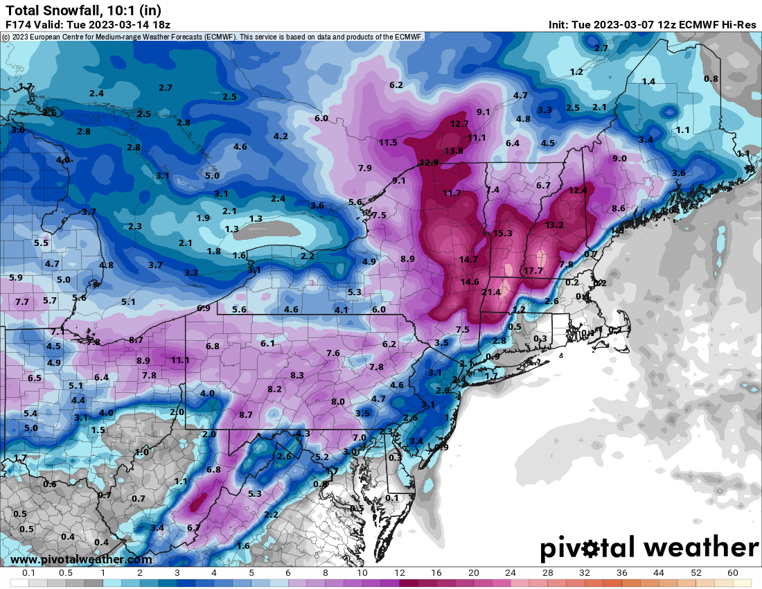
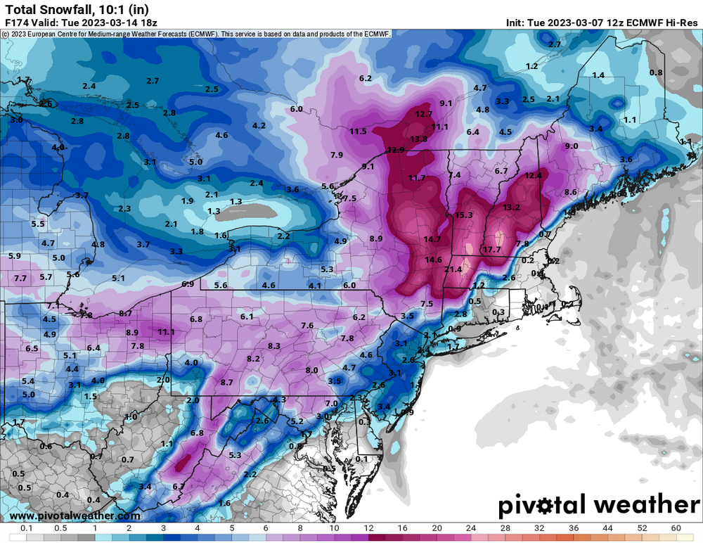
March 13-14th Nor'easter Threat
in New York City Metro
Posted
Not up here. NWS Albany saying they expect 8-10:1 for much of storm.