

HeadInTheClouds
-
Posts
1,598 -
Joined
-
Last visited
Content Type
Profiles
Blogs
Forums
American Weather
Media Demo
Store
Gallery
Posts posted by HeadInTheClouds
-
-
Winter storm warning just issued for Dutchess county. 5 to 9 Saturday night and 3 to 5 on Sunday. I'm thinking the lower end around 8 in Poughkeepsie area.
-
 1
1
-
-
1 minute ago, NJwx85 said:
If you look at 3k NAM at 01z sim radar you’ll see a big dry slot over our area with thunderstorms along the NJ coast near the SLP. Those storms will have the potential of robbing us of dynamics and moisture due to subsidence. This is just one model so it’s not necessarily correct.
I don't trust the 3k or hrrr unless it's within 24 hours, maybe even 12.
-
3 minutes ago, Brasiluvsnow said:
definitely less QPF as it got closer to our area from down South as the model is not spitting out 1 or 1.25 as the other models ( think the nam showed this ) is that because the system is not maintaining strength ?
It's basically showing what most other models are showing in the area which is .8-1.0 total QPF. The Euro was the driest with .6-.8. It seems this system is lacking dynamics once the initial precip comes through and then some areas get dry slotted.
-
1
-
-
1 minute ago, wilsonvoid1 said:
this model used to be good, now it's always too warm. you got almost a perfect benchmark miller A nor'easter, on beginning of January, it's going to be snow in my opinion. models always underestimate wet bulbing and dynamic cooling whe the low starts cranking! i think we get an overachiever
.Most models have BL temps in mid 30's in NYC metro and Long Island. It's going to be difficult to get significant accums in those areas. Those 10:1 maps are bogus.
-
2 minutes ago, HVSnowLover said:
If last winter is any indication this is over for anyone SE of 95 and is not looking good for anyone SE of I287. The rgem/cmc combo was deadly last year but this a new season so we’ll see.
They aren't perfect and tend to be on the warm side but I would take that combo over the Nam/GFS every time.
-
2
-
-
19 minutes ago, hudsonvalley21 said:
Definitely has my attention especially up this way. The flooding/power loss potential I hope doesn’t come to fruition. After the first system comes thru will see what the models show for the 2nd one. Who knows, we could get a good front end thump of snow with #2. That could help with some rain absorption with this weekends snow.
I think a frond end thump is a pretty good bet especially along and north of 84. That high and blocking means business and the CAD is pretty strong. The CMC and GFS are recognizing this more than the Euro right now.
-
2
-
-
56 minutes ago, vegan_edible said:
we're also dealing with a single model that at one time was considered great but recently cant seem to get it together...
It's been so meh after the "upgrade". It used to be the king not it's more like Euro trash IMO.
-
Not to spoil the fun but it's babka.
Quote-
 1
1
-
-
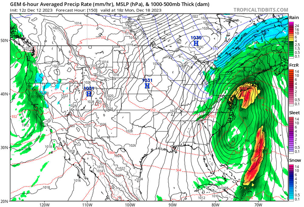
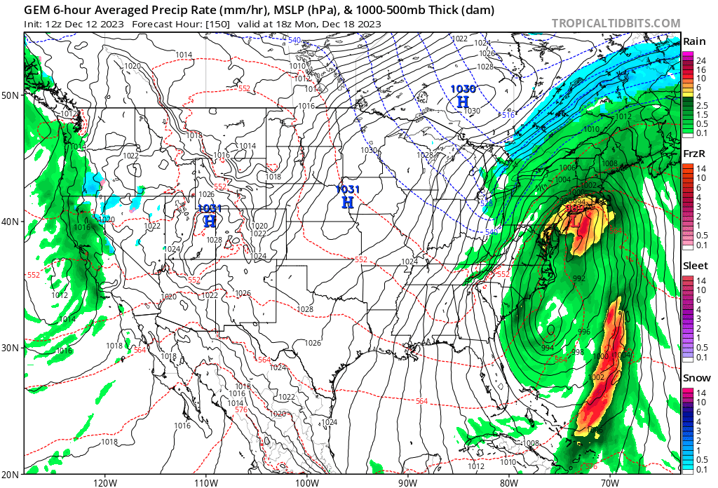
Regardless of the exact track I'm honestly surprised by the meh QPF on the 12z Euro. I would think it would be more than .75 or so given the source region and tapping some atlantic moisture. Pretty weak if you ask me.
-
43 minutes ago, snowman19 said:
Yep. Absolutely no cold air anywhere close, all southern stream driven, rain all the way to MontrealThanks for that info because we couldn't possibly see that.
-
1
-
 1
1
-
2
-
 1
1
-
-
2 hours ago, JustinRP37 said:
Listen, I am about as negative as they come, but this place is really ridiculous now. This weekend will TORCH, but month to date, I am 1.7 degrees above normal in my area. Again you can all talk about the city etc, but New England and north NY has not been as bad as you all make it sound. And the anomaly over the Hudson Bay is quite warm, but if you notice that is largely over the water itself thanks to the summer. Decembers, once again, are RARELY snowy in these part until the last week. It can snow in an above normal temperature pattern and it does. It has also been snowing mood snow all day here with a light accumulation. Next week looks average for the time of year before another warmup on the weekend.
Yup, you would think it's been tropical from the talk. It's been an average December up here in MHV. Yesterday's high was 37 with snow showers. Last night went down to 22 and today's high was 35. After a mild weekend most of next week will be close to 40 for daytime highs. Not planting any palm trees here.
-
36 and mostly snow here in Dutchess, coating on cars and grass.
-
2 minutes ago, the_other_guy said:
I mean, it is all relative. Didnt some of these models have a widespread 10 inch plus? you can basically wipe your behind with that number.
If 10 inches meant “you will get a lot” then they did a great job. But in actual numbers the numbers we were looking at were ridiculously inflated. Thank god for that btw
There are plenty of spots that have reported 7-8 inches so far and it's not over yet.
-
55 with some light rain still. 3.10 in the bucket.
-
23 minutes ago, qg_omega said:
Sure, very similar for round one, which is a massive bust and the main debate for the past few days. The heavy band well ahead of the storm did not happen. Not sure why no one can acknowledge this, those who tossed the heavy rain from round one (today) from the city NE were correct.

And most models have shown for 2 days now that the most significant impacts will be from the remnant low on Sunday and Sunday night except for the GFS (until 12z) which you continued to hug.
-
4 hours ago, qg_omega said:

Are you going to post the 12z GFS?
-
8
-
-
Perfect late afternoon/evening in HV.
-
1 hour ago, wishcast_hater said:

I received 7” of rain. Just incredible. That’s on top of last weekends incredible rains.
.That's a lot of rain especially with what has fallen in the past month. Dutchess county east of the taconic had some big amounts. Had 3.15 here in Hyde Park.
-
2 minutes ago, IrishRob17 said:
It IS a disaster there right now. Many reports of people trapped.
I know, probably going to get worse unfortunately.
-
I still can't believe how hard and for how long it has been raining in the Bear Mountain area around 9W. It's going to be a disaster in that area.
-
12 minutes ago, Winterweatherlover said:
This winter was about as climo as you can get. Bad for most south of I90 but horrifically bad I95 and SE.
The I84 corridor def cashed in big time in March and looks like got close to average.
You have to go up to I90 to be near average. I'm 20 miles north of 84 and have 26.5 this year which is still well below average.
-
Hit 54 today, snow melting quickly.
-
4 minutes ago, Winterweatherlover said:
The RGEM never had like more than an inch for NYC but I’ll admit it busted way too low further north.
Every model basically sucked with this storm and the RGEM/CMC were no exception. Besides being bad for areas well north and west, some parts of Long Island had snow which I don't think they had correct either. They are consistently too warm and dry.
-
1
-
-
2 minutes ago, MJO812 said:
I went through all the Euro runs and Nam runs that had accumulating snow for the NYC area.
What a shame
Every model was really bad this storm.
-
5
-


Two Mdt to high impact events NYC subforum; wknd Jan 6-7 Incl OBS, and mid week Jan 9-10 (incl OBS). Total water equiv by 00z/11 general 2", possibly 6" includes snow-ice mainly interior. RVR flood potential increases Jan 10 and beyond. Damaging wind.
in New York City Metro
Posted
Me too. I think min is 6 and absolute max is 10.