

StormChazer
-
Posts
1,231 -
Joined
-
Last visited
Content Type
Profiles
Blogs
Forums
American Weather
Media Demo
Store
Gallery
Everything posted by StormChazer
-

MO/KS/AR/OK 2022-2023 Winter Discussion
StormChazer replied to JoMo's topic in Central/Western States
Still just rain here in Tulsa. Hoping this band from the south moving northward will be the push that brings the transition on. -
MO/KS/AR/OK 2022-2023 Winter Discussion
StormChazer replied to JoMo's topic in Central/Western States
Both metros in OK now under the Winter Storm Warning. Soon we can start tracking the rain/snow line to see how models have been handling it. -
MO/KS/AR/OK 2022-2023 Winter Discussion
StormChazer replied to JoMo's topic in Central/Western States
Am I allowed to ignore it because I don't like it? -
MO/KS/AR/OK 2022-2023 Winter Discussion
StormChazer replied to JoMo's topic in Central/Western States
TSA went all out for NE Arkansas, still going conservative on Tulsa area.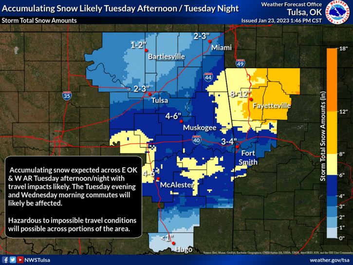
-
MO/KS/AR/OK 2022-2023 Winter Discussion
StormChazer replied to JoMo's topic in Central/Western States
Euro had a massive northern shift with some totals. 06Z Run Latest 12Z Run. -
MO/KS/AR/OK 2022-2023 Winter Discussion
StormChazer replied to JoMo's topic in Central/Western States
Slight northern jog on GFS, NAM and Icon, might be enough to push Tulsa county into a Winter Storm Watch. Canadian and the long range 12Z HRRR keeping that heaviest snow to the south. Euro still playing catch up with the others so I'm not considering it as heavily as the others right now(has been an outlier almost this entire time so far). -
MO/KS/AR/OK 2022-2023 Winter Discussion
StormChazer replied to JoMo's topic in Central/Western States
Tulsa finally jumping on board with the higher amounts in most places.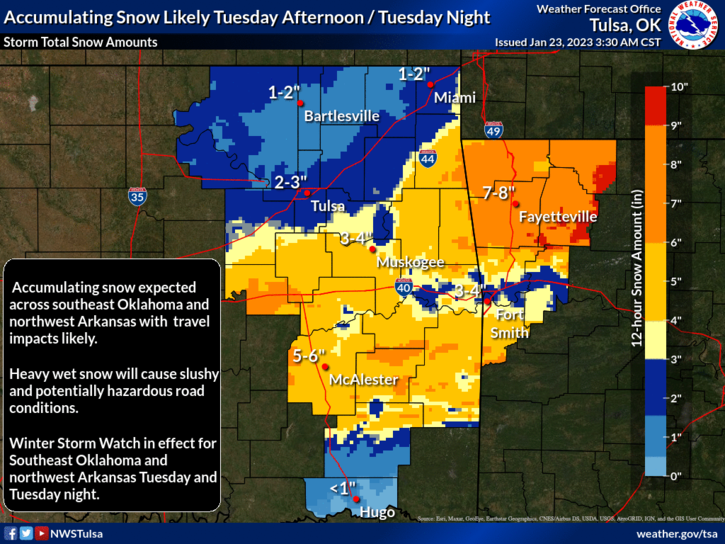
-
MO/KS/AR/OK 2022-2023 Winter Discussion
StormChazer replied to JoMo's topic in Central/Western States
This is probably my inexperience showing through, as obviously the NWS meteorologists and even news meteorologists know more than me. But it seems like most of them are calling for just 1-2 inches of snow. I know there will be initial melting from ground temps, onset rain that will cut down potential totals and the fact that it’ll be above 32, so additional melting. But 1-2(or in NWS Tulsa’s case less than an inch of snow) just seems too low to me. I’m not saying that 6 inches should be plastered everywhere but widespread 3-4 doesn’t seem crazy to me. But again, I’m both an amateur and a biased snow lover, so I don’t have the best take on these. -
MO/KS/AR/OK 2022-2023 Winter Discussion
StormChazer replied to JoMo's topic in Central/Western States
I’m ok with the NAM so far, but can’t focus too much that far out on it, it’ll change a lot until about hour 60. it’s all about the storm track and temps(duh). As the models project a further south track, you wind up with less snow totals across the board except for the small core of the low where someone gets hammered. The further north we go, the cooler the air and better chances of prolonged and widespread snow. Any delay of the system at this point also increases higher snow odds as it seems pretty likely that after 6PM Tuesday, temps get low enough and the 540 line pushes east. I still genuinely think someone is going to push getting a foot of snow where that deformation band sets up as the low passes through, but will that be Davis, OK? Out in the higher terrain of the Ozarks? Wichita Falls? Even a 20 mile track difference considerably changes the forecast due to the type of set up. I currently am thinking 4 inches for Tulsa, and that will still make me very happy. -
MO/KS/AR/OK 2022-2023 Winter Discussion
StormChazer replied to JoMo's topic in Central/Western States
With temperature being one of the main concerns, the 12Z NAM has it plenty cold in the areas where it’s snowing. Didn’t love the southern shift of the track overnight, makes me miss out on a lot here in north Tulsa county. But the morning gfs run nudged back North a touch, so hoping for just a couple more nudges and the euro to go back as well.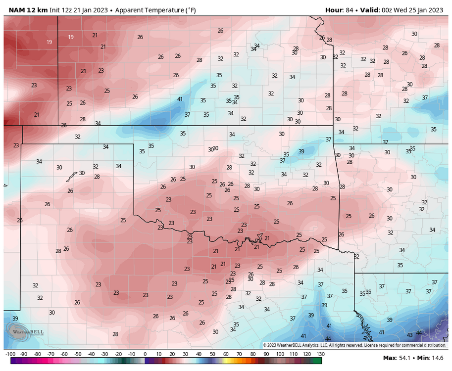
-
MO/KS/AR/OK 2022-2023 Winter Discussion
StormChazer replied to JoMo's topic in Central/Western States
18Z GFS sticking to it's 12Z run. -
MO/KS/AR/OK 2022-2023 Winter Discussion
StormChazer replied to JoMo's topic in Central/Western States
Probability of snow exceeding 6 inches. -
MO/KS/AR/OK 2022-2023 Winter Discussion
StormChazer replied to JoMo's topic in Central/Western States
Here is the Euro Ensemble mean. That's some great agreement right there amongst the 50 runs. Here's all 50 members. -
MO/KS/AR/OK 2022-2023 Winter Discussion
StormChazer replied to JoMo's topic in Central/Western States
4 days out with tight model agreement yielding high snow totals is about best case scenario at this stage of the game. If these stay in agreement for the next 24-36 hours, then at that point I think we can safely say we have a big one on our hands. But I think at this point it's not a stretch to assume that we WILL get snow, just how much? -
MO/KS/AR/OK 2022-2023 Winter Discussion
StormChazer replied to JoMo's topic in Central/Western States
Euro. -
MO/KS/AR/OK 2022-2023 Winter Discussion
StormChazer replied to JoMo's topic in Central/Western States
Here's the GFS to drool over. The lift this run generates is off the charts. -
MO/KS/AR/OK 2022-2023 Winter Discussion
StormChazer replied to JoMo's topic in Central/Western States
This GFS run is going to have some HIGH totals in it. -
MO/KS/AR/OK 2022-2023 Winter Discussion
StormChazer replied to JoMo's topic in Central/Western States
The 06Z Euro run doesn't go out past 90 hours, so can't tell anything yet on the operational. However, the control run of the 06Z Euro goes out 144 hours. FWIW, the control run of the 06Z euro puts down more snow and has the storm track slightly further north than the control run of the 00Z Euro. So we will see if that trend is reflected in the 12Z operational run today. Might be a sign of the models consolidating even more. Here is what I'm talking about. 00Z Euro Control 06Z Euro Control -
MO/KS/AR/OK 2022-2023 Winter Discussion
StormChazer replied to JoMo's topic in Central/Western States
All three major players are now in agreement of this storm dropping significant snowfall in our area for this storm 4 days out, can’t get much better if you’re a snow lover at the moment. still have to refine the track of the low, which inevitably means someone will go from excited to disappointed, but will that be someone to the south, north or east or west? Either way. Feeling good about this at the moment. -
MO/KS/AR/OK 2022-2023 Winter Discussion
StormChazer replied to JoMo's topic in Central/Western States
BIG fan of that Euro run. -
MO/KS/AR/OK 2022-2023 Winter Discussion
StormChazer replied to JoMo's topic in Central/Western States
Maybe another quick burst of snow Sunday morning? Hoping something comes of the 25th. -
MO/KS/AR/OK 2022-2023 Winter Discussion
StormChazer replied to JoMo's topic in Central/Western States
Anyone been able to find an official or preliminary snowfall amount list? -
MO/KS/AR/OK 2022-2023 Winter Discussion
StormChazer replied to JoMo's topic in Central/Western States
Looking forward to seeing the totals to see how accurate the kuchera Vs 10:1 ratio faired. I’d say here in north Owasso, we probably got 2-3 inches, but it’s hard to tell since it’s wind blown. Overall, I’m happy. I think up here we will get a “white Christmas”. -
MO/KS/AR/OK 2022-2023 Winter Discussion
StormChazer replied to JoMo's topic in Central/Western States
More snow squall warnings going out just to the north of Tulsa. Have to watch the back end of this system to see if it swings into Tulsa. -
MO/KS/AR/OK 2022-2023 Winter Discussion
StormChazer replied to JoMo's topic in Central/Western States
Don’t see snow squall warnings this close to home often….so far the roads have iced up here in Tulsa and there’s very light blowing snow, waiting for the main even to see how much we get.

