

KoalaBeer
-
Posts
606 -
Joined
-
Last visited
Content Type
Profiles
Blogs
Forums
American Weather
Media Demo
Store
Gallery
Posts posted by KoalaBeer
-
-
Just now, HIPPYVALLEY said:
My brother has a coating in Exeter.
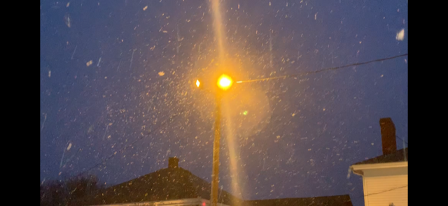
Ya it’s actually borderline moderate snow in Hampton NH. Sitting at the bar having a beer waiting for my to go order and it’s starting to stick to the cars. 34f here, pretty impressive for April 1 with the marine influence I get.
-
 1
1
-
-
Crappy lighting for a photo, but you get the idea. Fatties falling from the sky.
-
1
-
-
2 hours ago, dendrite said:
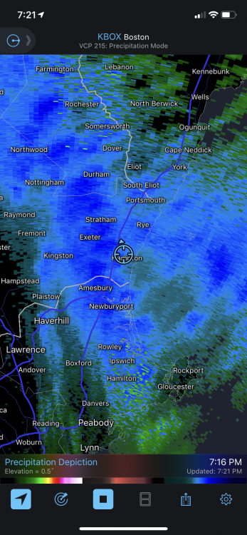
Thank you. Snowing lightly on the coast for about 30 min now but looks like a good squall going to pick things up soon.
-
Anyone got more info on this? Just curious and it’s behind a pay wall.
-
Live news stream shared from the southeast forum.
-
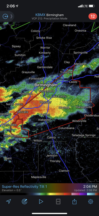
Damn...anyone watching the cell southwest of Atlanta? NWS Peachtree might be taking shelter shortly.
1206 AM EDT Fri Mar 26 2021

...TORNADO EMERGENCY FOR The City of Newnan...

...A TORNADO WARNING REMAINS IN EFFECT UNTIL 1215 AM EDT FOR CENTRAL
COWETA COUNTY...

At 1206 AM EDT, a confirmed large and destructive tornado was located
over Newnan, moving northeast at 55 mph.

TORNADO EMERGENCY for Newnan. This is a PARTICULARLY DANGEROUS
SITUATION. TAKE COVER NOW!
-
20 minutes ago, Moderately Unstable said:
So, it's difficult to tell, but what you can see on the radar is the *orientation* of the couplet changes. In a handoff, you see two distinct mesos, one weakens, the other strengthens. Here, we have the same meso which was "oriented" "up down" and after passing the radar is now "left right". That's the same circulation. The doppler effect only shows motion towards and away from the radar. Ergo, as you translate around a radar site, the orientation of the couplet can shift as the storm motion is captured in the non-storm-relative base reflectivity with a different relative motion (given a different angle of incidence to the site). Same tornado folks. In fairness, there was one single scan that looked "confusing", so if you just looked then you could go "hm what's going on", but subsequent scans, and playing them back with the prior ones, tell us the whole story.
Great post. Obviously the survey will tell the whole story, but this a great analysis of the radar representation.
-
5 minutes ago, rimetree said:
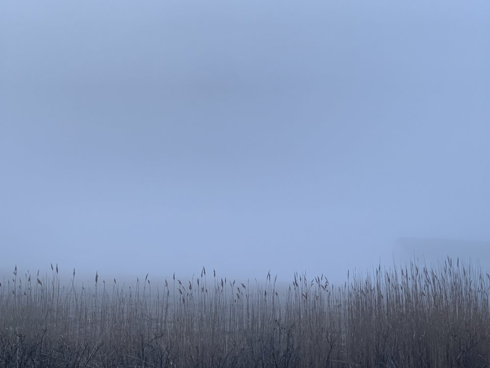
Hit 59 today. Sea fog rolling in now. Don't think we hit 70 here for a while.
Went from drinking a nice IPA on the porch while playing some acoustic guitar in the sun to that fog rolling through in a matter of minutes. Not great...but I’ll take it over being in the southeast right now!
-
1
-
-
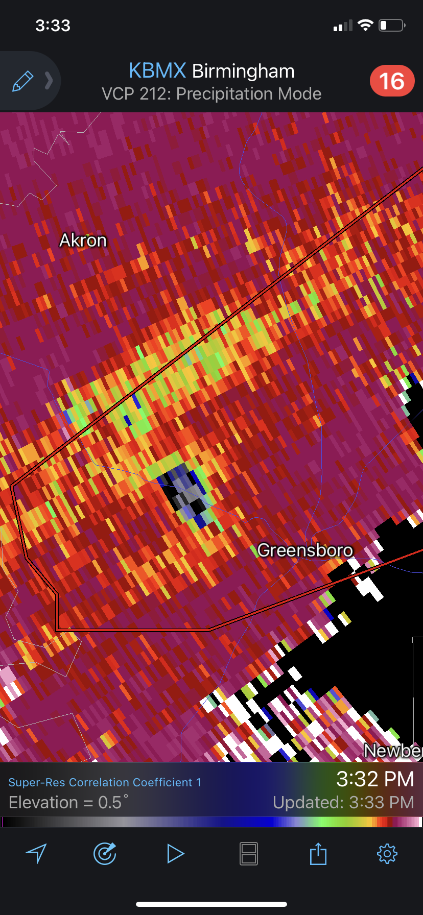
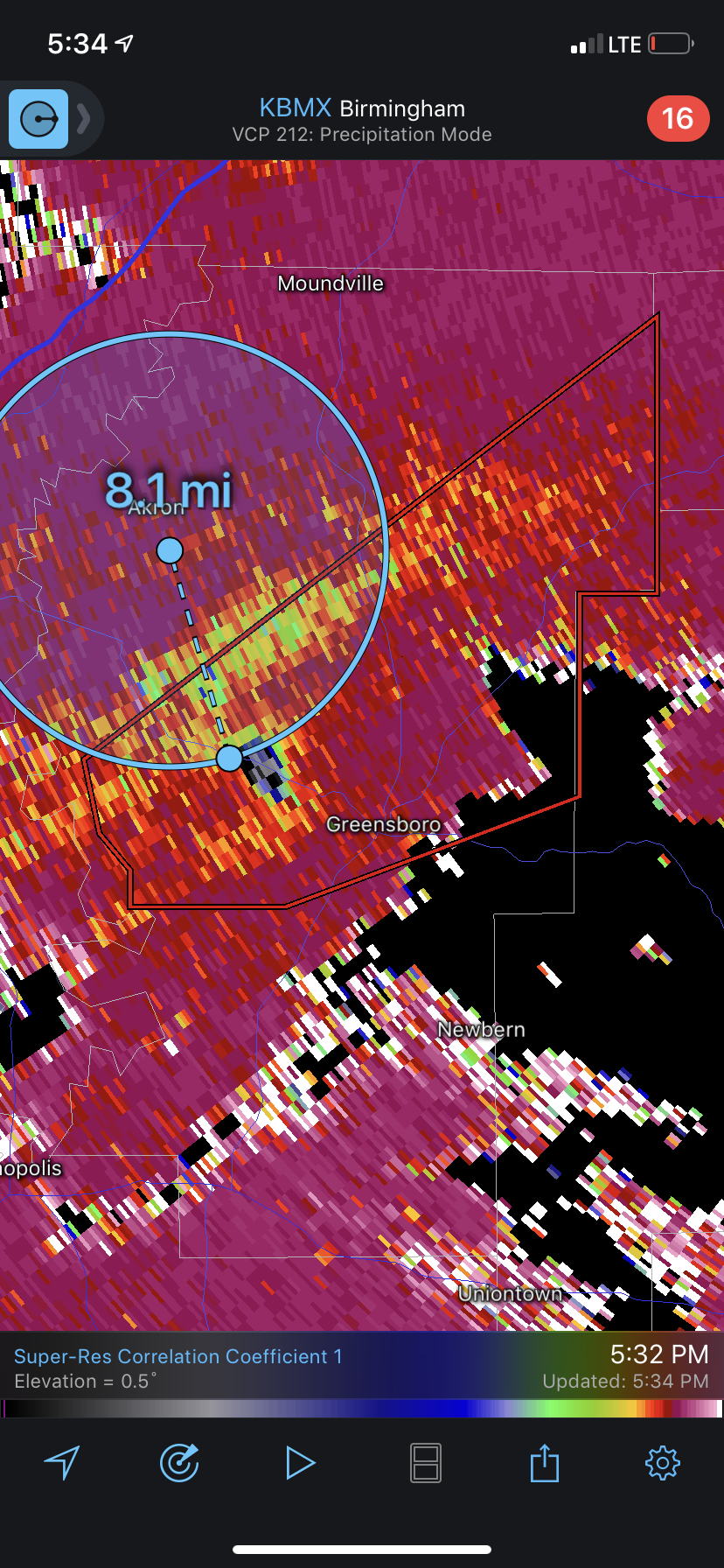
Just now, vman722 said:
Incredible debris ball. So scary
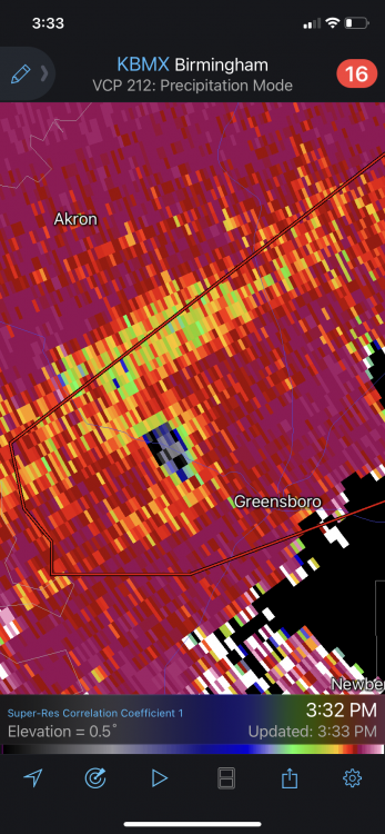
Just doing a real quick guesstimate that’s like what 6-8 mile southeast of the tornado that passed through earlier?
-
4 minutes ago, TexMexWx said:
Couplet SW of Cave Spring, GA is becoming quite intense. The supercell structure looks like slop but it's probably being scanned from pretty high
Ya agreed, looks like junk on normal reflectivities but velocity scans are still damn impressive. That’s a rough spot for a radar hole. Wouldn’t be surprised at all if that’s still producing a significant TOR considering its history....back to mostly lurking for me. Stay safe down there today and keep the great posts and info coming.
-
1
-
-
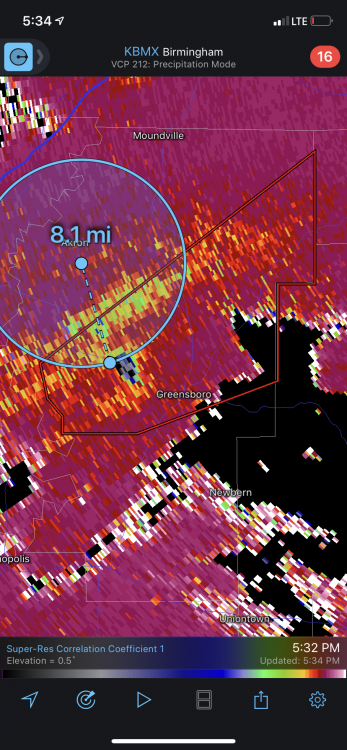
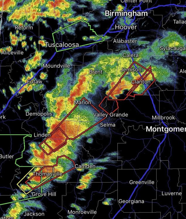
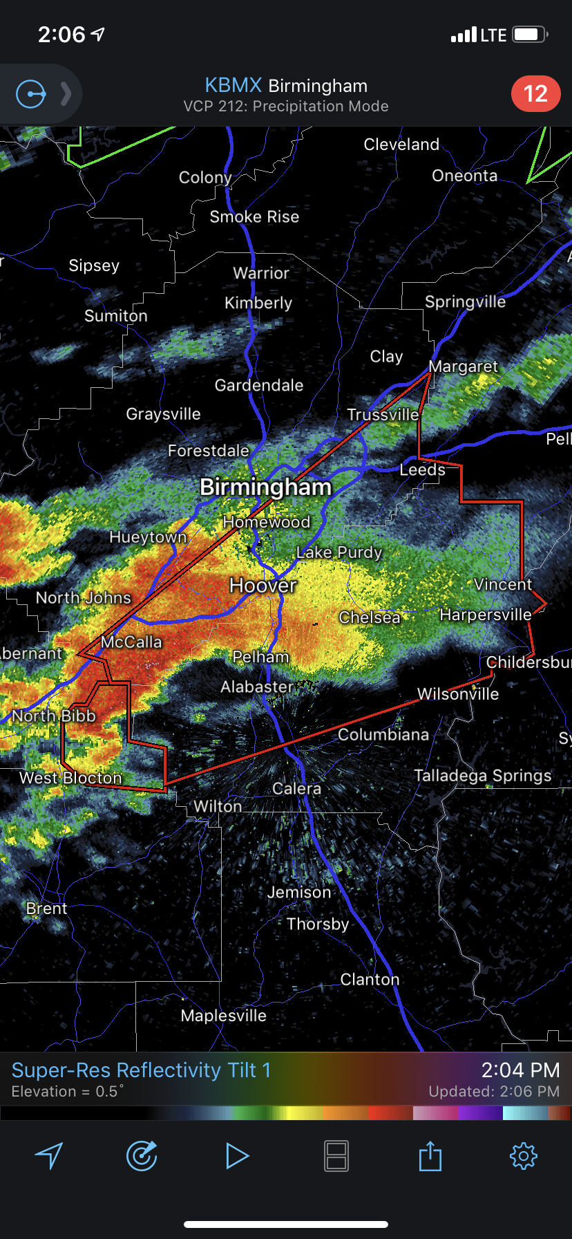
Quite a bit cooler in Hampton today then I was expecting. Still plenty nice enough to fire up the grill later though for the third day in a row! Also wishing for a good outcome for our friends in the south. Birmingham metro is under the gun in a bad way. ~65dbz debris ball on this sucker as well

-
1
-
-
17 minutes ago, CryHavoc said:
Most people do not even know what the SPC is. And most of those that do are not poring over charts to discern the differences between ENH/MDT/HIGH. We're in the niche of niches here.
So yeah, while to the average layperson a "Moderate" risk might not sound threatening, I doubt many of them are looking at advanced modeling to determine exactly what that means. They turn on the weather, see the Mets on TV with their coats off and their serious face on, uttering words like "Potentially historic" or "a long day ahead for much of the viewing area, keep your weather radios on" and assume that things could get really nasty.Jojo is not the type to be overly bullish without reason IMO. I think they're just pointing out that the ceiling here, if the SPC sees things resolving at the right time and place, is a Day 2 high. Heck, we might not even have a Day 2 MDT tomorrow (although I think that's much more likely).
Great points havoc and great conversation, it’s why I love this forum. I would say most people would recognize the SPC maps even if they don’t know the agency by name, maybe that’s a different problem in itself. We are definitely in the niche here and sometimes that’s hard to remember. TV Mets like Spann do a phenomal job putting it into layman’s terms. Having said that I’d still love to see a change up of how the SPC issues it’s enh/mod/high outlooks. About to join a long conference call for work so I’ll have to take off for a while but I hope to hear more suggestions.
-
8 minutes ago, CryHavoc said:
MDT risks are quite rare, esp for D2, and mean anything but average.
I’m well aware of that, but does that convey the right message to anyone but weather nerds or meteorologists? Does the general public really look at a D2 MOD outlook and say “Shit this could be a really bad time tomorrow?” Talking with my friends and family that’s a huge no. But I’m born and raised in the northeast, perhaps I underestimate the weather folks are prepared for in the Deep South.
Edit: I feel like these people are also relying on local media instead of the SPC as well, which honestly might be a good thing.
-
2
-
-
7 minutes ago, DanLarsen34 said:
They’ve only issued a high risk in a day 2 outlook twice: 4-14-12, and 4-7-06.
Given some of the discussion that I’ve seen from emergency management planners over social media today that surrounds the planning surrounding events like this, it might make sense for them to consider doing so this time, especially since the models are converging on a high impact, potentially life threatening scenario across the Deep South.
At a minimum, I would expect to see a moderate risk with a strongly worded discussion mentioning the potential for long-track, violent tornadoes if the model runs continue to show a similar set-up to what they’ve been suggesting so far.
My only gripe with this (no matter if you fall on the more conservative or aggressive side of this forecast) is the absolutely absurd scale in place. What percentage of the population is looking at the discussion compared to just looking at the overall rating? The SPC shouldn’t have to issue a high risk to convey the risk at D2 but I think maybe they should because saying “moderate” doesn’t concern the ceiling of this outbreak at all. Why write in “violent long track tornadoes are possible” if we are just going to say mehhh, this is moderate aka literally meaning average.....
-
34 minutes ago, nwohweather said:
Agreed but it costs $10 Million for a new one, and $500K a year to maintain. Very expensive technology for sure
Ya definitely not cheap, and not trying to drag politics into this to much but obviously it is intertwined. The cost is minuscule even if it only saves a few lives. I’ve read it cost somewhere like 1.5 million - 2 million a year just to keep one active duty service member in Afghanistan. We could spend our money in better places, but I don’t want to beat the bush here and ruffle to many feathers in this thread...it’s prob best saved for a discussion at a different time.
-
 1
1
-
-
43 minutes ago, kayman said:
Blame that on Congress... Charlotte has been lobbying for a closer NWS radar station for nearly 2 decades now... It's the largest urbanized region (3M+ residents) in the nation without a NWS radar site within 70 miles of its location.
That’s absurd, I did not know that...with the insane amount of money we spend on other things that’s just crappy our politicians can’t agree on something seemingly smart and simple. And obviously the NWS is a government agency, but does congress really have that tight of control on the budget? I figured they approve a certain dollar amount and then it’s up to the NOAA/NWS how to allocate or am I grossly mistaken?
-
2
-
-
Current trends don’t support long track violent tornados overnight in my opinion. Sure as hell hope I’m right. Nocturnal violent tornados are straight up nightmare stuff in the southeast. Either way hope all the folks down there stay vigilant and stay tuned into the warnings through the night. Worse atmospheres have produced way more serious TORS then what we have seen so far.
-
1
-
-
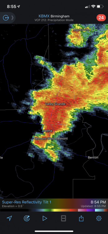
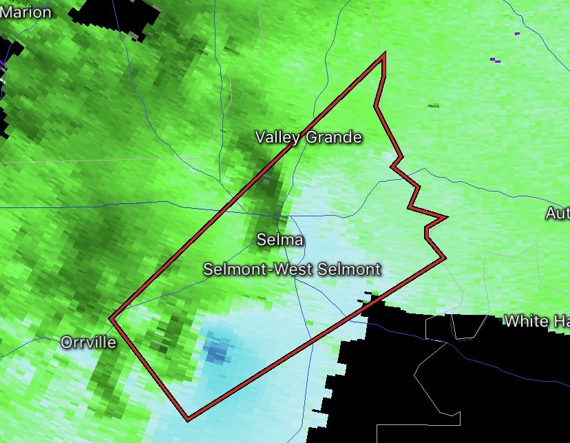
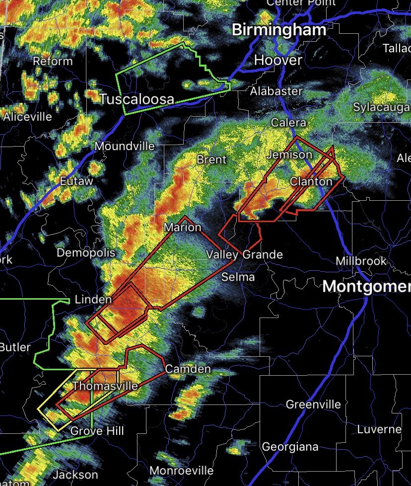
Ha! Not a TOR but Selma getting hammered again by a supercell. That’s just outright insane what they’ve gone through today. Would love to see a zoomed in loop from today’s radar from there.
-
 1
1
-
-
I mean come on is this the third time today Selma has at least had a decent shot at a tornado? Just ridiculous in terms of the probabilities of that happening... There was definitely that one confirmed earlier.
-
 1
1
-
-
3 minutes ago, codfishsnowman said:
So much rain in all those storms, what a nightmare. I don't know how the folks down there deal.
Choo choo the tornado train. F having this aimed down your doorstep.
-
Just now, cheese007 said:
We've got a looooooong way to go to talk about dodged bullets
Ya bad choice of words on my part, but looks like Jackson area could be good once the line passes through. One TOR warned cell on that line but not to impressive on velocity scans.
-
From earlier today. Looks pretty big but the base is obscured by the hill...from what I’m seeing these tornadoes don’t look super intense but there’s sure as hell a lot of touchdowns. That’s obviously a premature observation with a long way to go, hopefully it stays that way. Anyone else think MS might of kinda dodge a bullet as well? The main line of storms is getting ready to move through Jackson.
https://mobile.twitter.com/meteodon/status/1372299928018558980
-
47 minutes ago, vtrap90 said:
The severe aspect of this storm system right now in the south is sobering.
Yup, that’s all I’ve been watching from this system. Going to be a long evening down south and tomorrow looks nasty as well. I don’t give a crap about this storm here...screws over any of the ski areas from late season snow which is all I care about this time of year.
-
Damn, first time checking in today, real busy day at work but wow this is shaping up nasty. Some of those cells popping in MS are looking no bueno...won’t be surprised if the cell approaching mount olive produces soon.


April 2021 Discussion
in New England
Posted
Rebuilding our pack here in Hampton