

KoalaBeer
-
Posts
623 -
Joined
-
Last visited
Content Type
Profiles
Blogs
Forums
American Weather
Media Demo
Store
Gallery
Posts posted by KoalaBeer
-
-
5 minutes ago, SnowGoose69 said:
I just think its unlikely in 2024 the high res models would miss that degree of a capture this close in and now that its going to become a 4 I think it'll make it even harder for it to get pulled W of N til its well into GA though it might move 360-010 after landfall. I'd feel confident now saying it will pass E of ATL, would not put a mileage on it but would say at least 30. Ultimately not a massive error on the current track, it just seems big because it would make a huge difference in a big city.
Agreed. I guess that why I put capture in parentheses. I think the interaction will pull it more northward then some of the eastward solutions being thrown out there is all I’m saying. I like the St Marks call for landfall as a low end Cat 4. I certainly wouldn’t let my guard down in places like TLH.
-
 1
1
-
-
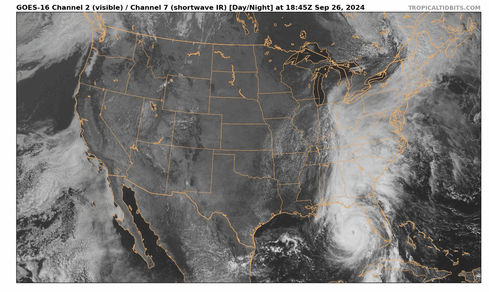
Zooming out and looking at the big picture is mesmerizing. Strongly recommend going to watch the loop and switching over to water vapor as well which highlights the interaction with the trough. Already hints of it getting “captured” which I think limits how far east this goes. Despite what others are saying I’ll stick with the NHC.
https://www.tropicaltidbits.com/sat/satlooper.php?region=us&product=wv_mid
-
3
-
-
5 minutes ago, BoulderWX said:
To be clear, I didn’t say that it hasn’t happened… I personally hadn’t seen official forecasts in my memory. That’s all…
Fair enough. It’s not super uncommon with these high end systems. Florence is another one that comes to mind that dropped a fairly widespread 20-30+ inches.
-
1
-
-
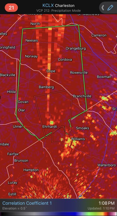
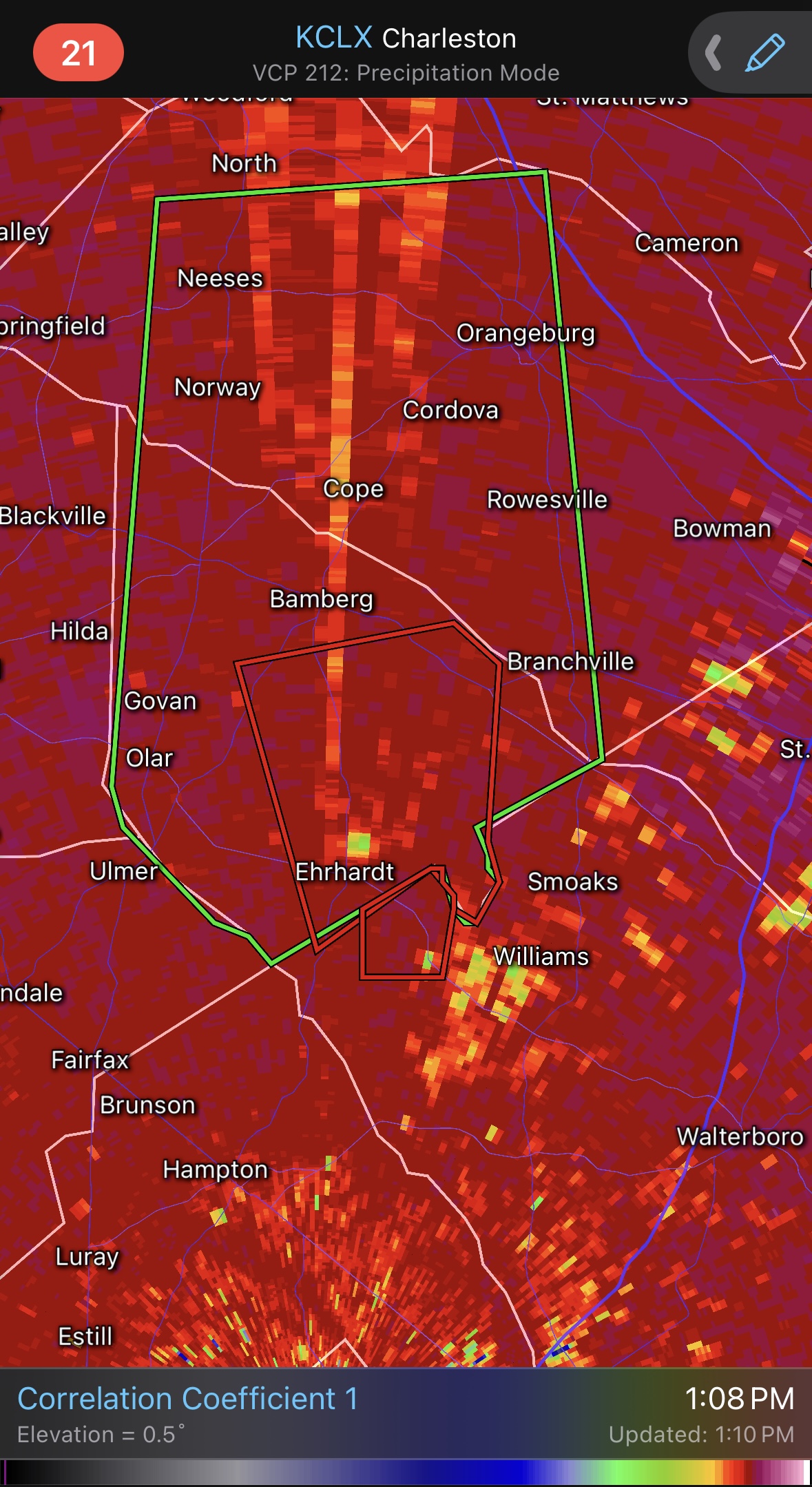
Tornado threat ramping up into the afternoon. CC drop on this one by Ehrhardt SC.
-
 2
2
-
-
26 minutes ago, BoulderWX said:
I have never seen a 20-30” official forecast. And honestly wouldn’t be surprised if some places surpass that. Incredible. Even if the worst case doesn’t pan out, which it hopefully won’t, this one will be historic in its own right.
-
3 minutes ago, Hotair said:
The satellite presentation suggests to me this is a large system. I know eyeballing is not encouraged in this forum but has anyone here opined as to the relative size of Helene to other gulf storms in recent past?
Straight from the mouth of the NHC. Just read the 5 pm forecast discussion.
https://www.nhc.noaa.gov/text/refresh/MIATCDAT4+shtml/242058.shtml
Of equal importance to the forecast intensity is Helene's forecast
size.  Helene's forecast radii are at the 90th percentile of
major hurricane size at similar latitudes, and therefore storm
surge, wind, and rainfall impacts will likely extend well
away from the center and outside the forecast cone, particularly on
the east side.
-
4
-
-
Wow, at work and did a quick radar check on my phone and that is quite the wall of TOR warnings across LA into TX. A few of them with a significant TDS on them.
-
11 minutes ago, 40/70 Benchmark said:
All systems need to be go with respect to not only the environment, but the structure....the importance of the latter is what many folks have underestimated. Post ERC systems often get like this with a broad core that never seems to recapture that tightly coiled vigor....the state that I refer to as "skunked". Beryl is in this state. Hopefully my 95 MPH landfall call isn't too aggressive.
Ya absolutely. Seen it time and time again. With enough time some systems can recapture it but that’s simply not the case here. Those broad cores can take quite a long time to reconsolidate into something that can RI. I like comparing it to some big severe weather days when people are drooling over those high STP maps. Sure there is a pristine environment for a violent TOR but the question is there a storm that is able to take advantage of it?
I think your call is good even if it comes in a little weaker, it’s pretty hard to hit the nail on the head with a system like this.
-
1
-
-
30 minutes ago, wncsnow said:
I think the dry air from the ULL has done as much or more damage than the land interaction.
Can’t argue with you there. Beryl kind of got the 1-2-3 whammy. Land interaction -> cool SSTs of the northern Yucatán -> dry air intrusion that was very apparent on WV loops.
-
1
-
-
21 minutes ago, 40/70 Benchmark said:
This has about 12 hours left. I am just about ready to remove the possibility of cat 2 from the table. I feel like it needed to be in a better position by now.
Agreed. Despite pretty much all systems being go for intensification up until landfall it’s still to broad. Some systems just can’t get it back together after land interaction. Almost looks like it has subtropical characteristics to it.
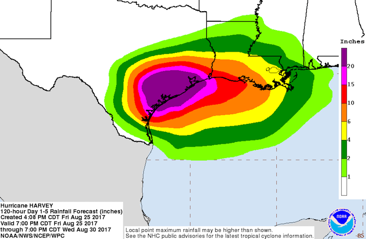
Still a dangerous storm for the TX coast and should intensify right up until landfall but I don’t think Beryl will be pulling a Harvey on us.
-
1
-
-
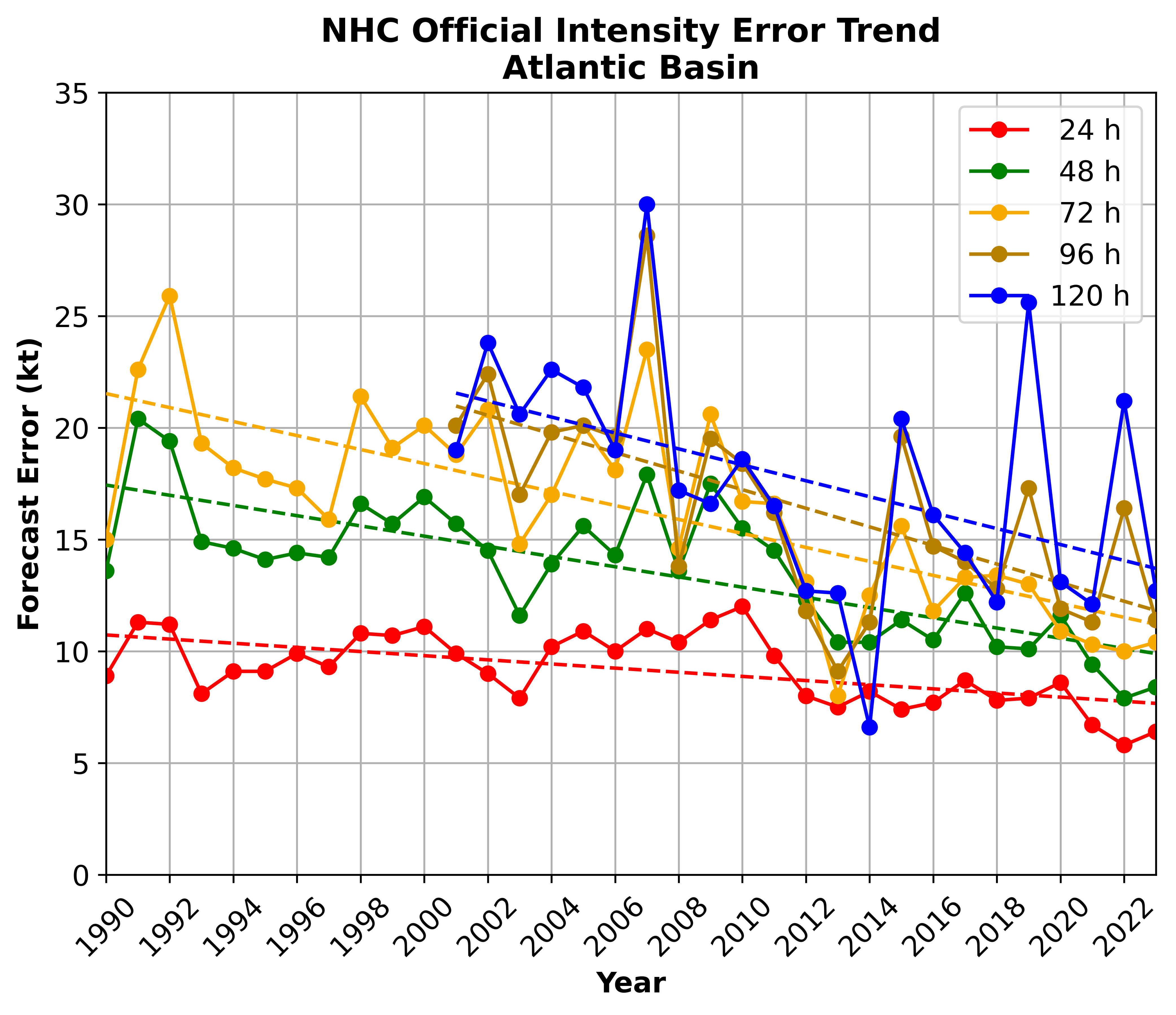
1 hour ago, wkd said:
Something has changed in the last 5-10 years regarding modeled changes in the increase in hurricane intensity although they are still good at forecasting track. This seems especially true once storms are in the gulf. I am a total novice in respect to tropical systems and the physics involved but I think forecasters need to increasingly use intuition/experience and not just models.
As an aside, kudos to 40/70 (Ray) for saying yesterday or the day before that he felt the models were too far south at land fall. Looks at this point he was correct.
I feel like people are saying stuff like this all the time without any data to back it up….
I think it’s easy for humans to remember the storms that over performed on intensity, and not so much the forecasts that were accurate or the storms that underperformed.
https://www.nhc.noaa.gov/verification/verify8.shtmlhttps://yaleclimateconnections.org/2023/06/which-hurricane-models-should-you-trust-in-2023/
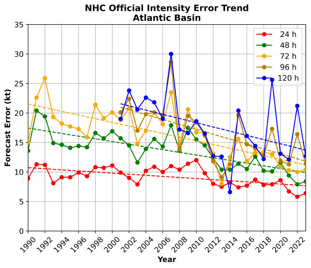
-
8
-
2
-
-
Some nasty looking cells popping in OK now in quite the favorable environment. At least the cell heading towards the OKC metro is looking on the downtrend as it might be getting robbed of its potential by surrounding storms.
-
7 minutes ago, Brian D said:
That looks like EF3 to 4 damage along the path. Brutal. Hope everyone made shelter.

Ya I don’t necessarily like tossing out numbers based of photos etc, but I’d bet my left nut this will be rated EF4+
Saw a few photos of asphalt ripped from the road as well.
-
Greenfield drone footage. No matter how many times I see it, it never ceases to amaze me how one home can be slabbed and houses a block away are relatively unscathed. Really high end damage, will have to see what the survey crews find.
-
 3
3
-
-
-
DOW is on that Greenfield IA storm. Probably going to get some wild data out of that storm. Appears the town might have just taken a direct hit.
-
Thunder and lightning here in Portland ME currently.
-
2
-
 1
1
-
-
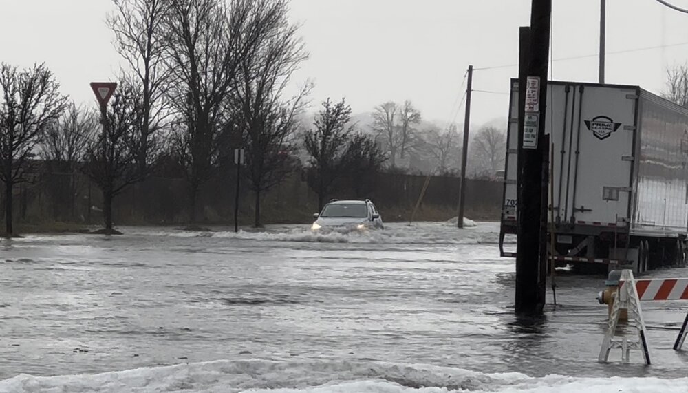
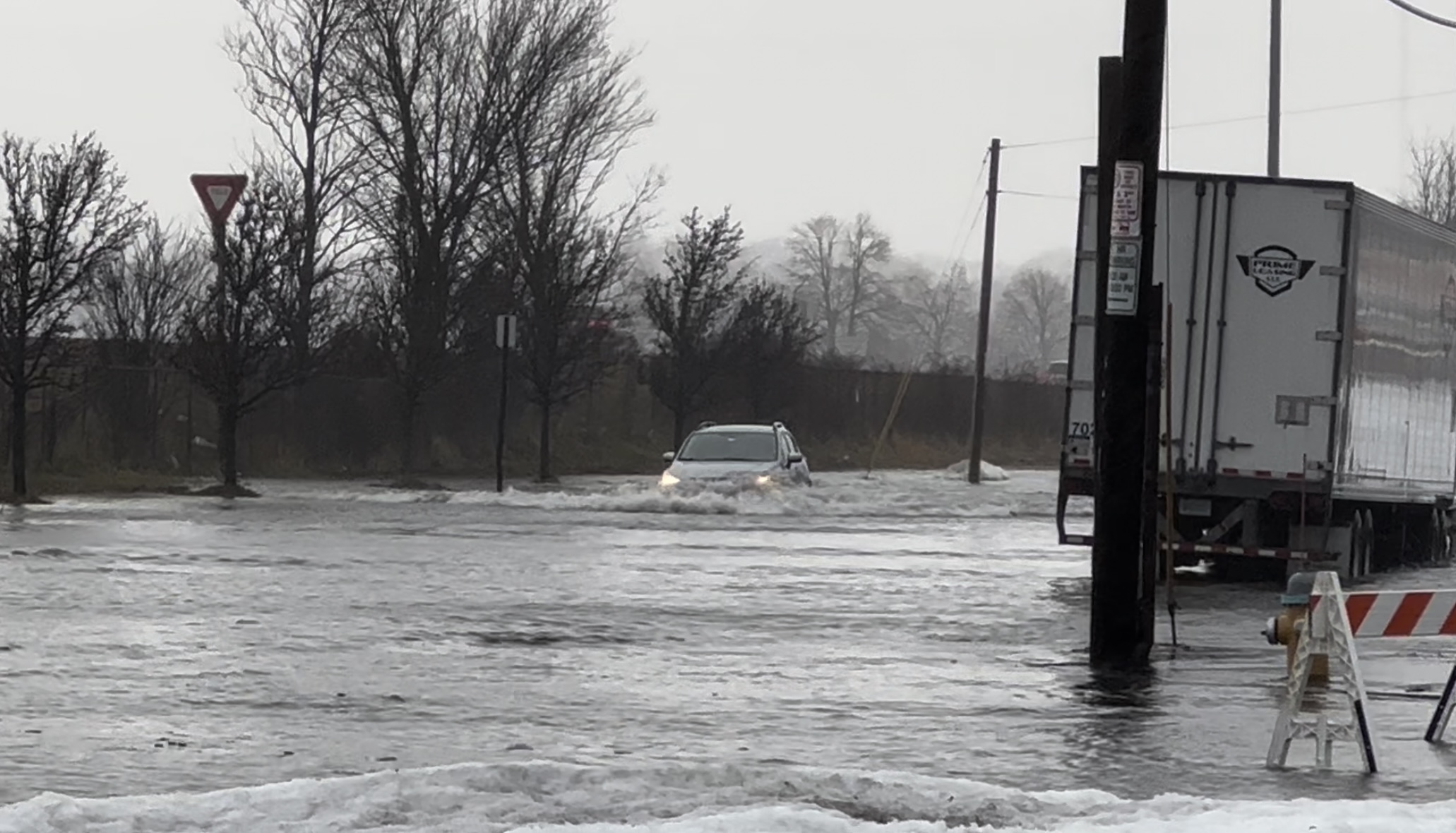
13.92 ft in Portland and rising. Starting to flood good down here at work.
-
9 minutes ago, CoastalWx said:
It sounds like this is getting pretty serious up in Portland.
12.82 ft and climbing. I work in the back cove so we’ll see how high it gets. Cinnamon Rainbows cam in Hampton is rocking.
https://www.cinnamonrainbows.com/surf-cam-report
https://tidesandcurrents.noaa.gov/stationhome.html?id=8418150
-
5
-
1
-
-
-
2 minutes ago, ICEHOCEY77 said:
HOLY SHIT. THEY INTERCEPTED.
That was wild, WTF with the two sedans who casually drove right by them as they intercepted.
-
Reed with a large tornado on the ground in NE.
Edit: I didn’t know they were in the dominator, they just took a direct hit. -
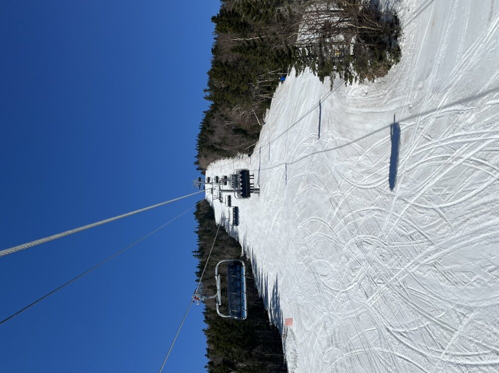
21 minutes ago, powderfreak said:
66F at summit beats record of 63F from 1968.

Scorcher here at Waterville but what a fun spring day.
-
3
-
-
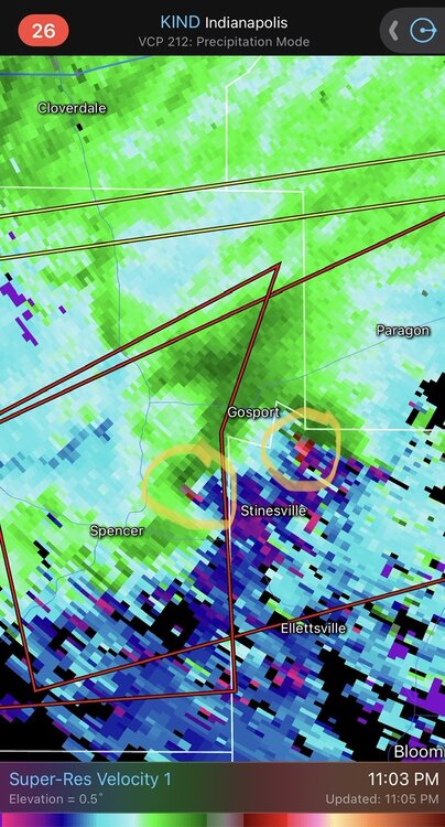
1 minute ago, Windspeed said:
Evident debris ball after hit on Spencer, Indiana.

Multiple? Wtf…
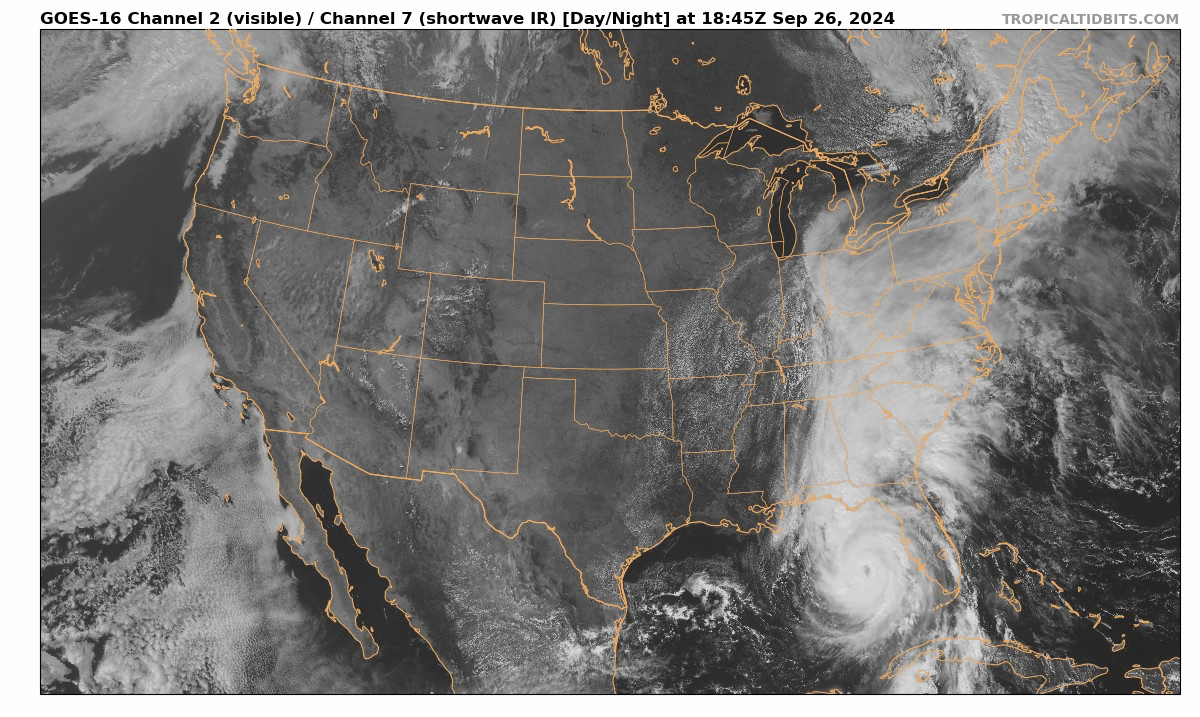


Major Hurricane Helene
in Tropical Headquarters
Posted
Uhh just check the NHC website..
https://www.nhc.noaa.gov/refresh/graphics_at4+shtml/154002.shtml?cone#contents