

KoalaBeer
-
Posts
606 -
Joined
-
Last visited
Content Type
Profiles
Blogs
Forums
American Weather
Media Demo
Store
Gallery
Posts posted by KoalaBeer
-
-
35 minutes ago, Hotair said:
You are correct. I shouldn’t have said underwater. They’ve been crushed with high winds but the storm surge is not what fort Myers is experiencing
edit: this is the video I had based my statement on. It claimed to be from punta gorda
https://twitter.com/YaCelacanto/status/1575247806889136143?s=20&t=10p9wRsEoX2GAPuBpEq5IQ
Im so confused by this post. Storm surge is exactly what Fort Myers is experiencing. Punta Gorda got blasted by those backside eyewall winds but looks like they avoided significant surge.
Also that video you posted has “City of Naples” written on the side of the door of the fire truck. People need to stop trusting these twitter posts from random accounts without verification.
-
 4
4
-
 2
2
-
-
18 minutes ago, Amped said:
A good analog would be Katrina/Camille both took very similar tracks and had some different impacts due to the size difference.
Huh? At least Camille went over western Cuba but the track similarities end there. Not many good analogs to go off of here in modern record keeping.


-
 1
1
-
-
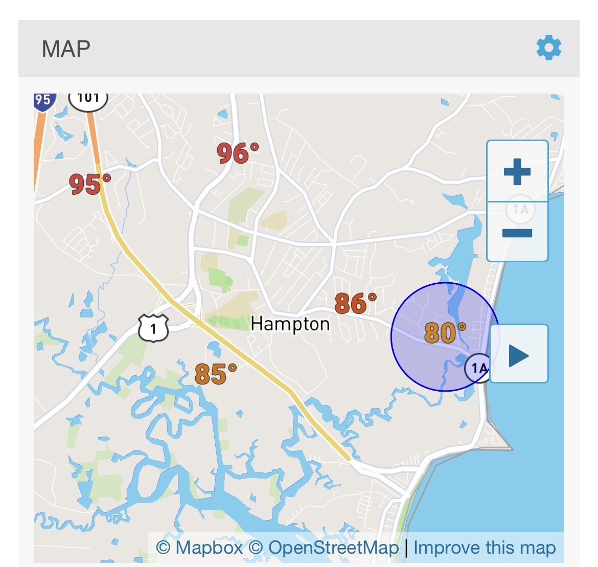
Scorching hot at my parents place in Hampton right by I-95 when I picked up the dog after work. A beautiful 80-85 right on the coast at my apartment a few miles away. Pretty crazy temperature gradient.

-
1
-
-
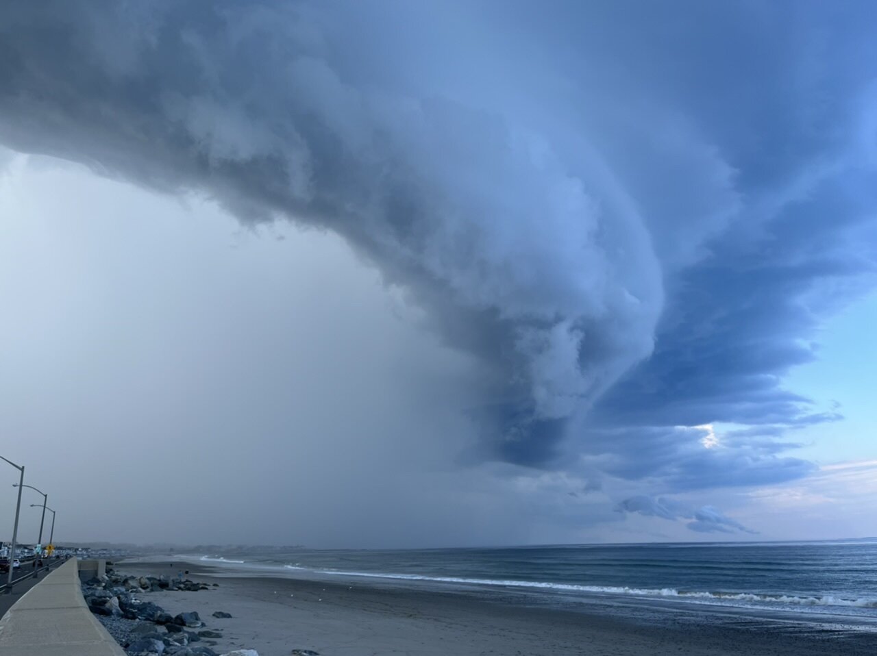
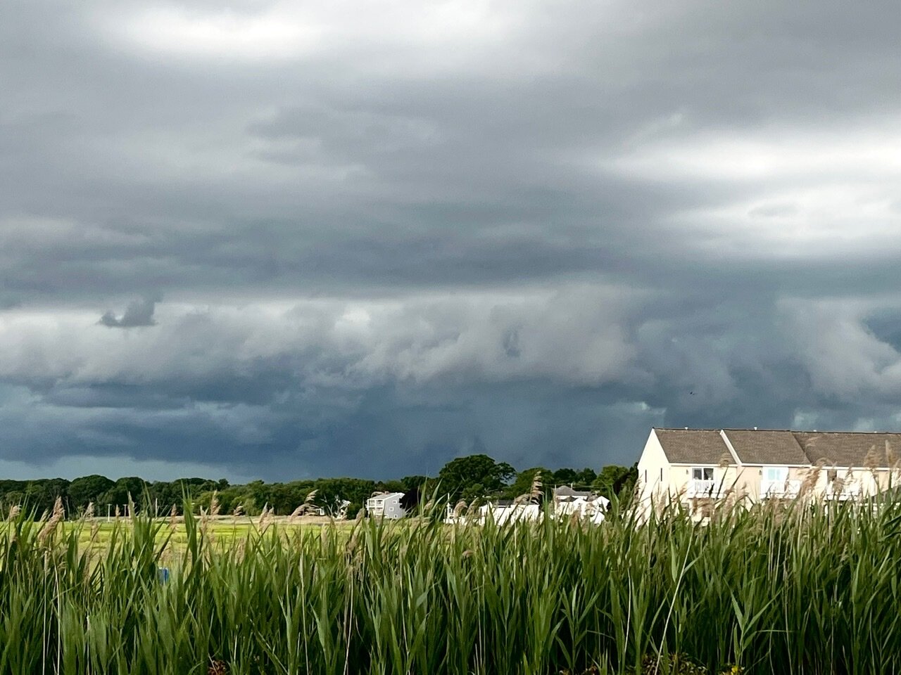
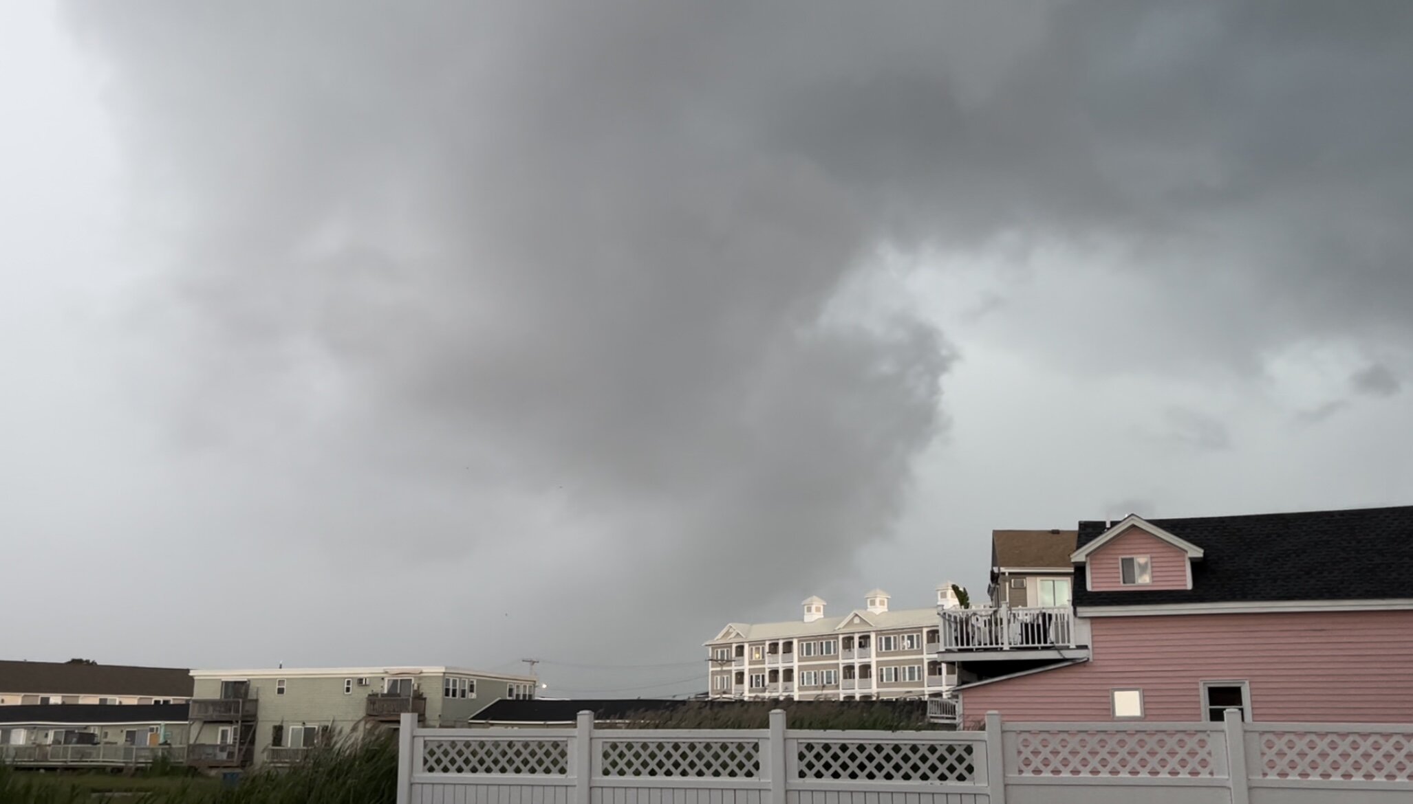
NH seacoast delivers again
-
4
-
-
-
3 minutes ago, CoastalWx said:
Hampton effect baby.
Getting hit pretty good here. Possible micro burst just north of me. That lowering was really surging as it passed by me.
-
3
-
-
4 hours ago, kdxken said:
No easy way to traverse the states.
Pretty much the main reason I do all my snowboarding in ME and NH. VT mountains are a bitch to get to from the seacoast.
Beautiful day here in Hampton with some nice 3ft waves. Might have to take the surfboard out for the first time this year now that the waters slightly warmer.
-
1
-
-
-
13 hours ago, powderfreak said:
I’ll be at Waterville on Tuesday for a Gear Day to test next year’s products… never been, looking forward to a foray into NH ski country.
Waterville is a good mountain. I should be there as well for the demo. Maybe we’ll have to meet up for a beer and a lap.
-
Wait George isn’t on board? Is hell freezing over?
Im happy as long as this stays snow for the ski areas. Conditions are good up there right now.
-
 1
1
-
-
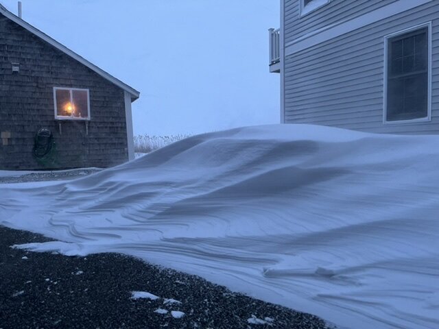
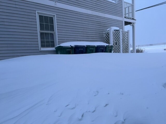
My driveway is either bare ground or a 4 foot drift.
-
13
-
-
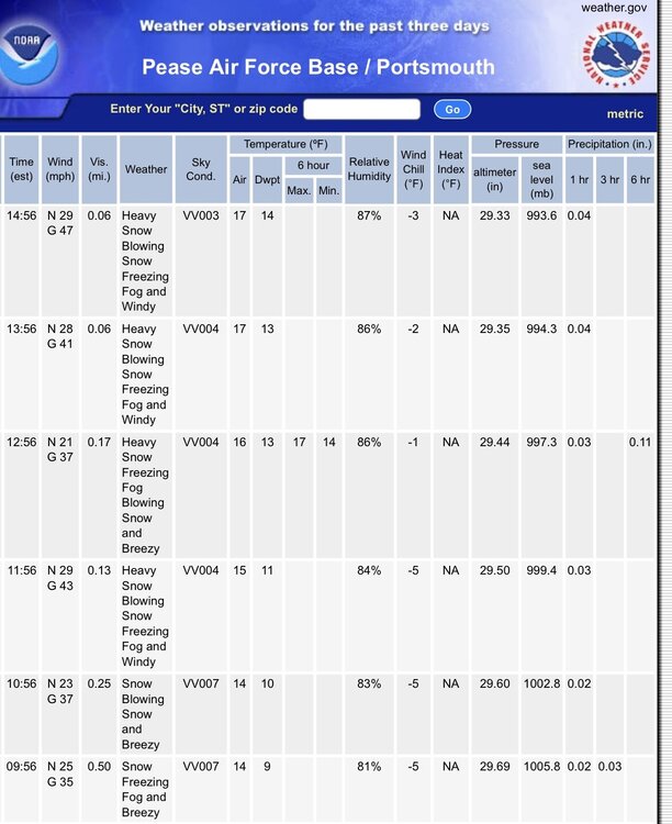
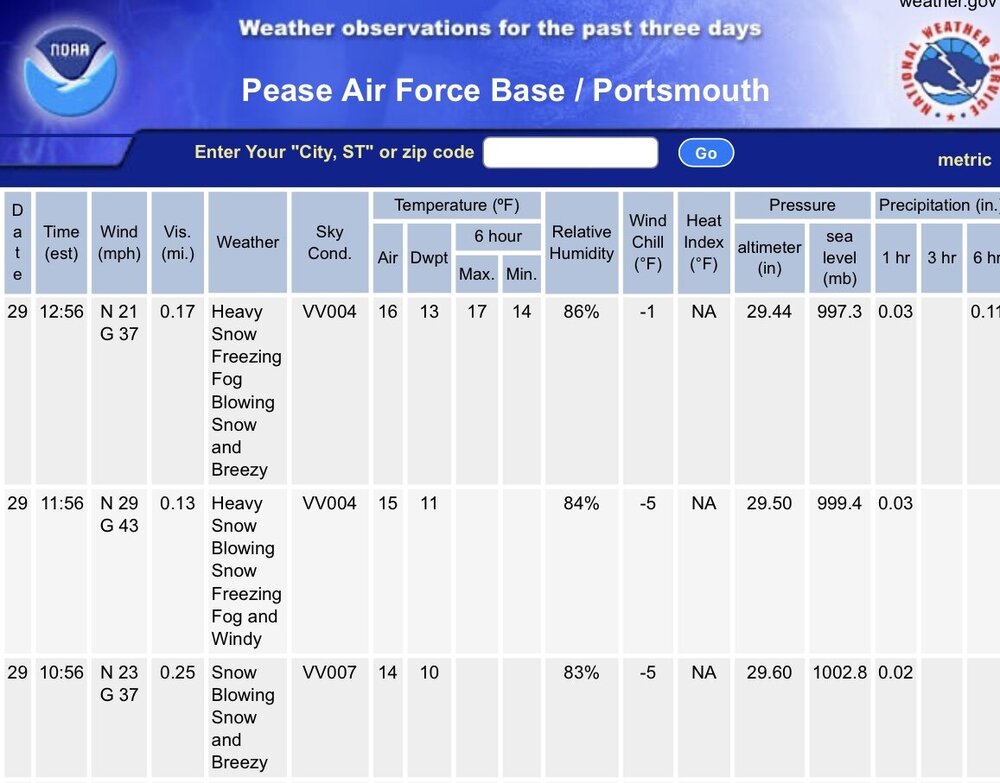
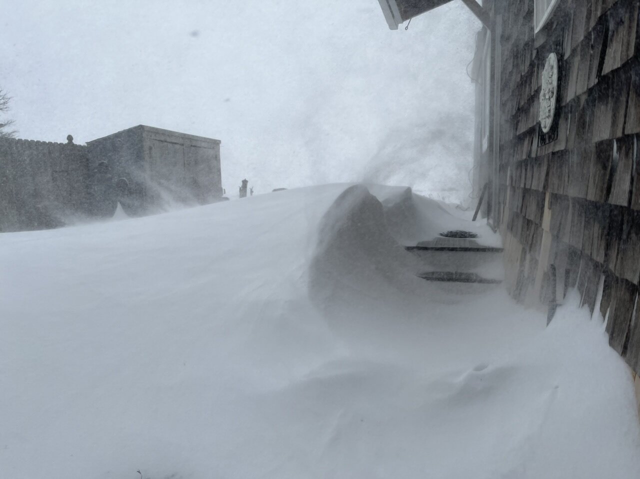
5+ hours of blizzard conditions now, .06mi visibility
 I couldn’t tell you if I got 15 inches of snow or 25 with the wind and drifting.
-
2
-
-
-
Another one from Hampton. Got to be pushing 2-3” / hr now.
-
4
-
-
Quick video from my place in Hampton NH
-
8
-
-
8 minutes ago, Syrmax said:
KGON Blizz criteria looks met...

Same at KPSM. Complete whiteout here on the coast of NH, not even going to bother and try a measure with the wind. Grass exposed in some areas and 3 foot drifts in others…
-
1
-
-
No snow here, but some serious coastal flooding in Hampton. Worst I’ve seen it in two years.

-
 2
2
-
-
8 minutes ago, CoastalWx said:
Hrrr gonna slay SE areas again.
Yikes.

-
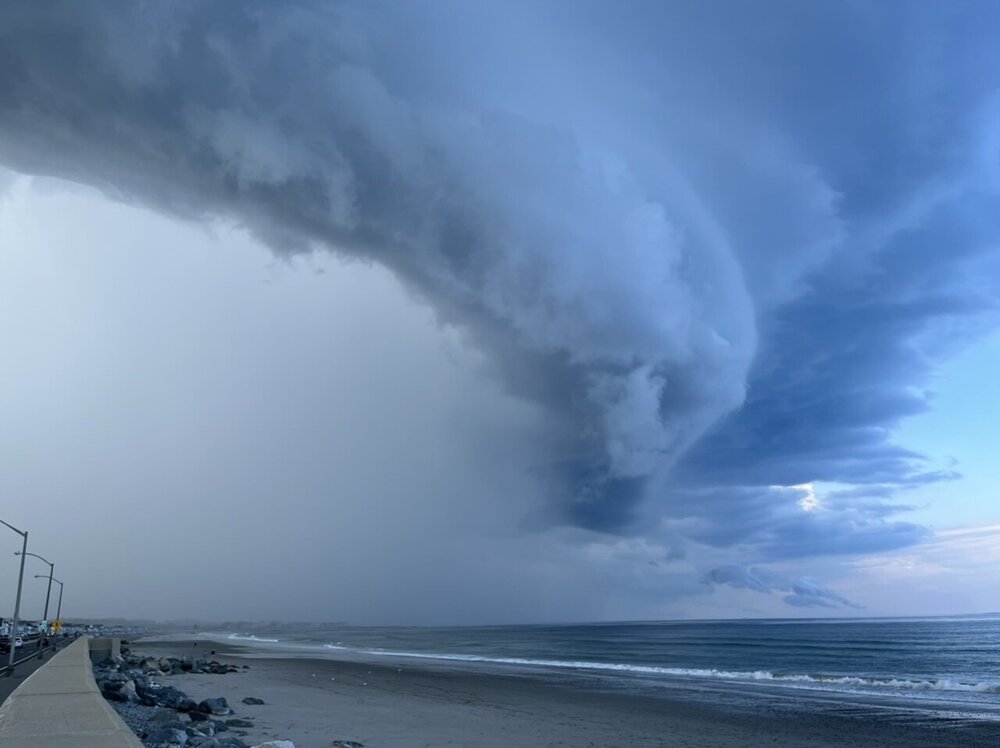
16 minutes ago, STILL N OF PIKE said:
Well, we got about 2 hrs for tornados to materialize
TOR warning in Maine. Looks pretty impressive on radar. Wouldn’t be surprised at all if it’s on the ground. Looks to have lofted some debris in the air on CC.
-
5 minutes ago, CoastalWx said:
Phil coming for Loon mtn. He's targeting all ski areas. Shut em down.
-
Looks like I’m in a pretty good spot today. Might take a drive over towards Manchester/Derry NH later if I’m done with work in time. That area could be nice, they typically get it good around there. Then again the seacoast is nice for the unrestricted views...
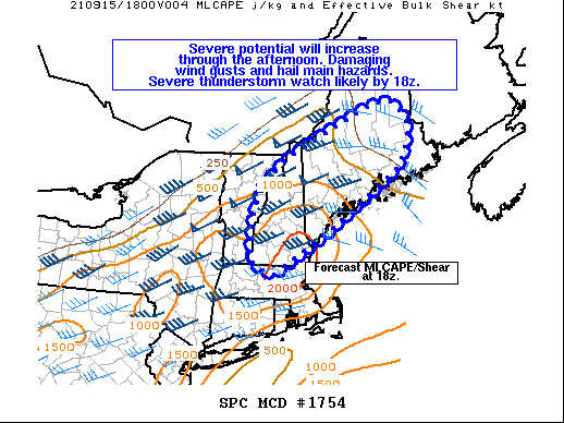
Mesoscale Discussion 1754
   NWS Storm Prediction Center Norman OK
   1059 AM CDT Wed Sep 15 2021

   Areas affected...portions of MA...NH and ME

   Concerning...Severe potential...Watch likely

   Valid 151559Z - 151800Z

   Probability of Watch Issuance...95 percent

   SUMMARY...Thunderstorms will increase in coverage and intensity
   through the afternoon. Damaging wind gusts and some hail will be the
   main hazards. A severe thunderstorm watch will likely be needed by
   18z.

   DISCUSSION...Convection is increasing ahead of a cold front near the
   Canadian border at midday. Stronger heating across southern New
   England to the south/west of a surface warm front has allowed for
   more rapid destabilization compared to much of ME, which remains
   under heavy stratus. As the upper trough shifts northeast through
   the afternoon, and the cold front slowly advances east/southeast,
   the warm front will lift northeast across ME. This will allow
   surface dewpoints from the mid 60s to near 70 F to overspread much
   of New England, and MLCAPE is forecast to increase to around
   500-1500 J/kg by mid-afternoon.

   Strong vertical shear is already in place over the region, with
   effective shear magnitudes greater than 40 kt evident in regional
   VWP data. Deep-layer southwesterly flow parallel to the surface
   front will support mainly lines/bowing segments with damaging wind
   gusts being the main hazard expected through this evening. However,
   southerly near-surface winds will contribute to somewhat enlarged
   low-level hodographs. Rich boundary-layer moisture also will support
   stronger 0-3 km instability from southern portions of VT/NH into far
   southern ME/northern MA. A tornado or two could occur across this
   area, especially if any more discrete cellular activity can persist.
-
1
-
-
5 hours ago, MJO812 said:
23 people have died in NJ and NY combined
RIP
No one thought it was going to be this bad. What a disaster.
Except for the fact this was very well predicted by the models, local NWS offices and the WPC alike. I can’t help but feel we need a major overhaul on how these extreme threats are broadcast to the public.
When a major blizzard comes through NYC travel is restricted to all non-emergencies...why wasn’t the same thing done here? It makes me really sad and angry that I think a lot of fatalities could have been prevented here if the threat was better conveyed. Jeff Masters post on YCC today hits the point pretty hard.
“
New York’s new governor, Kathy Hochul – forced to deal with every political leader’s nightmare, a weather disaster, after just one week in office – called the rain “far more than anyone expected.” In fact, despite many residents getting caught unaware, the potential for high-end flooding was amply predicted by the National Weather Service. A flash flood watch for the New York City area for Wednesday afternoon was issued by the local National Weather Service office an amazing 48 hours in advance: at 3 p.m. Monday. The watch warned that “widespread 3 to 5 inches of rain is forecast with locally higher amounts possible.”
By Tuesday afternoon, the NWS Weather Prediction Center had enclosed the New York area in a top-end high-risk area for flood-producing rains for Day 2, Wednesday. The Weather Prediction Center also noted that some locations had a 95% chance of seeing rainfall amounts that would be expected once a century or less.
It’s possible that distractions from other major news events pulled the focus away, or that users who rely mainly on icon-based depictions or brief messages from apps rather than narrative detail may not have grasped the extreme nature of the flood threat. Moreover, if residents of New York had heard only that “remnants of Ida” were approaching, they might not have seen the situation as being especially worrisome, especially after multiple flood events already this summer. Perhaps it’s time to reconsider how top-end flood threats are depicted and disseminated to an audience that may be inured to them.“
-
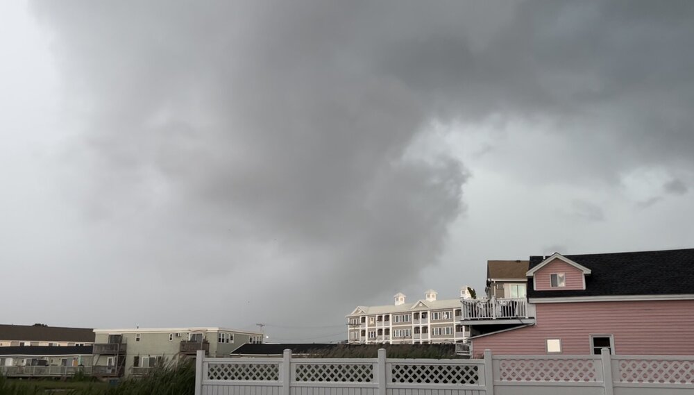
8 minutes ago, radarman said:
Very interesting analysis but given the low sample size of northeastern tornadoes specifically you might be comparing primarily against systems on the prairies/plains. Not totally clear if the lofted debris has the same characteristics everywhere... In other words are rain soaked deciduous leaves showing up the same as dry cottonwood leaves, grasses, roof shingles, etc? I don't know the answer
Good points. I don’t know the answer either. What I do know is a lot of his previous analysis has been within ~10mph or so of being correct. Either way I’d guess EF3 but as @CoastalWxjust said just because they are nice houses, doesn’t mean they were constructed all to well. It will be interesting to see the survey that’s for sure.
-
10 minutes ago, TauntonBlizzard2013 said:
any guesses on strength? Strong EF1 of EF2
Sam Emerson does some really good and highly accurate radar analysis of some of these TORs. You know it’s bad when the top three analogs were storms in MS, OK, and SD.
-
2
-

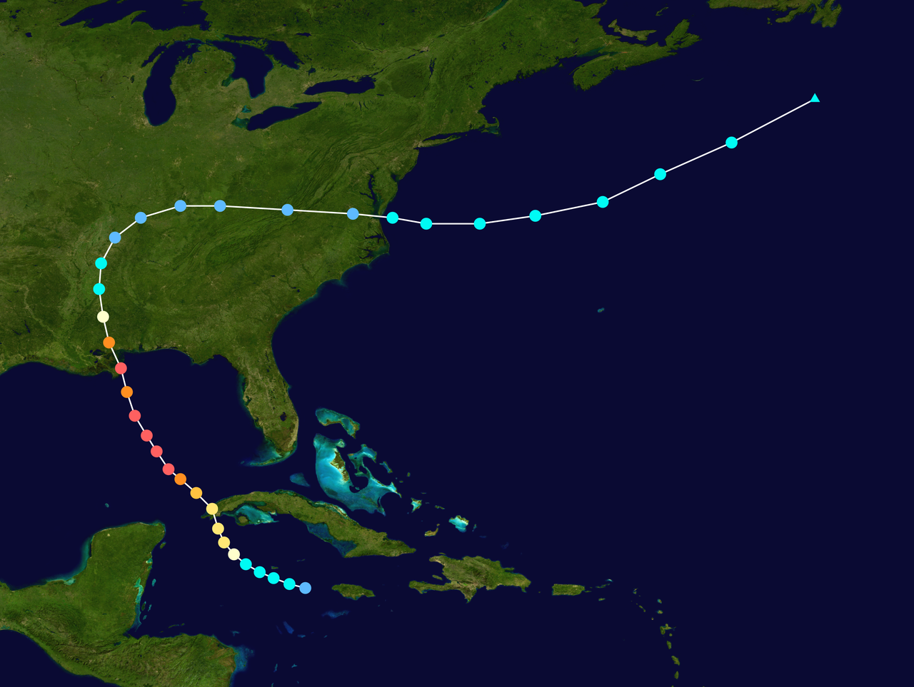


Hurricane Ian
in Tropical Headquarters
Posted
Haven’t seen much from there. Looking at obs winds were out of the N or NE all day so surge shouldn’t of been an issue. They got some hurricane force gusts however.
https://w1.weather.gov/data/obhistory/KSRQ.html