KoalaBeer
-
Posts
637 -
Joined
-
Last visited
Content Type
Profiles
Blogs
Forums
American Weather
Media Demo
Store
Gallery
Everything posted by KoalaBeer
-
TOR warning in Maine. Looks pretty impressive on radar. Wouldn’t be surprised at all if it’s on the ground. Looks to have lofted some debris in the air on CC.
-
-
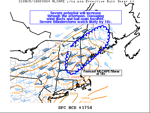
Looks like I’m in a pretty good spot today. Might take a drive over towards Manchester/Derry NH later if I’m done with work in time. That area could be nice, they typically get it good around there. Then again the seacoast is nice for the unrestricted views... Mesoscale Discussion 1754 NWS Storm Prediction Center Norman OK 1059 AM CDT Wed Sep 15 2021 Areas affected...portions of MA...NH and ME Concerning...Severe potential...Watch likely Valid 151559Z - 151800Z Probability of Watch Issuance...95 percent SUMMARY...Thunderstorms will increase in coverage and intensity through the afternoon. Damaging wind gusts and some hail will be the main hazards. A severe thunderstorm watch will likely be needed by 18z. DISCUSSION...Convection is increasing ahead of a cold front near the Canadian border at midday. Stronger heating across southern New England to the south/west of a surface warm front has allowed for more rapid destabilization compared to much of ME, which remains under heavy stratus. As the upper trough shifts northeast through the afternoon, and the cold front slowly advances east/southeast, the warm front will lift northeast across ME. This will allow surface dewpoints from the mid 60s to near 70 F to overspread much of New England, and MLCAPE is forecast to increase to around 500-1500 J/kg by mid-afternoon. Strong vertical shear is already in place over the region, with effective shear magnitudes greater than 40 kt evident in regional VWP data. Deep-layer southwesterly flow parallel to the surface front will support mainly lines/bowing segments with damaging wind gusts being the main hazard expected through this evening. However, southerly near-surface winds will contribute to somewhat enlarged low-level hodographs. Rich boundary-layer moisture also will support stronger 0-3 km instability from southern portions of VT/NH into far southern ME/northern MA. A tornado or two could occur across this area, especially if any more discrete cellular activity can persist.
-
Except for the fact this was very well predicted by the models, local NWS offices and the WPC alike. I can’t help but feel we need a major overhaul on how these extreme threats are broadcast to the public. When a major blizzard comes through NYC travel is restricted to all non-emergencies...why wasn’t the same thing done here? It makes me really sad and angry that I think a lot of fatalities could have been prevented here if the threat was better conveyed. Jeff Masters post on YCC today hits the point pretty hard. https://yaleclimateconnections.org/2021/09/northeast-pummeled-with-colossal-flooding-destructive-tornadoes/ “ New York’s new governor, Kathy Hochul – forced to deal with every political leader’s nightmare, a weather disaster, after just one week in office – called the rain “far more than anyone expected.” In fact, despite many residents getting caught unaware, the potential for high-end flooding was amply predicted by the National Weather Service. A flash flood watch for the New York City area for Wednesday afternoon was issued by the local National Weather Service office an amazing 48 hours in advance: at 3 p.m. Monday. The watch warned that “widespread 3 to 5 inches of rain is forecast with locally higher amounts possible.” By Tuesday afternoon, the NWS Weather Prediction Center had enclosed the New York area in a top-end high-risk area for flood-producing rains for Day 2, Wednesday. The Weather Prediction Center also noted that some locations had a 95% chance of seeing rainfall amounts that would be expected once a century or less. It’s possible that distractions from other major news events pulled the focus away, or that users who rely mainly on icon-based depictions or brief messages from apps rather than narrative detail may not have grasped the extreme nature of the flood threat. Moreover, if residents of New York had heard only that “remnants of Ida” were approaching, they might not have seen the situation as being especially worrisome, especially after multiple flood events already this summer. Perhaps it’s time to reconsider how top-end flood threats are depicted and disseminated to an audience that may be inured to them.“
-
Good points. I don’t know the answer either. What I do know is a lot of his previous analysis has been within ~10mph or so of being correct. Either way I’d guess EF3 but as @CoastalWxjust said just because they are nice houses, doesn’t mean they were constructed all to well. It will be interesting to see the survey that’s for sure.
-
Sam Emerson does some really good and highly accurate radar analysis of some of these TORs. You know it’s bad when the top three analogs were storms in MS, OK, and SD.
-
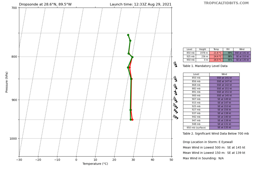
Latest dropsonde is very close to cat 5.
-
-
GYX been sleeping on the dense fog advisories. Probably can go ahead and pull the trigger on that one. ~200/300 yard visibility in Hampton. PSM reporting 1/4 mile. “Biggest conundrum at this point appears to be the possibility of another dense fog advisory tonight...“
-
Predictably boring on the NH seacoast. Some good waves out there but PSM didn’t even gust 30. Who would of thought the weather story of the day would be the flooding in Tennessee? 22 dead and 50 missing. Good thread here for those interested.
-
I’d say better spent then 20 years in Afghanistan... Odd thing to complain about with how populated of an area Henri will be affecting. Still thinking flooding is the biggest threat here.
-
Yup, was just about to say what everyone else did. That’s a worse solution for CT overall.
-
Hurricane Hunters are a busy crew tonight. Two planes in Henri and one in Grace. Curious to see what they find in Grace on the first pass. Wouldn’t be surprised if she is undergoing RI.
-
I think you just answered your own question. Looks like a non event for the NH seacoast. Just hoping for some good swell one day to get out surfing. Oceans been flat as a pancake lately.
-
Although I agree it’s exceptionally rare, how can he just cherry pick that one spot on that spacial grid scale? Just completely ignore the 9kts 10-15 miles to the east? Probably a fortunate thing Henri will be crawling over those colder SSTs however.
-
Look at shortwave IR at night to see the low level cloud patterns better. LLC is still at the northern edge of the deepest convection. Starting to get covered up better now however. MLC and LLC don’t look totally vertically stacked yet.
-
Looks like 5 recon flights into Henri tomorrow. 3 low-level and two upper. 3. OUTLOOK FOR SUCCEEDING DAY: A. CONTINUE 6-HRLY FIXES ON GRACE WHILE IT REMAINS A THREAT. B. BEGIN 6-HRLY FIXES ON HENRI AT 20/2330Z. C. TWO MORE NOAA 49 G-IV SYNOPTIC SURVEILLANCE MISSIONS AROUND HENRI FOR THE 21/0000Z AND 21/1200Z SYNOPTIC TIMES, DEPARTING KLAL AT 20/1730Z AND 21/0530Z. D. NOAA P-3 TAIL DOPPLER RADAR MISSIONS INTO HENRI DEPARTING KLAL AT 20/2000Z AND 21/0800Z. https://www.nhc.noaa.gov/text/MIAREPRPD_last.shtml
-
Henri holding on well but still getting sheared heavily. LLC looks partly exposed or right on the edge of convection.
-
Que Joe Bastardi tweeting in 3,2,1.....”Cat 4 inbound!”
-
Not that I’m aware of. Pretty much no historical analogs for this one. Nothing even remotely close to Bermuda has made landfall in New England before. Credit Bob Henson/Jeff Masters for the image over at YCC. Track of all tropical cyclones on record, going back to 1851, that passed within 120 nautical miles of Hartford, Connecticut, while still classified as hurricanes. (Image credit: NOAA Historical Hurricane Tracks)
-
Hahaha Bastardi give me a break. The same guy posting about the 3K NAM showing Fred getting down to 956mb before making landfall on the FL panhandle. Even to my amateur eyes it was obvious connective feedback. Why’s he so obsessed with using the NAM for tropical systems? For the clicks and likes? I trust not a single word out of that mans mouth at this point. Don’t care how much experience he has.
-

August Disco 2021. Do record dews continue?
KoalaBeer replied to Damage In Tolland's topic in New England
Speaking of flash flooding....go check out the southeast forum thread. NC getting nailed. Sign of things to come? -
EF2 on the Ocean county one. What a day for them.
-
Should be fun watching the storms develop in the upper Midwest tonight. PDS watch issued. Maybe one day I’ll see a derecho in New England. ...THIS IS A PARTICULARLY DANGEROUS SITUATION... * Primary threats include... Widespread damaging winds expected with scattered significant gusts to 90 mph likely Scattered large hail likely with isolated very large hail events to 2 inches in diameter possible A tornado or two possible
-
Fair enough. Definitely not impressive in terms of hail/lightning but I wasn’t expecting the wind, and I obviously respect your opinion as a met. Always hard to tell how localized the severe wind is with limited observations as well. Logan is pretty exposed and my apartment is as well.