SRRTA22
-
Posts
1,879 -
Joined
-
Last visited
Content Type
Profiles
Blogs
Forums
American Weather
Media Demo
Store
Gallery
Everything posted by SRRTA22
-

Sun July 11-Mon July 19 Pockets of FF/SVR and a modest heat wave
SRRTA22 replied to wdrag's topic in New York City Metro
Yeah the sky looked extremely menacing towards essex and union -
Sun July 11-Mon July 19 Pockets of FF/SVR and a modest heat wave
SRRTA22 replied to wdrag's topic in New York City Metro
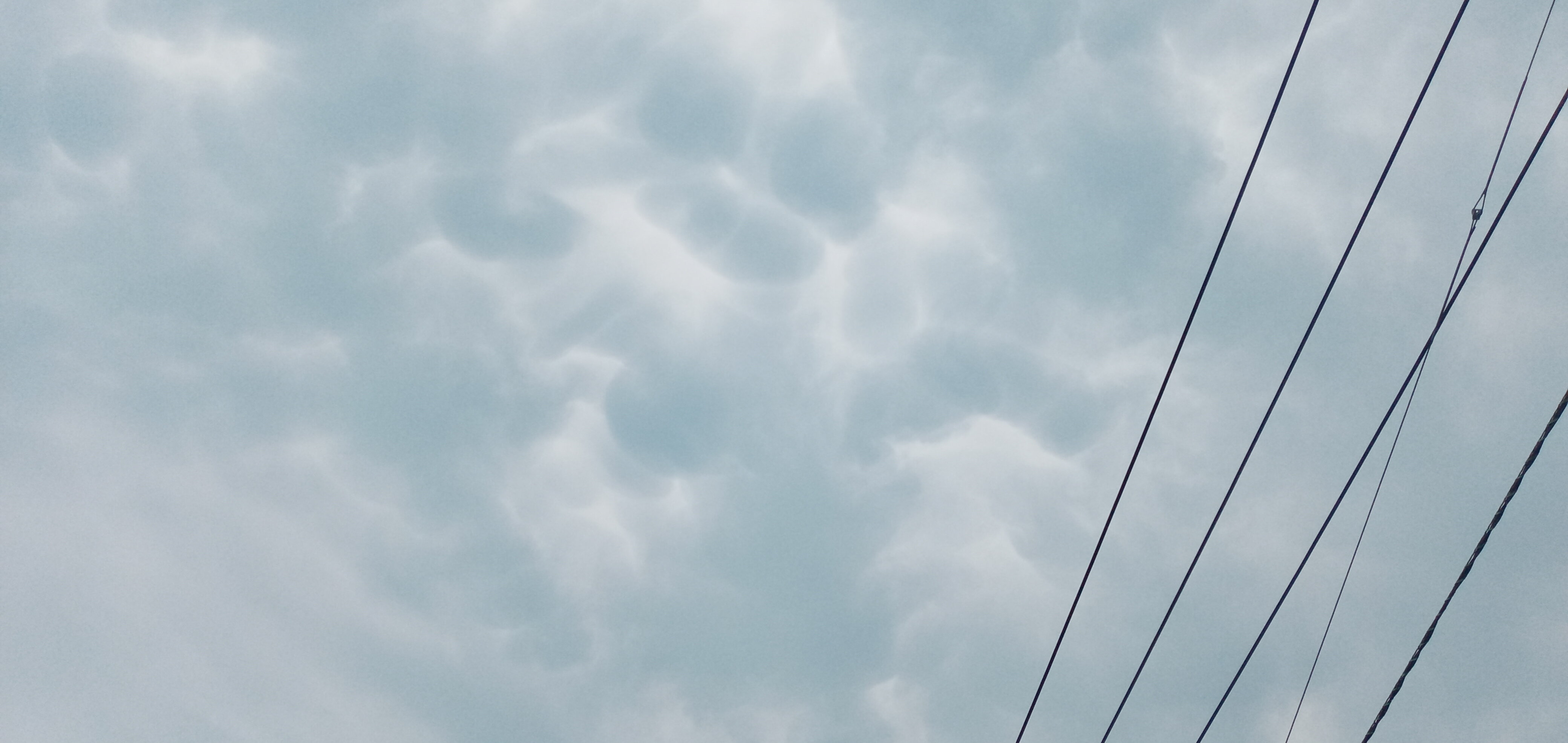
Some gnarly mammatus ahead of that line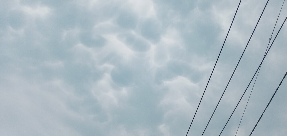
- 382 replies
-
- 1
-

-
- flash flooding
- severewx
- (and 1 more)
-
Sun July 11-Mon July 19 Pockets of FF/SVR and a modest heat wave
SRRTA22 replied to wdrag's topic in New York City Metro
To say tonight looks stormy might be an understatement -
Sun July 11-Mon July 19 Pockets of FF/SVR and a modest heat wave
SRRTA22 replied to wdrag's topic in New York City Metro
- 382 replies
-
- 9
-
-

-
- flash flooding
- severewx
- (and 1 more)
-
Sun July 11-Mon July 19 Pockets of FF/SVR and a modest heat wave
SRRTA22 replied to wdrag's topic in New York City Metro
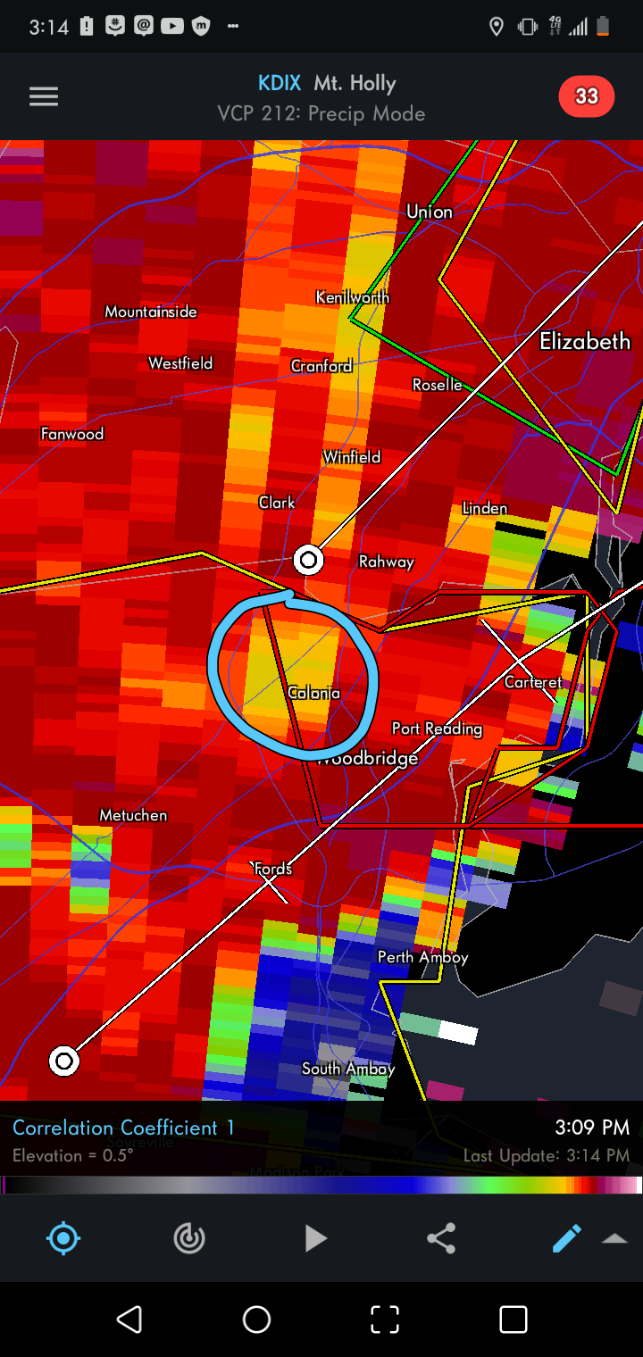
Anyone in Colonia? I think a TOR touched down there briefly- 382 replies
-
- 1
-
-
- flash flooding
- severewx
- (and 1 more)
-
Sun July 11-Mon July 19 Pockets of FF/SVR and a modest heat wave
SRRTA22 replied to wdrag's topic in New York City Metro
Um?
-
Sun July 11-Mon July 19 Pockets of FF/SVR and a modest heat wave
SRRTA22 replied to wdrag's topic in New York City Metro
Subsidence ^- 382 replies
-
- 2
-
-
-
- flash flooding
- severewx
- (and 1 more)
-
Sun July 11-Mon July 19 Pockets of FF/SVR and a modest heat wave
SRRTA22 replied to wdrag's topic in New York City Metro
Definite flooding in my area. Waiting for these CGs to calm down before even thinking of stepping outside and taking photos- 382 replies
-
- 1
-
-
- flash flooding
- severewx
- (and 1 more)
-
Sun July 11-Mon July 19 Pockets of FF/SVR and a modest heat wave
SRRTA22 replied to wdrag's topic in New York City Metro
.thumb.png.449d10ad70de0df88b76d62a65a49c5c.png)
- 382 replies
-
- 1
-
-
- flash flooding
- severewx
- (and 1 more)
-
Sun July 11-Mon July 19 Pockets of FF/SVR and a modest heat wave
SRRTA22 replied to wdrag's topic in New York City Metro
NWS 2:56pm: The Newark Airport just reported a 58 mph wind gust at 2:49 pm. Radar is also estimated 2 to 3 inches of rain in one hour. Flash flooding is likely occurring with this storm This is the exact time where winds went crazy here in JC ; Likely downburst That HREF model posted yesterday seems on point and Im concerned now- 382 replies
-
- 1
-
-
- flash flooding
- severewx
- (and 1 more)
-
Sun July 11-Mon July 19 Pockets of FF/SVR and a modest heat wave
SRRTA22 replied to wdrag's topic in New York City Metro
Winds just went insane here holy ****- 382 replies
-
- 2
-
-
- flash flooding
- severewx
- (and 1 more)
-
Sun July 11-Mon July 19 Pockets of FF/SVR and a modest heat wave
SRRTA22 replied to wdrag's topic in New York City Metro
Its really trying to wrap around the seabreeze.thumb.png.f59f00d166fedaa8d3d9ee39cdeecee4.png)
-
Sun July 11-Mon July 19 Pockets of FF/SVR and a modest heat wave
SRRTA22 replied to wdrag's topic in New York City Metro
That storm is trying so hard lol -
Sun July 11-Mon July 19 Pockets of FF/SVR and a modest heat wave
SRRTA22 replied to wdrag's topic in New York City Metro
Elevated as of now.png.d65e063e0ecb188d127141d7cac5edc4.png)
-
Sun July 11-Mon July 19 Pockets of FF/SVR and a modest heat wave
SRRTA22 replied to wdrag's topic in New York City Metro
PRECAUTIONARY/PREPAREDNESS ACTIONS... For your protection move to an interior room on the lowest floor of a building. Continuous cloud to ground lightning is occurring with this storm. Move indoors immediately. Lightning is one of nature`s leading killers. Remember, if you can hear thunder, you are close enough to be struck by lightning. Torrential rainfall is occurring with this storm, and may lead to flash flooding. Do not drive your vehicle through flooded roadways. && LAT...LON 4069 7425 4087 7401 4078 7392 4078 7394 4077 7394 4074 7396 4072 7396 4072 7397 4064 7417 4065 7419 4063 7420 TIME...MOT...LOC 1817Z 234DEG 16KT 4070 7416 TORNADO...POSSIBLE HAIL...1.00IN WIND...70MPH -
Sun July 11-Mon July 19 Pockets of FF/SVR and a modest heat wave
SRRTA22 replied to wdrag's topic in New York City Metro
Tornado possible tag on that cell now -
Sun July 11-Mon July 19 Pockets of FF/SVR and a modest heat wave
SRRTA22 replied to wdrag's topic in New York City Metro
Okay, that storm is most definitely trying to do something sketchy over Elizabeth -
Sun July 11-Mon July 19 Pockets of FF/SVR and a modest heat wave
SRRTA22 replied to wdrag's topic in New York City Metro
That storm near Elizabeth looks like its trying to get some rotation? Very broad right now Right along the sea-breeze. so some localized veering? Watching intently -
Sun July 11-Mon July 19 Pockets of FF/SVR and a modest heat wave
SRRTA22 replied to wdrag's topic in New York City Metro
Nams been consistent with it too -
Sun July 11-Mon July 19 Pockets of FF/SVR and a modest heat wave
SRRTA22 replied to wdrag's topic in New York City Metro
Thanks for blessing our subforum with great insight and forecasts Walt. Youve been killing it these last few years. Tomorrow looks really interesting as youve stated. With a much needed and much deserved break after. What a month.- 382 replies
-
- 2
-
-
- flash flooding
- severewx
- (and 1 more)
-
Sun July 11-Mon July 19 Pockets of FF/SVR and a modest heat wave
SRRTA22 replied to wdrag's topic in New York City Metro
What do you want them to do, issue a FFW for one or two counties? The ffw is warranted. Some places will miss and some places may flood. -
Sun July 11-Mon July 19 Pockets of FF/SVR and a modest heat wave
SRRTA22 replied to wdrag's topic in New York City Metro
Its hard to see but that model wants to drop 6"+ right over my hood Thankfully its difficult to pinpoint convection. Extremely concerning -
Sun July 11-Mon July 19 Pockets of FF/SVR and a modest heat wave
SRRTA22 replied to wdrag's topic in New York City Metro
Had the benefit of feeling that nice outflow from the monmouth storm without the rain. Felt nice while it lasted -
No where near the summer of 09
-
Sun July 11-Mon July 19 Pockets of FF/SVR and a modest heat wave
SRRTA22 replied to wdrag's topic in New York City Metro
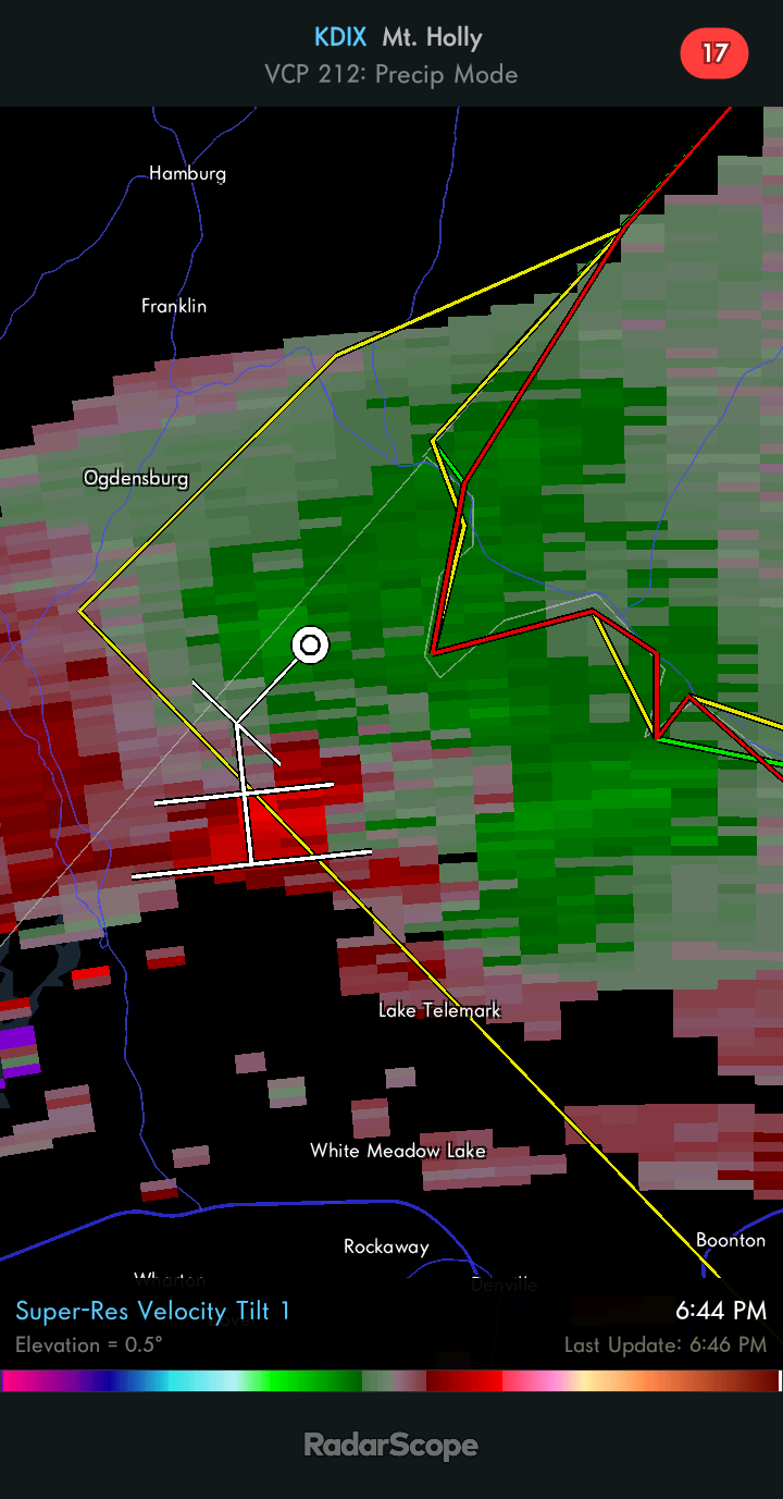
The rotation looks to have redeveloped outside the warning area, just north of Lake Telemark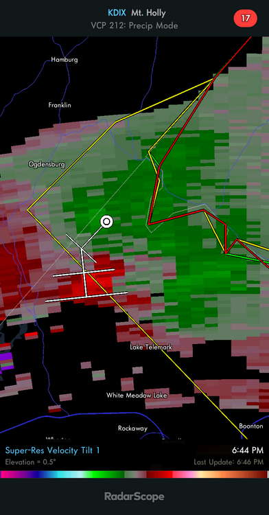
- 382 replies
-
- 1
-
-
- flash flooding
- severewx
- (and 1 more)
.png.f84a84eb42d1f11639d5d11db7344bb3.png)
.png.79bd0fcae1355c83674795a6c8bcc947.png)