

George BM
-
Posts
2,610 -
Joined
-
Last visited
Content Type
Profiles
Blogs
Forums
American Weather
Media Demo
Store
Gallery
Posts posted by George BM
-
-
Coffee IPA is the best beer of all time! Right Mattie g?
-
It hasn't rained for more than 24 hours. My yard is now only spongy instead of spongy with puddles and it doesn't seem like it will rain again until at least Tuesday. If this keeps up I may, dare I say, be able to mow the lawn this weekend.
This drought means business folks. Water your thirsty lawns. Make sure your outdoor plants can survive until at least Tuesday... if it even rains then. Hurry... before this dryness reaps their poor little souls and they go haunting you in your dreams turning them into nightmares. Once that happens they will take control of your soul and you will all go into your yards and plant yourselves into the ground drinking up any rain that comes by. But then once it becomes colder the cold will reap your souls just like it does to the grass every winter. But with that having happened you will miss all the great snowstorms, snowicanes and a surprise tropical that will annihilate the region this winter.
So please... don't forget to water your lawns and gardens.
EDIT: I was able to mow the lawn this afternoon! Unreal.
-
 1
1
-
-
DCA: 11/16
BWI: 10/18
IAD: 10/18
RIC: 11/22
IAD October precip: 6.67"
-
 1
1
-
-
-
-
...I got nothing.
-
Fairly wet start to Meteorological Fall in general.
-
Thread created August 23, 2011 at 1:51pm edt.
Earthquake occured August 23, 2011 at 1:51pm edt.
I'm just picturing Kenny weenieing bigly ninjaly whipping up the earthquake thread while mass chaos ensues all around him.
-
2
-
-
A slightly smokey sunset this evening.
-
6 minutes ago, MN Transplant said:
That strike was close. I may walk the neighborhood later to see what I find.

Is that lightning detector actually accurate with the strike locations?
-
The storm west of Manassas actually seemed to have some weak rotation when it was in eastern Fauquier County.
-
7 hours ago, Cobalt said:
Absolutely raining buckets right now. Loud thunder
28 minutes ago, BlizzardNole said:Woke up to thunder at 2:30 am and checked Radarscope -- warned t-storm slipping just south through Gaithersburg/Rockville. Picked up a big 0.08.
Yeah the thunder woke me up around 2:10am this morning. Got brief heavy rain/ gusty winds in Herndon, VA. One of my first thoughts looking at the radar and seeing a nice little bow-echo moving thorugh was: "If it had come through during the afternoon hours with steeper low-level lapse rates..."
-
1
-
-
3 hours ago, mappy said:
weve got what we think is a raccoon eating all our hummingbird nectar. have had to refill the damn feeder three days in a row now, in the morning, as its gone overnight.
Is it at the top of a poll? Because if it is you can butter/oil/grease the poll up and watch the show.
-
Wet.
-
Bring it on Mother!
-
The GFS is further west...for now.
-
3 hours ago, yoda said:
In September?
Late August through the first half of September. If it were peak season with the upcoming pattern of a high amplitude trough with the trough axis just west of the Appalachian Mountains, I would think that we would be talking about tropical systems tracking along or up the eastern seaboard potentially giving us decent impacts.
-
1 hour ago, frd said:
For visuals
and this
Now if we could have this pattern 5-8 weeks later...
-
73/71 IAD
-
Not an expert but... a hypothesis of mine is that the dynamics that would warrant us being under a higher risk (particular with west to east ring of fire type low pressure systems ) often allow the previous day's storms, which would otherwise die out and leave us with only nuisance cloud debris that morning, to survive the overnight trek through the Ohio Valley and cross the Appalachian Mountains into our region by or just after dawn (June 13, 2013,... June 23, 2016 (though that event might've been a wee bit south to start)) and mess up our instability by shifting it south. Sometimes it can take longer than modeled or longer than the SPC anticipated for the atmosphere to recover enough to allow for good afternoon/evening storms for us.
With the deeper troughs that can warrant higher risk days for us cloud debris from storms that outrun the cold front and/or the lift available in general can often lead to cloud cover that is extensive enough to tamper down the intensity of storms that form from what was expected though the strong lift, especially near the front, can still allow storms to form more often than in the case above.
Like I said I'm no expert. I'm just an amateur and this is my opinion based on what I've observed over the past several years. Weather is very complicated and I know that there are many other variables to consider that I didn't touch on.
-
35 minutes ago, Cobalt said:
wow!
Where's @Jebman?
-
Eskimo Joe intrigued while Yoda is 'meh'?!

What universe am I in and how do I get back to the correct one?
-
1
-
5
-
-
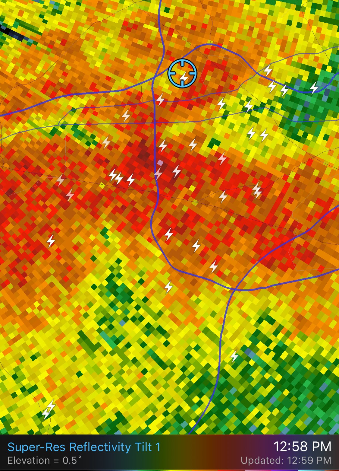
Lots of convective models are actually hinting at a thunderstorm cluster affecting at least parts of the sub forum tomorrow afternoon with fairly decent CAPE (especially southwest).
-
The Severe Thunderstorm Watch includes the District now.

WATCH COUNTY NOTIFICATION FOR WATCHES 84/85
NATIONAL WEATHER SERVICE BALTIMORE MD/WASHINGTON DC
504 PM EDT SAT MAY 12 2018

DCC001-MDC031-033-VAC013-059-510-600-610-130300-
/O.EXA.KLWX.SV.A.0084.000000T0000Z-180513T0300Z/

THE NATIONAL WEATHER SERVICE HAS EXTENDED SEVERE THUNDERSTORM
WATCH 84 TO INCLUDE THE FOLLOWING AREAS UNTIL 11 PM EDT THIS
EVENING

THE DISTRICT OF COLUMBIA

IN MARYLAND THIS WATCH INCLUDES 2 COUNTIES

IN CENTRAL MARYLAND

MONTGOMERY            PRINCE GEORGES

IN VIRGINIA THIS WATCH INCLUDES 5 COUNTIES

IN NORTHERN VIRGINIA

ARLINGTON             CITY OF ALEXANDRIA    CITY OF FAIRFAX
CITY OF FALLS CHURCH  FAIRFAX

THIS INCLUDES THE CITIES OF ALEXANDRIA, ARLINGTON, ASPEN HILL,
BETHESDA, BOWIE, CAMP SPRINGS, CHANTILLY, CLINTON, COLLEGE PARK,
FAIRFAX, FALLS CHURCH, GAITHERSBURG, GERMANTOWN, GREENBELT,
HERNDON, LAUREL, MCLEAN, POTOMAC, RESTON, ROCKVILLE,
SILVER SPRING, SUITLAND-SILVER HILL, AND WASHINGTON.

$$


October Discobs Thread
in Mid Atlantic
Posted
Falling temperatures. Falling humidity. Falling leaves. Falling sun angles.