
PowderBeard
-
Posts
2,027 -
Joined
-
Last visited
Content Type
Profiles
Blogs
Forums
American Weather
Media Demo
Store
Gallery
Everything posted by PowderBeard
-
Forgot about that. Given the Lindros brothers always had concussion issues, seems like a great trade other than Forsberg's appendix bursting during the 2001 cup run.
-
Need to take out equity to buy plywood for boarding up the windows.
-
Prior to the latest ICON if the high was modeled over Nova Scotia as opposed to NB a more eastern landfall into CT/RI/SE MA was modeled. Trough to the west for more of a tug?
-
Smidge west and weaker. Not much of a precip field. PVD will be closing up the hurricane barrier.
-
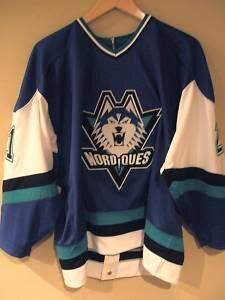
It's wild to look at the talent on that Nords team when they moved to Colorado. Joe Sakic Peter Forsberg Owen Nolan - who they traded for Ozolinsh They traded Mats Sundin for Wendel Clark (ugh), would trade Clark for Claude "The Turtle" Lemieux Not to mention the other names that would help Colorado win cups (e.g., Foote, Deadmarsh, Ricci, Kamensky).
-
All we need now is 0z to start pulling the rug, 6z put it OTS, meltdowns all day tomorrow, then the 18z to bring it all back. Good prep for winter.
-
Seriously, they have been passed up multiple times now but they have the 2015 arena. Twitter is abuzz about Kansas City or Portland. No way for KC and let's see Seattle work before another PNW team. Plus, I want to see these jerseys actually get worn.
-
Powder skis (115 waist) in the east are best for when 10-14" falls on bare ground, keeps you up above the rocks lol. I like 95-100mm for a daily driver, especially in bumps.
-
For hockey fans, Glendale opting out of arena lease after this season. Let's go Nordiques! https://theathletic.com/2778340/2021/08/19/point-of-no-return-glendale-to-boot-coyotes-from-gila-river-arena-after-2021-22-season/
-
All about the clicks and views. A 927mb looking buzzsaw on the 3km will get peoples' attention.
-
This is boggling my mind. Every model keeps it so compact and not taking on ET features. If it was moving 30+ mph from off the Carolinas to SNE I could see it, but being a slow mover and not taking on ET characteristics makes me think models are clueless.
-
NAM doing NAM things. 12z 975mb through 12z Sat vs. 992mb on the 6z.
-
This is what I'm watching. Tonight's updates will have people panicking or weenies saying "it can still ______."
-
Was surprised to see this as well. Will be going down the rabbit-hole reading about ET transitions this morning.
-
August Disco 2021. Do record dews continue?
PowderBeard replied to Damage In Tolland's topic in New England
Seeing a couple WU stations west of you reporting 4.5"+. You'll be there soon. -
August Disco 2021. Do record dews continue?
PowderBeard replied to Damage In Tolland's topic in New England
Winds really picking up. Neighbors will be calling a tree service. There is an 80' dead oak that snapped about 30' up and the remainder is resting on another tree. It rolls off and about 20' of it is on their roof. -
August Disco 2021. Do record dews continue?
PowderBeard replied to Damage In Tolland's topic in New England
Flooding and uprooting incoming. -
Even farther north in Maine, the snowstorm's effects remained disastrous; following its passage, a 60 acres (240,000 m2) timber lot at Thomaston was nearly entirely uprooted, clearing a massive forested area and making towns from great distances away, previously obstructed, suddenly visible.[19] The effect of the storm was so pronounced that, according to Sidney Perley, "people felt as if they were in a strange place".[27] The storm was particularly severe on the Atlantic coast, especially in Kennebec, Wiscaset, Berwick, Kittery, and York, causing moderate destruction and killing several cattle. However, at Portland, the hurricane was less severe and its impact was minimal.[2]
-
The social media hype train is running so fast by tomorrow night it will be another Snowicane of 1804.
-
Henri is making the "prom night promise".
-
If seals can get up the CT River to Holyoke, so can surge lol https://www.westernmassnews.com/news/seal-sighted-along-connecticut-river-in-holyoke/article_bbe401f6-7dbd-11e9-9fcb-f7f5bdf558aa.html
-
Someone needs to sacrifice a chicken. Is Kevin Costner hammered for this "Field of Dreams" game interview? Doesn't sound right.
-
Never seen clouds moving in so fast.


