

tunafish
-
Posts
2,043 -
Joined
-
Last visited
Content Type
Profiles
Blogs
Forums
American Weather
Media Demo
Store
Gallery
Posts posted by tunafish
-
-
4 minutes ago, The 4 Seasons said:
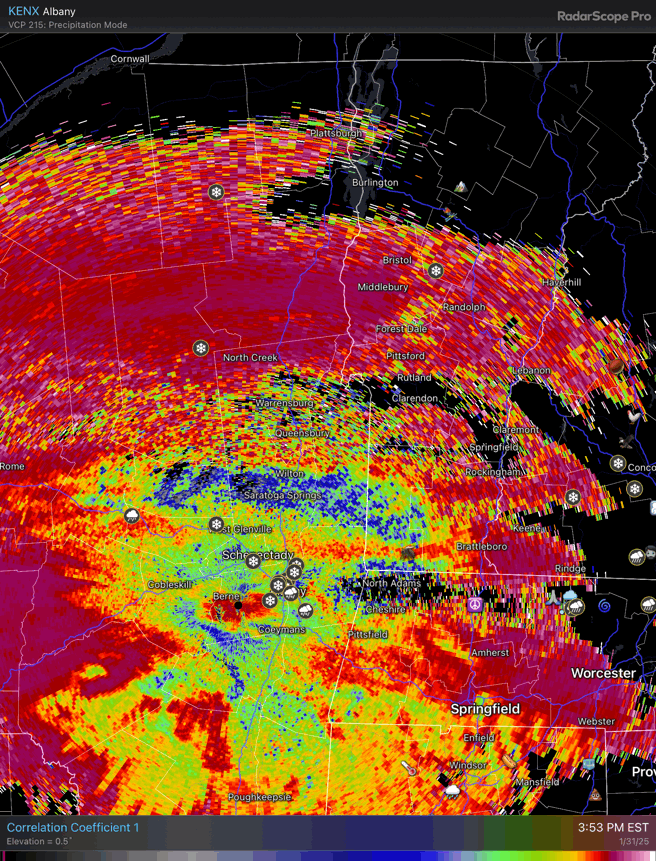
these maps and forecasts from okx and box are all over the place. if you didnt know any better or just like the general public you could get anything from 4-6", 4-7", 5-9" 8-12" for the same location! whether you click on the watch, the pc, the zone, or the 2 different maps they have. they gotta fix their messaging, its crazy.
And the watch for NYC/LI for 2-4 doesnt make sense
.thumb.jpg.273972c84ea1f814091afae425138bea.jpg)
I've noticed the same with GYX. These new maps they're using - while still having "storm specific" ones - are pretty confusing. The timeframe the represent and ranges make little sense to me, I am sure much less so to the general public.
-
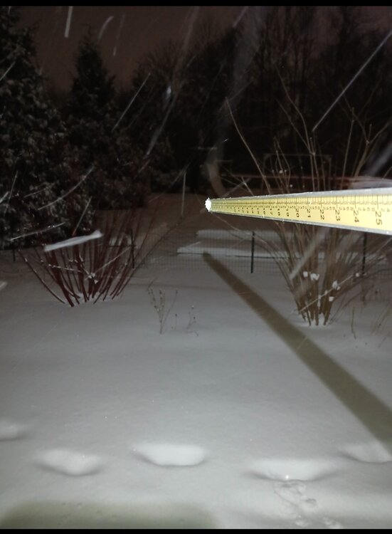
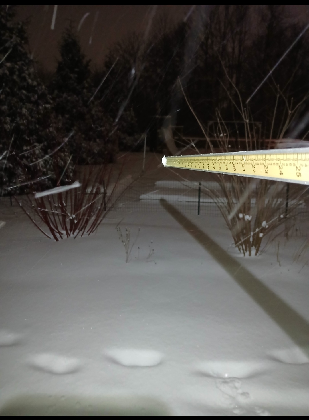
2.8"/0.25" LE/ depth 10" as of 18z PWM.
-
16 minutes ago, dryslot said:
Hopefully we start seeing these more amp solutions come back as we start to go thru the next several cycles over the next couple days or so, Models have weakened the primary in the ohio valley and then a weak secondary forms south of LI heading ENE over the atlantic.
What would cause the reversal? The trend has been for a weaker piece of energy over the OV, and is coming in flatter, too (I think)? Will a stronger primary be enough to amp it, or do we need the trough out west to speed up as well? Looked further east a few days ago, over CO, but now seems to be hanging back over the PAC NW. Not sure if that as an impact, too.
-
1 hour ago, SJonesWX said:
Last winter I had 57”, but it was a rat (average around 70”). I say rat because almost 20 of those 57” came after 3/23 which is too late for this guy. just a stat-padder. Also a rat because I got 4” in February, which is normally the snowiest month.
My favorite stat from up here (similar seasonal average) last winter was that I had more snow in April (8.0") than December, February, and March combined (7.0")
-
4 minutes ago, ineedsnow said:
GFS gone wild for Sunday
Juiced
-
 1
1
-
-
-
3 hours ago, powderfreak said:
You’re not the only one lol. The Stowe Family is always arguing with me that there’s more snow.
I think this is more common than we realize. Meaning, the public's perception of total snowfall compared to that of the observer (or even weenie).
This is my 4th winter doing obs for GYX. Friends around town will ask me how much we got, and each year, for almost every event, their response when I tell them the amount is the same: "that's it?"
People perceive a 4" event to be 6", or 10.5" to be 13". And that's in a place that, for the most part, see's less variability than your locale in term of amounts across a geographical area.
-
1
-
-
27 minutes ago, UnitedWx said:
You're in NH. I thought that was only a VT thing. Used to see tons of it along the snowmobile trails...
Yeah, that is an NNE-wide thing.
10 minutes ago, mreaves said:That’s why NNE is so much more picturesque in a snowy winter
Up to 38F and PC we drip and compact.
-
2.8" on 0.19" liquid will do it for PWM
10" depth as of 12z.
-
2
-
-
17 minutes ago, Prismshine Productions said:
I thought the rule of thumb was once an hour to see the rates
Sent from my SM-S156V using Tapatalk
I suppose you could check your hourly rate that way (assuming youre not wiping a board each time), but at least for the NWS climo site obs it's every 6 hours at 12/18/00/05z, or when it stops.
-
1
-
-
17 minutes ago, powderfreak said:
More like 1 trip outside every 6 minutes to make sure it’s still snowing. Or one could just look outside
 .
.
Guilty of looking outside every 6 minutes. Even when it's not snowing...you know, in case it does.
-
 1
1
-
-
5 minutes ago, Prismshine Productions said:
Sick as hell so going to minimize trips outside tonight
Sent from my SM-S156V using Tapatalk
You don't need more than 1 observation every 6 hours during precip.
-
1
-
-
23 minutes ago, dryslot said:
Looks like we may have some OES enhancement from the GOM heading due north.
.thumb.jpg.c160fe649713244a6804ed14ad438a29.jpg)
Been on and off flakes here for the past 90 minutes.
-
2
-
-
3.7" total on 0.31" LE. Ratios much better than expected.
-
3
-
-
47 minutes ago, OceanStWx said:
Nearly identical after midnight, but I had 3.1" before midnight.
That did put me over 10" for the month (exactly 12.0") though.
Nice! Suddenly we have winter (not climo but I will take it).
-
0.7" new 0.05" SWE new
3.3" total 0.30" SWE depth 8" in PWM.
-
4
-
-
9 minutes ago, dryslot said:
3”
Just now, tunafish said:SWE?
Curious your ratio. Pretty rare I hit 10:1 on the nose.
-
2.5" new 0.25" SWE
2.6" total for PWM
-
2
-
-
05z obs crew: assembllllllllllle
-
1
-
 4
4
-
-
3 hours ago, tunafish said:
I smell a bust incoming. GYX has PWM for 4-6" but we are right in line for that elongated dryslot.
So that 4-6" includes Sunday's event. Not sure what happened to these maps, now regional and 48 hours out covering 2 events? Strange.
-
I smell a bust incoming. GYX has PWM for 4-6" but we are right in line for that elongated dryslot.
-
1
-
-
3 minutes ago, dendrite said:
That was a quick flashover on CC.

Not even a shove south, just poof, gone.
-
4 minutes ago, Chrisrotary12 said:
I wonder what orographic features force squalls to always go to my north and south….
Let me know when you find out. Happens 9/10 times in PWM.
-
1
-
-
1 hour ago, dryslot said:
Folks up here got lulled into thinking this was over at 7:30 am, Its been SN to +SN over the last 2 hrs, The roads are horrendous.

Same exact story down here. Half the town is without power due to multiple accidents/poles taken out. Schools had a scheduled early release today, and they still sent the busses out at 7-8 even though plows hadn't been out.
.jpg.7b0e9b5d0f86a7759fb7ed13590ced02.jpg)

.jpg.8500108f03cb03a86c91b31a65ed9f73.jpg)

Tracking February 6. Light to moderate event potential
in New England
Posted
4.7"/0.55" - 12" depth
20.5°