

tunafish
-
Posts
1,683 -
Joined
-
Last visited
Content Type
Profiles
Blogs
Forums
American Weather
Media Demo
Store
Gallery
Posts posted by tunafish
-
-
16 minutes ago, tamarack said:
That's a lot of 'T' obs. I've only had 9, plus 17 with measurable snow. (Avg winter here has 25 'T's and 42 with 0.1"+.)
I'm at 15 obs with measurable, surprisingly close to your 17. Are those daily cocorahs obs, or another, more frequent increment?
-
Interesting / sad statistic I realized today:
I take the obs for PWM; new snowfall is called in every 6 hours.
This season, I have more Trace observations (22) than I do inches of snow (19"). The 19" represent 15 observations of measurable SN.
-
 1
1
-
-
14 minutes ago, dendrite said:
HRRR is really marginal down there. Watch out with the ptype intensity maps too because it will simulate very high reflectivities with wet snow/white rain. It’s painting 40dbz snow in spots with 34-36° 2m temps.
Noticed that over here with today's system. Good callout.
-
58 minutes ago, NW_of_GYX said:
Mesos were on crack for this one and everyone, including myself, bought into it. Nice little refresh but we’re gonna bust very low on GYX forecast. On to the next one
They nailed it for me, ha. Forecasted 0.7" and I'm going to end up at 0.8".
-
Initial batch of IP yielded a T @ 0700 and 0.1" shortly thereafter before switching to RN. SN/IP mix right now after 0.11" RN. CC seems to have washed out just to my South, so maybe we stay SN for a bit.
All the back and forth got me swapping out the 8" can like mad to try and not contaminate my frozen measurement. Already swapped 3 times since 7A Obs.
-
17 minutes ago, AstronomyEnjoyer said:
Sorry, used to to data analysis. I want all the data displayed, lol. I'll calm it down for you folks if that's preferred.
I appreciate the excitement and love for data - I am right there with you. The barrage of maps was a lot, is all.
13 minutes ago, RUNNAWAYICEBERG said:Where’s Wizzy?
See the banter thread, he posted about losing some loved ones this week.
-
 1
1
-
-
The spamming of clown maps the last 3 pages is sure something. Borderline unreadable in here.
Star boy... sometimes less is more.
-
3
-
 2
2
-
 5
5
-
-
1 hour ago, dryslot said:
12z HRRR is very bullish, I've had an eye on the models for Friday for a few days, They have been ticking colder and i made the comment in the other thread that i would probably see more snow Friday then the Sun-Mon event.
You're not kidding. I haven't been paying attention to it, but yeah, the 12z HRRR keeps even PWM snow through a majority of the event.
-
6 minutes ago, CoastalWx said:
Is Jay Peak looking to buy them out?

What, you're not buying their 200" season-to-date total?
-
3
-
-
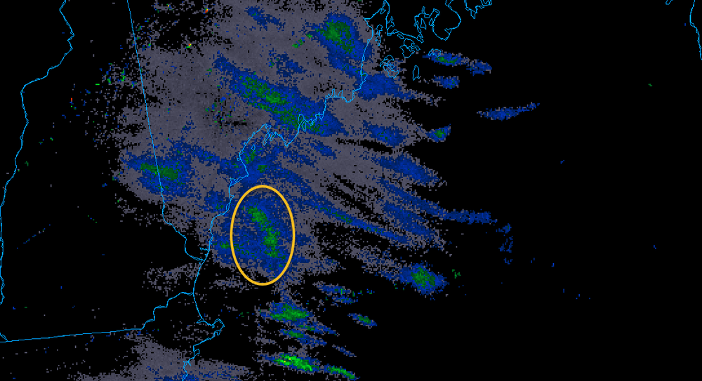
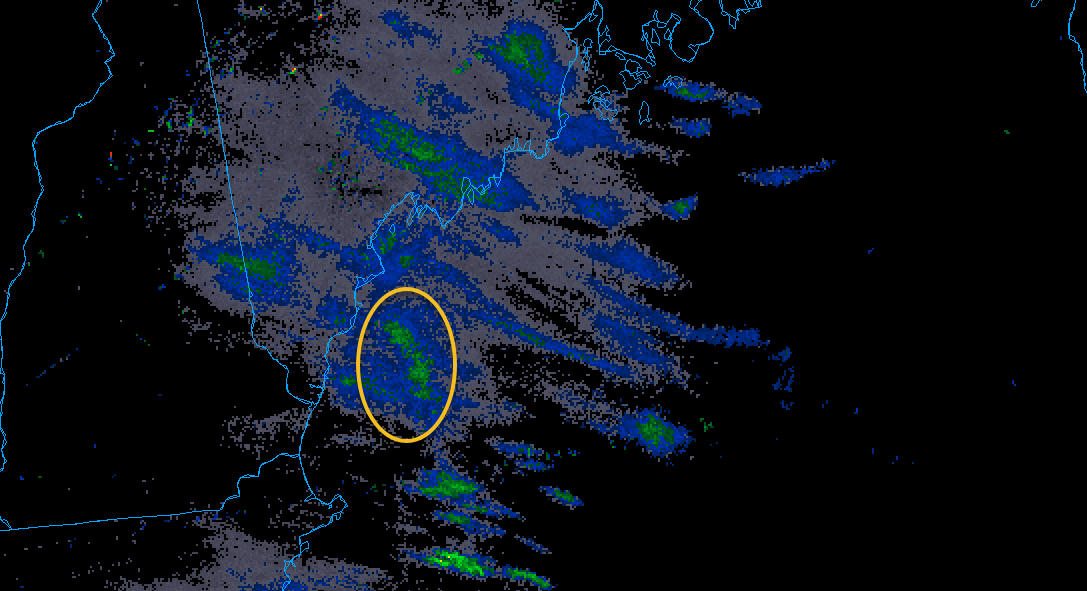
If you loop the radar, you can see the circled area of precip is moving north/northwest, against the grain of the rest of the precip.
Is this an inverted trough, or east winds kicking up, or something else?
-
-
3 minutes ago, TauntonBlizzard2013 said:
Why is it you disappeared for a week + while it was cold and snowy, only to crawl out of your hole on the first somewhat warm day in like a week and a half?
Seems disingenuous to be sure.
Because he's an insecure, humorless wanker?
36/11 PC
-
3
-
-
2.8" final SWE 0.35" - Portland, ME
-
1
-
-
Portland, ME obs:
Time - New Snow / Liquid / Depth
700 - Trace / T / T
1300 - 0.8" / 0.04" / 1"
Currently SN, 24/23
-
33 minutes ago, PWMan said:
I was getting impatient too, partly because my wife is at work and was asking me if I thought they should close the office early. This is a tricky borderline-type event in terms of amounts and timing; most schools are open, but at least a couple are doing early release.
We had early release which is probably the right call as road conditions will be much worse 230-3PM than they were 1230-1PM.
-
34 minutes ago, Lava Rock said:
I'm impatient with the wx, what can I say
You're consistent with calling for a bust early in events, I'll give you that much
")
-
1
-
2
-
-
8 minutes ago, Lava Rock said:
not sure about PYM proper, but 3-6" might be a stretch up near where we're at. still not sure how nws thinks mtns are getting 8-12"
I think we need to wait for the closed Low to get into the GOM for us to get ours.
Admittedly that's a total guess. But that's what I'm thinking.
-
1
-
-
2 minutes ago, Briz600 said:
Sorry! Location is in bio along with website don’t be lazy.
Location doesn't show your bio on mobile, and i don't use desktop.
One could argue not typing your location with your obs is lazy
-
Unless you're a daily poster....
post your location with your obs, ya n00bs.
-
4
-
 1
1
-
-
45 minutes ago, powderfreak said:
Nice hit there for you Mainers. Develops at the right time. Could be some good ratios
Hoping so!
Ratios are fickle at my spot just 3mi inland - and 3mi from PWM. Without checking my Cocorahs data, I'd guess my average ratio is between 7:1 and 8:1. At least for the the 6 years I've lived here, which includes 3 as PWM obs ('21-current).
I'd be interested what GYX has for climo ratio for PWM, and if ratios at my site are significantly different. Obviously my data only accounts for 3 years vs the 30 for climo, so not really a fair comparison yet, but I'm wondering if that lower ratio count persists over the next decade.
-
-
27 minutes ago, Torch Tiger said:
Almost there!!
Crazy part is there's a 4" perforated pipe in the middle. Just can't keep up. Haven't measured yet but might have broke 3" in 3 hours (8-11)
-
1
-
-
13 minutes ago, dendrite said:
Kidding aside, a good portion of their covered run is underwater right now simply because of the water table. I’m really hoping for a week long relatively dry stretch. We should freeze up decently this week so I’ll at least be able to throw some of my chopped hay/straw on top to keep their dry. But these cutters are becoming a struggle.
Mine too. They won't even come down from the coop. They hate this winter more than I do.
-
Just now, rimetree said:
2.3 and counting FFS
There's a (training?) line from PSM right up to PWM and it's just be sitting there for the past hour.


Monitoring the 29th/30th for significant impact coastal redevelopment - confidence only medium for now but is trending favorably.
in New England
Posted
Look I don't need a new fancy radar for my area. All I'm asking for is that the property owner adjacent to GYX cut down some effin' trees.
32.4 SN- and 0.5" new.