

tunafish
-
Posts
2,283 -
Joined
-
Last visited
Content Type
Profiles
Blogs
Forums
American Weather
Media Demo
Store
Gallery
Posts posted by tunafish
-
-
10 minutes ago, dendrite said:
Terrible.
1.28” for July here.
Yep, fugly.
Couple sites up in Lavaland are <0.50".
Sun breaking through now 67/64.
-
37 minutes ago, Lava Rock said:
0.16". Not expecting much today. Stein
Sent from my SM-S921U using Tapatalk
Same here. 0.77" MTD lol.
-
 1
1
-
 1
1
-
-
4 hours ago, JACKASS said:
On the subject of lobster, does anyone here actually go to Red Lobster?!
Everyone knows that an evening at Red Lobster is no small affair. I press my jeans, put on my finest hair product, and drench myself in a musky cologne. Hell, I may even shine up my wing tipped shoes, for I am going to Red Lobster. I strut through the door with my finest lady on my arm and throw up two fingers to the Hostess. I glide past the lobster tank with ease knowing that yet again I will not be eating a red lobster at Red Lobster (who would). I take a seat and before the waiter asks us for our drinks I request 20 cheddar bay biscuits. It's such a bold move that music stops, glasses clink, and everyone in a 5 yard radius gasps in disbelief/shock. Even my company gives me a look of concern. The waiter says " s..sir are you sure?". I don't sweat one bit and I tell that waiter to step and make with the cbb's. he comes back with three baskets filled with biscuits (7 in 2 and 6 in another). I thank the waiter. Then I go straight baller!!!! I'm pounding biszcuits left and right. Smashing them in old dudes faces, rubbing them between my ladies t*tties, telling the waiter to f*** off. I cause a ruckus, only get cbb's, don't pay a dime, and leave with my girl plus three more.That's generally what happens every time I go to Red Lobster, I've gotten banned from 33 locations. I tell you this to let you know that Cheddar Bay Biscuit shrimp sandwhiches are without a doubt the most ballerest thing a baller could ball at Red Lobster.
-
3
-
 4
4
-
 1
1
-
 1
1
-
-
1 hour ago, dendrite said:
Feels like another late summer night
Breezy and 63/53
The woods are getting that late summer nighttime sound. A low buzz that eventually builds into a cacophony another 30 days from now.
67/54
-
6
-
-
On 7/21/2026 at 7:37 AM, SJonesWX said:
i have a 6500 watt portable generator that I plug into an outlet outside the house which goes to a transfer switch. it is super easy, and powers everything I need, heat, water (on a well), and most importantly internet. i could use microwave but don't because it is obviously a huge power suck, and can't use the stove/oven.
On 7/20/2026 at 10:51 PM, wxsniss said:What's a good portable generator? Can it power multiple devices throughout house at once (fridge, lighting, HVAC, water heater)? If portable and only set up when needed, how can it be set up outdoors to power things inside? Asking not to be confrontational, I'm genuinely curious what the alternatives are.
We've lost power 5x this year, ranging from 3-16 hour times. Most times not even weather related.
My fear is having to struggle in pitch dark at 2am setting up a portable generator, and not able to ensure kids can sleep and we have refrigeration / hot water.
This is more or less what I have. It will run the roons and basics of the house, including continuous appliances (heat pumps, water heater, 2 fridges). You can run one temporary big appliance on top of that, like a dryer or microwave, just not multiple.
Have lost power in the middle of the night in winter and didn't even think about rushing to set it up in the dark and weather. Keep the fridge shut, and get the generator going in the daylight.
You shouldn't (can't?) run them in the rain, so if you go this route, given how often you lose power I'd recommend building a little housing unit for it. Keep it dry and in place for when you need it. I think @dryslot built himself a nifty little shack iirc.
-
1
-
2
-
-
7 minutes ago, dendrite said:
Got muggy overnight. Some rain would be nice.
I'm at 0.53" for the month, including yesterday's 0.20.
Would like some rain, but June was AN so can't complain too much.
-
2
-
-
"These stupid board settings won't let posters upload full pictures and the admins are too cheap to fix it!"
Several posters proceed to upload a multitude of full-sized pictures.
Too perfect.
-
4
-
-
19 hours ago, Winter Wizard said:
I think it's pretty clear that the wildfire smoke was the main culprit for thunderstorm activity not occurring over Maine as it suppressed instability to an extent and created and maintained a mid-level cap. Doesn't seem like modeling picked up on that at all. On the opposite end of the spectrum, the lack of storms in Maine also meant that the environment S and W was untapped and contributed to overperformance farther south in NY, VT, and NH. The forcing was clearly there and this was close to being a much more destructive event. I think we got pretty lucky all things considered but numerous severe reports in this region doesn't constitute a total "bust" IMO.
The local mets here were saying that when the front passed by the Ontario fires it caused them to flare up a ton - and modeling hadn't considered that.
About 4 minutes in https://youtu.be/K5Y3sW9b4Gs?is=6dEwOaDH-42u7ttl
-
1
-
-
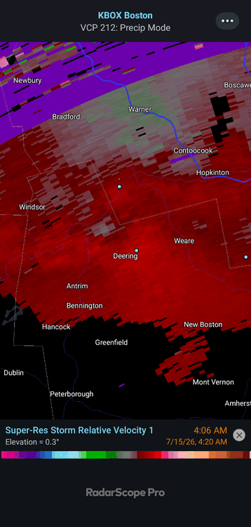
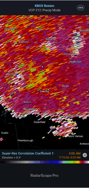
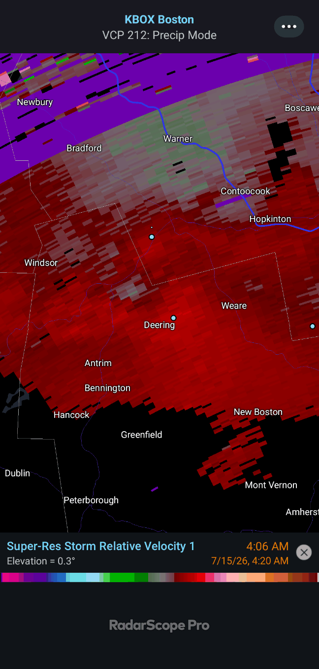
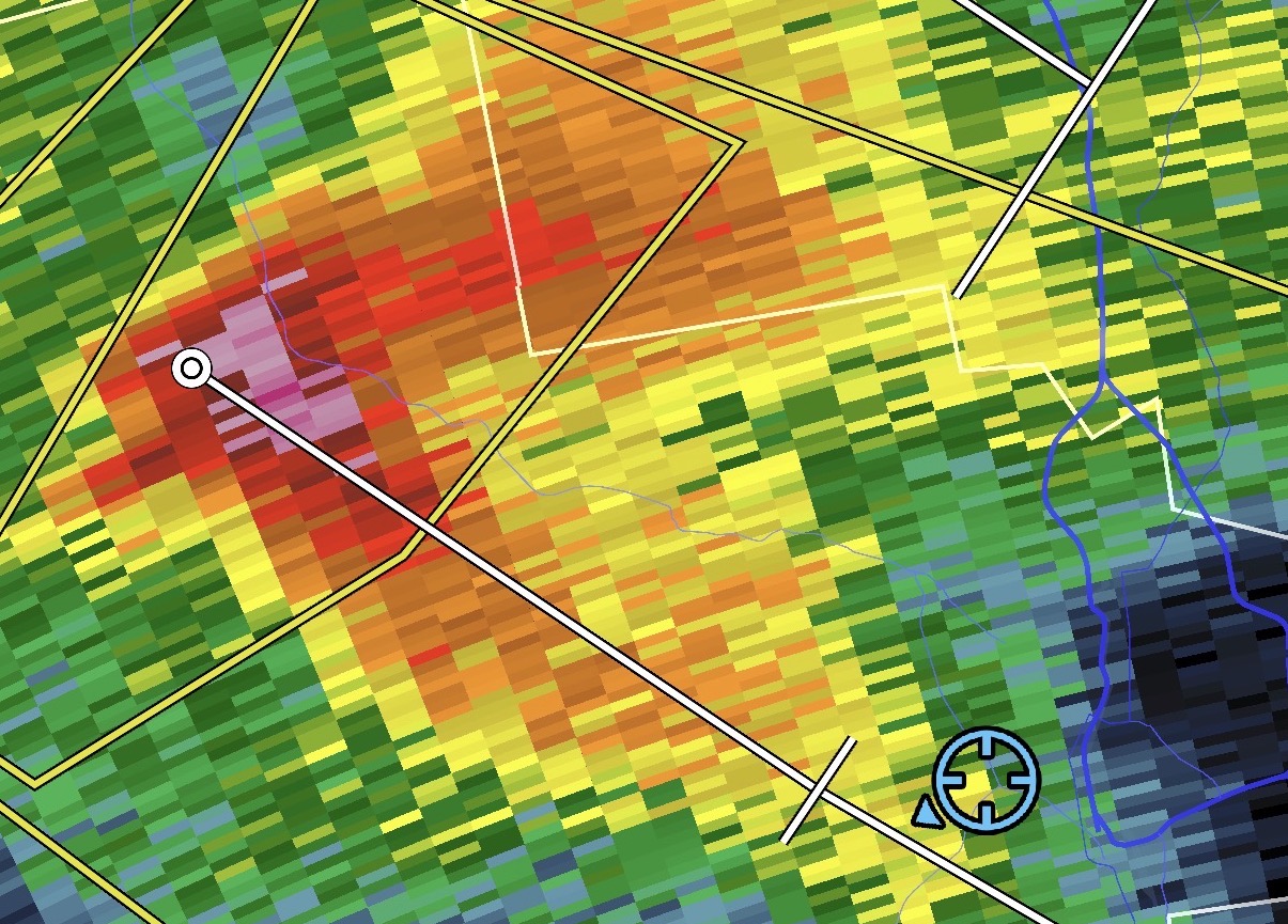
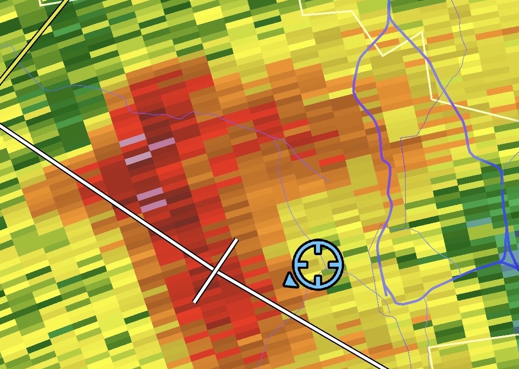
13 hours ago, vortex95 said:
Quite the tree damage I am told Springfield VT to Claremont NH. I-91 was closed for a time. Saw this report:
"You can see the path just south of mile 48. I-91 is a debris field for a quarter mile. Twisted trees snapped off that were more than a foot in diameter."I wondered about a potential spin-up, especially after looking at CC. Admittedly I am not a pro, though
Families location is the dot above Deering.
.thumb.gif.4f723c25406a1dd2ee3e901dbf08a6bc.gif)
-
1
-
-
2 minutes ago, dendrite said:
Wth is going on with satellite
Safe mode'd.
Update (7/15/2026 7:18:26 PM): On Wednesday, July 15, 2026 at 20:23Z/GMT, a GOES-19 / GOES-EAST satellite anomaly occurred which sent the satellite into "safe" mode. Recovery is underway, but it may take days or longer for imagery to resume production. Until then, no GOES-EAST imagery of the US or the Atlantic will be available. We apologize for the inconvenience. ---Nexlab Staff
-
1
-
-
11 hours ago, JJBASHB said:


Heard from my in-laws in Deering there's a ton of down trees on lines up on their hill from that line at 4AM. Awaiting pics.
-
2
-
-
2 minutes ago, dendrite said:
Doubt NY but if 1 state wanted to buck the rest of the region it would be NH
Wouldn't be a hard sell to get Maine on-board.
-
13 hours ago, Damage In Tolland said:
Can we all please get this in our yards ?
https://x.com/maxvelocitywx/status/2074336458748416424?s=46&t=dhcbvkjmRcyBVQtDxJ3lRg
Ah yes. Enough wind to topple trees but not even budge the patio furniture.
Dummy.
-
2
-
-
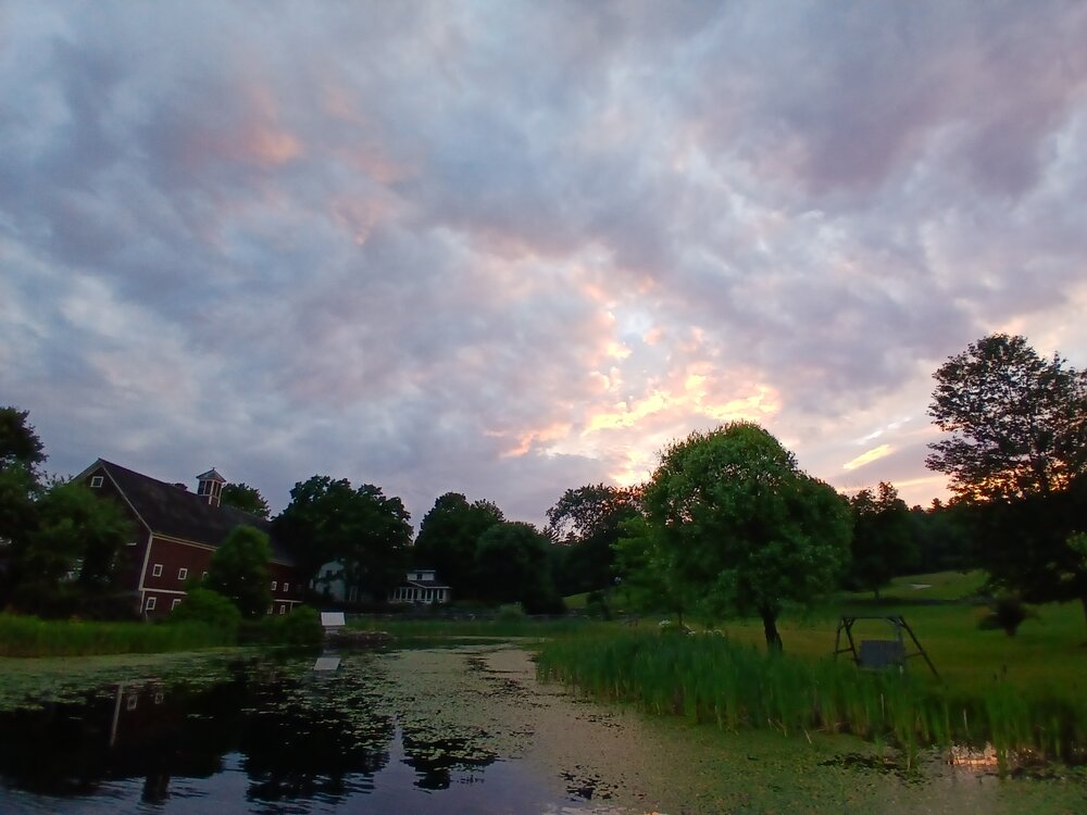
Dodging drops in Henniker (NH) at sunset.
-
2
-
-
1 minute ago, vortex95 said:
Classic vague tease. "Get ready" For what? Makes one click! And the arrow points to northern Mexico? And it is totally unclear what the color shading is depicting, but as long as it is bright and flashy, who cares!
I was about to give you a hard time for being so triggered over these clowns, but then here I am ready to Will Smith the next person I hear say "heat lightning".
-
14 minutes ago, Lava Rock said:
with AC on inside?
He seems like the guy who counts driving his truck and walking inside from a parking lot as "working outside".
-
4
-
1
-
-
Didn't expect anything to pop off this far east without warning. Must be the outflow from Sebago hitting thr marine air.
Lightning scared the shit out of me while I was taking an outdoor shower.

-
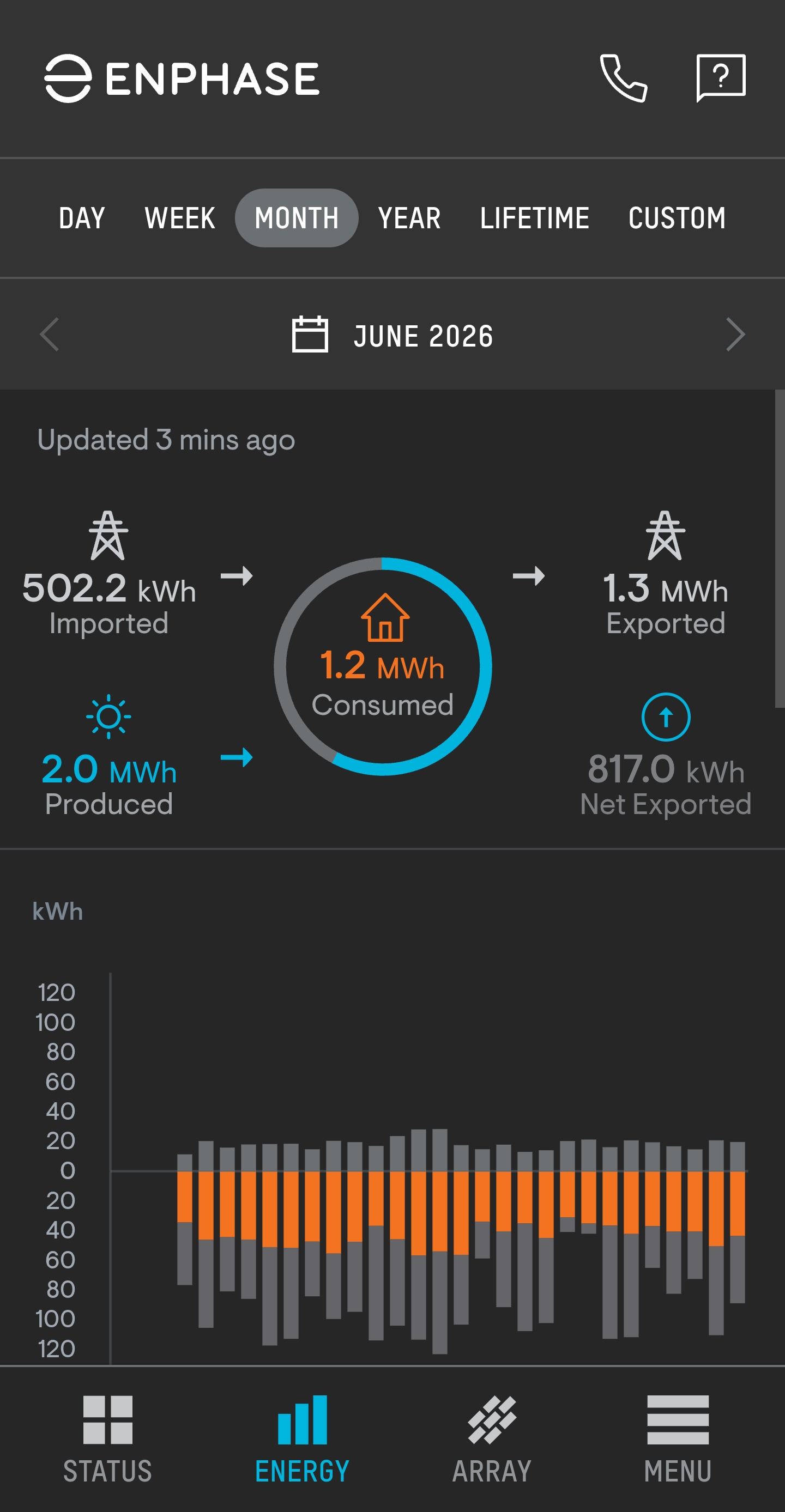
5 hours ago, Ginx snewx said:
Ours only online since June 4th
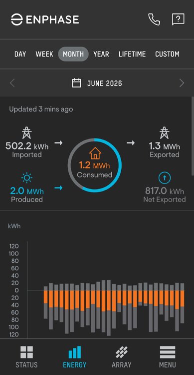
Great production. It took me like 28 days of bluebird August 2025 to hit 2MWh in a month. How much does the pool filter add to your consumption?
-
Severe storm moving through Augusta 50 miles away from Scarborough beach.
.thumb.jpg.c4a598100bcba70e87a2f08ce5d79a4c.jpg)
-
3
-
-
Good cloud action before sunset. Towers from storms about 35 miles west of PWM, with some fog bank rolling in.
.thumb.jpg.952ad60f4a936fc6e377d40bf4a59fb8.jpg)
-
6
-
-
-
2 hours ago, Lava Rock said:
Damn. After last night's rain, we're only at 4".
2.52" yesterday
5.18" MTD
16.30" since 4/1
-
3
-
-
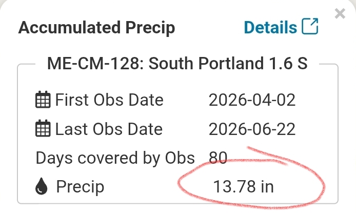
3 hours ago, dendrite said:
12.37” here
Well, if we're having a rain stick measuring contest, I'll whip mine out.
-
2
-
-
Lol wtf happened
1.93" overnight
-
 1
1
-
 1
1
-
.gif.15ebd334109e52faae6f4f6beec282f3.gif)

.jpg.3f6f02df1fbea90af81824d597c8e1d1.jpg)
.jpg.c0c13a148c0b78f6925fdec13d8a3ab4.jpg)

Lawn Thread Gone Wild 2026
in New England
Posted
Wow, that's wild.