

Paleocene
-
Posts
1,497 -
Joined
-
Last visited
Content Type
Profiles
Blogs
Forums
American Weather
Media Demo
Store
Gallery
Posts posted by Paleocene
-
-
Just now, WxUSAF said:
This has heartbreak written all over it for some of us in the subforum. But a long way to go, so hope I’m wrong. Good thing most of us will score tomorrow.
On the other hand, non zero chance of back to back (to back? Getting greedy) warning level events. Pretty cool! But agreed on fail risk
-
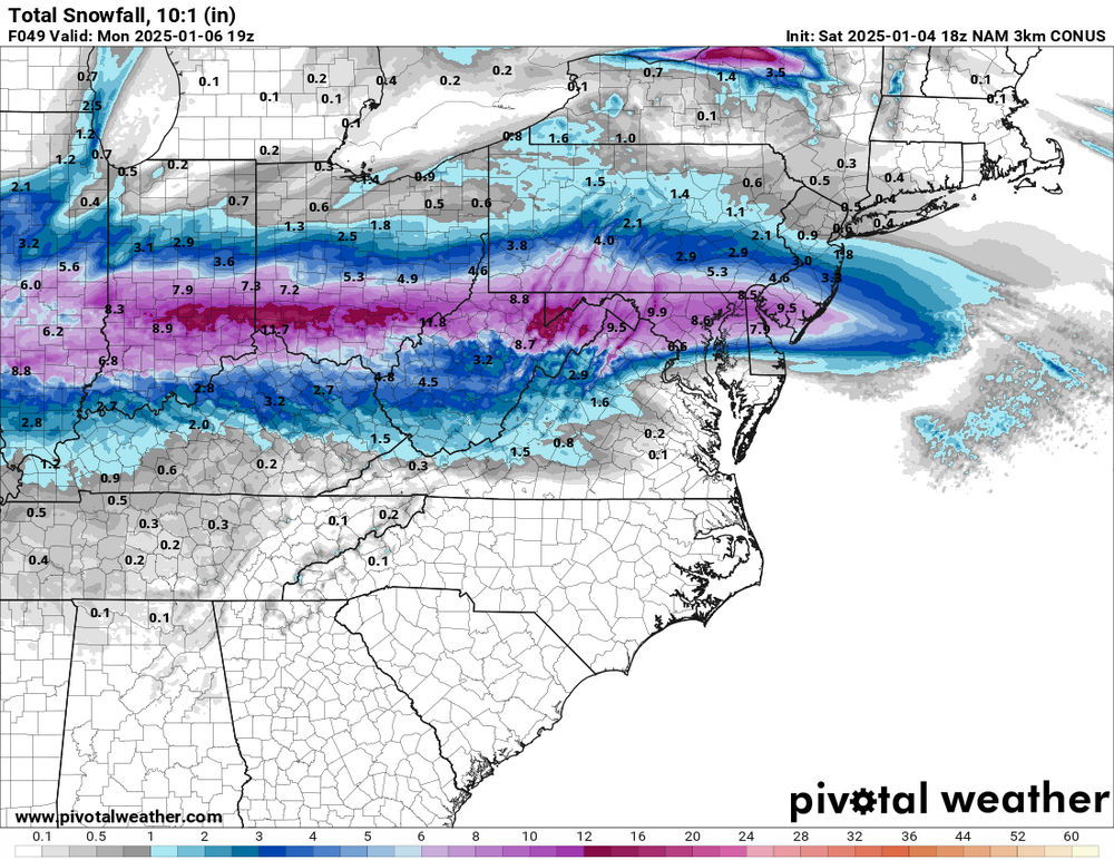
That's a decent slug of sleet on the 3k NAM from roughly MD 200 / MD 32 south.
IDGAF I'll take the glacier.
-
 2
2
-
-
1 minute ago, DDweatherman said:
The 3k is a thing of beauty for a lot of folks in here. Will make many friends. Someone post a map.
Thru 49 hours. Possibly some wraparound to come later after a dry period.
-
2
-
 1
1
-
-
28 minutes ago, yoda said:
https://www.wpc.ncep.noaa.gov/discussions/hpcdiscussions.php?disc=qpfhsd
Afternoon winter disco from 237pm
"As this surface low deepens and move east, impressive moisture will be drawn northward from the Gulf of Mexico within a corridor of intensifying isentropic ascent, especially within the 290-295K surfaces. Here, mixing ratios climb to 4-6 g/kg, reflective of the impressive moist driven by the warm advection, further evidenced by PW anomalies surging to above the 97th percentile according to NAEFS."
 we're pulling that good gulf juice into this baby. Visible on those nam charts ravens is pulling
-
5
-
 1
1
-
-
First law of 12k NAM: if it's showing a lot of snow, believe in the power of being NAM'd
Second law of 12k NAM: if it's showing not enough snow, it's dead wrong and a booty cheeks model
-
 2
2
-
-
3 minutes ago, CAPE said:
18z GEFS looks pretty solid. Similar to 12z but just a tad drier. Mixing is a thing on a significant number of members for the lowlands.
What's your definition of lowlands. How far from the fall line?
-
Puking thicc fatties with a stiff breeze in the 20910. Sick
-
Some preliminary mangled flakes coming down in Silver Spring now. Cloud cover got way thicker since 2pm, when the sun was breaking through in spots still. Squall line looks to be headed through fairfax soon.
-
12 minutes ago, jpljr77 said:
Capital Weather Gang's first map is up: https://www.washingtonpost.com/weather/2025/01/03/dc-region-snow-winter-storm-forecast-ice/?itid=lk_fullstory
This looks like a reasonable call at this stage. And it's nice to finally have a map where it's a solid stripe region wide, without gradations running SW-->NE, where the mountains/piedmont get snow, and we in the metro corridor/fall line and lowlands get mix. Reminds me of the January storms last winter.
-
Sun's out in Silver Spring
-
1 minute ago, IronTy said:
Damn that Kuchera euro...is this shit really gonna happen? I'm skeptical.
Inside the DC beltway and Southern Maryland getting 8+ inches? Would be super cool. But I'll believe that once we see runs of that for the next 48 hours straight lol.
-
Good God the willingness to cliff jump over the icon...
-
This is slightly off topic and a question for red taggers. But what are the statistical error ranges on projected snowfall or qpf totals? Are there any comprehensible stats that describe that somewhere? I'm wondering when I hear people mention things like "oh I lost .2 qpf on the latest run." What's the error range on .75 expected qpf at 120 hours out? Probability bounds? Confidence intervals?
-
Just now, wxmvpete said:
I don't get enough practice posting in here to see what is too much haha. I'll try to shorten my posts more!
Don't shorten the posts! Many of us are eager to learn more.
-
9
-
 1
1
-
-
time to bring this back up to remind people to post here instead of the LR thread. GFS 18z run for monday was booty cheeks for i-70 corridor and north.
i'll take my 2-3 inches that won't accumulate on hot urban corridor roads!
-
1 minute ago, stormtracker said:
The south's HECS is gone. H5 is just sloppy. Storm gets shunted S and E. 12z was MUCH better at H5. Oh well...only 500 more runs until the event. See yinz at 0z!
You mean it's not going to snow 24" in Augusta, GA?
-
1
-
1
-
-
3 minutes ago, stormtracker said:
All these players on the field, regardless if there's no storm, is kinda exciting. You gotta thing somethings gonna go boom in future runs
That GFS run is also cold as heck next week after our snow. Snow should stick around.

-
5
-
-
NAMd


-
3
-
-
Goal: flakes that stick
-
2
-
-
Just now, TSSN+ said:
Baby steps.
Moving towards euro/UK
-
As we have seen with past storms The exact position of the stripe is never modeled accurately until 24 hours or less. Even that it's not always right, sometimes off by 50 plus miles. Euro looks great and I wouldn't sweat it DC and points north
-
1
-
-
What was the DC beltways largest accumulation since the 2016 blizzard? I'd die for a foot plus
-
That gfs run looked pretty good to me.
-
1
-
-
59 minutes ago, 87storms said:
Yes, and so can a nw, downsloping breeze.Nice. I live between two creek valleys on a hill, so I'll accumulate wind chill with no trouble


January Banter 2025
in Mid Atlantic
Posted
@Jebmanputting this in banter where it belongs but here inside the DC beltway i am PRIMED to get out my snow shovels out of the garage this morning. Am i putting out any salt to pre melt on my driveway or sidewalk? NO! I am going to SHOVEL this HEAVY SNOW. I am going to PUT THE CAR ON THE STREET so it's not safe in the garage specifically so I CAN DIG IT OUT!
Also, the guy who we bought our house from left a bunch of outdoor equipment here, including two shovels to supplement the two I already owned. I AM GOING TO DUAL WIELD SHOVELS