Newman
-
Posts
2,500 -
Joined
-
Last visited
Content Type
Profiles
Blogs
Forums
American Weather
Media Demo
Store
Gallery
Everything posted by Newman
-
0z FV3 GFS is absolutely insane
-
GFS is just a huge crusher
-
Entire state of Jersey is 18-36" on thar run, unreal!
-
18z NAM already looking much more amped
-
I know the High End snow maps can seem like weenie bait, but as an EM met they are crucial for communicating POTENTIAL impacts. In EM, we always prepare for or are staged to respond to the worst case scenario. You never want to be caught with your fly down
-
Mount Holly 90th percentile (i.e. reasonable worst case scenario)
.thumb.png.e54f5ea6bbea24f0f741077b31db97c5.png)
-
Maybe a bit bold, but I told my family in Berks and Lehigh to expect 5-8" right now. I think 3-5" is safe, but I'm thinking there could be an outer fringe 700mb fronto band that surprises. Dual band type of precip shield. Would feel even more comfortable if I was NW of 95 if the closed 700 mb low passage was tucked closer to the coast. My fear is this tries to slip east last second just based on past PTSD lol
-
Ukie with a massive shift west, gets 6-8" to Philly, 12-16" locally along the Jersey coast. 2-5" back to the Lehigh Valley
-
GEFS gonna be unchanged mostly for Philly SE, but the orientation of the more SW to NE precip shield is being reflected across the Lehigh Valley where the gradient is tighter. Probably just noise, I guess we'll see. MSLP low placements actually ticked west quite a bit on the GEFS at 12z. And I'm referring to MEAN Total QPF, so honestly there may have just been a rogue member that rained to I-95 that got removed this run
-
GFS is gonna score it's biggest coup ever here. I mean I just don't see how it doesn't at this point. 12z GFS: The trough is actually more amplified so the storm initially develops a touch further south. It tucks, but the occlusion process takes it a smidge further east this run which is why parts of the Lehigh Valley get lower totals overall (still 8-12"). The initial jet enhanced precip is also less expansive and has been trending less on the GFS, which also keeps totals lower further NW. Nitpicking here though, mostly just noise. Whichever areas get the most snow is dependent on the very fine scale phasing that occurs that we won't know for another day.
-
Ha sorry, busy at work Double tasking PA and FL weather today
-
Just a reminder that each subforum will be looking for different trends with this one. Mid-Atlantic is looking for a quicker tilt negative/stacking of the low vs NYC or New England that want a later tilt and later maturation of the low. Our subforum I think is probably in the best spot
-
12z ICON tuck right off of Delmarva. Delaware and Jersey getting shellacked at hr66
-
NAM shatters Delaware's all-time state snowfall records by ALOT lol. Unreal run for them, winds gusting to 40-50 mph as well.
-
The GFS feels like that very far western ensemble member that keeps giving you hope. Except this time, it hasn't budged while the eastern envelope has shifted closer towards it. We're narrowing the goal posts: the western post staying put and the eastern post shifting west. Usually we see a 50/50 compromise, maybe 40/60. This time maybe 25/75 or 20/80. It's just been unusual this go around seeing models move towards the GFS. Again, Delaware and coastal Jersey seem to be the place to be right now
-
The NAM tucks the low but closes it off/occludes it much further south along the Virginia coast. Probably just NAM doing NAM things
-
GEFS bump NW as expected
-
That's an all-timer run for Philly and SE Jersey
-
I can assure you there would be banding well to the NW of where the GFS is showing
-
CCB right on top of Philly omg!
-
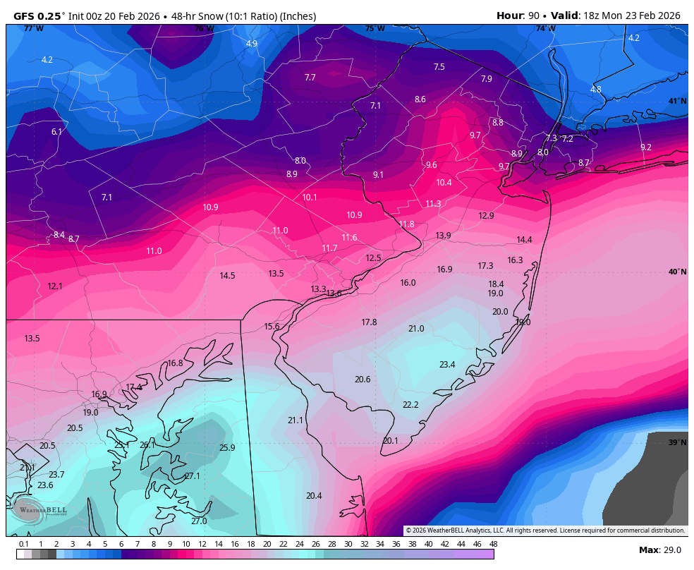
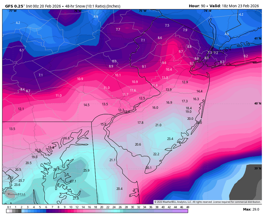
6z GFS not backing down, this is really incredible. Money shot for Philly
.thumb.png.8ba80ab6730767e6774992f5b0e994c8.png)
-
For fun
-
GFS actually shifted a bit SE with the heaviest totals with the storm occluding further south. So it moves ENE off the coast and then the precip shield pivots NW into New England. There most certainly would be a few heavy bands further to the NW than what the GFS is showing though. In the end though, noise changes. Steady and no signs of a GFS cave yet


.png.44497121c75879bd8dff3948113cdeaf.png)


.png.02d91962523a24d7e604cafde1a5e25b.png)