MAG5035
-
Posts
6,078 -
Joined
-
Last visited
Content Type
Profiles
Blogs
Forums
American Weather
Media Demo
Store
Gallery
Everything posted by MAG5035
-
Central PA - Winter 2020/2021 Part 2
MAG5035 replied to MAG5035's topic in Upstate New York/Pennsylvania
Yea lol, everyone all worried about stuff getting suppressed this week. Look at where tonight's swath of snow is going. Plus, should throw out the friendly reminder of where guidance had yesterday's storm during that 72-84hrs lead time.

-
Central PA - Winter 2020/2021 Part 2
MAG5035 replied to MAG5035's topic in Upstate New York/Pennsylvania
This week really hasn't been about getting the big storm, but chances at more moderate snow events. We're running a pattern on a gradient between alot of arctic air and some attempted eastern ridging.. pretty much a zonal pattern alignment. We don't have the amplification for a big storm (yet), but we have an active storm track with multiple waves tracking the gradient. I made a more detailed post about this last night at the top of the previous page. -
Central PA - Winter 2020/2021 Part 2
MAG5035 replied to MAG5035's topic in Upstate New York/Pennsylvania
I'm not too concerned about suppression currently. It's become apparent that the storm track this upcoming week is going to keep us near or in the crosshairs of several waves rather than a complete overwhelming of arctic air via dumping the PV into the east. We have an eastern ridge trying to pop up against this blocking pattern and hyper negative NAO/AO...elongating the PV and providing this gradient pattern with alot of cold air availability. Could be the MJO trying to influence some as it has and will continue to be mired in Phase 6 and now 7. Usually those phases strongly correlate to eastern ridging JFM (especially 6 but 7 reflects it too). Other than the PNA starting fairly negative, MJO is really the only teleconnection flying in the face of the majority of them being pretty supportive this week (-EPO/-WPO). We have such an established blocking pattern up top that instead of what could have been a period of warm weather, we instead have a battleground for delivering potentially more decent snow events. The exchange in all that appears to be not having straight up frigid weather. So god forbid it might not be -15 to -20ºF lol, but we're going to have multiple chances for wintry weather. Just have to nail down the swaths, and it's probably going to vary favoring different parts of the region and perhaps introducing p-type issues in some instances. I would be surprised if that PV doesn't directly get swung through at some point within the next couple weeks though. I feel like when this overall pattern does start to break down/change/etc (and it will eventually) that all this cold that has gotten to our side of the pole is going to get moved around. And typically, such a thing likes to happen on the heels of a major amplification and storm system. -
Central PA - Winter 2020/2021 Part 2
MAG5035 replied to MAG5035's topic in Upstate New York/Pennsylvania
Tuesday's potential light event seems like it may target central and/or northern PA more than the southern tier by the looks of most of this afternoon's guidance. That's looking like a 1-3" stripe of snow wherever it decides to throw down. Good to see the Euro backing down on bringing the ice into PA with that Thurs/Fri event for now. Seems like it could be a couple different surges of precip with that and a bit of an extended WAA precip phase before the eventual low comes up toward PA. Doesn't look like something that would deliver excessive snows but could be a real nice snowpack builder (moderate with a stripe of heavier totals). I"m not going to rule out potential mixing issues in parts of the region with this eventual system but the setup should favor mainly frozen. Lot's of cold available and an established snowpack lends some support to the PA favorable storm track. And we're not winding up a big storm with this so any WAA surge aloft would likely be limited. -
Central PA - Winter 2020/2021 Part 2
MAG5035 replied to MAG5035's topic in Upstate New York/Pennsylvania
About a half inch fell early this morning, as expected petty much so no complaints. -
Central PA - Winter 2020/2021 Part 2
MAG5035 replied to MAG5035's topic in Upstate New York/Pennsylvania
Woke up to a dusting and some steady snow indeed falling around these parts this morning. 24°F -
Central PA - Winter 2020/2021 Part 2
MAG5035 replied to MAG5035's topic in Upstate New York/Pennsylvania
Here was the CTP update a couple hours ago. Def more leery of the NAM's optimism by the sounds of it. HRRR has looked like garbage in terms of any decent snows, with the latest full run (03z) not even having advisory snows in CTP or pretty much the northern half of LWX's CWA... where there's warnings up. I think HRRR is underestimating precip shield.. it definitely did during the latter stages of last weeks winter storm with the roving bands of snow. How much so is debatable. DC's problem with the lack of accums being presented is the HRRR has half the event as rain. LSV shouldn't have to worry about that. Speaking of temps.. sure wish I had direct incoming with the nice crisp 21ºF and overcast conditions here currently. -
Central PA - Winter 2020/2021 Part 2
MAG5035 replied to MAG5035's topic in Upstate New York/Pennsylvania
Possibly some kind of a light event Tuesday, with some light snow streaking across PA (perhaps light mix southern tier depending on the model). It seems the bigger trouble brewing will be late week in the Thur/Fri timeframe. This is looking like a drawn out warm advection type event at first with an eventual wave(s) of low pressure coming up towards PA. My concern with this setup is given the gradient pattern and the arctic air nearby is it looks like quite a favorable setup for having a significant icing swath. Not necessarily here, but somewhere. 18z GFS for instance mainly snow with this while the afternoon Euro run had alot of ice into PA. Those details are impossible to nail down at this point, but that Thur-Fri timeframe looks to be where the next more significant precip event materializes. Also the question of cold air, as the big time arctic air is on the playing field but trying to figure out how much eventually releases into the eastern US. Models have literally been all over the temperature spectrum, from the mixing events and temps near somewhat above freezing at times to throwing the whole polar vortex over the Great Lakes/NE and what would likely be record cold. Still going to be pretty cold immediately behind tomorrow's system but the significant arctic cold that was looking to happen earlier this coming week now looks to hold off to perhaps D6-7 or so. Guidance is having alot of trouble handling location of the gradient/storm track and the longwave pattern in general. -
Central PA - Winter 2020/2021 Part 2
MAG5035 replied to MAG5035's topic in Upstate New York/Pennsylvania
Lol, you guys have been reading the Mid-Atlantic thread haven't you? I know this isn't looking as great as it was but it still should be a general advisory type event for the LSV. The NAM and company had been the guidance in particular leading the way with that widespread 6"+ and we should all know the NAM can giveth.. but it most certainly can taketh away. Most other guidance has generally been less of a widespread 6"+ threat and more of a debate of how expansive the precip extent is going to be. I thought the coastal low had a chance to run up right on the coastline but it's looking like it will track offshore some, pulling the axis of best snowfall associated with that back southeast some. Basically back to my original SE of I-81 thinking with the best accums. Jury still somewhat out on that NW extent of the precip shield between blossoming coastal and also the area of precip back out over MO/IL/etc. I like a general T-2" NW of I-81 covering back to the I-99 (AOO,UNV,IPT) corridor and perhaps even western PA as we certainly can't rule out a period of mostly light snow anywhere in those areas. Obviously the best chance of 2" or perhaps a bit more is closer to I-81 or perhaps some southern Laurels locations. 2-3" (advisory event) for places like MDT and more of a 3-5" York/Lancaster with an outside chance at some scattered higher amounts near the MD border.. but mostly this is looking to top out at 4-5" by the looks of it. -
Central PA - Winter 2020/2021 Part 2
MAG5035 replied to MAG5035's topic in Upstate New York/Pennsylvania
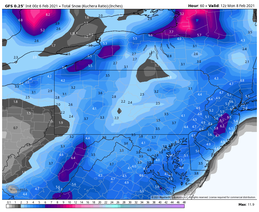
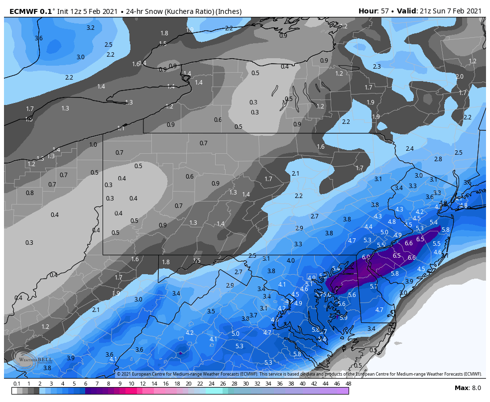
Here was last night's 0z HREF 24hr snowfall, which is short range ensemble guidance that NWS factors pretty heavily into their snow maps, and you can see why CTP opted for watches in Adams, York, Lancaster. Thought this was the 12z run but good thing I double checked bc it hasn't run 12z yet on the SPC site. Would imagine whatever the 12z shows will factor into whether they opt for warnings in the watch area. Considering the full suite of guidance, they're pretty locked down on the general location of the best swath of snow but there does still seem to be quite a divide in guidance though when it comes to amounts of said swath . Looking at the 12z GFS and GEFS, it's barely an advisory event in the watch counties and a general 1-2 in the rest of the Sus Valley, RGEM same way although that particular model has generally been SE the whole time on the lead up. 06z Euro/EPS supports Sus Valley wide advisory event but borderline at best on upgrading the watches to warnings. It's the short range guidance like the NAM/SREF/HREF that have been robust on warning totals and the 09z SREFs are most robust on NW extent with solid advisory amounts all the way back past I-99. So all things considered, I think what CTP currently has out snow-map wise is pretty good representation right now with location of the swath of best snows and perhaps tempered expectations on the top end accumulation wise.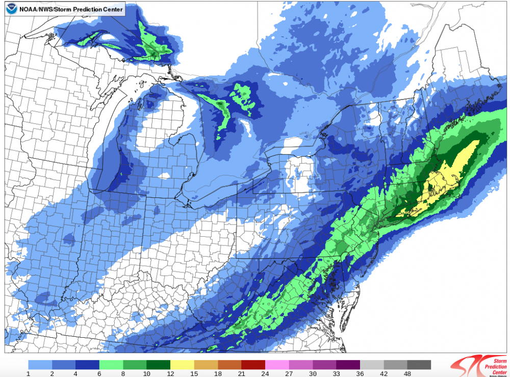
-
Central PA - Winter 2020/2021 Part 2
MAG5035 replied to MAG5035's topic in Upstate New York/Pennsylvania
0z GFS again with the broad coverage but not much in the way of 6"+.
-
Central PA - Winter 2020/2021 Part 2
MAG5035 replied to MAG5035's topic in Upstate New York/Pennsylvania
I said earlier I'd consider it a win if I saw 1-2" back this way and that it just had to suck me back in haha. I'm thinking the central counties' (NW of I-81) chance at seeing anything notable hinges on any interaction between the two shortwaves that can generate an area of snowfall further back.. something to the tune of what the 18z GFS tried to do. -
Central PA - Winter 2020/2021 Part 2
MAG5035 replied to MAG5035's topic in Upstate New York/Pennsylvania
Thermal gradient could argue for that closer surface low track ala the NAM.. which has the low into the southern Delmarva vs the GFS/EURO staying notably off the coast. Not like we're stuffing this system down with a significant arctic air intrusion that can push the baroclinic zone offshore. (actual cold air comes in behind this sytem). DC's coming off a day where it's 50ish tomorrow and temps during the event aren't overly cold even in the LSV. Ugh, this system just had to suck me back in lol. -
Central PA - Winter 2020/2021 Part 2
MAG5035 replied to MAG5035's topic in Upstate New York/Pennsylvania
Measured 0.5" of new snow at daybreak, which easily melted off non-snow surfaces this morning. Just did some measuring to get the state of the snowpack in the yard. Mostly ranges 6-9" with an area of shallow snow <3" on the one corner and an area of 14-17" on the downwind side of the house and between the house and the shed. Before the snowpack softened yesterday, that last 3.5" Tuesday evening was windblown and the wind continued Wednesday with some significant blowing and drifting. -
Central PA - Winter 2020/2021 Part 2
MAG5035 replied to MAG5035's topic in Upstate New York/Pennsylvania
The Euro's take: Not focused like the NAM with the big amounts but a broader precip shield. Euro and esp GFS illustrate what I was suggesting in last night's post with getting the northern and southern shortwaves close enough to interact and cause a more expansive shield back NW of I-81. Wouldn't be heavy but I'd consider 1-2" a win back this way if it happened. This is starting to look like an advisory type event roughly I-81 east and I-78 south.
-
Central PA - Winter 2020/2021 Part 2
MAG5035 replied to MAG5035's topic in Upstate New York/Pennsylvania
Heavy snow, roads caved already. -
Central PA - Winter 2020/2021 Part 2
MAG5035 replied to MAG5035's topic in Upstate New York/Pennsylvania
Snow has arrived here, on a ripping southerly wind. -
Central PA - Winter 2020/2021 Part 2
MAG5035 replied to MAG5035's topic in Upstate New York/Pennsylvania
My take on this Sat night/Sunday system is the most likely area for accumulating snow in C-PA is probably going to run I-81 and esp SE of I-81 (could be an I-95 axis). This storm could sneak back a bit more but I don't see alot of amplification (much more progressive than our last system lol) and the northern and southern shortwaves stay separate. I think the best chance NW of I-81 is if there's a bit of interaction and enough amplification that we can generate an area of lighter snows between the two shortwaves. Some model runs were playing around with that a bit so we'll see. I personally think we'll see something like that but its not going to be anything heavy. Good news is if we fizzle on this we're probably not waiting too long for the next one in what looks like a very active storm track. Obviously "potential" in the pattern is only realized if it actually comes to fruition but this 10-14 day period coming up is teeming with it, as evidenced by the 18z GFS run. We have legit arctic air on the playing field now unlike December and most of January and if it actually gets released into the eastern CONUS at some point in this period it's probably going to be something of a magnitude we haven't seen since the 2014-2015 winter. -
Central PA - Winter 2020/2021 Part 2
MAG5035 replied to MAG5035's topic in Upstate New York/Pennsylvania
I'd sign up for the opening 10 days of that 18z GFS run coming in right now, good lord. -
Central PA - Jan 31 to Feb 2 Winter Storm
MAG5035 replied to MAG5035's topic in Upstate New York/Pennsylvania
I thought about hitting the slopes today, glad I didn't.
-
Central PA - Jan 31 to Feb 2 Winter Storm
MAG5035 replied to MAG5035's topic in Upstate New York/Pennsylvania
I'll be curious to see the NESIS ranking of this storm. My guess is it's a solid/higher end 3, judging by the snow reports it had a pretty wide ranging 10-20" swath that got into the outer metro regions W and NW of all the big cities, with NYC/LI being the one big city metro that got into that 10-20. DC looked like it rode the edge of the 4-10" swath, while Philly was more into it but some suburbs there had big totals (. Same with Boston, there actually wasn't too much in the metro but a lot of mid-high teens reports in the suburbs. The 20-30" swath obviously located in a much more populated area than the December storm, which I think was a big reason it only ended up being a 2. -
Central PA - Winter 2020/2021 Part 2
MAG5035 replied to MAG5035's topic in Upstate New York/Pennsylvania
I figured haha, that's how big storm rumors get spread. People on social media don't read details like the date of the map and share blindly. -
Central PA - Winter 2020/2021 Part 2
MAG5035 replied to MAG5035's topic in Upstate New York/Pennsylvania
That's for the storm that just happened. -
Central PA - Winter 2020/2021 Part 2
MAG5035 replied to MAG5035's topic in Upstate New York/Pennsylvania
Lot of uncertainty in the models in the mid-range. Euro just went from plenty cold to straight up rainer between 0 to 12z runs with the wave it had out around D7. Actually it seems like all guidance really backed off the cold in this particular timeframe where there is that potential following wave after whatever materializes Sunday. It does look like this is going to be a gradient pattern setting up as guidance isn't completely dumping the PV into the east like it was a few days ago. Going to likely be some back and forth with where this gradient sets up. -
Central PA - Jan 31 to Feb 2 Winter Storm
MAG5035 replied to MAG5035's topic in Upstate New York/Pennsylvania
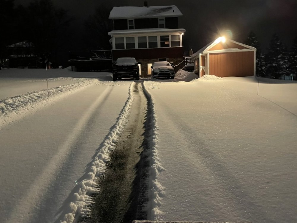
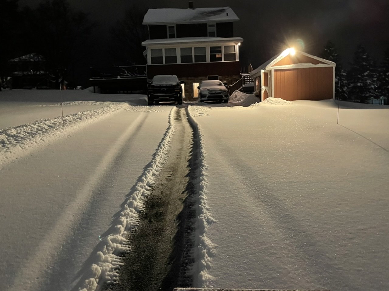
Snow has lightened up. An average of measurements is about 3.5" new. So the new storm total snowfall is 12.5" now. Edit: Adding last pic of the night, driveway was bare late this afternoon when this band moved in.