MAG5035
-
Posts
6,078 -
Joined
-
Last visited
Content Type
Profiles
Blogs
Forums
American Weather
Media Demo
Store
Gallery
Everything posted by MAG5035
-
Central PA - Winter 2020/2021 Part 2
MAG5035 replied to MAG5035's topic in Upstate New York/Pennsylvania
Hopefully we can stay more sleet for a good bit of this event. Looking at the dual pol products on the radar with the higher tilts it looks like the mixing layer is still pretty high up.. roughly about the 4,000ft level (up closer to the 850mb level). So that gives a good bit of time for droplets to refreeze thru the colder 925mb level to the surface. -
Central PA - Winter 2020/2021 Part 2
MAG5035 replied to MAG5035's topic in Upstate New York/Pennsylvania
Ugh. At least on the bright side being caught up in the traffic behind the wreck is always better than being caught in the actual wreck itself. -
Central PA - Winter 2020/2021 Part 2
MAG5035 replied to MAG5035's topic in Upstate New York/Pennsylvania
Looks like a pretty heavy area of precip about ready to get to your neck of the woods within the next 30 min. -
Central PA - Winter 2020/2021 Part 2
MAG5035 replied to MAG5035's topic in Upstate New York/Pennsylvania
On a lighter note, CTP point and click FTW apparently with the 6-12" 48+ hrs out just thru Thursday daytime. Boy if only... lol.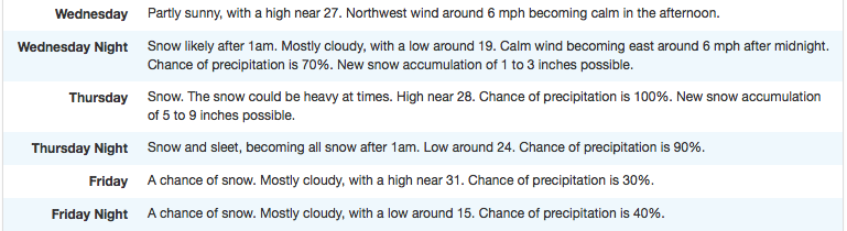
-
Central PA - Winter 2020/2021 Part 2
MAG5035 replied to MAG5035's topic in Upstate New York/Pennsylvania
29ºF and moderate mixed precip. Call it maybe a 60/40 sleet to freezing rain blend with a little bit of glazed-in sleet accumulation on untreated stuff already. Tonight's gonna suck. -
Central PA - Winter 2020/2021 Part 2
MAG5035 replied to MAG5035's topic in Upstate New York/Pennsylvania
Yea it's def attainable in the warning area. The main consequences of the models trending NW the last several runs are aloft, with much more robust warming at the 850mb and 925mb level, especially looking at today's runs. Surface CAD is still about the same which will maintain freezing rain, and I know it's above freezing in some spots right now but dew points are mostly in the 20s and this is coming overnight as well. I'm hoping more sleet is able to nose down and knock freezing rain down some here. This is my point and click for tonight, then 12ºF for a low tomorrow night, ugh. -
Central PA - Winter 2020/2021 Part 2
MAG5035 replied to MAG5035's topic in Upstate New York/Pennsylvania
The positives I see for Thursday are a better positioned high pressure to the north and the fact that this is coming pretty quickly on the heels of tonight's system...which about the only thing that's gonna be good for other than ice tonight is finally moving the gradient some as we do have some half decent cold that will come in behind. That aforementioned high actually builds overhead before shifting north of us as this next system approached. So I think we can at least get widespread front end snow if this stronger high holds in. That's part of what sunk us with the current one, which I've mentioned a couple times. Problems I see are that the overall mean trough axis is still going to be similarly positioned to where it is now (a bit too far west for my liking) and that's going to present the opportunity for this to track like the current system, potentially sending the surface low up the west side of the apps to an eventual transfer to the coast. Southern tier is pretty vulnerable to mixing in this setup IMO. Looking at mid-level features, even the Euro is a bit left of my liking with the 850mb low (roughly taking that overhead). The GFS and || GFS had a more focused 850mb low that went west and drew a stronger southerly flow and more mix. The stronger surface high to the north is extremely important for front end snow and maybe getting this low pressure under us, although I"m somewhat pessimistic of that happening without at least some surface low reflection carrying up west of the Apps up to at least the Ohio River. Probably don't want this to slow down at all either. The faster on the heels of the current system, the better chance it has at staying under us. -
Central PA - Winter 2020/2021 Part 2
MAG5035 replied to MAG5035's topic in Upstate New York/Pennsylvania
Can't help but marvel at the craziness of this weather event down in Texas. San Antonio socked in with heavy snow and FOURTEEN DEGREES. Brownsville, TX sitting colder than MDT right now at 32ºF and reporting light snow. The Brownsville NWS was saying in their discussion their ASOS sites aren't even equipped with freezing rain sensors bc well, guess that stuff never happens down there lol. -
Central PA - Winter 2020/2021 Part 2
MAG5035 replied to MAG5035's topic in Upstate New York/Pennsylvania
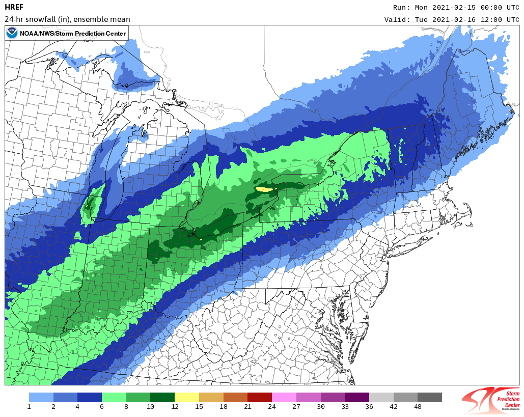
New 0z HREF showing support for upgrading that swath of watches to what would likely be an ice storm warning. This is the accrual algorithm. 24 hr snowfall: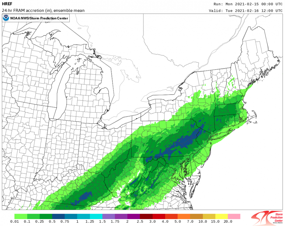
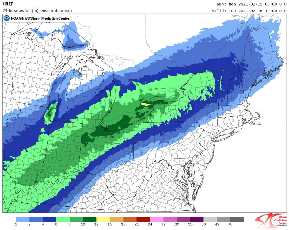
-
Central PA - Winter 2020/2021 Part 2
MAG5035 replied to MAG5035's topic in Upstate New York/Pennsylvania
Yea it's not going to get that far over, it's too cold there lol. However, pretty much all guidance has moved to running this surface low up the west side of the Apps basically up to SW PA before it shows any signs of jumping to the coast. That's not going to cut it, we need this to stay under PA. Really the only difference this makes for central PA is it just makes thing's icier (more freezing rain) since there is enough of a CAD setup to hang in surface temps near or below freezing over all the area for a good portion of the event before maybe spiking above freezing into the LSV below the turnpike right at the end. This is going to affect the northern tier's snow accumulation's some as the mixing is likely going to drive pretty far into northern PA now with a track like that. Still should be a half decent snowfall up there though. A stripe somewhere in the central counties is probably going to see a decent sleet accumulation (1-2") where somewhat deeper cold likes to stay anchored. The silver lining? The majority of the main wave of precip associated with the surface low Monday night is out of the area in about 10hrs or so. Then we can focus in on the next incoming mess Thursday. -
Central PA - Winter 2020/2021 Part 2
MAG5035 replied to MAG5035's topic in Upstate New York/Pennsylvania
Speaking of AFD updates haha. -
Central PA - Winter 2020/2021 Part 2
MAG5035 replied to MAG5035's topic in Upstate New York/Pennsylvania
Yup lol just saw. It does make sense since there's still time to review more guidance tonight ahead of this. Saw Mount Holly go right to warnings for half their CWA and figured CTP was about to do the same. So watches on a swath of south-central PA for the heightened ice concern (possible areas of .25"+). Some of the central/north central watch counties plus the non watch counties to advisory for more mixing eating into snow totals and likely more of a sleet event over ZR for the mix type. Also, I understand the LSV folks kind of tuning this out for the Thursday one but this next one starting well, tomorrow is still going to get everyone in here with at least a fairly high impact advisory level winter storm. -
Central PA - Winter 2020/2021 Part 2
MAG5035 replied to MAG5035's topic in Upstate New York/Pennsylvania
Ice storm warnings up for bordering counties over in Mount Holly CWA all the way down to Lancaster. This going to be another event CTP goes straight to warnings for a bunch of counties?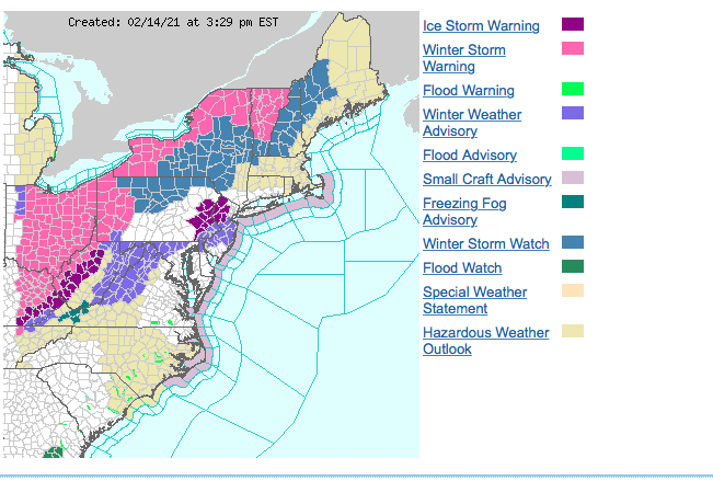
-
Central PA - Winter 2020/2021 Part 2
MAG5035 replied to MAG5035's topic in Upstate New York/Pennsylvania
Probably never. That is a gigantic expanse of the southern US under winter storm warnings. And those wind chill warnings that cover pretty much the entire north central US also are including a large portion of those winter storm warned counties. Def a historic and wide reaching arctic air outbreak. -
Central PA - Winter 2020/2021 Part 2
MAG5035 replied to MAG5035's topic in Upstate New York/Pennsylvania
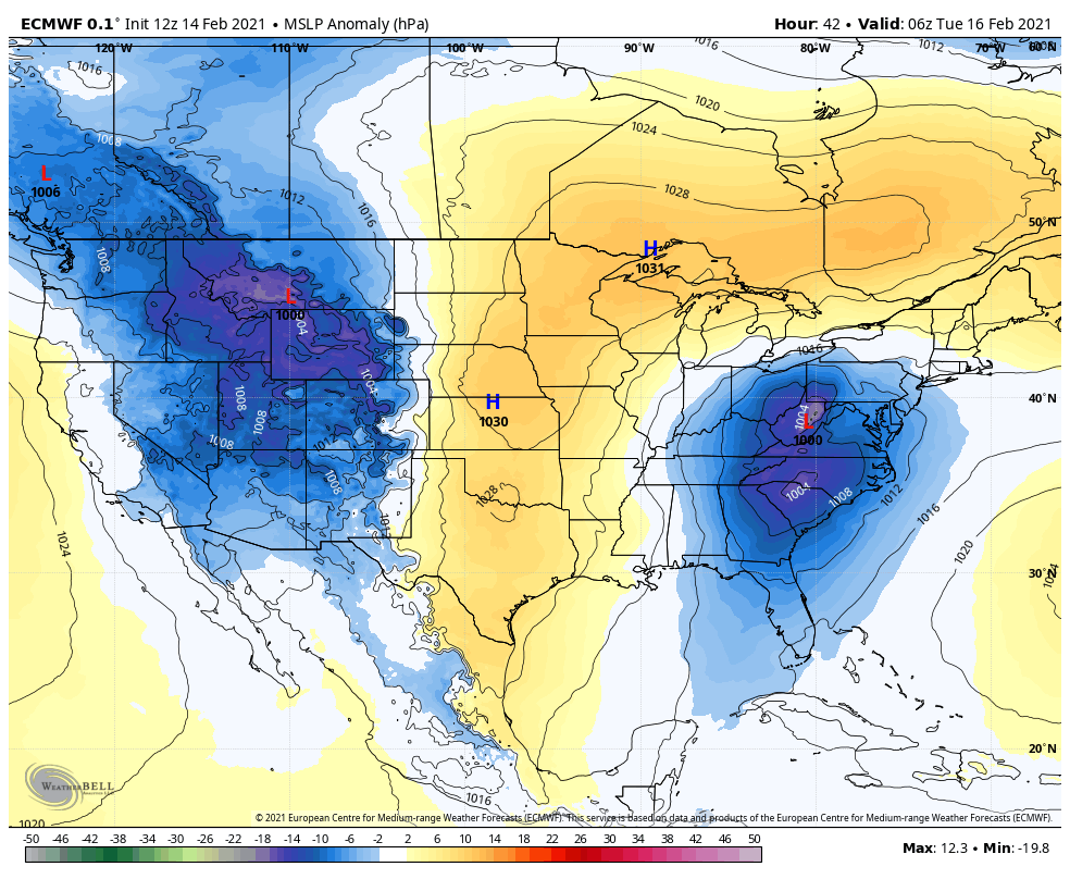
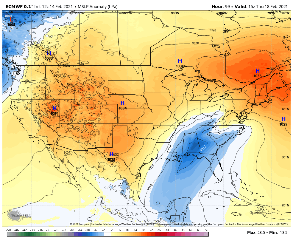
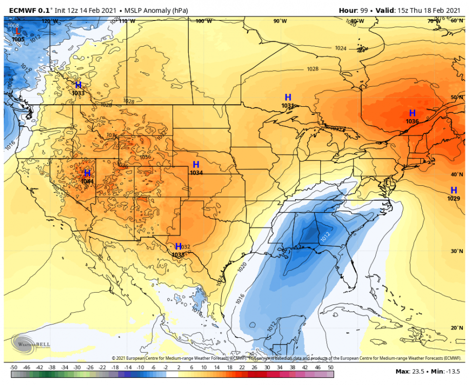
Only real big difference is the more robust high pressure progged to our north and NE for Thursday (and overall in the rest of the CONUS. That was the kind of high pressure models had north of us for Mon/Tues a few days ago whenever it was looking mostly snowy in PA. Helps deflect the surface low to the coast in time and at worst anchors a CAD wedge if the low tries to work up the other side of the Apps. Going to be extremely important to maintain that, because Thursday's storm could easily do the same thing the next one up seems destined to do, especially in the LSV. Mon/Tues storm arrival: Thursday storm arrival: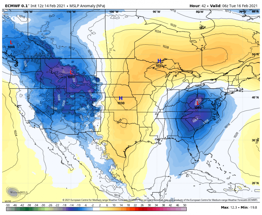
-
Central PA - Winter 2020/2021 Part 2
MAG5035 replied to MAG5035's topic in Upstate New York/Pennsylvania
CTP's latest update on Mon/Tues. I'd be ecstatic with that clean of a storm and 4-6"...but personally expecting a much messier outcome. I'm always a proponent of the cold hanging in better in C-PA than modeled, especially in the interior counties.. but CTP is really bullish inside the area boxed in by I-80 and the turnpike (N-S) and US 219 & US 11/15 (E-W). That area in particular is going to be the hardest to forecast, and clearly CTP is favoring a colder column and perhaps factoring climo in with the track. 12z Euro still the coldest aloft while having the most expansive freezing rain, which I still don't get how the p-types get ZR out of a large portion of the interior central showing solidly below zero at 925 and surface.. and even 850. Issue is, column also warms between 850mb all the way up to 700mb in this zone at least briefly with 700 temps right around 0ºC or slightly above in roughly the eastern half of PA on some guidance. So I think even if the mostly frozen precip did happen here that it could be more sleet than snow, which would easily knock those bullish totals down. Otherwise, my main points from last night's post are pretty much unchanged. I personally think CTP should consider watches for some south central counties (all current non-watch counties NW of Franklin/Perry counties as that would be the region with the best chance to achieve a stripe of .25"+ ice in the very possible event that we get more of a freezing rain/sleet deal vs the more snow/sleet event being portrayed there in CTP's forecast.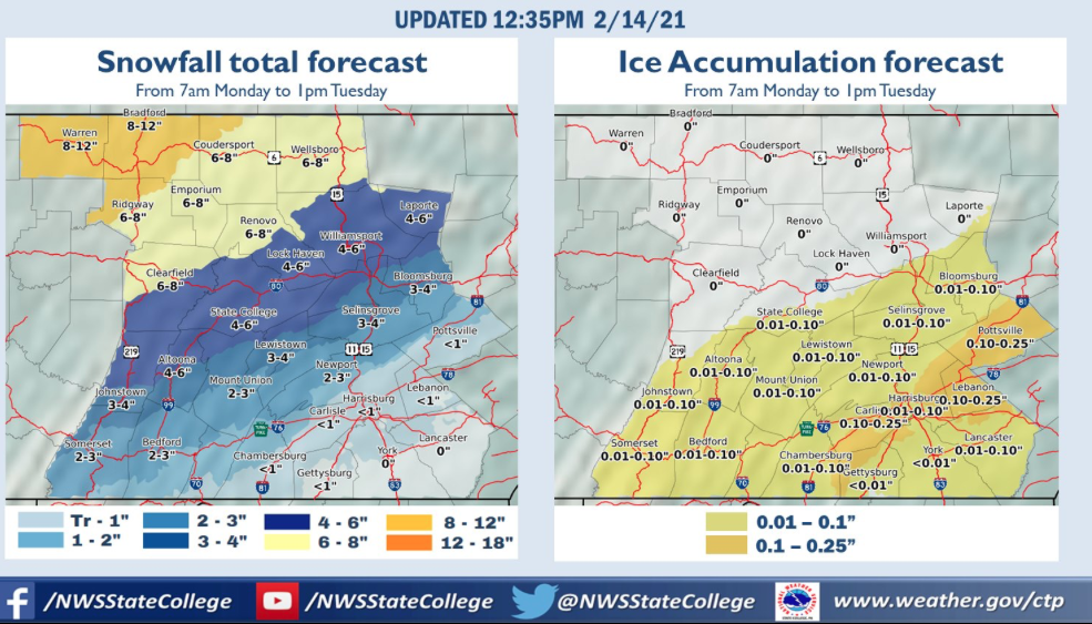
-
Central PA - Winter 2020/2021 Part 2
MAG5035 replied to MAG5035's topic in Upstate New York/Pennsylvania
As for conditions here it's still 23ºF with a solid freezing drizzle and some occasional snow grains. Untreated stuff is starting to get a really nasty thin glaze on it. -
Central PA - Winter 2020/2021 Part 2
MAG5035 replied to MAG5035's topic in Upstate New York/Pennsylvania
Yea the 0z guidance generally did not help the cause for more frozen precip further southeast in PA tonight. Models trended tighter to the apps tonight with the NAM actually taking the low right through western PA and the Euro getting underneath but showing reflection up into WV on the west side of the apps. GFS is mostly SE of PA but def edged tighter. Having the surface low really close isn't going to cut it here and obviously we're cooked if the NAM was actually right. My argument for a more frozen outcome than being modeled is heavily dependent on the low pressure actually staying SE of PA with some room to spare. That would allow a fighting chance for the surface cold air to bleed into PA more and also a SE track would imply the thermal boundaries aloft are shifted SE as well to where it favors more frozen. Already mentioned about the high earlier with how the portion that stretches north of us across Ontario/Quebec seems weaker and also a bit further north than a couple days ago. This was one of the keys for holding the cold air east of the mountains and helping keep the low SE. Should note that Euro looks the strongest of the models with that particular feature. I would consider the runs at least thru 12z (and probably thru 0z) to see where we're at today and also to have a good look at where this initial wave of precip running up Sunday night is going to be placed before making any rash decisions. But in light of how things look tonight this is shifting towards these main things as it stands. 1- How much ice does the LSV (SE of I-81) see before a potential change to rain. 2 - What the dominant mix type (freezing rain vs sleet) is going to be in the portion of central PA NW of I-81 including places like IPT, UNV, AOO, JST, Carlisle, Bedford, etc. and if some snow can still occur (more possible the further NW one goes). And 3 - How much potential mixing cuts into the more predominant snow potential for the rest of the north-central and NW portion of C-PA (NW of IPT over to Clearfield, St Mary's, Bradford, etc). This still has time to shift back the other way to some degree and the position of the cold air boundary is going to be extremely important, especially with how well the models represent it. This low is basically going to ride this baroclinic zone and it's not going to be something that easily yanks the cold air east towards a rapidly deepening surface low in time. -
Central PA - Winter 2020/2021 Part 2
MAG5035 replied to MAG5035's topic in Upstate New York/Pennsylvania
Thursday was actually the one I was more worried about cutting/p-type issues vs the current upcoming Mon/Tues event . The current system is occurring in the middle of a seismic shift of the NAO and AO neutralizing and possibly going somewhat positive from being like -4 and -6 respectively. With the EPO/WPO tending positive, PNA trending positive, and no intense NAO blocking to counter...our luck is probably going to run out soon with our nice run with a lack of major cutters. -
Central PA - Winter 2020/2021 Part 2
MAG5035 replied to MAG5035's topic in Upstate New York/Pennsylvania
Been busy and mostly away from the computer good part of the day. Was a nice freezing drizzly 21-23ºF here today. I'm still not really sure what to make of the precip type situation with this. It seems like models have weakened the portion of the high pressure stretching north of us over to Quebec to a degree. Really been making this more of a straight-up gradient vs much of a traditional CAD wedge with Western/NW PA in a much better situation than the LSV or even the central counties below I-80 currently. Track of the surface low continuing to be mostly under us would figure to support more frozen. Kind of suspect about GFS and NAM pretty much routing sub-freezing surface temps out of all the Sus Valley. Euro is simultaneously the coldest column and iciest outcome freezing rain wise. I don't understand why it's still printing out such a big stripe of ZR, especially in the central counties. KAOO at -4ºC surface, -5ºC 925mb, and -1ºC 850mb at Hr 66 after 0.3" of ZR from 60-66 is not a ZR profile, no way. At least the thermals on the warmer models make a bit more sense vs the p-type. C-PA is right smack in the middle of the baroclinic zone and potential transition zones and determining where everything's going to setup is very difficult at this point. I still lean to the colder end of the spectrum and it definitely appears that CTP does too. Just something about that low tracking SE of the region with plenty of surface to try to press and bleed in. However, the aforementioned high pressure appearing a bit weaker on the end of the "banana" that stretches over to Quebec would seemingly limit driving down a CAD wedge east of the mountains to hold in the LSV SE of I-81 later in the event. On the other hand, models like to underestimate the CAD. Going to have to monitor how temps go tomorrow and how that front running wave of precip tracks Sun night into Monday ahead of the main wave to get a better lock on the positioning of the temp gradient. -
Central PA - Winter 2020/2021 Part 2
MAG5035 replied to MAG5035's topic in Upstate New York/Pennsylvania
I'll gladly take the milder temps and active storm track we have right now over having the extreme cold. Especially since we are still cold enough to mostly maintain the pack that's on the ground. We've had conflicting signals via the teleconnections for a lot of this exceptional NAO/AO blocking period with a mostly -PNA and a solid MJO magnitude that's been floating in the Phase 6-7 region. (currently 7) Want to know what they usually translate to, especially in 6? Not going to get into a whole thing and stat lesson on the significance % maps but regions in that blue or purple shows high correlation to the temperature pattern. That's why phases 4-6 are frowned upon greatly in the eastern US, esp during a Nina. Phase 7 is a warm phase in the east too, but not as strongly. But the gradient pattern we're in and the arctic air not completely dropping in to the east makes alot of sense when this is considered. I think it's a blessing in disguise personally. You don't have such strong NAO/AO blocking then you guys are talking about still having the AC on. You don't have the conflicting MJO signal and it's conceivable its frigid in PA and we're lamenting DC and VA getting all the snow. And I guarantee you guys wouldn't be so disappointed we're missing out on it being -10 if that happened.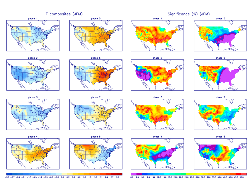
-
Central PA - Winter 2020/2021 Part 2
MAG5035 replied to MAG5035's topic in Upstate New York/Pennsylvania
Yea, I've been considering that aspect. Typically an amplification as major as one taking extreme winter weather pretty much to old Mexico and the Gulf Coast generally wouldn't bode well for us in the eastern US but we still have the sprawling high pressure and the cold air to the north and the low attacking it from the Gulf. Majority of guidance and ensembles keep this surface low below us, initially on the west side of the Apps in the SE but eventually going to the Mid-Atlantic coast. Not a wound up deep low either. So this is definitely looking like a pretty high impact winter storm for C-PA, but details on P-type are anyone's guess really at this point. I still personally prefer more frozen (snow/sleet) solutions, like the GFS. Should note there is a huge difference in surface temps GFS vs Euro (8-10ºF) during the height of this. Even with that, I don't really buy the Euro's expansive ZR, especially outside of the southern tier where the column would suggest sleet more than ZR. Why do I prefer the colder solutions? Despite the core of the arctic air not pushing into our region, it slides east across Ontario and Quebec with that sprawling high pressure. So I think surface/low level cold is going to bleed down into PA pretty efficiently, especially with the majority of guidance keeping the surface low underneath us. It seems that 700-850mb zone is most likely region this busts above 0ºC and that's high enough in the column that i'd be considering sleet as predominant mix over ZR, although there's going to be a stripe of more significant ZR to deal with somewhere as well.. and our southern tier near the Mason-Dixon is a place to watch for that possibility . -
Central PA - Winter 2020/2021 Part 2
MAG5035 replied to MAG5035's topic in Upstate New York/Pennsylvania
Just measured 3.4", with some lingering light snow still falling. -
Central PA - Winter 2020/2021 Part 2
MAG5035 replied to MAG5035's topic in Upstate New York/Pennsylvania
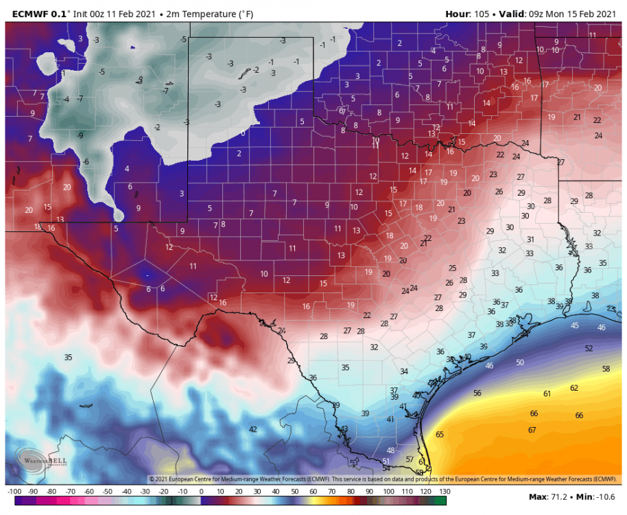
Lol @MillvilleWx might win "coldest snowstorm of the winter" down there in Midland, TX with the storm that becomes our Tuesday event. Yes those temps are in ºF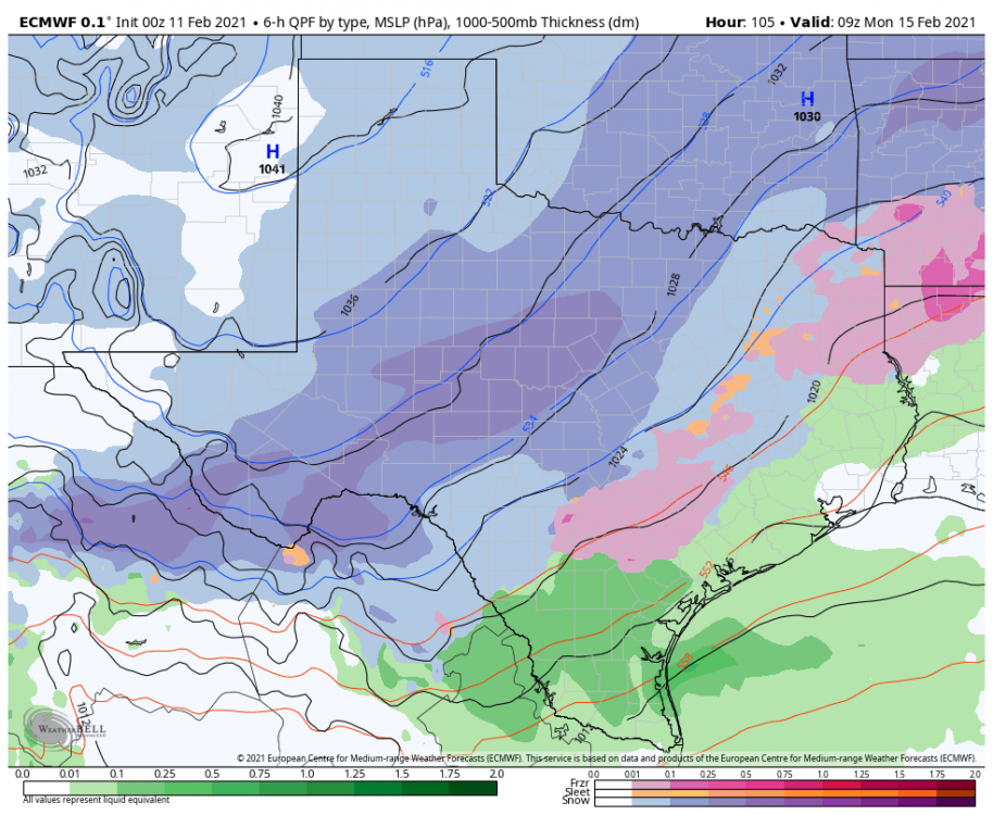
-
Central PA - Winter 2020/2021 Part 2
MAG5035 replied to MAG5035's topic in Upstate New York/Pennsylvania
Looked like that upper band of snow is still over Northern Cambria on radar, not getting anything?