MAG5035
-
Posts
6,078 -
Joined
-
Last visited
Content Type
Profiles
Blogs
Forums
American Weather
Media Demo
Store
Gallery
Everything posted by MAG5035
-
Central PA - Winter 2020/2021 Part 2
MAG5035 replied to MAG5035's topic in Upstate New York/Pennsylvania
Much better flakes now and moderate-heavy rate. Binocular check of the snowboard with the flood light on already looks like over a half inch. -
Central PA - Winter 2020/2021 Part 2
MAG5035 replied to MAG5035's topic in Upstate New York/Pennsylvania
Yep same over here, a nice moderate pixie dust snow for now. Getting this early swath of snow to set over the area is gonna be a big part of hopefully getting pretty well into our forecast range of the advisory (3-7"). I think we're in pretty good shape. There's a patch of some more enhanced echoes on radar over JST that should try to shift this way here within the next hour or so. -
Central PA - Winter 2020/2021 Part 2
MAG5035 replied to MAG5035's topic in Upstate New York/Pennsylvania
Flurries starting here, 25ºF. -
Central PA - Winter 2020/2021 Part 2
MAG5035 replied to MAG5035's topic in Upstate New York/Pennsylvania
Great catch. And the 0z sounding (weather balloon) is hard data too. This was my worry about the southern tier in terms of a getting a warm layer somewhere in between 850-700mb. Yea it will wet bulb down, but more robust WAA there is already being noted. Fortunately for our region I think this has been trending towards minimizing the threat for sleet/mixed (0z NAM didn't have it getting very far across the mason-dixon). But there's still a decent possibility of pingers at some point to consider in likely the bottom tier of LSV counties. -
Central PA - Winter 2020/2021 Part 2
MAG5035 replied to MAG5035's topic in Upstate New York/Pennsylvania
To clarify a bit, holy crap the NAM is sleeting on DC. 2.5-3"+ on both the NAMs lol. -
Central PA - Winter 2020/2021 Part 2
MAG5035 replied to MAG5035's topic in Upstate New York/Pennsylvania
Boy I bet the DC metro folks are loving seeing the 0z NAM and some of the differences between other models this close to game time (||GFS vs GFS and Euro). 3k gives them almost nothing snowy and 12k NAM isn't much better and the 0z HRRR hits them good. My only worry for this region is some sleet mixing in at some point for a little bit in the southern counties. At least none of us are riding THAT edge for this event. -
Central PA - Winter 2020/2021 Part 2
MAG5035 replied to MAG5035's topic in Upstate New York/Pennsylvania
Got some echoes overhead, just waiting for it to hit the ground. -
Central PA - Winter 2020/2021 Part 2
MAG5035 replied to MAG5035's topic in Upstate New York/Pennsylvania
I don't know if it's necessarily a Nina thing. Models being too high with QPF certainly isn't anything new.. especially on the high resolution short range stuff like the NAM and also the RGEM at times too. Pattern is progressive but we're also not phasing shortwaves or amplifying a big time low here in this alignment, and that's a good thing with where that 500mb trough is postioned currently with no NAO/AO blocking anymore. That's why the overrunning aspect of this wave is probably going to be the main part of the storm with the weak surface low and weak mid-level features. We've had a few of these type events this year too. -
Central PA - Winter 2020/2021 Part 2
MAG5035 replied to MAG5035's topic in Upstate New York/Pennsylvania
A big key to what we're going to see snow wise with this system is what happens right up front late tonight into early tomorrow with that finger of early warm advection snows that develops and where it's placed as that probably will be the best snows ratio wise and could throw a stripe of a few inches right off the bat to whoever gets it.That's really been the name of the game with this system since last week, what it does on the front end... even with it being a much colder system overall than it was looking at that point. At any rate, it seemed like a good bit of guidance today (especially the short term and high res stuff) places this early stuff closer to a JST-UNV-IPT line than say a Cumberland to MDT one and then the main surge of precip fills in the rest where it will probably be heavier overall in the southern tier. This is actually most important for that corridor (JST/UNV/IPT/FIG) because this may be a low end advisory or worse without it in the central counties. I'd wager the folks that gets a good piece of the early stuff and transitions into the main surge without wasting a period of light or non-consequential rates are probably going to be the ones that see the best accumulations for the whole event. And if that actually does end up back as far as that JST-IPT corridor, I'd def be more worried about the implications of eventual mixing in the LSV counties. NAM and related near term guidance is the mixiest still, while generally everything else minimizes the mixing above the mason-dixon line. Still have the same concerns with the 500mb mean trough centered west over the central US as well as the mid-level features west of PA and associated WAA busting 0ºC somewhere in that 850-700 layer in esp the LSV. The trend the last couple days has been a bit of a SE shift in the heavy swath and especially an overall toning down on QPF. I think this is basically a 4-8" for all the regulars in here. Clearfield and Williamsport should eventually at least get to 3-4" by the end of this event. Places like AOO/UNV 5-6" and the best chance of a consistent 6"+ swath likely resides closer to the turnpike. Below the turnpike in the southern tier/LSV has the best QPF for widespread 6"+ but that directly depends on if the mixing happens. If it does, I still think everyone gets 3-4". The upper end of this is probably 10". -
Central PA - Winter 2020/2021 Part 2
MAG5035 replied to MAG5035's topic in Upstate New York/Pennsylvania
Yea this wasn't really looking like much more than a 6-12" type event at any point in the heavy axis, other than like the 18z NAM. Another thing I didn't mention on my long post earlier going over the mid-level lows was that we're not really deepening the coastal storm. It's just an overrunning wave attacking a cold high pressure with overrunning WAA precip in either one or two separate heavier precip areas depending on the model. And the weak 850mb low never goes to the coast nor strengthens much, with the parent low staying west of here. So you don't develop the anomalous easterly flow you want to look for to start getting the widespread big amounts and intense banding. -
Central PA - Winter 2020/2021 Part 2
MAG5035 replied to MAG5035's topic in Upstate New York/Pennsylvania
Temps already back to 24°F here with some fluffy upslope snow showers starting to get things covered up again. Spent enough time above freezing this morning that ice is mostly off the trees. Was hard to measure. I called it about a half inch of sleet which combined with the freezing rain made quite the ice layer on the snow. Actual ice accrual on trees and such looked fairly similar to the mostly ZR event I got at the end of December (which I measured 0.2”). Snowpack avg depth after the ice is about 8-9” with as low as 4” and as high as over a foot.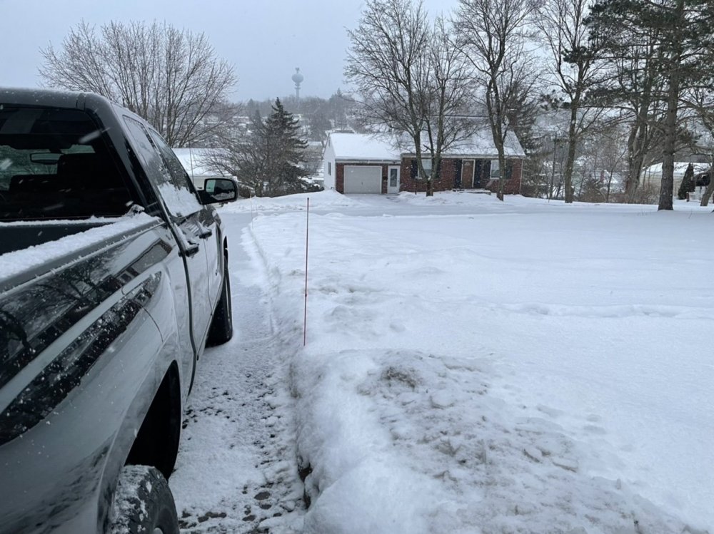
-
Central PA - Winter 2020/2021 Part 2
MAG5035 replied to MAG5035's topic in Upstate New York/Pennsylvania
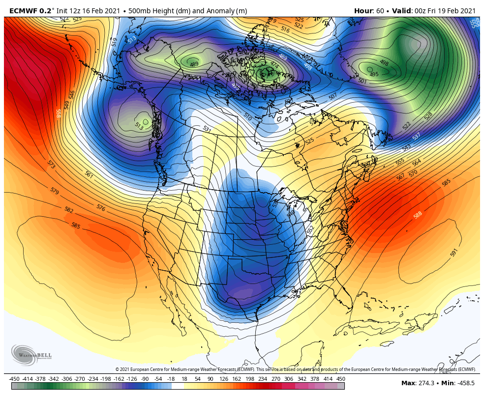
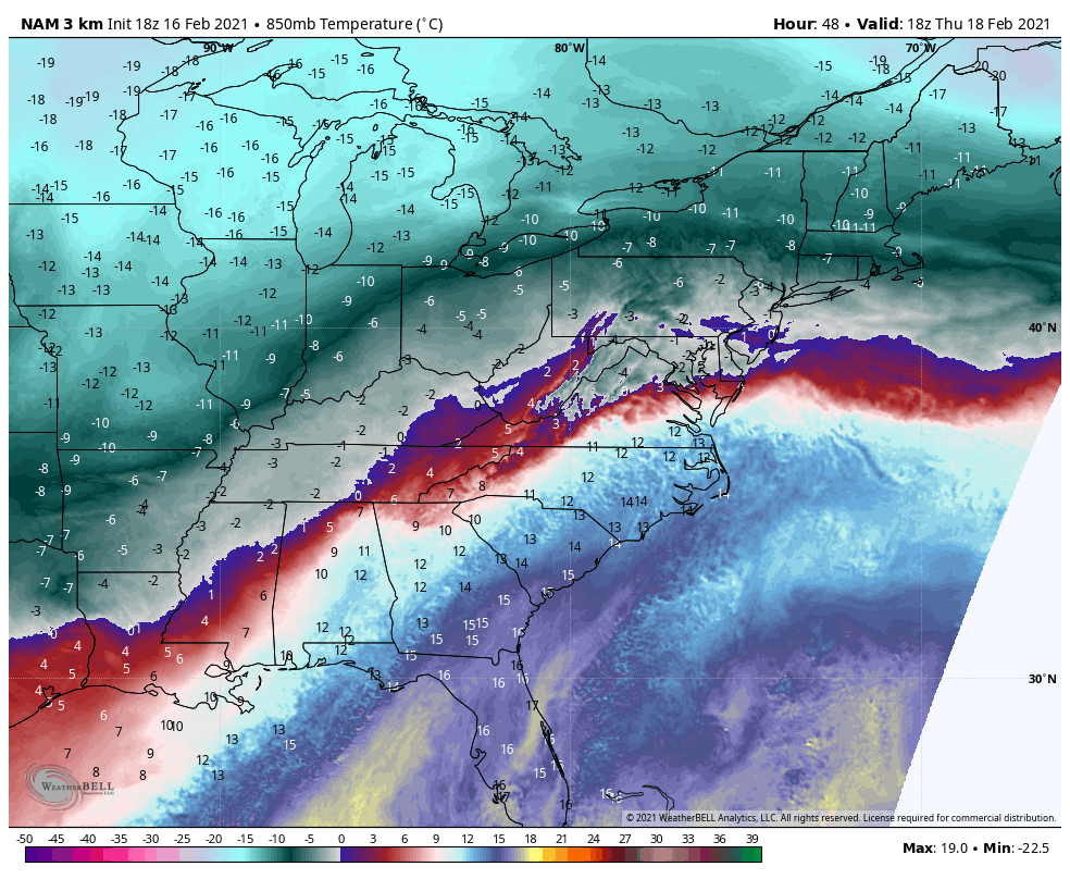
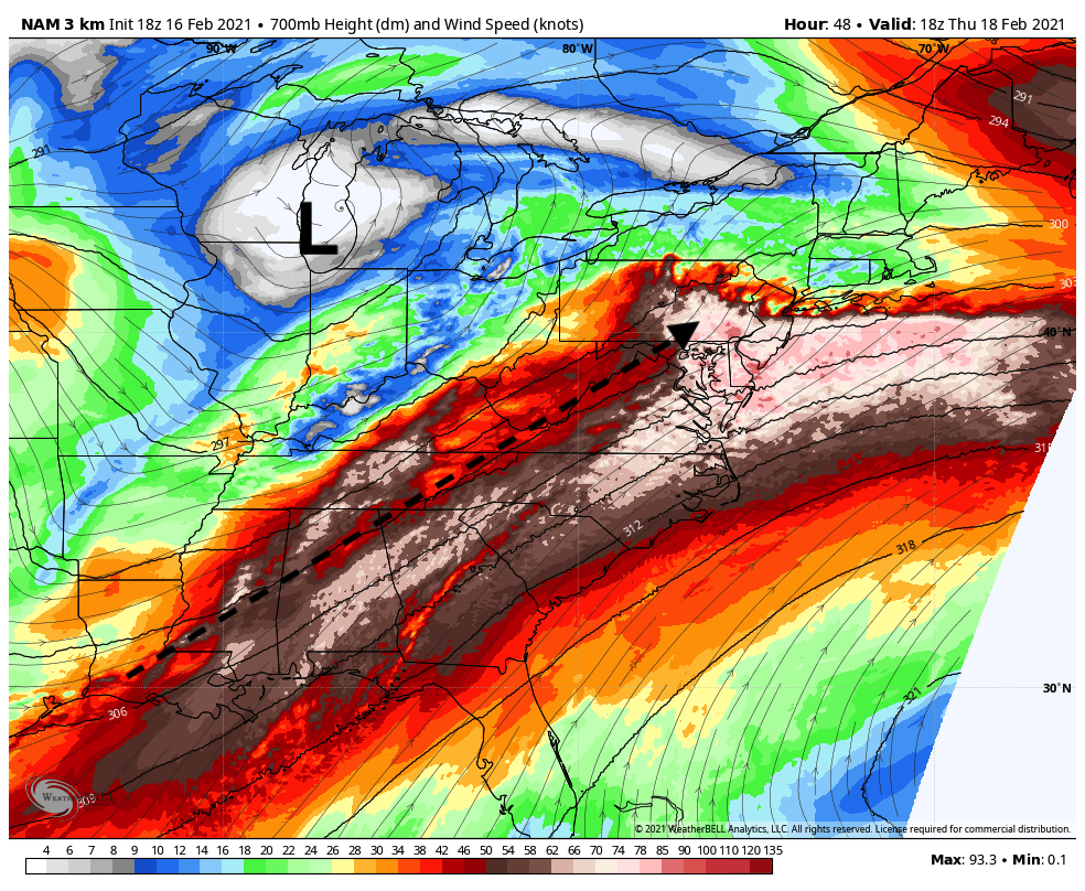
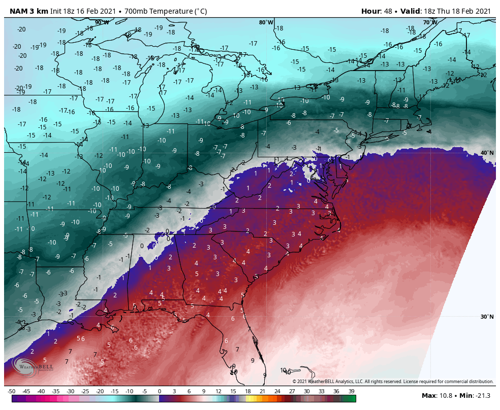
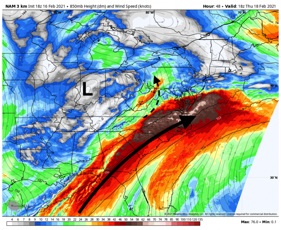
The bigger concern I have for especially the LSV wrt to some mixing later in the storm deals with the mid-level features at 850 and 700mb. The 850 low and 700.. trough are based west of the area. Fortunately these features are weak because a more dynamic phasing storm would assuredly be cutting west given 500mb positioning of the mean trough still over the middle of the country into Texas. Here's the 500mb mid-storm via the Euro. You wouldn't think at first glance CTP (or southern PA here in the Euro's case) is in the midst of getting a significant snowfall but thats the magic of when the features below 17k feet (500mb) are at least somewhat favorable and there's cold air. This isn't the first time we've played this game this winter either. Now going to show what the latest 3k NAM had with it's mid level features. The NAM is definitely on the most amped side of guidance, but same general idea is applying to the other guidance as well. 850mb heights/wind 850 temps First off, you can see the big difference between this one and the last storm... where the 50-60kt+ jet is nosed over SE VA and the Delmarva instead of right directly over PA like last night. There is some southerly flow into PA (enhanced a bit on the west side of the Laurel's) but not the major jet that torches the layer. That big arrow i drew doesn't show it well but the streamlines show that flow turning back a bit toward a due southerly flow over the Delmarva keeping the 0ºC line somewhat close. But overall, that level is okay for us but we don't want to slow down and amp this storm up much more or your going to direct that southerly flow more towards southern/southeast PA. Now 700mb winds/heights 700mb temps This is the level (and possibly somewhat between the 850 and 700mb) that I'm most concerned about for mixing here in our region. You can already see why the NAM has so much sleet as a pretty strong 700mb jet runs through the Mid-Atlantic into PA.. There's going to be some significant WAA in that layer either way (which could cap snow ratios to a degree) but that 0ºC line is teetering near the LSV at 48 when the bulk of the precip is happening. Above 0ºC 700mb air does work into roughly the SE quarter of PA by hr 54. Now as I said..the NAM is generally the most amped with the features I pointed out right now, but consider where we ended up last night. WAA aloft ended up being so strong that even the counties in the north that we're supposed to still 6+ of snow at the beginning of yesterday ended up not seeing anywhere near that. Now let me add the disclaimer that this event should drop some nice snow up front for everyone. With that said, obviously my concern is more robust warming aloft than even the NAM has modeled... especially at 700mb considering how far west the low feature is. You get that sneaky thin area up somewhere between 700-800mb of above 0ºC air and suddenly your pinging away. So def something to keep in consideration.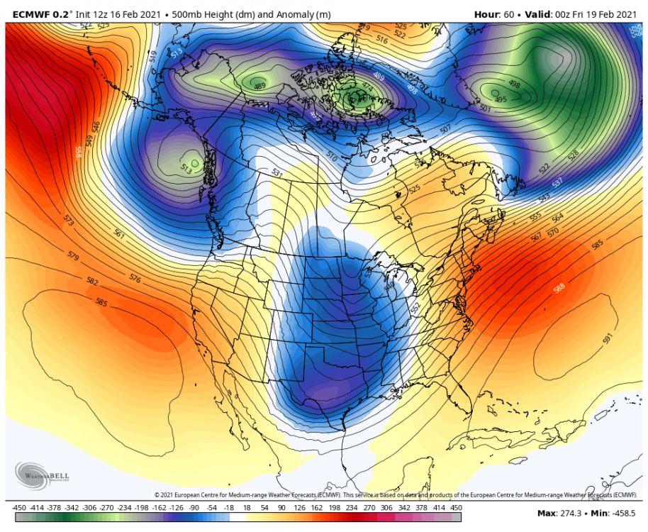


-
Central PA - Winter 2020/2021 Part 2
MAG5035 replied to MAG5035's topic in Upstate New York/Pennsylvania
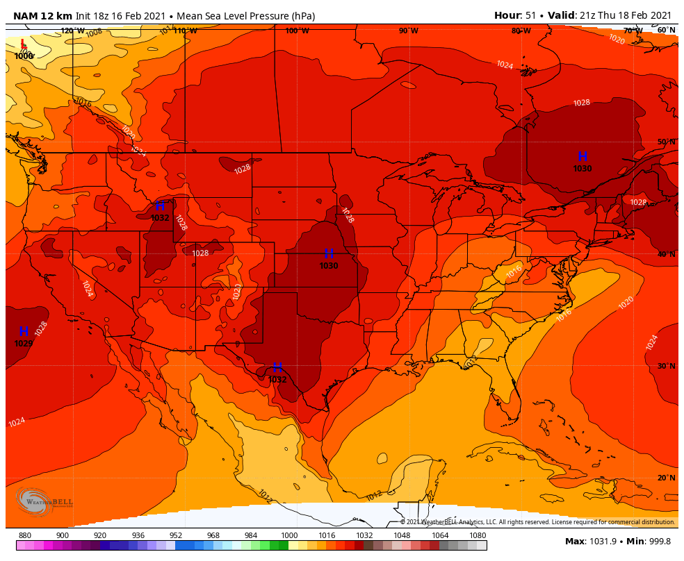
It's a pretty weak low pressure system overall that's trying to press up into what will be a much better positioned high pressure this go around. I don't think it's really fighting anything, it's actually more focused with a singular significant press of overrunning precip vs the Euro or the ||GFS which seems to have two separate surges of heavier precip. Euro op looked somewhat stronger with the high pressure so that likely had a hand in kind of focusing on the southern tier more. The surface "low" you see west of the mountains is part of the overall low pressure area but the colder denser air draining down via the high pressure in place gives it that two low look. This is an A with a pretty weak surface low. Classic overrunning look.
-
Central PA - Winter 2020/2021 Part 2
MAG5035 replied to MAG5035's topic in Upstate New York/Pennsylvania
Here's the sleet total map, good lord lol.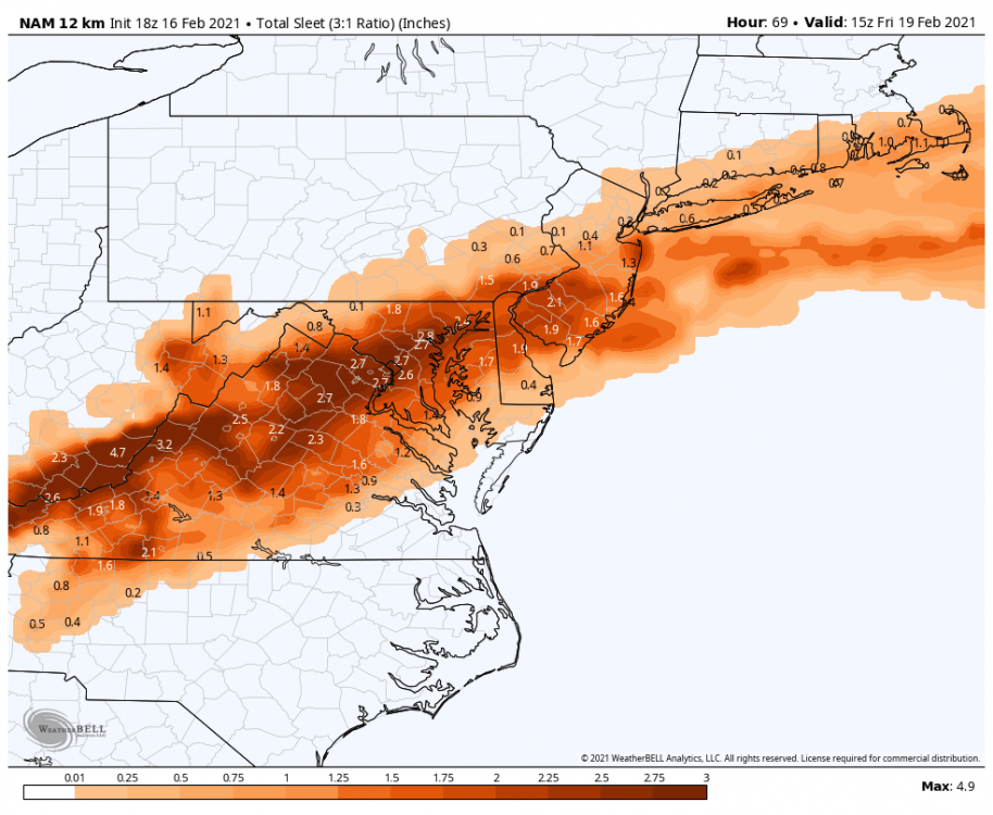
-
Central PA - Winter 2020/2021 Part 2
MAG5035 replied to MAG5035's topic in Upstate New York/Pennsylvania
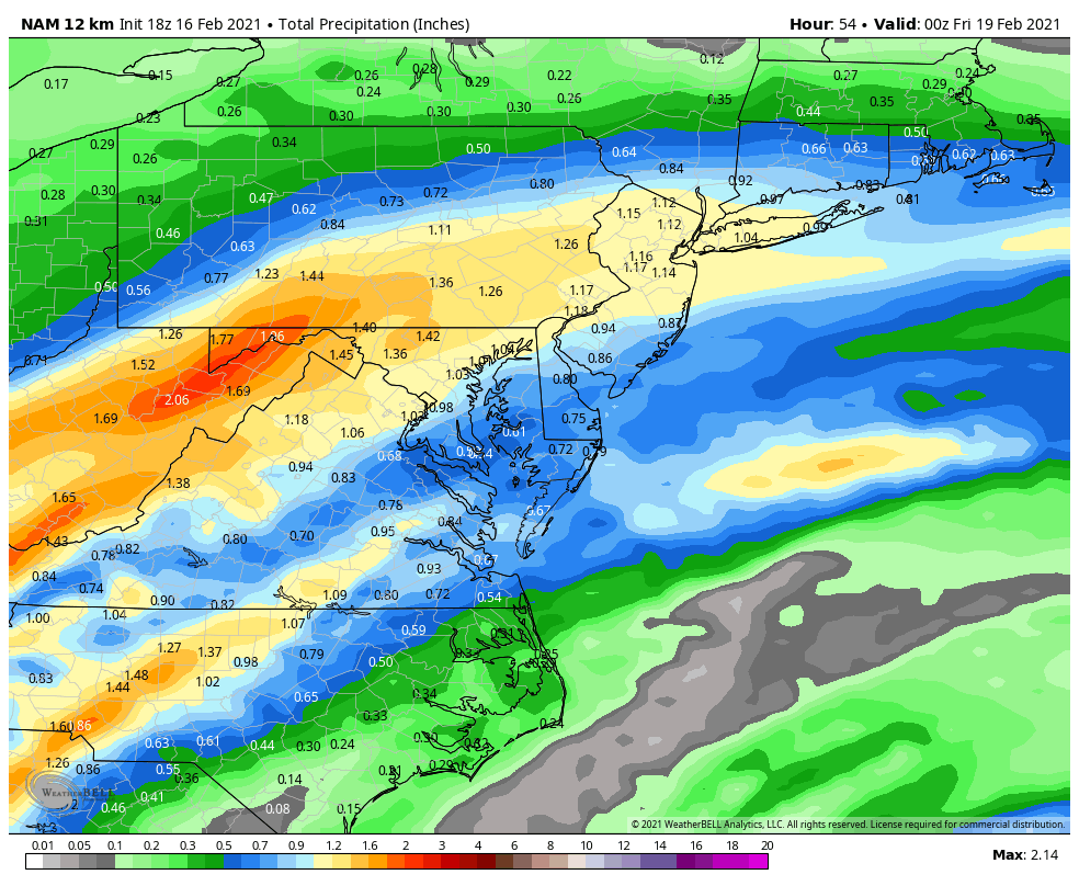
Pretty close. MDT is getting 14.1 Kuchera on 1.36" QPF.. so basically a 10.4 to 1 avg snow ratio.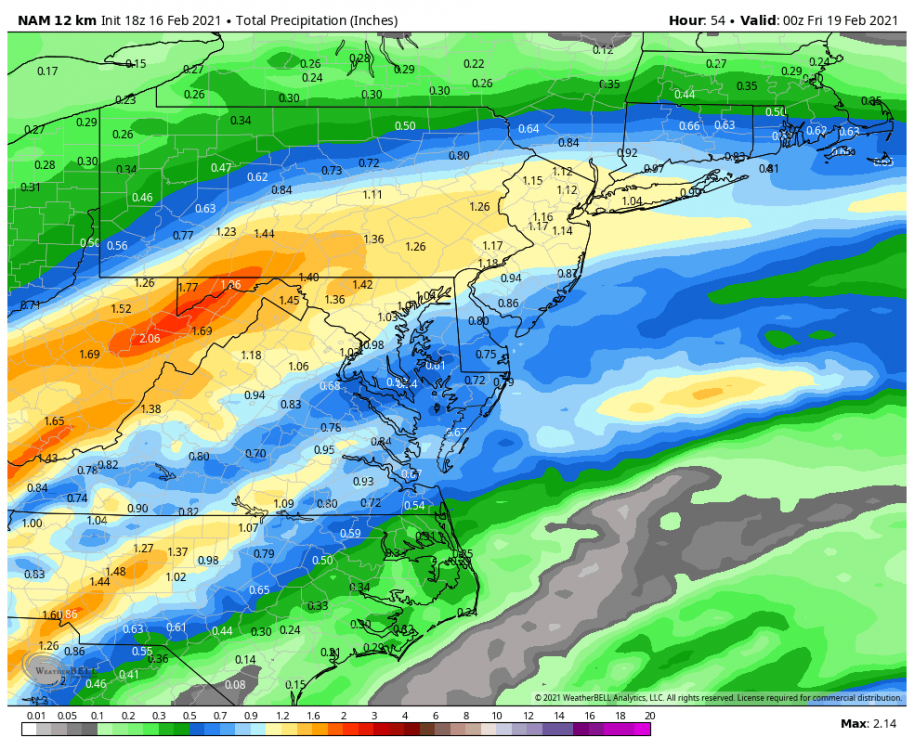
-
Central PA - Winter 2020/2021 Part 2
MAG5035 replied to MAG5035's topic in Upstate New York/Pennsylvania
That's a classic 18z NAM job if i've ever seen one lol. 10"+ roughly southeast half of PA on the 10:1, and Kuchera coming out to be pretty close to the 10:1 in that stripe. DC and surrounding has 2-4" of sleet. -
Central PA - Winter 2020/2021 Part 2
MAG5035 replied to MAG5035's topic in Upstate New York/Pennsylvania
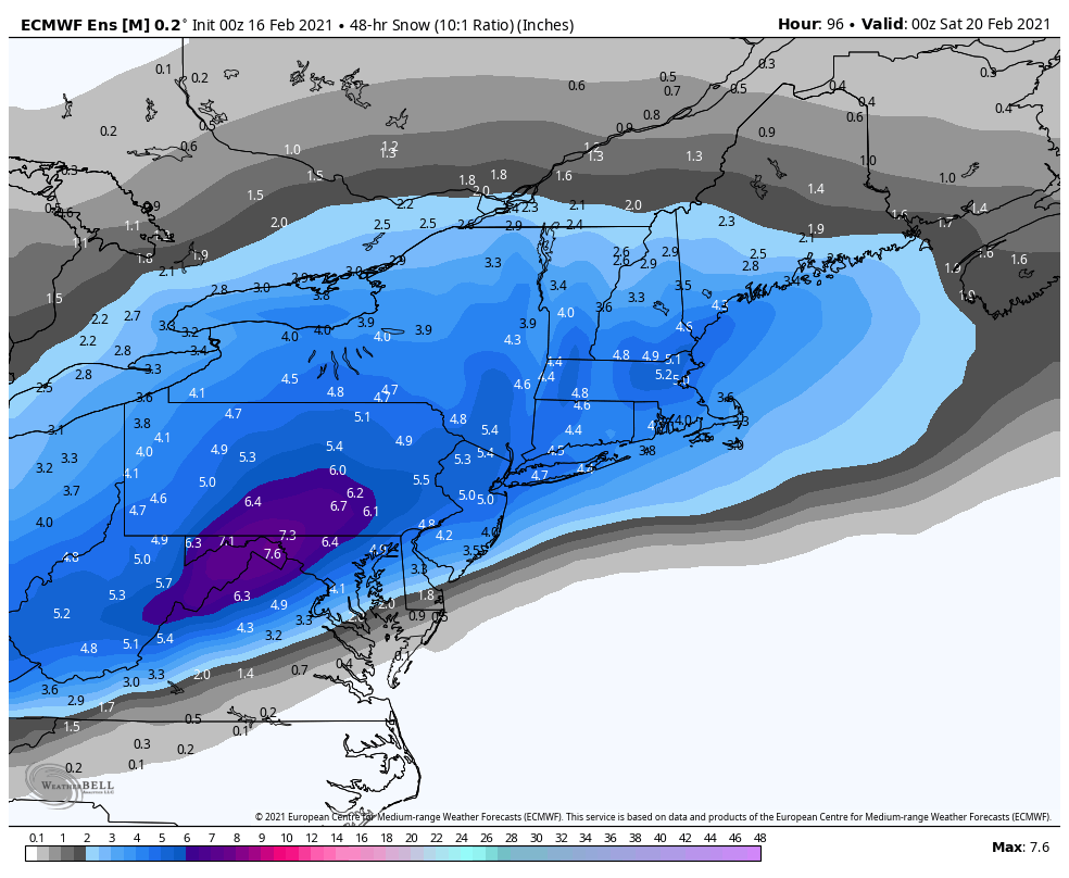
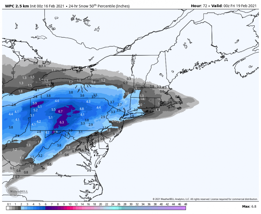
0z Euro and Euro ensemble check out for Thursday's event. Mostly all snow for everyone in here. Also while I"m at it might as well throw on the 0z WPC guidance blend. That only goes out to 72hr, so probably more snow to be had in the Sus Valley. 0z Euro ensemble 0z WPC guidance (50th percentile snowfall)
-
Central PA - Winter 2020/2021 Part 2
MAG5035 replied to MAG5035's topic in Upstate New York/Pennsylvania
Starting to notice the ice on the trees some now. P-type is mainly freezing rain with temp floating 32ish. Do have a fairly stiff SSE breeze now, which may help mix temps up a degree or two (KAOO at 34ºF). The wind probably won't help matters on the ridges though, where the bigger ice accumulations likely will be. -
Central PA - Winter 2020/2021 Part 2
MAG5035 replied to MAG5035's topic in Upstate New York/Pennsylvania
The || GFS does as well. Both are mostly snow with a bit of late mix in the LSV on regular GFS while the Para-GFS never gets mix line above the mason-dixon. -
Central PA - Winter 2020/2021 Part 2
MAG5035 replied to MAG5035's topic in Upstate New York/Pennsylvania
Pretty much all guidance except the NAM (until 0z tonight) have been showing good front snows with varying degrees of mixing later in the event (Euro pretty much an all snow event back in our area). The new 0z NAM now joining the party with the bigger front end thump. So def not a fluke or anything, but a little early to be including accums like that in the grid forecasts considering how rapidly this current one went sideways the last few days. -
Central PA - Winter 2020/2021 Part 2
MAG5035 replied to MAG5035's topic in Upstate New York/Pennsylvania
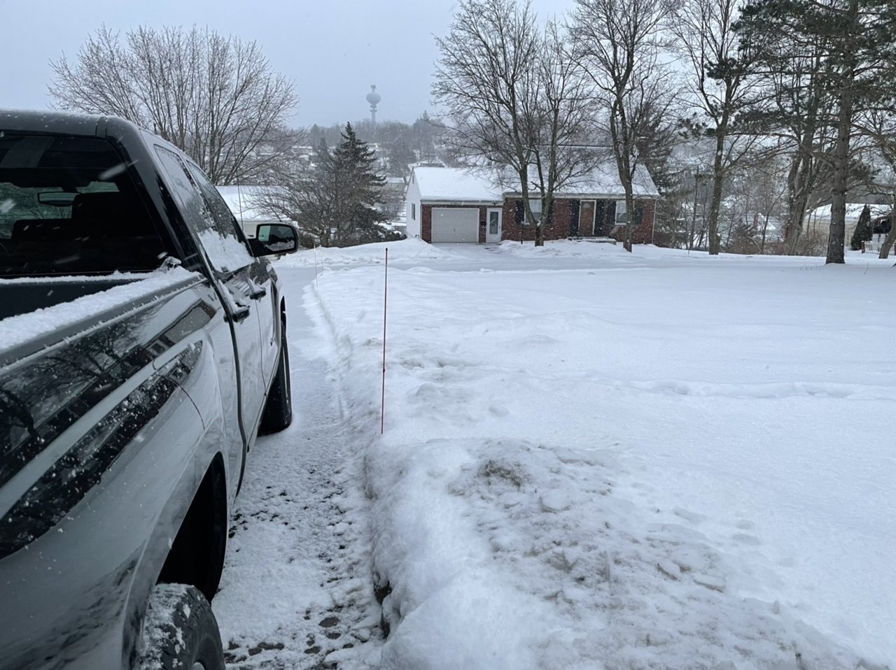
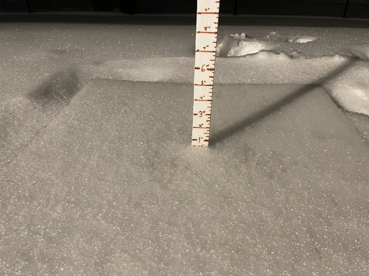
Might as well put up a pic of the “ice board”. A little over a half inch of ice encased sleet. Ice accrual on trees isn’t too notable yet.
-
Central PA - Winter 2020/2021 Part 2
MAG5035 replied to MAG5035's topic in Upstate New York/Pennsylvania
Pinging away here as well. Pretty much all sleet falling moderately. -
Central PA - Winter 2020/2021 Part 2
MAG5035 replied to MAG5035's topic in Upstate New York/Pennsylvania
0z NAM def coming in colder vs 18 and 12z with the mixing portion of the Thursday storm. Very intense front end thump of snow as well. -
Central PA - Winter 2020/2021 Part 2
MAG5035 replied to MAG5035's topic in Upstate New York/Pennsylvania
No sleet at all? -
Central PA - Winter 2020/2021 Part 2
MAG5035 replied to MAG5035's topic in Upstate New York/Pennsylvania
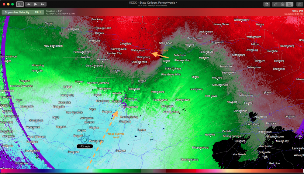
Screaming southerly winds showing on velocity near the 850mb level, >60knots showing up. Basically the reason why this has WAA aloft and associated mixed precip driving further and further north has been so robust. With the lowest 0.5º tilt you can make out the general wind direction near the radar site as well, which is out of the ESE. That easterly component at the surface is going to keep temps from going much of anywhere.