MAG5035
-
Posts
6,078 -
Joined
-
Last visited
Content Type
Profiles
Blogs
Forums
American Weather
Media Demo
Store
Gallery
Everything posted by MAG5035
-
0z NAM starting… gonna be the most important model run of our lives coming haha. I need to nail down how thick the cirrus deck is gonna be here tomorrow.
-
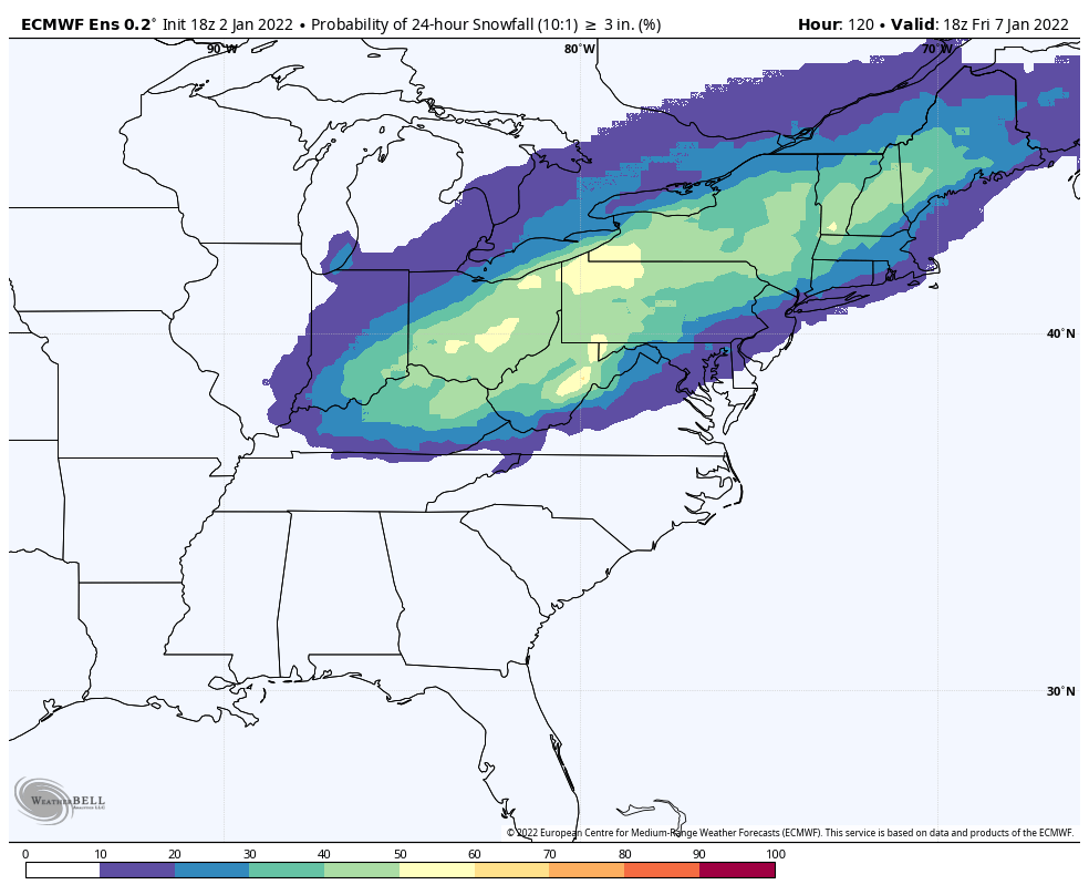
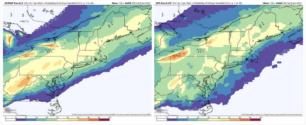
18z Euro ensemble >3” probs for the 1/7 storm. >1+ was more than 50% for pretty much our whole subforum. Still shows a bit of a focus toward the northwestern half of the state.

-
Yea dry air is definitely an inhibitor in this boundary type setup with the cold pressing. Otherwise if the low does in fact track to VA Beach like the GFS especially has suggested, that still is typically an okay track for the southern half of the area (Delmarva is ideal for C-PA). I feel some accumulating snow would find a way just across the M/D if it did that. A lot of the short/near term guidance take the low pressure off at the OBX, which probably would result in accumulating staying below the M/D line.
-
Haha that partial post above the post with the snow map… I see two trends in that screen capture lol.
-
Speaking of short/near term models. Here’s the 12z HREF for posterity. I know CTP utilizes it and pretty sure it was mentioned in the AFD this morning (not being much help at the time). It seems pretty clear across the model spectrum at this point that 8-12” or so is a pretty good possibility in the axis of heaviest snow. Gonna be important to keep an eye on surface low track. This model put this swath out with a surface low track hitting the coast at the OBX near Hatteras. GFS was a VA Beach track and Euro was pretty close to that too…big difference for the southern tier of our subforum.
-
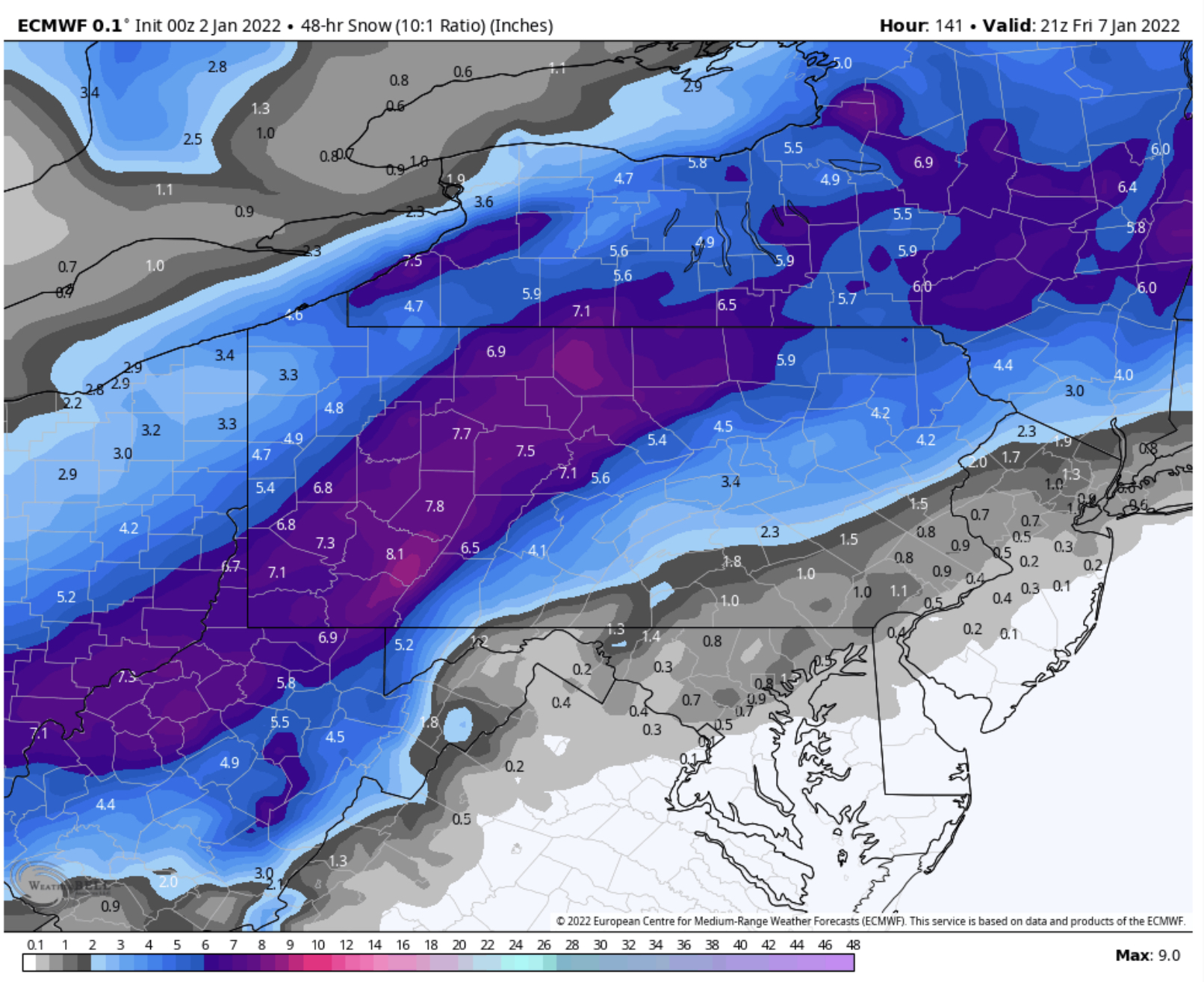
Yea this Euro run is a snow bomb. I know everyone likes to be nit picky and be like cut the snowfall amounts in half and ground temps and blah blah blah but none of that matters the first week of January (or April) with rates like that. DC has like 8 hours of 1”+ an hour and that’s applying 10:1. The column becomes cold during this with -6 to -8ºC all the way down to 925mb. This probably becomes greater than 10:1, hence why I’m presenting the Kuchera while I try not to shed a tear. That would get the 6” line into York and Lancaster.
-
That late week system has looked good on everything that goes out that far and their ensembles not named the GFS op the last few runs, though the GEFS has looked like it’s started to support GFS op some with 6 and 12z today lessening it’s snow/QPF mean. Don’t really think fast flow is the issue, I mean this thing coming up tomorrow is in the same fast flow regime. It looks like GFS may be deeper with the mid-week feature over the Great Lakes that reinforces our cold and possibly sets the table for that event (something I mentioned was probably going to be a key for that late week threat). Also might be somewhat faster with the shortwave that would cause the 1/7 event. So could be why that particular model has been squashing it.
-
Hardly, unless you only looked at the GFS op tonight. New Euro’s coming in a bit high and tight for the LSV’s liking this run and best snowbands in western/central PA. This is very much still in play. I used 10:1 for that. The Kuchera makes that 6”+ swath a 10”+ one.. which is possible because the snowy side of that system is likely to have a cold column and good surface temps.

-
Track about the same on the 0z vs 18z Euro. Precip extent does sneak across the M/D line on the 0z getting an inch or so into southern York/Lancaster. Best snowfall axis about the same but big difference in top end with a more GFS-like 10”+ swath now (not as expansive as the GFS though).
-
The GFS has been pretty inconsistent with it the last model cycle or so. Going a little further back to yesterday’s 12z run, it was a full blown lakes cutter. The GEFS has shown it more consistently. The 0z still has a 2”+ mean over most of PA despite the complete miss on the op. 0z Canadian’s coming in with a nice 4-8” type snowfall statewide. The earlier 18z Euro ensemble that goes out to 144 and saw most of the event also was in good shape for a widespread snowfall. Still a medium range deal so I think it’s still looking good all things considered.
-
Progressive pattern was my big thing with this feature and it still is but I was not expecting the shortwave responsible for this to get stronger like it has. I expected a much less defined one in the wake of the current wave. There’s probably a cap at how far up this can get but I’ll eat the humble pie if the LSV does end up with a decent event. I already accepted sitting this one out in the cold in hopes of the 1/7 event after literally having it rain off an on the entire 6 days since it snowed Monday. But I’m still a snow weenie at heart too so this 1/3 one’s probably gonna reel me in just enough to hoping to see it get something up this way haha.
-
18z Euro v. 12z Euro, a jog north on extent with accumulating (1 inch or so into DC now) but fairly similar with amounts/heavy axis placement.
-
I mean swath-wise with the axis of heaviest snowfall is certainly a hat-tip toward the GFS when considering what the Euro/Canadian has. The 12z Canadian indicated a lot of heavy sleet where the heavy deform bands presumably would be in central/eastern VA. GFS still NW with it’s axis vs those two and very heavy with snowfall and the 18z GEFS largely backs it up it appears. The Euro/Canadian take is still a pretty big snowstorm for that area but 18z GFS evolution is a big ticket snowstorm for the Mid-Atlantic region. 12 and 18z NAM today has been straight up uninterested in any of this which I’d imagine is probably wrong to at least some degree considering the rest of the guidance suite and associated ensembles and the fairly robust shortwave in question even with limited amplification opportunities. So at any rate, obviously the middle of the road is the best way to approach this as there’s a lot of questions to resolve. If this indeed ends up a deeper wave and puts good precip into the Mid-Atlantic region, big question probably is going to be if there’s gonna be a changeover to overcome and how long it takes where biggest snow totals are being presented, which comes down to timing and how well the cold actually progresses. LSV shouldn’t have that problem by that time, but northern extent is now the big question for some in this subforum. I still say I don’t expect a lot if it does make it into the southern tier LSV, but we shall see. I’ve often looked at them but it is important to still pay attention to QPF maps, especially in fringe situations like the LSV is going to be possibly be positioned in for this 1/3 event.
-
Boy we’re really about to find out about the GFS’s short term prowess these days with a snowstorm on the line, especially the folks in Central VA. In the meantime the NAM should sue the GFS for copyright infringement of the term “NAM’ed”.
-
I wasn’t overly optimistic on the 1/3 system a few days ago and I still am not, though I’ll admit the door is open for our fringe folks on the southern tier to maybe get a period some light snow. It’s a nice vort on the 500mb but patterns quite progressive for this and there’s no interaction at all with the northern stream. I think this wave needed to come up faster on the heels of what we’re getting today for this to have had a chance at working well for our region, which would have required some thread the needle timing with the cold air coming in tomorrow. I have much higher optimism on this 1/7 event. Key feature for this appears the low that traverses the Lakes mid-week and refreshes the cold… setting the boundary this wave will run. Additionally, this feature may help lessen or take away the potential for this to cut. Seems like the GFS and Canadian ops today really press the cold after the mid week low and stuff the wave that potentially becomes our snowstorm (Canadian especially.. GFS wasn’t really that far off). 12z Euro sets it up perfect. 12z Euro and GFS ensembles as a mean seem to be angling more towards what the Euro op is showing. Ensemble comparison: Prob of 24 hr snowfall >1” Euro EPS v. GEFS
-
0z Euro is looking pretty good for pretty much everyone with the 1/7 wave. Ramps up especially in eastern PA but a nice event for everyone in western/central PA.
-
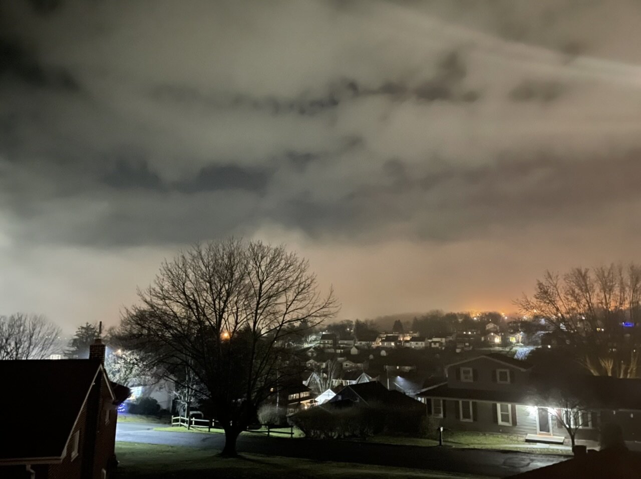
Some hard hitting obs, it’s foggy out. It’s been this way off and on most of the last 24 hours with temps in the mid 40s (44ºF currently).


-
Yea trends on the models have been consistently showing a transition to a +NAO/AO going forward. For us to have a longer lasting period of cold/snow opportunities later in January, this is where we need some ridging out west to build in the PNA realm to go with the persistent Pac ridging (-WPO). Looking at today’s ensembles, Euro EPS and GEFS both transition towards a western ridge look but differ a good bit in alignment. GEFS vs Euro EPS 500mb anomaly (Day 10-15 average) The GEFS has a really good look, with the ridge bridging over to Siberia. This alignment would suggest a more direct cold air source, even with the +AO look. Basically pretty chilly but not overwhelming. The Euro has troughing in AK.. cutting off that Siberian source and flattening/broadening the western ridge, and generally making for a warmer look in the east. Here’s the comparison with the 5 day average 850 temp anomalies (D10-15 average) The Euro still isn’t super torchy in our region, but you can see how much more favorable the GEFS would be when considering storm track.
-
Yea it looks to be modeled as a very robust shortwave that’s pulling an arctic front. We can debate how long the significant cold shot behind it lasts but it looks like a pretty significant blast with -15 to -20ºC 850 air briefly overspreading the commonwealth If we had a big time ridge established out west for this we might have been making comparisons to some other arctic wave that happened on 1/6-7 a few years back.
-
Yea that 12z Euro threw down a 12”+ swath (1-2 feet factoring Kuchera) on a rapidly developing wave running an arctic boundary from the Lower Lakes through upstate NY/interior Northeast. *Yawn* That swath was right through PA just on the 0z run, and this particular wave is on all the models today. Not super far out in range so the strong storm signal amongst models is noteworthy, but definitely too far out to make any assumptions.
-
Yea I agree with you. We started the month out pretty chilly and weren’t super warm but somewhat above average highs for most of it, with those dry chilly nights kind of counter balancing some. Up until this week we have been in a really dry pattern since November. Big thing is we have had zero legitimate winter cold shots (even something more mundane like 20s for highs) and that’s really weighing into that temperature average. That and of course the last few days to close out the year are definitely going to be significantly above average day and night. Take Dec 98 for example, that year got to #2 way differently with the front half of that month way above average and most of the first week of the month in the mid 70s+ for highs (one day cracked 80) at MDT. I remember it well.. I was 12 and it was my first deer season hunting. I’ve had some warm hunts in recent years but there still isn’t anything that compared to the opening day of rifle season that year.
-
Gulf of Alaska Tropics > Susquehanna Valley Tropics Bubbler definitely would’ve been running the AC in Kodiak, AK yesterday lol. https://www.reuters.com/markets/commodities/baked-alaska-record-december-warmth-winter-rains-2021-12-29/
-
JB finally acknowledging this a bit more in a post today. Regarding the MJO I’ve brought this correlation thing up like twice in posts the last few weeks, which is why I continue to think we need to get it to 8 and 1, and there are signs of that maybe finally occurring. Interesting tidbit with the NOAA quote, something I’ve admittedly not really thought about but it’s interesting to consider… the La Niña enhancing the Phase 7 pattern. Look at what’s happened in the west (esp the Sierra Nevada of California). The big concern there leading into winter with the ENSO being a Nina was continued drought conditions especially in that part of the west and about the most opposite thing that could probably occur has happened. But yea models have been all over this super -PNA all month, I mentioned previously that getting into the territory it has gotten into was probably going to be a primary driver over the -NAO/AO and it was going to have to neutralize at least some. It shouldn’t be a surprise that we ended up where we are currently at going through this month on this side of the country.
-
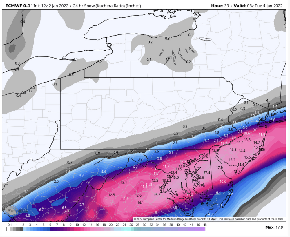
Did it rain or sleet at all before you were able to bring the snow sample in yesterday? That might’ve lowered the SLR some. Either way it may have been a low ratio event. I didn’t melt mine down but it seemed pretty moisture laden and the majority of the 2-3” around here fell in about 2 hours or so in one intense period of precip. One thing I noticed the night before when I was looking at the guidance to gauge the likelihood of this snow burst was the column of course was marginal.. but even at 700mb it was only a couple degrees below zero which is roasting at that particular level. That’s getting into the typical region of snow growth and only -1 to -2ºC would yield poor snow growth and likely a high moisture content. So ratios were probably pretty lousy, I dunno about 5:1 ish lousy but it’s possible.
-
Hey I basically told you the same thing without the cover charge lol