MAG5035
-
Posts
6,078 -
Joined
-
Last visited
Content Type
Profiles
Blogs
Forums
American Weather
Media Demo
Store
Gallery
Everything posted by MAG5035
-
Central PA - Winter 2020/2021 Part 2
MAG5035 replied to MAG5035's topic in Upstate New York/Pennsylvania
Right at 3" with snow lightened up. -
Central PA - Winter 2020/2021 Part 2
MAG5035 replied to MAG5035's topic in Upstate New York/Pennsylvania
Yea even though this still looks mixy you can see tonight's run gets the low to the coast under us and with that banana high to the north it def favors deeper cold and a more frozen outcome. -
Central PA - Winter 2020/2021 Part 2
MAG5035 replied to MAG5035's topic in Upstate New York/Pennsylvania
It's been crushing pretty good for a little while though starting to get on the edge of the best stuff. Glance at the snowboard out in the yard from inside using binoculars with the lights on looks like almost 3". How much back building happens is likely going to determine if I can get into the 4-6" forecasted range. -
Central PA - Winter 2020/2021 Part 2
MAG5035 replied to MAG5035's topic in Upstate New York/Pennsylvania
This is the type of enhanced stuff the next few hours that's either going to get us to our forecast totals or not, which should eventually push into the LSV. It's coming down pretty heavily now here.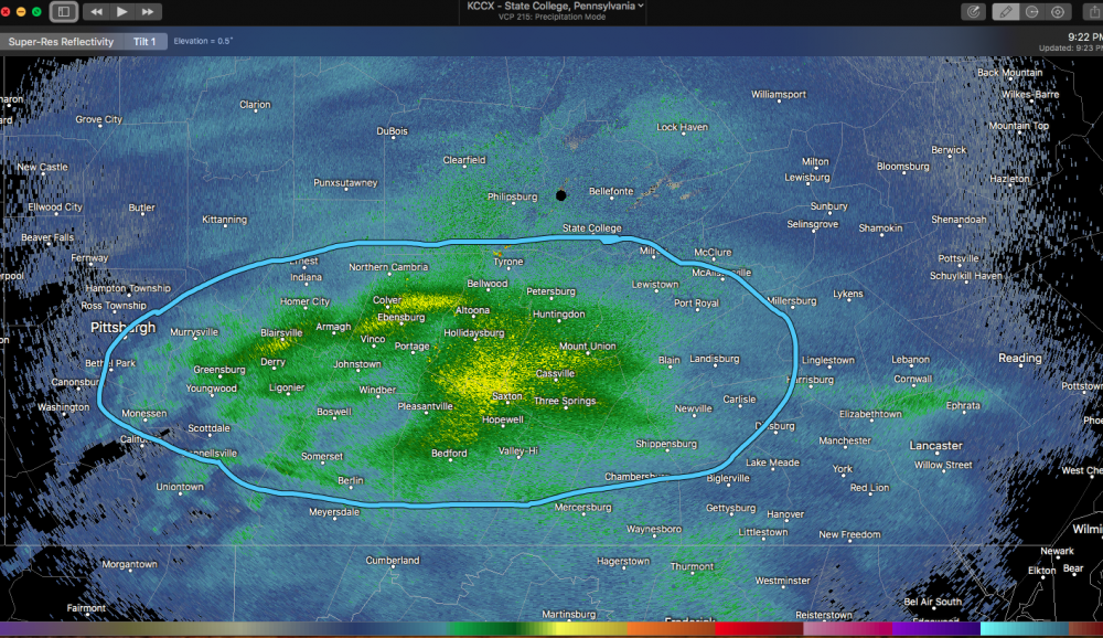
-
Central PA - Winter 2020/2021 Part 2
MAG5035 replied to MAG5035's topic in Upstate New York/Pennsylvania
Yep Radarscope. -
Central PA - Winter 2020/2021 Part 2
MAG5035 replied to MAG5035's topic in Upstate New York/Pennsylvania
Starting to see the bigger flake size with the enhancement showing on radar.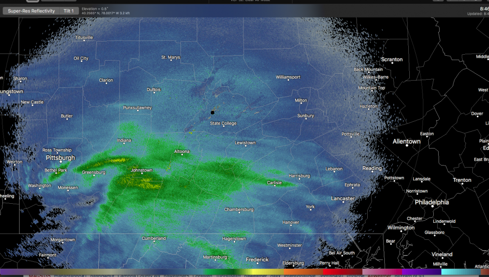
-
Central PA - Winter 2020/2021 Part 2
MAG5035 replied to MAG5035's topic in Upstate New York/Pennsylvania
Got moderate snow and getting pretty close to an inch so far. Temps back to 25ºF -
Central PA - Winter 2020/2021 Part 2
MAG5035 replied to MAG5035's topic in Upstate New York/Pennsylvania
Steady light snow now, pretty grainy. 29ºF -
Central PA - Winter 2020/2021 Part 2
MAG5035 replied to MAG5035's topic in Upstate New York/Pennsylvania
Some light snow starting, temps around freezing. -
Central PA - Winter 2020/2021 Part 2
MAG5035 replied to MAG5035's topic in Upstate New York/Pennsylvania
I think CTP may be considering that route for some of the southern tier counties. They did have a brief short term update early this afternoon addressing having to bump up for more QPF and higher ratios and most likely for warning upgrades were the Laurel's counties Cambria and especially Somerset. Def concur with that as the most likely area for more widespread 6+ in the CTP CWA would be those two counties.. where the best overall QPF and high elevations conincide. There's definitely some support on the short term guidance for that and perhaps Bedford/Fulton/Franklin/Adams as well, IMO. Franklin and Adams need 5" in 12hr for a warning criteria so it's certainly in the realm of possibility. -
Central PA - Winter 2020/2021 Part 2
MAG5035 replied to MAG5035's topic in Upstate New York/Pennsylvania
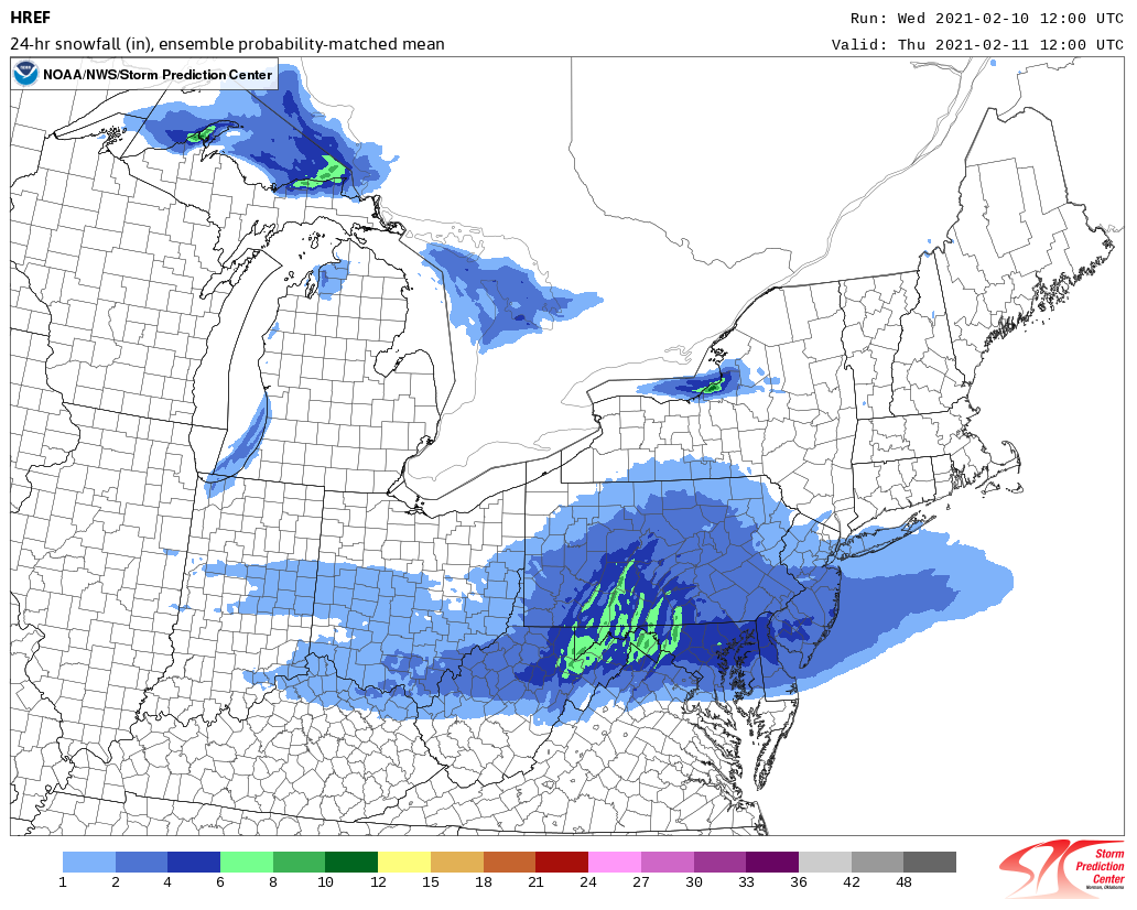
12z HREF guidance.. regular mean and probability matched mean.
-
Central PA - Winter 2020/2021 Part 2
MAG5035 replied to MAG5035's topic in Upstate New York/Pennsylvania
No biggie, your concerns were definitely valid. You can see today looking at temps across the state how we don't have any actual arctic air or at least extremely dry air in the state and that it does appear the boundary where the icing is occurring in the Ohio Valley looks to be setting up a bit NW with this first wave. This type of gradient stuff doesn't get usually resolved until we're in the short/near term. Still gotta get the snow on the ground too lol. -
Central PA - Winter 2020/2021 Part 2
MAG5035 replied to MAG5035's topic in Upstate New York/Pennsylvania
It seems like more focus is put on this initial wave tonight over the second one Friday and that "round 2" looks more like the feature we see showing Sunday. By the way I'm shocked where guidance has ended up with tonight's wave, SHOCKED I tell ya lol. This thing currently pegged for next Tuesday looks like a pretty significant storm. We have the GFS and Euro trying to cut it today. In the case of the Euro, trying to cut into a 1040 high that starts at hr 138 sitting on the Canadian shore of Lake Ontario. I'm not sure why it's such a freezing rain bomb given the thermals. Hr 150 which caps the height of a 6 hr period of significant precip (mostly ZR), has marginal 700 and 850 temps (still at or just below zero) and majority of 925 and 2m temps in the teens to low 20s. In other words, probably a sleet/snow bomb. Honestly like the Canadian's evolution here as general theme is a bigger storm attacking solid high pressure to the north. Speaking of themes, there have been a lot of attempts at cutting in this D6-8+ timeframe this winter. That's where the Jan 31-Feb 2 storm started. -
Central PA - Winter 2020/2021 Part 2
MAG5035 replied to MAG5035's topic in Upstate New York/Pennsylvania
Yea I saw that a bit ago, it's a pretty bullish forecast dependent on that second surge Thurs night/Friday. This first wave tomorrow night has been showing back up better on guidance well into PA the last couple runs while second wave has seemed to stay more below the mason-dixon. Still like bottom two tiers of PA counties having a solid advisory type snow for tomorrow night's wave. Even if Friday misses, that next potential event is already almost in NAM range on Sunday and then looking like something Tuesday (0z GFS was big for that one). -
Central PA - Winter 2020/2021 Part 2
MAG5035 replied to MAG5035's topic in Upstate New York/Pennsylvania
They sure aren't. My uncle lives there and he went through the 2009 ice storm. This pic isn't his but he lived a couple miles from the NWS there at the time and this was taken from the office. Pic Source: https://www.weather.gov/media/pah/Top10Events/2009/Ice Storm Jan 26-28 2009.pdf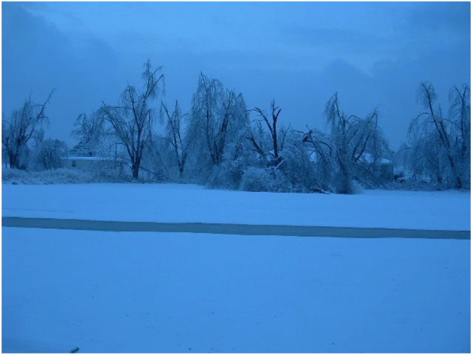
-
Central PA - Winter 2020/2021 Part 2
MAG5035 replied to MAG5035's topic in Upstate New York/Pennsylvania
Man those TT maps that combine all the frozen/freezing precip make me cringe haha. I bet those folks in eastern KY wish they were actually getting 16" of snow.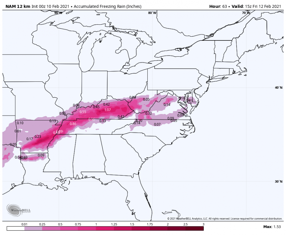
-
Central PA - Winter 2020/2021 Part 2
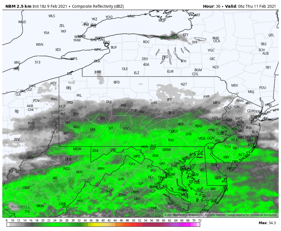
MAG5035 replied to MAG5035's topic in Upstate New York/Pennsylvania
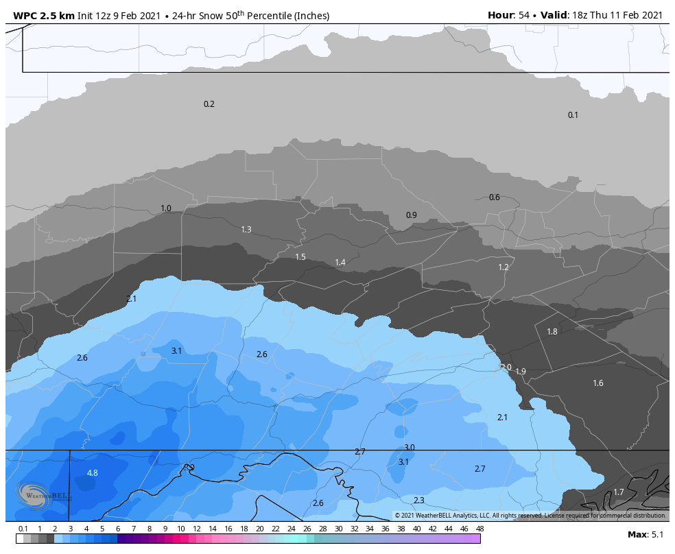
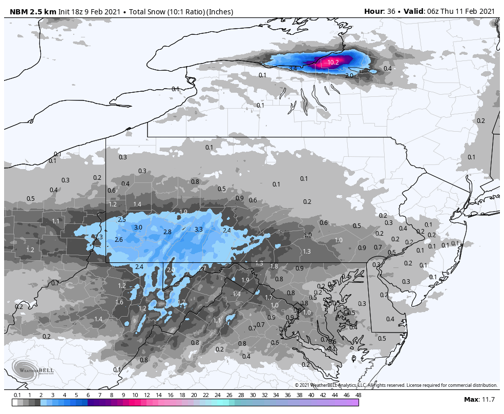
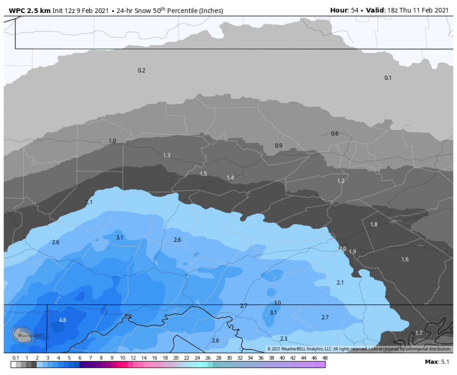
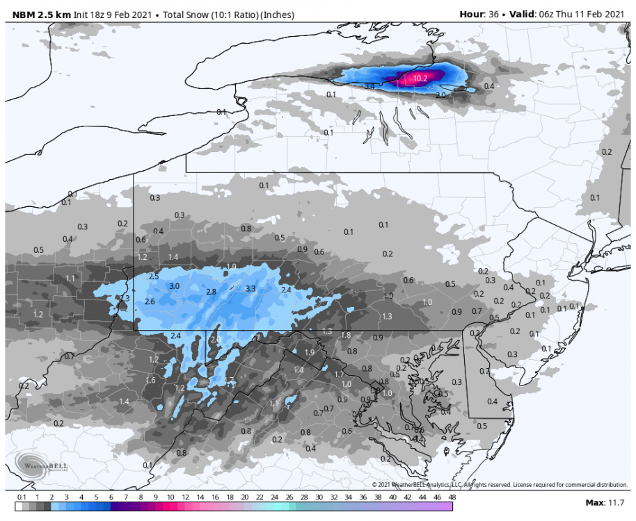
Some other short range model guidance data to consider. 18z NBM (National Blend of Models). Only goes to 36hr on WB and is still mid event at the end: 18z WPC guidance 50th percentile 24hr snowfall, aka CTP's current expected snowfall: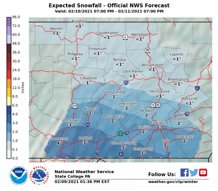
-
Central PA - Winter 2020/2021 Part 2
MAG5035 replied to MAG5035's topic in Upstate New York/Pennsylvania
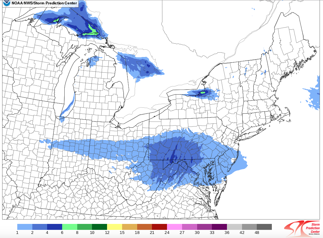
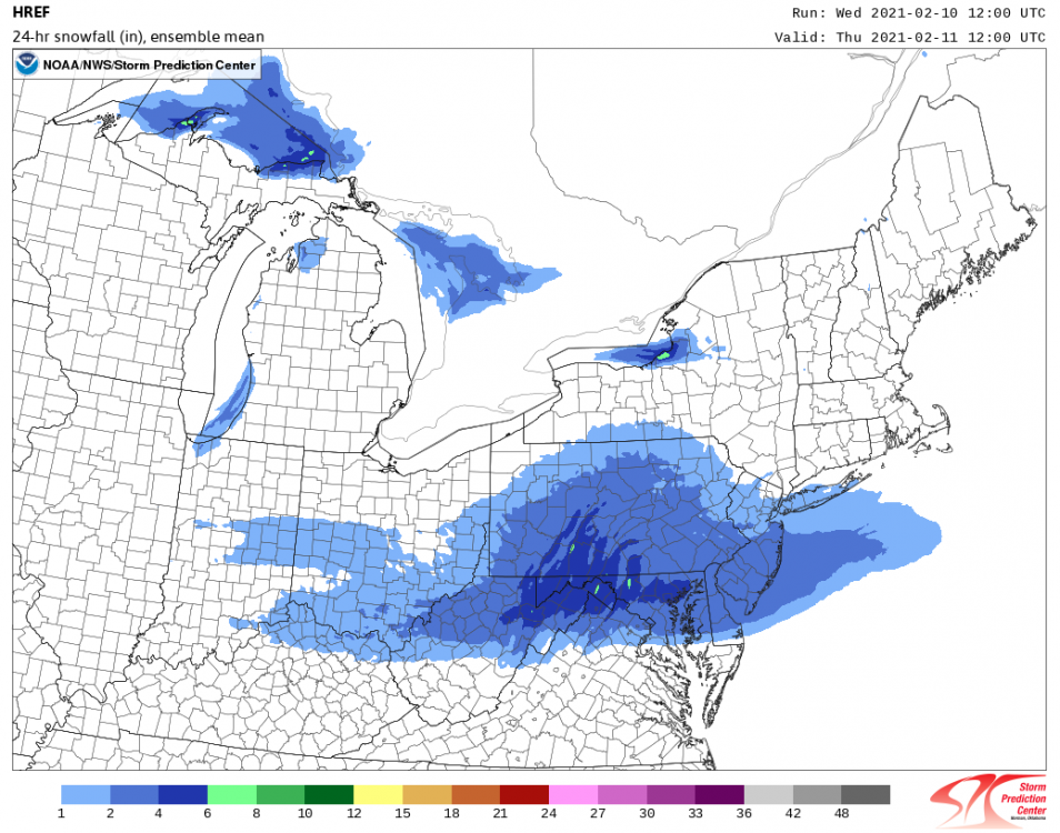
SPC's 12z HREF guidance (24hr mean snowfall at 48hr). Only goes out to 48hrs so probably isn't covering the entire first wave in eastern PA.
-
Central PA - Winter 2020/2021 Part 2
MAG5035 replied to MAG5035's topic in Upstate New York/Pennsylvania
This above post was from back on Saturday. I've been saying the last few days that this week isn't about getting the big storm...as we don't have the amplification in the pattern for it (late weekend into next week appears like that could be another story). We have a gradient pattern with overrunning waves running the gradient and the key was to locate where these swaths were going to go. Things have trended south the last few days, favoring the northern Mid-Atlantic region with best snows but still a good chance of a half decent snowfall south of I-80 and I'm not going to rule out some snow north of I-80 yet. Still looks like a two pronged event, with a surge of precip tomorrow night into Thurs and then late Thurs night into Fri. Just a matter of how far north we can get this overrunning precip. To me this still looks like a good chance of a solid advisory event for the southern two tiers of counties in PA as is with best chances of 6"+ residing in the western MD counties and potentially getting up into the Laurel's counties on the southern tier. One fortunate thing about this trending south as it took the icing swath south, which was one of my concerns outlined on that post over the weekend and that definitely looks like that's coming to fruition. Most of those winter storm watches running the Ohio River across KY into WV are ice related or some kind of snow/ice combo. -
Central PA - Winter 2020/2021 Part 2
MAG5035 replied to MAG5035's topic in Upstate New York/Pennsylvania
0.8" was the total here this morning. Looked like downsloping killed things here as those nice totals and rates over in SW PA def didn't translate over the Laurel's very well locally. -
Central PA - Winter 2020/2021 Part 2
MAG5035 replied to MAG5035's topic in Upstate New York/Pennsylvania
Yea same, looks like I have about an inch at best. I think some downsloping probably isn't helping my cause here. Def a good event over in western PA, looks like a solid 3-5" over in Pittsburgh. -
Central PA - Winter 2020/2021 Part 2
MAG5035 replied to MAG5035's topic in Upstate New York/Pennsylvania
Hard to say yet. Comparing where this seems to be setting up in western PA on radar vs what the 0z 3k and 12k NAM have.. it does appear it's coming in lower. So we'll see how that translates across the state. Some of this might get as low as the turnpike in the Sus Valley but the best probably still goes north of MDT. -
Central PA - Winter 2020/2021 Part 2
MAG5035 replied to MAG5035's topic in Upstate New York/Pennsylvania
Yea I'd say. The 511 cams around the city look pretty snowy already. Flurries just starting here and 23ºF. -
Central PA - Winter 2020/2021 Part 2
MAG5035 replied to MAG5035's topic in Upstate New York/Pennsylvania
Should be seeing snow start here within the next hour or two by looks of the radar. Hoping that this precip swath finds it's way a tad south of where the 0z short range guidance like the NAM takes it. Could be a fluff bomb for whoever gets the best rates. -
Central PA - Winter 2020/2021 Part 2
MAG5035 replied to MAG5035's topic in Upstate New York/Pennsylvania
I know JB has been musing on some of his posts lately about this current Feb pattern looking like Feb '94, which was a gradient pattern not all that dissimilar to what we're looking at right now. Feb '94 ( as well as Jan during the major arctic air intrusions) was a neutral at best but generally positive NAO/AO. I'd imagine his angle in having this similar gradient pattern with the established -NAO in place is that the waves running the gradient would target the DC region/Mid Atlantic more favorably than 1994 did. 93/94 was either the snowiest or 2nd snowiest on record in places like UNV/IPT/MDT but a lot of those events (esp in Feb) were primarily ice down there and also in the southern LSV too.