MAG5035
-
Posts
6,078 -
Joined
-
Last visited
Content Type
Profiles
Blogs
Forums
American Weather
Media Demo
Store
Gallery
Everything posted by MAG5035
-
Central PA - Jan 31 to Feb 2 Winter Storm
MAG5035 replied to MAG5035's topic in Upstate New York/Pennsylvania
When I made this storm thread I said western PA folks were welcome to post obs and discussion over here. With that said let's keep the posts useful and on topic. -
Central PA - Jan 31 to Feb 2 Winter Storm
MAG5035 replied to MAG5035's topic in Upstate New York/Pennsylvania
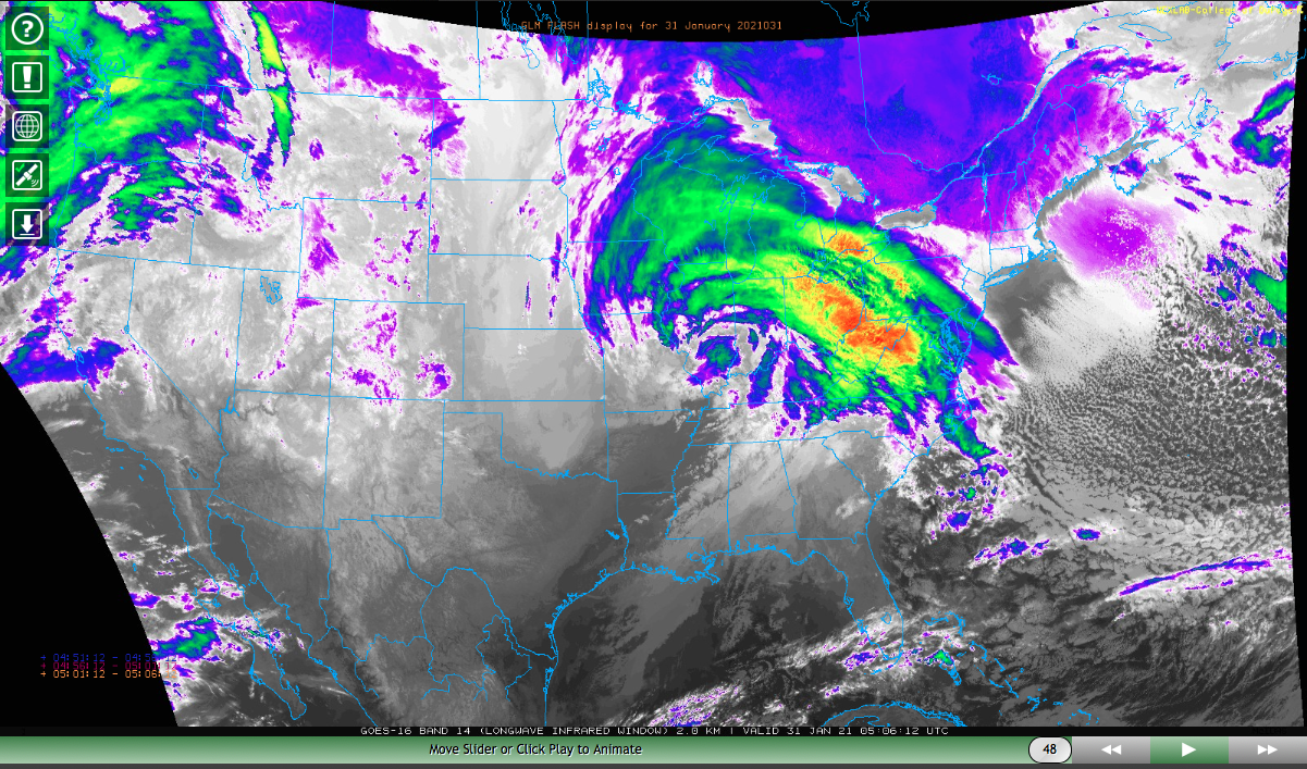
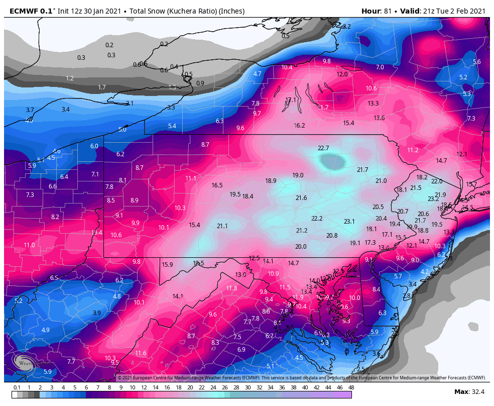
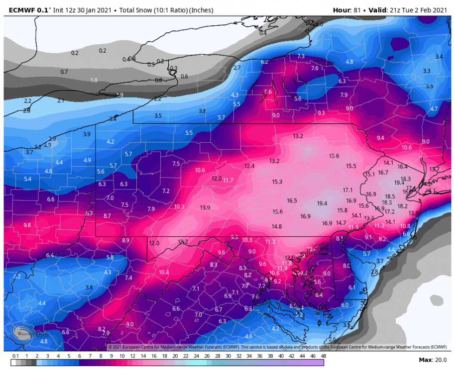
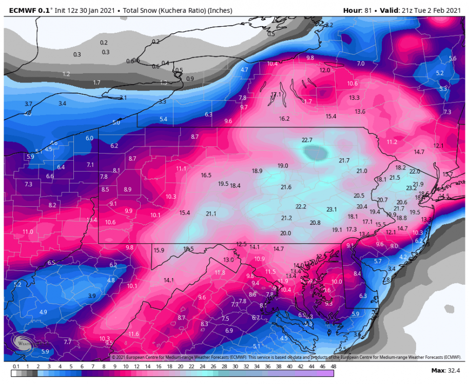
Another areawide Euro thrashing at 0z. I-81 corridor from Harrisburg to Scranton roughly being the bullseye, although most of eastern PA is 20"+ on Kuchera and Euro hasn't yet relinquished the snow completely all the way through hr 69. -
Central PA - Jan 31 to Feb 2 Winter Storm
MAG5035 replied to MAG5035's topic in Upstate New York/Pennsylvania
Lol, good luck over there too. Looks like Pittsburgh's going to be getting started within the next couple hours. -
Central PA - Jan 31 to Feb 2 Winter Storm
MAG5035 replied to MAG5035's topic in Upstate New York/Pennsylvania
Incoming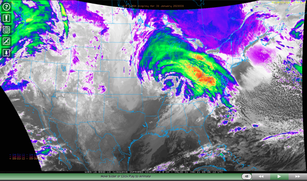
-
Central PA - Jan 31 to Feb 2 Winter Storm
MAG5035 replied to MAG5035's topic in Upstate New York/Pennsylvania
I don't know why we're all so feisty in here tonight. Here's the thing with some of these crazy amounts coming out of models like the RGEM. If someone in eastern PA sees 40-55" from this storm I'll buy everyone in here a beer lol. To me, nailing down this deform band late in the storm means trying to locate an area that sees perhaps up to two feet or so but likely more of a general 18-24" bullseye area. Other than that, this is within a zone where basically every regular in here including 2001kx and wmsptwx should easily see a warning event and I think this is mostly a 10-14+" swath for everyone under I-80 (and probably above it too eastern third to half of PA). We'll have to watch for the slot and perhaps a slight bit of mixing toward the MD border, but I don't think this kills totals all that much by the end if it happens. We should have snows flung back into PA for a good while even if we don't get the intense deform band in our area. -
Central PA - Jan 31 to Feb 2 Winter Storm
MAG5035 replied to MAG5035's topic in Upstate New York/Pennsylvania
26°F and calm. About to be a good bit more snow in the yard.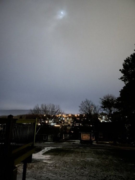
-
Central PA - Jan 31 to Feb 2 Winter Storm
MAG5035 replied to MAG5035's topic in Upstate New York/Pennsylvania
Hah maybe they forgot to change the units from cm to inches. Funny thing is that still would convert to 18-24" there, lol. -
Central PA - Jan 31 to Feb 2 Winter Storm
MAG5035 replied to MAG5035's topic in Upstate New York/Pennsylvania
15.4" on 1.2" precip" -
Central PA - Jan 31 to Feb 2 Winter Storm
MAG5035 replied to MAG5035's topic in Upstate New York/Pennsylvania
Yup, that's been the last 24 hrs in a nutshell watching guidance evolve with this lol. -
Central PA - Jan 31 to Feb 2 Winter Storm
MAG5035 replied to MAG5035's topic in Upstate New York/Pennsylvania
With a good snow column that doesn't have a warm nose in it and below freezing surface temps, it's more important what the temperature is where the best lift is occurring. Taking the Euro, temps are about -7ºC to -10ºC at 700mb where the big lift and heavy snowband is late in the storm. So not quite in the DGZ but it's definitely sufficient for good ratios. -
Central PA - Jan 31 to Feb 2 Winter Storm
MAG5035 replied to MAG5035's topic in Upstate New York/Pennsylvania
I can't take credit for the December storm haha, @pasnownut made that one. -
Central PA - Jan 31 to Feb 2 Winter Storm
MAG5035 replied to MAG5035's topic in Upstate New York/Pennsylvania
The early part of the storm where most of us spend likely the first several hours with a steady lighter snow probably won't have anything special in the ratio department... like an 11-12:1. Banding later in the event when the coastal starts cranking will be where we start seeing better ratios within heavier bands.. perhaps up to 15:1 or so. Euro generally had a 13-15:1 average going straight off of Kuchera amount divided by total QPF. Even the outlandish totals the RGEM have in the LSV are about a 12-13:1 average ratio with 15:1 out this way. -
It's time guys, I did the thing.
-
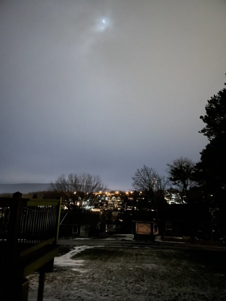
Well here we go, I'm kicking this off now so we can have some of our last minute model guidance discussion organized together with an overall storm thread. Plus we're about 12 hrs from this getting into the region. Western PA folks are welcome too if they want to share their obs/discussion. Current Obs: Clearish, 32ºF. Snowboard deployed
-
That might be the best the GFS has looked overall for our region with this storm.
-
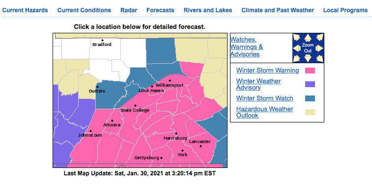
I retract my RGEM comment for now, I was looking at 12z. 18z hasn't ran yet. But still, a tremendous difference. This is why CTP is playing the slow but steady game with this.. although probably should've had the watches expanded more early today.
-
Yea, the 18z really lacked the organized intense CCB band that's going to be the determining factor for the eastern half of PA of having widespread excessive totals come to fruition or more like what the NWS is putting out with the 7-12" warnings. Still tremendous differences in the short range guidance. Check out the RGEM, the Mid-Atlantic folks probably fainted.
-
CTP also upgrading to warnings. Added some watches and there's a bunch of counties just got updated straight to warnings with no watches lol. Looks like all the warnings either 7-12 or 8-12".
-
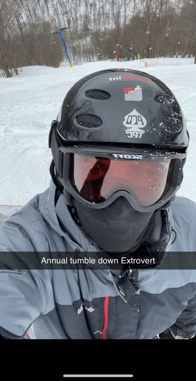
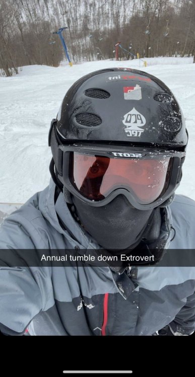
Lol I went up this past Sunday before we got the freezing rain. I’m surprised they haven’t been making more snow like they could but there’s a decent amount of regular snow up there. They have a lot of their diamond terrain opened with only natural cover, which is probably better than frozen machine made snow but there was some pretty thin cover in spots. I did survive the opened top half of Extrovert lol.
-
I'm definitely making a Blue Knob trip day after this storm ends.
-
Euro throttles most of the state. LSV slots briefly but then is ground zero for the eventual intense CCB band.
-
Lol, I think I'm going to "start a fresh thread" to "kick off the second half of winter".. but probably not until tonight at 0z.
-
I don't know if I ever saw such a big area of 40"+ on even the Canadian, which can put out some crazy stuff. The ratio isn't crazy either. Harrisburg gets 3.38" of QPF for a pretty reasonable 12:1 average through the event. Is that much QPF reasonable? I dunno about that yet. But still.. you can get to two feet pretty easily with 1.5-2" and good ratios.
-
@Voyager 4 foot bullseye. He may need to travel to ORD via a snowmobile.
-
This escalated rapidly. Up until yesterday there weren't very many model runs with the big totals.. with only really the Euro having that run or two with the 30"+ (down in VA/DC). Everything's coming back to slowing/stalling that low closer to the coast right in the zone we need it. Add in that tremendous easterly flow and warmer than average Atlantic and suddenly we're burying folks on all the models.