MAG5035
-
Posts
6,078 -
Joined
-
Last visited
Content Type
Profiles
Blogs
Forums
American Weather
Media Demo
Store
Gallery
Everything posted by MAG5035
-
It's like every time I thought I saw the craziest model runs ever leading up to a big storm in the last decade, the next big storm comes along with something crazier. This storm's starting in 24hrs or less guys.
-
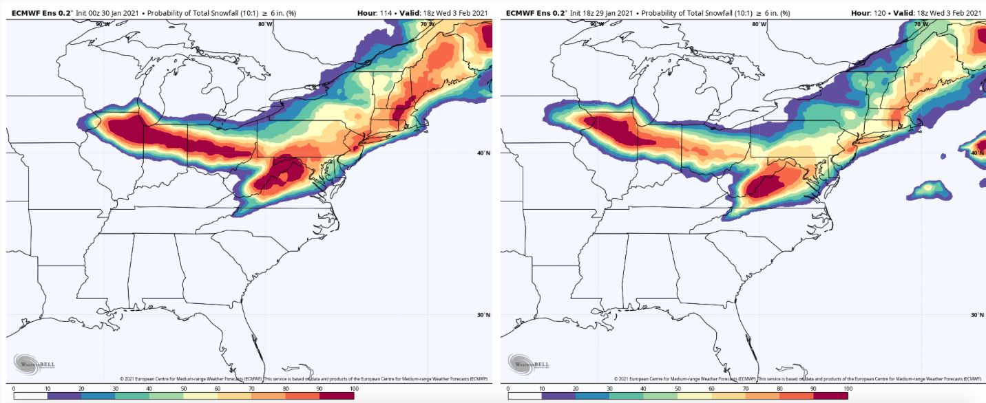
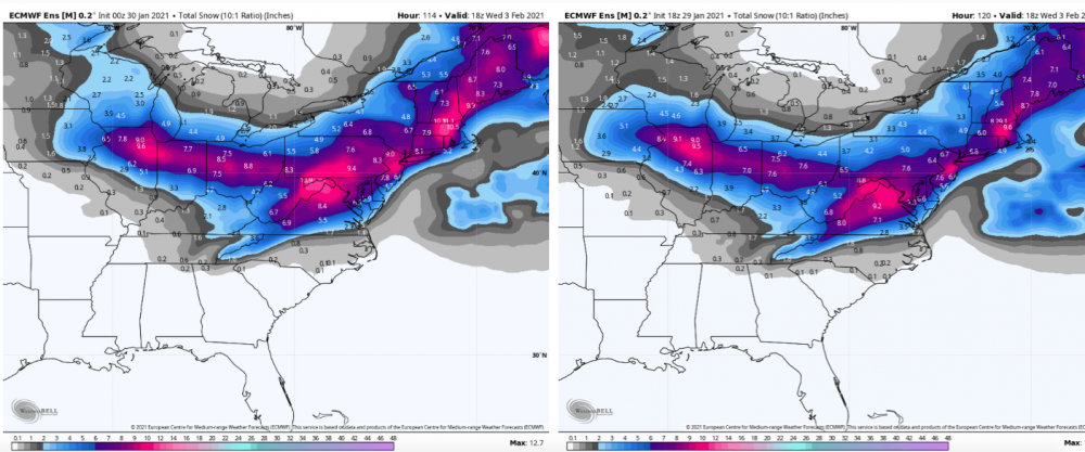
Euro ensemble with a nod toward the op. Pretty good jump from 18z.

-
Yea, this hasn't been standard boilerplate Nina though. Not with that dominant -NAO/AO blocking pattern. I don't even know how effective taking an analog approach really is when trying to compare to past Nina's because you really can't find one quite like how this one is shaking out so far...imo anyways. With the storm I actually commented a couple times about the swath, as in how often to you see a Chicago to DC heavy snow swath.. or even a Chicago to NYC one? You don't have the established blocking regime and a system that cracks Chicago with a big snowstorm is probably causing p-type issues at best in the Mid-Atl/NE. Which was why I took pause with yesterday being as far south with the swath as it was.. with last night's 0z Euro being the "low water mark" so to speak. I'm not an expert on Long Island climo but I'd think if that coastal stalls/meanders off the Jersey Shore south enough the damage is probably done before you ever mix. Yea it may come north further, but this has stronger blocking and prime dead of winter climo compared to the December storm. That heavy swath is gonna probably be somewhere south of that one, which should bode well for NYC because they did okay in December.
-
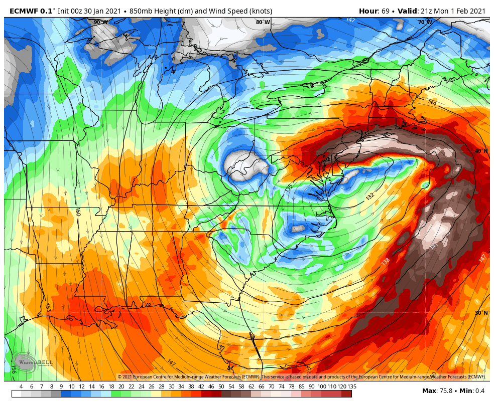
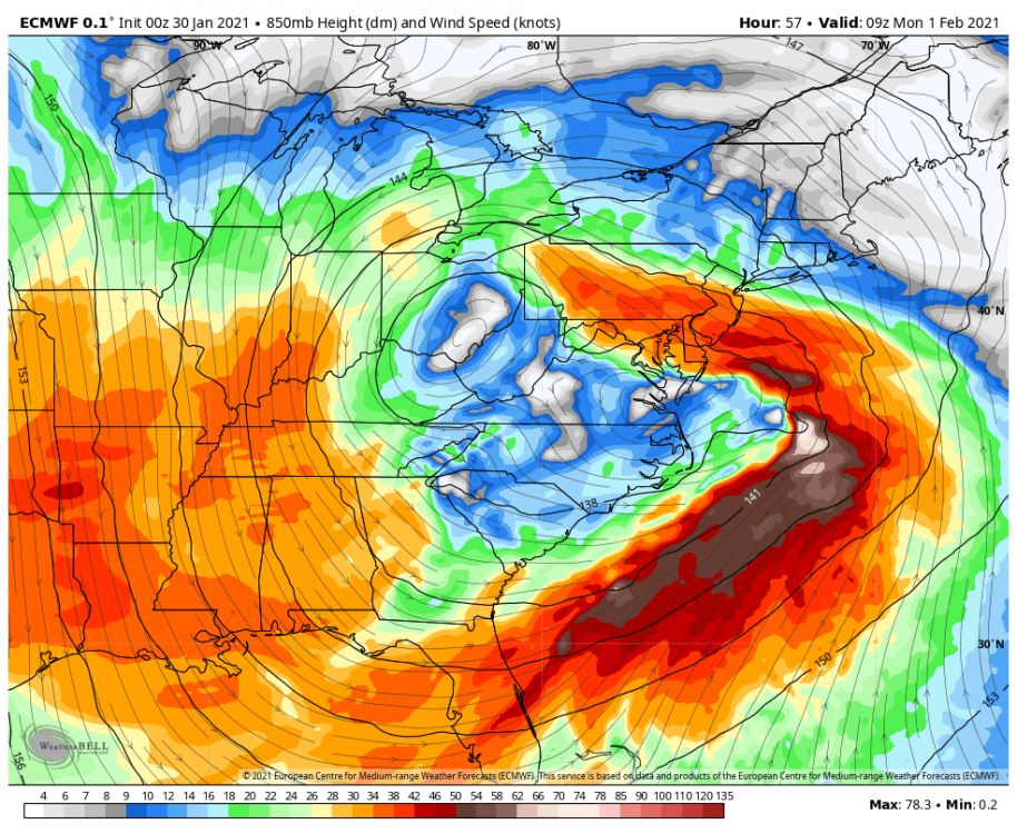
I think models are finally starting to fill in this precip shield between the transferring lows in realization of that major easterly fetch off the ocean between the system and the blocking pattern. The setup's just too good with that established 850mb primary low tracking just under PA and transferring. Look at the 850mb jet just nosed right through PA. Couldn't ask for much better placement of that 850mb low.

-
Yup I'm cashing that one out right now, lol.
-
Well no one's gettin 30-40"+ but it's a straight up butt kicking across the whole state.
-
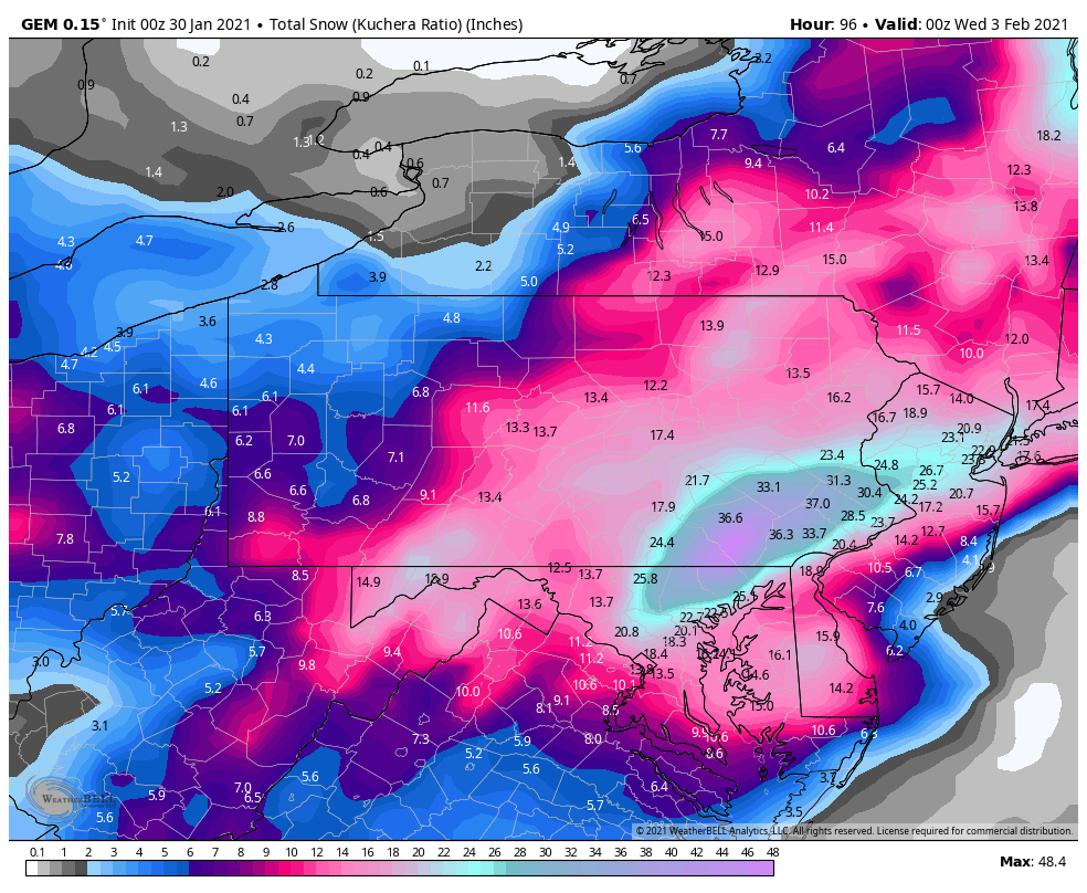
Euro's got a more expansive swath of heavier snows in most of the state so far through 57 hrs. Primary low presses right up to western WV with the transfer. Gonna be a pretty big one for everyone.
-
That part of the disco was updated at 9pm when only the NAM was starting to come out. I quoted it in one of my posts awhile ago.
-
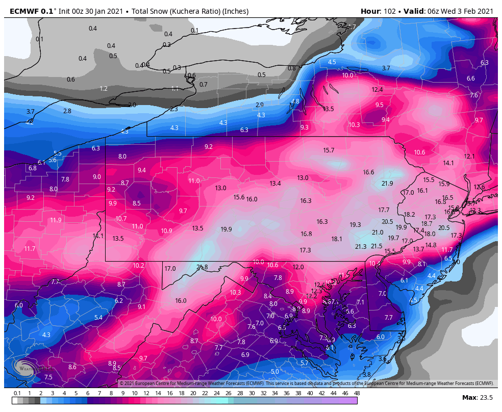
Wow, a sizeable part of Lancaster County is literally a 4 foot bullseye. Finally relents after about Hr 96.

-
Yep I just got there lol. Holy death band.
-
Careful with that TT and its snowmap counting snow/sleet together.. though I'm only at 60 with Weatherbell haha.
-
Well they can laugh but I'm starting to think that Subforum region is in the position the LSV was with the December storm. I mean that accumulation call I made earlier was a fairly safe preliminary call and I didn't bite on yesterday's model cycle dropping south either so I liked southern PA US-22 and south down to MD's I-70 corridor for the heavy swath. It's definitely looking like this heavy corridor is shifting north but like the LSV in the Dec storm, there was still a good event to be had before any mixing issues and I think the DC and north folks do fine. I said earlier that we def could see higher amounts than the 8-14 but probably less than 20"... and I'm sticking with that for now but I'm definitely watching what guidance is starting to do.. Models are starting to slow that coastal low down again which lengthens the time the deform hangs. They're also starting to solidify the precip shield.. which is something I expected given the anomalous 850mb easterly flow all the way into the Ohio Valley with the 850 low transferring just underneath PA. On CTP issuing watches for just the first tier of counties: Rolling with the ensemble guidance generally by the sounds of it, which is a good start considering op models are still in flux right now. If the Euro and ensembles start reflecting what the early stuff is putting forth tonight, they will likely be adding counties and perhaps more than slightly northward. One thing to consider for that I-80 corridor, if say the ensembles get like UNV and IPT into a 6" mean.. duration. It's likely they will be considering the 8" in 24 hrs over the 6" in 12hr criteria for a WSW. They may roll with an advisory even if the I-80 corridor sees 6" or so by the end. That's if the I-80 corridor doesn't end up in the thick of it too, lol.
-
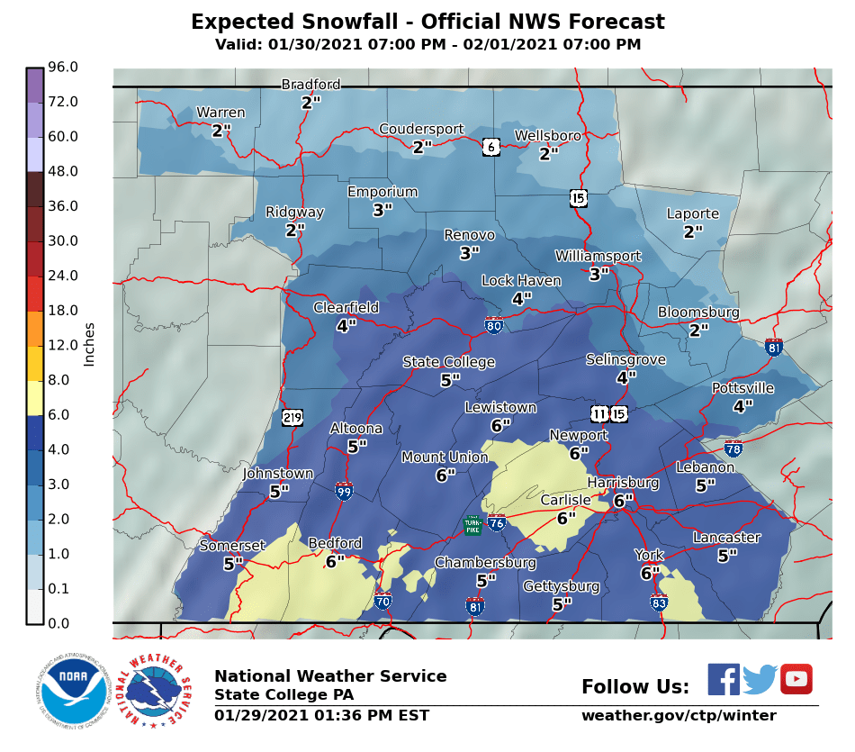
Guess he expects a uniform 8" in that zone haha, should either make the 8" a 6 inch line or bump up the low number of the 8-12". Oh well It's just the first guess map, although he had a map out yesterday so I suppose that one was the first guess on the first guess map.
-
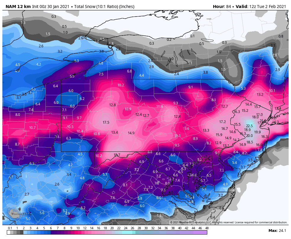
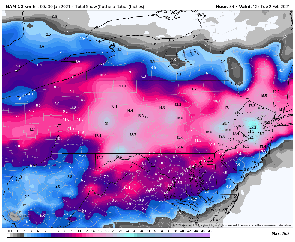
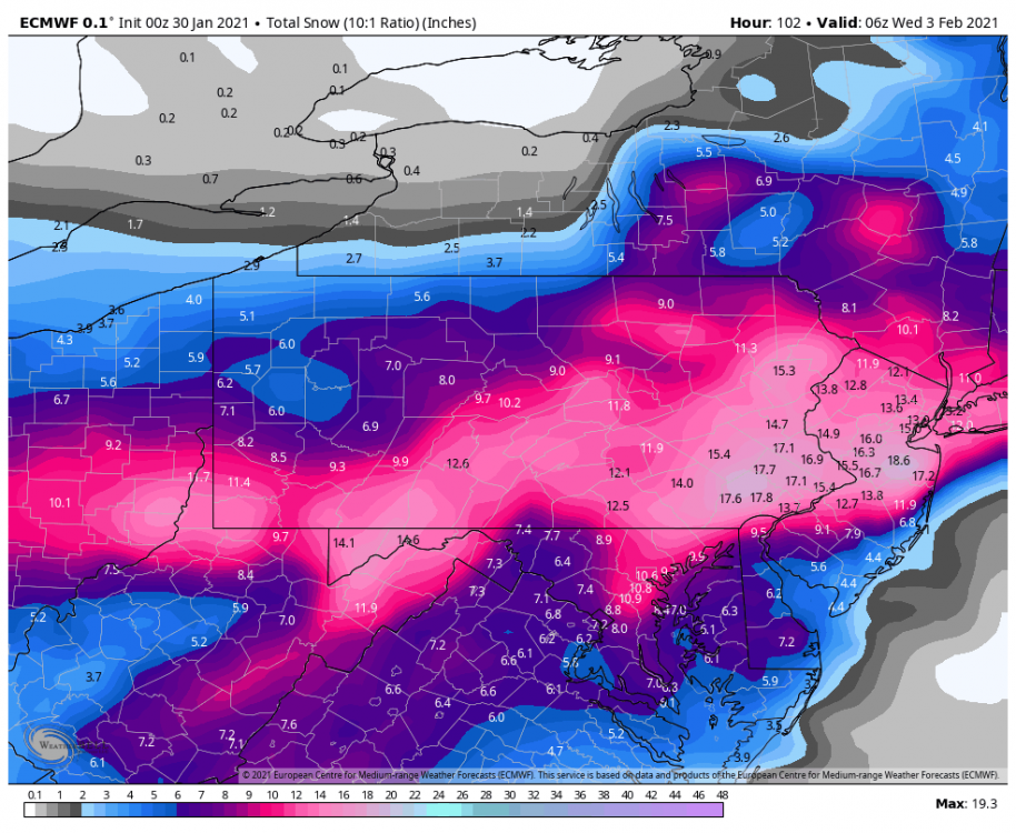
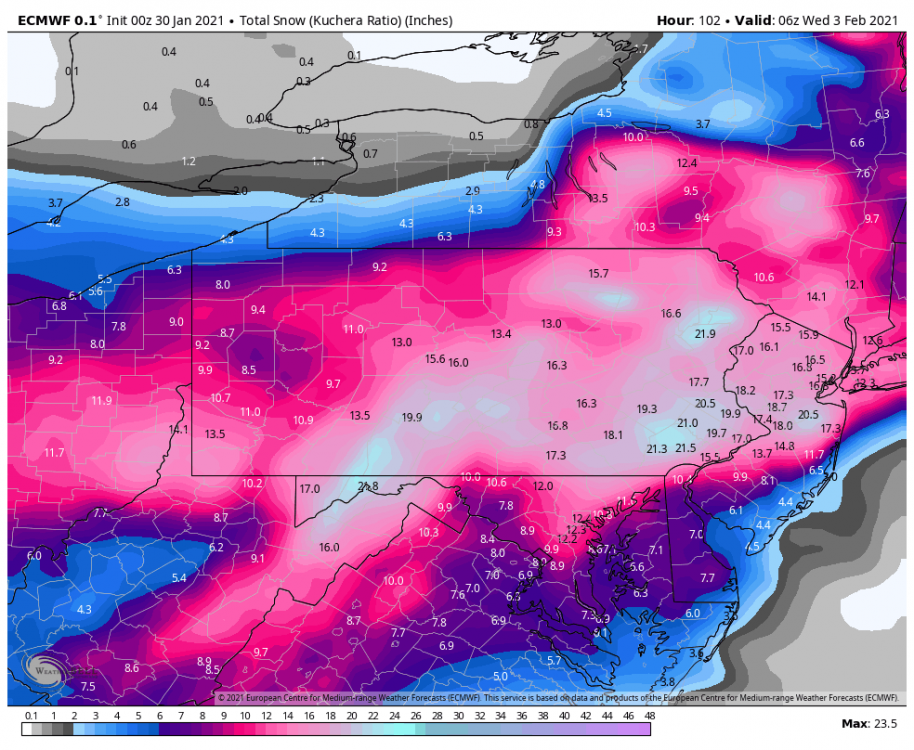
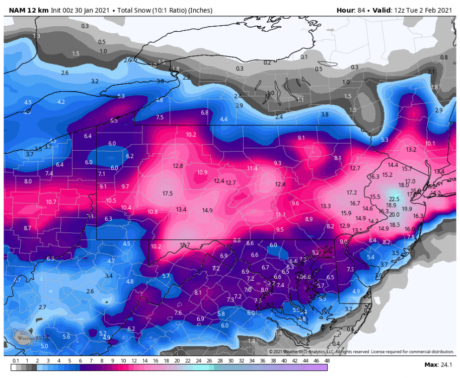
Still a huge run for everyone, the deform does get back into most of the Sus Valley late in the storm. Throwing up both 10:1 and Kuchera:

-
Considering where the coastal's at off the VA and Delmarva coast, it's really punching the mix into PA pretty far. It has a really intense 850 mb jet that looks like it advects in near to slightly above zero 850 temps in the LSV. 925mb and surface stay well below freezing. Would probably be mostly sleet. This looks like a classic really amped NAM run.
-
Well, okay getting some mix into the Sus Valley. Now we're looking NAM-y haha.
-
NAM's crushing through 51 so far, secondary low showing over VA beach. This is probably going to be pretty big.
-
Lol all the big ones from '96 on were mid-high teens storms here. 2003 may have done it between the storm and the upper level low passage the night after the storm ended but I never really measured that one. 2/5/10 I had like 17.5" I believe, but nearly 30" that week between that and 2/10/10. 2016 was close with those amounts being at the bottom of the county. I'd be happy with a second double digit storm for the season, that hasn't happened here since 2010.
-
I'm not sure which model your looking at but I only saw that effect on the 3k NAM this afternoon, which was showing some mixing in SW PA into the ridges. I do know it was showing up in previous runs and it's likely the easterly flow during the transfer causing a downslope effect on guidance on the west side of the Laurel's. Today's guidance is mostly showing better precip into PA from the primary today and a better precip shield overall so I don't think this potential effect would be too much of an issue as it's being presented currently... especially in southern PA where the best QPF is right now.
-
This just happened last month too. Model's putting the bullseye in the Sus Valley for the few days leading up. When the short term guidance morning of the storm was targeting places like State College and in between there to Harrisburg, I thought I might just see my first 20"+ storm since I was like 8 years old. And then the 20-40 inches ended up going from Clearfield- Williamsport-Binghamton while half the Sus Valley ended up mixing. Murgo slipped out a "s*it-load of snow" going over one of the short range model animations on his live forecast for that by the way lol.
-
I still remember the CTP forecast discussion like 2-3 days before the Feb 5-6 storm. Said something like "3 perhaps 4 inches along and south of the turnpike"
-
This is going to have a nice snowfall swath but I don't think this is going to have the high top end potential of the December system. With that said, we're getting pretty close to meso range and it's likely there's going to be some imbedded meso features in this precip shield that show up and probably bolster some totals. I'm liking a general 8-14" where the handoff pivots the precip shield without slotting, which I think at the moment roughly favors the southern tier east of US 219 and from US 22 and south down into the I-70 corridor in Northern MD. 4-8" is between that and I-80 and 2-5" above, with the lower side of the range NE PA. I think all of SW PA below I-80 could see a 4-8" type event if there's no mixing issues, which models have been bringing that primary south some. That would basically be how I'd draw my snowmap at the moment if I were to do so. Could there be bigger totals? Yea, but I think it stays under 20".
-
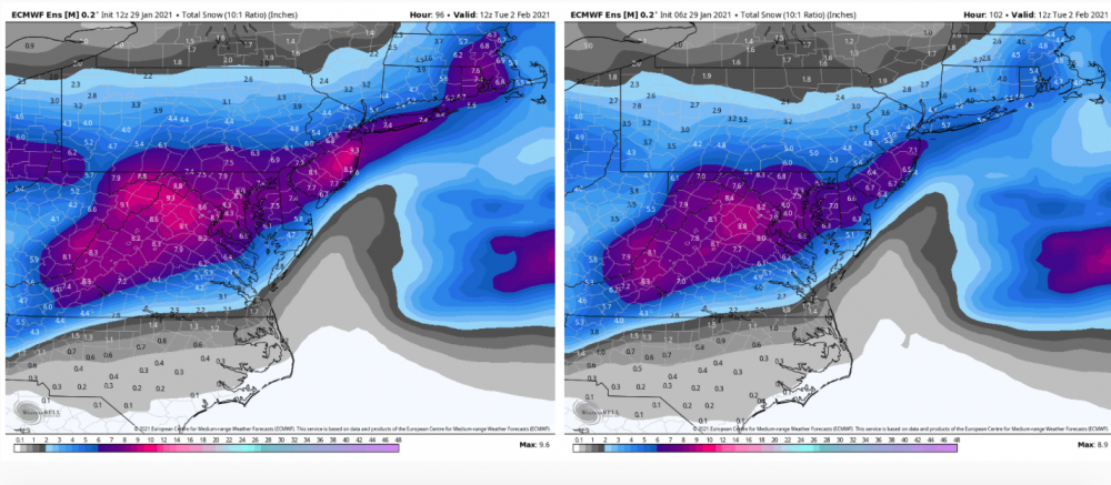
12z Euro ensemble has 6" mean solidly back into the southern tier. Best that's looked since 12z yesterday. CTP with it's opening snowmap:

-
Welcome back to C-PA, Euro.
-
Probably isn't going to break any in here compared to that god awful 0z run last night.