MAG5035
-
Posts
6,054 -
Joined
-
Last visited
Content Type
Profiles
Blogs
Forums
American Weather
Media Demo
Store
Gallery
Everything posted by MAG5035
-
Central PA Winter 25/26 Discussion and Obs
MAG5035 replied to MAG5035's topic in Upstate New York/Pennsylvania
Crushed.. the difference between this run and the 12z today is hilarious.
-
Central PA Winter 25/26 Discussion and Obs
MAG5035 replied to MAG5035's topic in Upstate New York/Pennsylvania
I’m at 114 here with the GFS and it’s looking better than the 18z run with expanse of heavier snows deeper into PA, it’s gonna be a good one. -
Central PA Winter 25/26 Discussion and Obs
MAG5035 replied to MAG5035's topic in Upstate New York/Pennsylvania
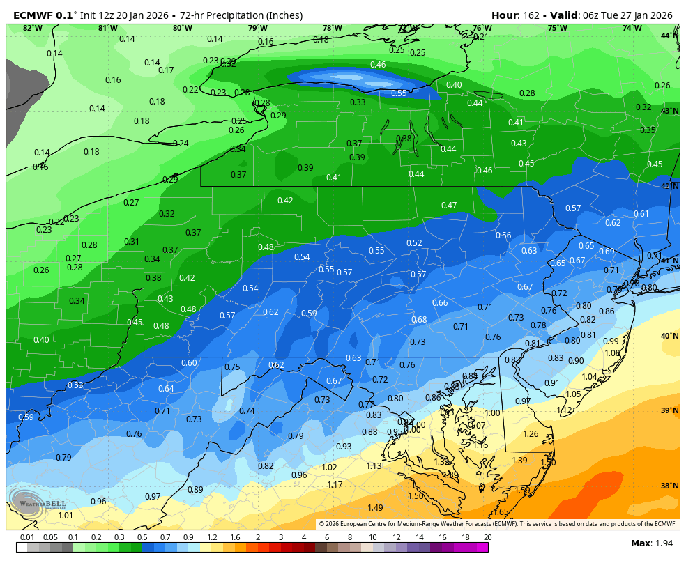
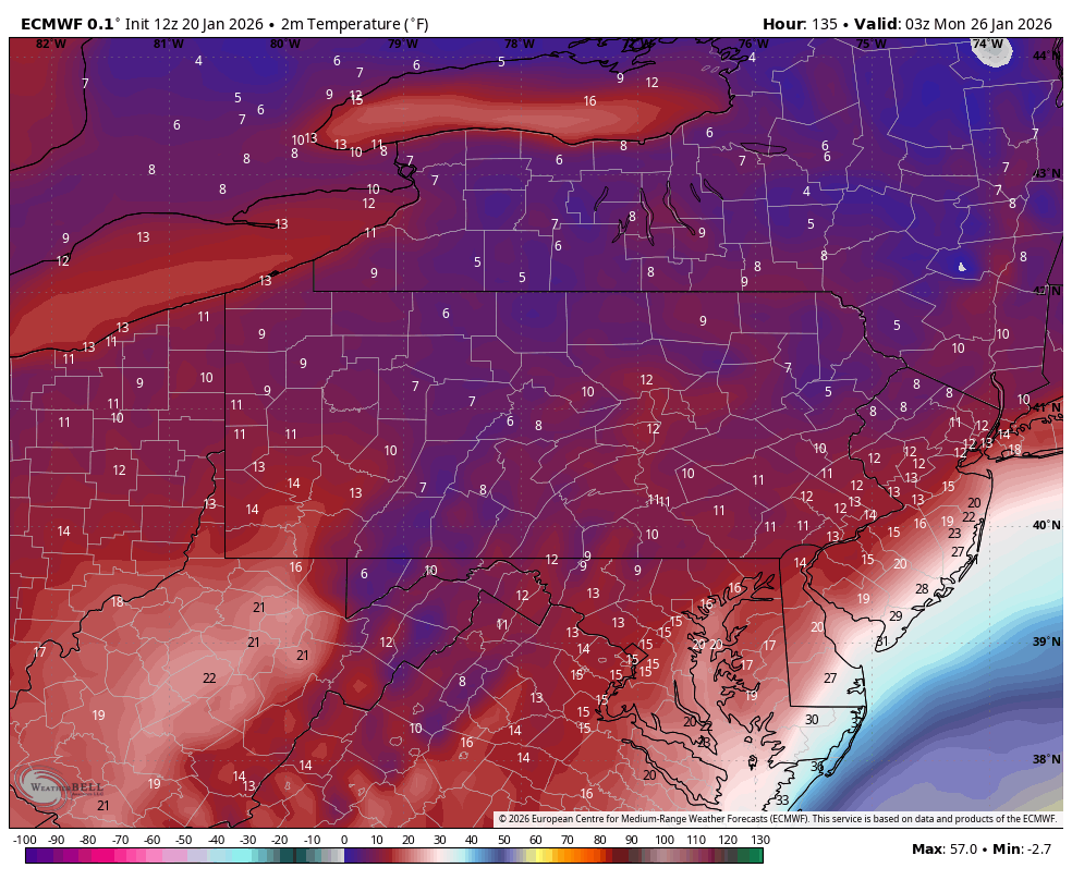
Here’s Euros total QPF, trying to separate the storm QPF from the event Thursday thats going to deliver several more inches of snow in NW PA. Also, surface temps for this are insane. Here’s the 135 hr frame, which was basically the best 6hr precip frame for our area. Temps are like that the entire event. Normally you see temps like that and would think one would be smoking cirrus. I know ‘96 started with temps that cold, but I don’t think temps stayed there the entire event. Even if we don’t see the best QPF the whole column is essentially in the ideal snow growth temp range.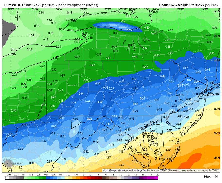

-
Central PA Winter 25/26 Discussion and Obs
MAG5035 replied to MAG5035's topic in Upstate New York/Pennsylvania
Man the Euro is a hammer. Snowing the whole way into Monday evening with an upper low passage and everything. -
Central PA Winter 25/26 Discussion and Obs
MAG5035 replied to MAG5035's topic in Upstate New York/Pennsylvania
I think in terms of the storm that could be at least partly true in terms of the Nina. More specifically it’s more of a function of the MJO in my opinion. It spent basically the whole month of December and the first 10 days of January in the null phase. So not much input from that, and we had northern branch dominated storm track that was very dry. Now there’s a pretty good pulse moving from 6-7-8, so I think that’s a driver in finally seeing a meaningful southern stream system show up on modelling. So the next question is what’s going to happen with it. I think as long as this thing comes out in one piece we will probably do well here. DT’s thoughts were posted a few pages ago saying about how important the MJO is and that it HAS to get into 8. Well for Richmond and that portion of the Mid-Atlantic, yea it probably does. Most deterministic guidance rapidly traverses 7 this week but doesn’t get there for this storm (close to 7/8 border). And this checks out with the 500mb pattern. 500 mb western ridge axis is in fact west of the classic positioning for C-PA. A more phased solution is going to build heights in the southeast as the storm comes out. It’s why I don’t particularly think a more phased and organized storm is going to get suppressed under us even with all the arctic air available. Now if energy is left behind and it comes out piecemeal, then sure… the heaviest precip will probably be to the south of C-PA. Even the improved 0z GFS run still left a lot of southern stream energy behind and there’s a big difference between that and the Canadian. Canadian phases it. Look at the height anomalies in the southeast even in the GFS case. If there wasn’t so much cold air in the pattern for this I would be more concerned about a more wound up system being some kind of a mixing event up into PA. But in this case I feel the more wound up scenario probably puts C-PA in the best snows. The key is going to be how these features come out and their interactions.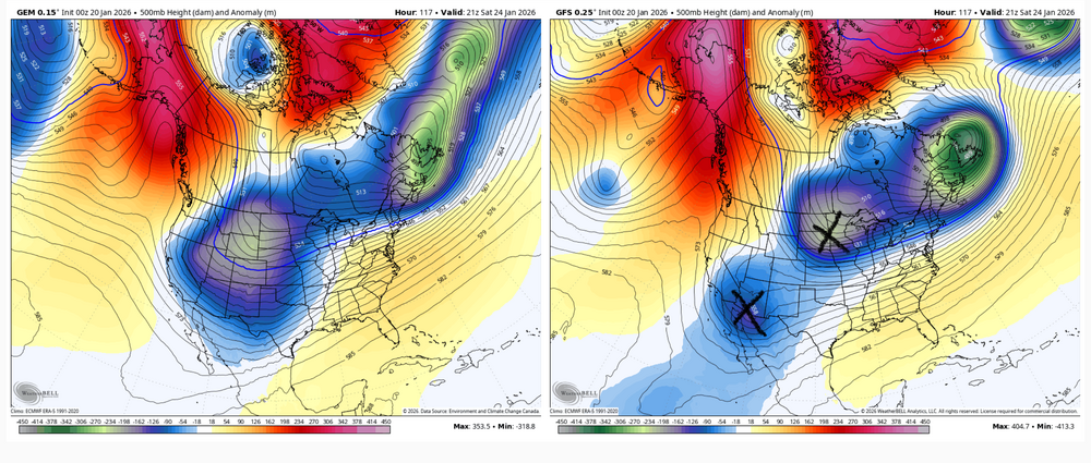
-
Central PA Winter 25/26 Discussion and Obs
MAG5035 replied to MAG5035's topic in Upstate New York/Pennsylvania
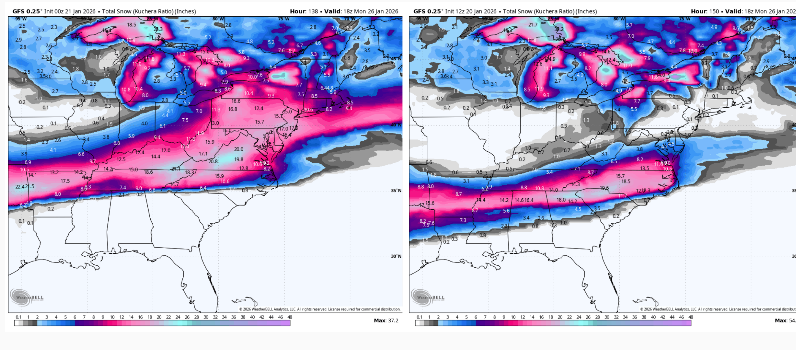
Big improvement for PA on the 0z GFS vs 18z run and especially the 12z today, where there wasn’t even measurable snow anywhere near us. 0z vs 18z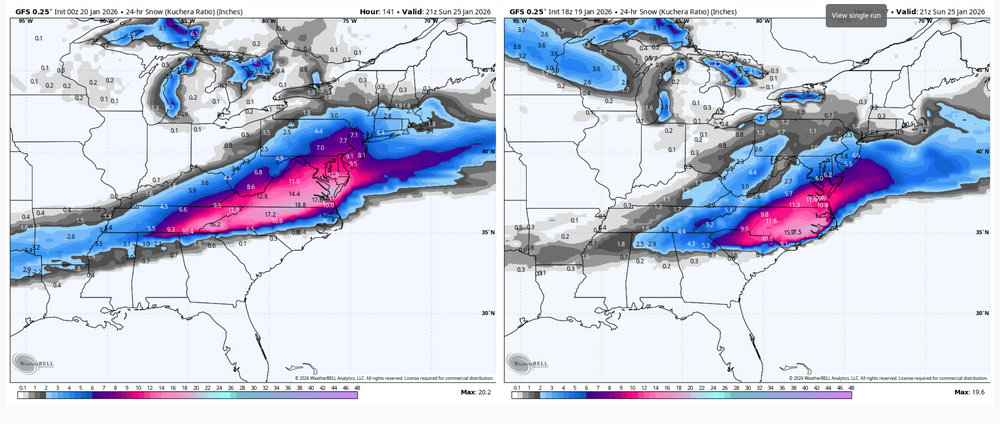
-
Central PA Winter 25/26 Discussion and Obs
MAG5035 replied to MAG5035's topic in Upstate New York/Pennsylvania
Early 0z stuff, regular NBM vs v5 NBM (newer version thats suppose to be fully operational in the spring). This has improved a tad for PA in the last couple runs. Right now I’m more watching this just for changes in the axis of the swath of heaviest snows vs any kind of amounts. But those kind of heavier amounts this far out is definitely a pretty strong signal considering the array of products that make up those NBM blends.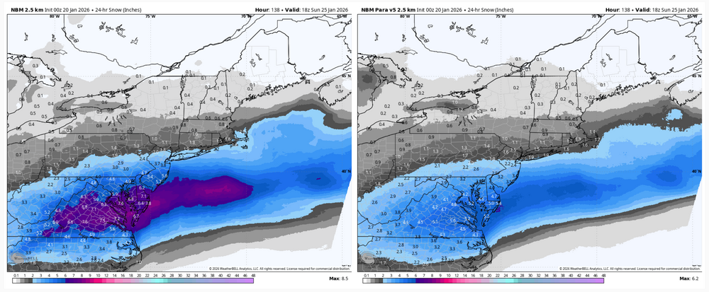
-
Central PA Winter 25/26 Discussion and Obs
MAG5035 replied to MAG5035's topic in Upstate New York/Pennsylvania
I had to quick delete because I pulled a rookie move and posted/commented on what was last nights UKMET haha. I’ll be very curious if the Euro continues to move its heavy snow swath our way. Regardless, I’m not anywhere near sweating the too far south/north solutions. But this energy has to all come out and not have a portion of it left behind like what the GFS has been trying to do. I think as long as that happens I like our chances. -
Central PA Winter 25/26 Discussion and Obs
MAG5035 replied to MAG5035's topic in Upstate New York/Pennsylvania
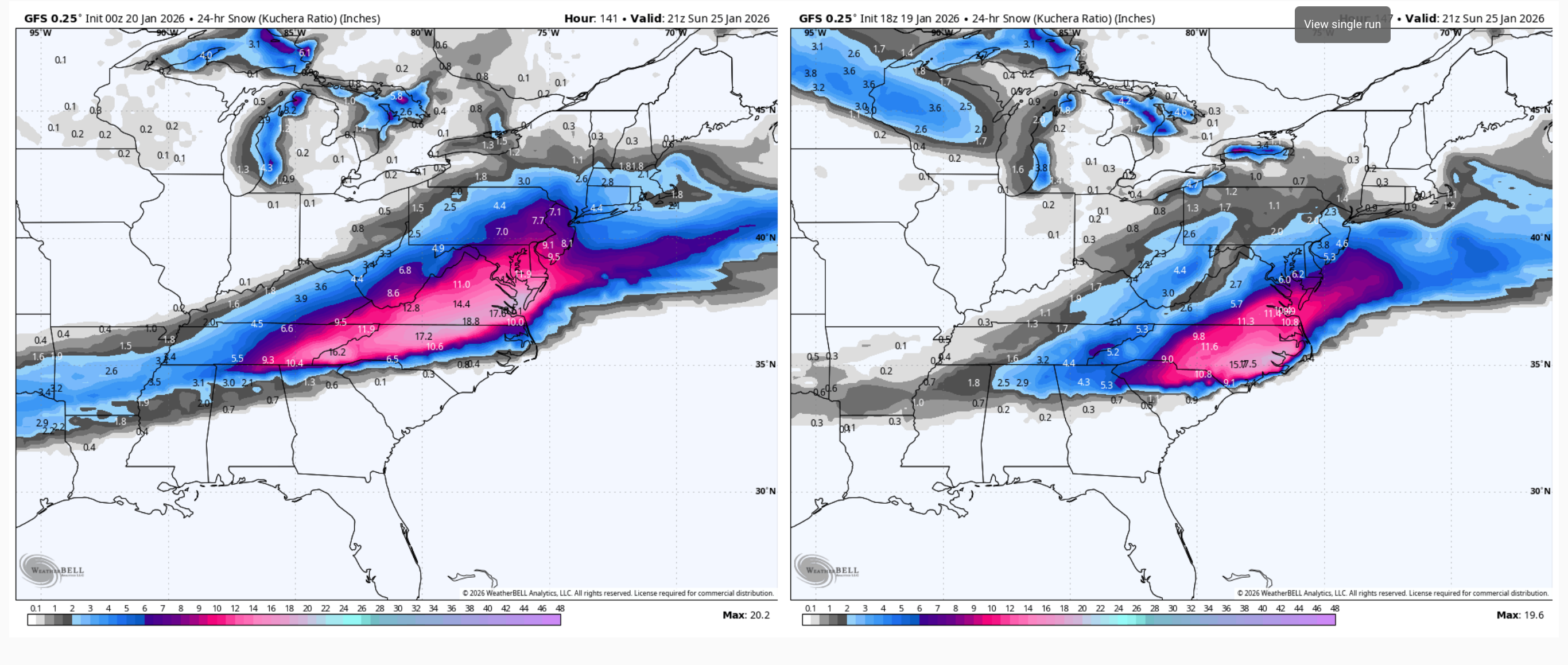
Nice to see the snow hole the central counties shrink some with the more robust than expected snow shield developing back further last night. Unfortunately I was only the recipient of a light coating, or heavy dusting (whichever sounds better) with the 1-2” plus snows either falling a few miles away up on the Allegheny ridge to the west or the next county over to the east. So bit of a bummer. With that said, screw it I’m going all in on next weekend. For the first time this winter the southern stream looks involved with a shortwave coming out with Gulf moisture to tap and there appears to be plenty of cold air and decent high to attack. This has the look of a widespread and significant winter weather maker for a big chunk of the country. Whether that’s here or south/north of here is going to be the debate this week as models are changeable as per usual. 12z GFS buries this in the Deep South, Euro not quite as suppressed but still a C-PA miss to the south after the previous 0z run had the mix line in southern PA. Ensembles showed variability with some hits in the mix. Both 12z GFS and Euro AI’s are big hits that are backed up with their AI ensembles. So we’ll see, we’re way overdue for an actual big precip maker. -
Central PA Winter 25/26 Discussion and Obs
MAG5035 replied to MAG5035's topic in Upstate New York/Pennsylvania
Steady light to moderate snow here with a fresh coating, 29ºF. This has turned into an outright accumulating event for some folks that it really wasn’t in the forecast for. US 322 corridor from State College to Lewistown showing a lot of snow covered roads on the cameras. -
Central PA Winter 25/26 Discussion and Obs
MAG5035 replied to MAG5035's topic in Upstate New York/Pennsylvania
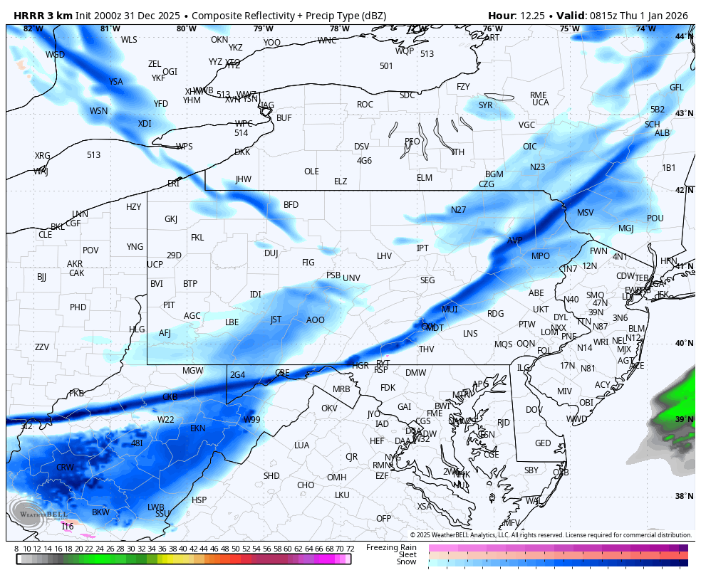
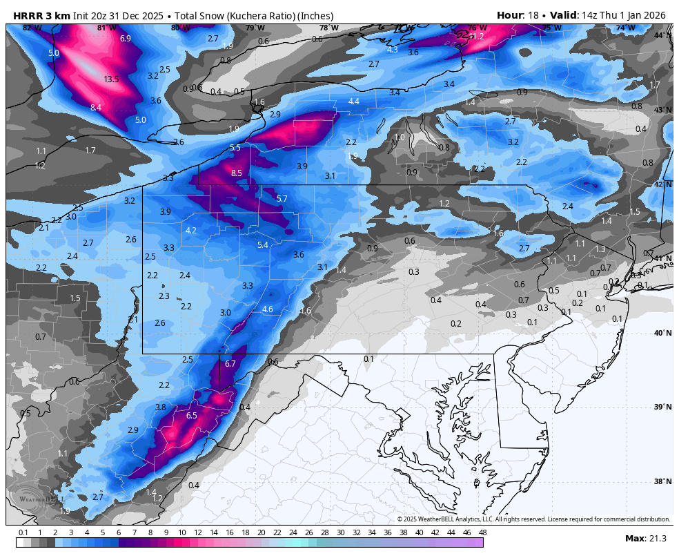
Pretty solid area of snow has blossomed up from WV over western and central PA the last couple hours. Something that the HRRR hasn’t really seen at all in recent runs where it doesn’t blossom precip til later over the Sus Valley. 0z 3k NAM looks to have seen that better as have the RGEM and globals. So I guess in other words, the HRRR is about the only thing that didn’t see that. Snow falling here isn’t doing much currently, but it is accumulating up in the Laurels per 511 cams. -
Central PA Winter 25/26 Discussion and Obs
MAG5035 replied to MAG5035's topic in Upstate New York/Pennsylvania
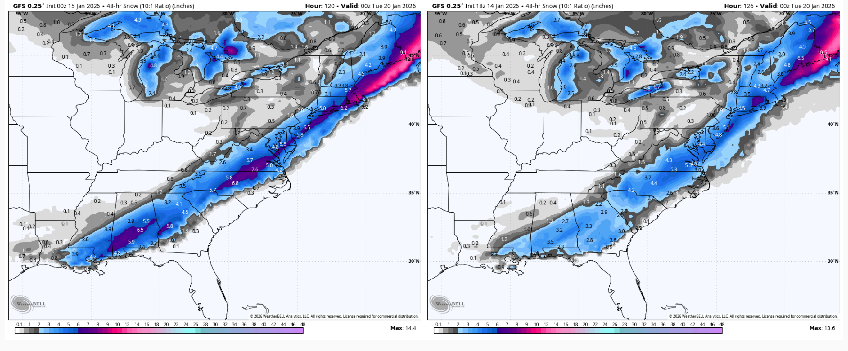
Nonsense or not this is the third run GFS in a row today that has shown a fairly impactful event running the whole way up.. starting all the way down in New Orleans with accumulating snow. Still not impacting C-PA or most of the LSV, but this is way more wound up than anything else. 0z vs 18z GFS. I’m using a 10:1 map so I can do the 48 hr total and separate out the other LES and light snows leading up to this. 18z Euro did try to come toward this scenario a bit, having a snow swath down to the Gulf Coast (starting in FL panhandle) but not as robust and mostly offshore. I dunno, progressive and positive tilt along with a lack of phasing probably argues towards the Euro end of things. On the other hand, could argue this has room to come west given axis of what is now a massive western ridge is along the Pacific Coast. New RGEM and Canadian don’t dig the responsible shortwave anywhere near as far down as GFS/Euro and it comes out faster and fires the coastal by Sunday morning off the Mid-Atlantic coast. This actually does impact C-PA with lighter snows but really impacts New England, pretty much a late blooming coastal solution for us with no snow anywhere near the Deep South. Certainly a lot of differences for an event that’s already starting in the outer reaches of NAM range.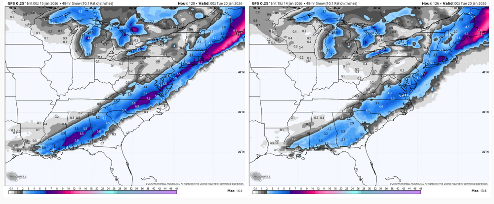
-
Central PA Winter 25/26 Discussion and Obs
MAG5035 replied to MAG5035's topic in Upstate New York/Pennsylvania
It’s certainly a bit of a long shot but the big storm option is definitely on the table. There’s a lot of energy dropping in amplify this trough and it’s darn near an all out phase and explode type east coast storm. I have the 18z solutions below and you can see the distinct shortwaves lined up, but still on a positive trough axis. The trough eventually goes negative but it’s takes time and doesn’t seem to phase features cleanly/completely, which still yields some kind of event but not a storm of the nature that has occasionally been thrown out by mainly the GFS. Some things to consider, regardless of any eventual storm evolution this looks to be a fairly potent trough and closed 500mb low that develops over or just under PA. I think that alone will probably generate a swath of snows somewhere in central and/or eastern PA as the trough goes negative. Another thing to consider is temps. Tomorrow will be cold and windy but this is a quick cold shot that moderates rapidly for the first half of the week. Temps will likely be mild (5-10ºF above normal) first half of the week right up to the early stages of this digging trough and associated coastal potential. If we do get a storm it will be preceded by mild to marginal temps, esp in the Sus Valley. So when it’s probably 50ish there the day before, don’t be surprised. -
Central PA Winter 25/26 Discussion and Obs
MAG5035 replied to MAG5035's topic in Upstate New York/Pennsylvania
One thing to keep an eye on is the MJO, which has been in the null phase for most of the last few weeks (not a major influencer). Models are forecasting it to finally strengthen, with most sending it solidly into Phase 6 later next week (esp GEFS). Euro guidance was more toward the border of Phase 6/7. Phase 6 is more often than not one of the eastern US torch phases with a high degree of corellation. Given some lag time this would generally suggest another warm period coming at some point possibly late month. Ensembles are definitely NOT showing much signs of that today temp-wise in the D10-15 range. So this will all be interesting to watch evolve. EPO/WPO are forecast to go pretty negative in that 10-15 day range along with a -AO/NAO. One of the few more recent examples of it not mattering much being in the warm phases was 2014 and 2015, and the main drivers of the cold those winters were in fact a persistently strong negative EPO/WPO. -
Central PA Winter 25/26 Discussion and Obs
MAG5035 replied to MAG5035's topic in Upstate New York/Pennsylvania
The timeframe around the 15th or so has fairly consistently looked like it could be the best attempt at amplification we’ve seen so far this winter, which is definitely not saying much. Whether or not we can get some better phasing of features there remains to be seen, and probably will for a good while yet considering the range and model performance lately. There’s some potential there though, and during a period next week which should be at least seasonably cold. But in the meantime while we’re warmer and occasionally raining the next few days, 30 year anniversary of the Blizzard of 96 highlights might have to fill the void. Regarding the lack of bigger coastal snowstorms as of late in our neck of the woods, the Northeastern US apparently hasn’t had a RSI (NESIS) rated event since March 12-16th, 2023 (I had to do digging just to remember what that one did). There’s a slight chance the event right after Christmas might’ve snowed enough over more populated areas (NYC) to be a minimally rated one and hasn’t been added yet, but the point still stands. The last major rated NE storm was the Jan 31-Feb 2, 2021 storm. -
Central PA Winter 25/26 Discussion and Obs
MAG5035 replied to MAG5035's topic in Upstate New York/Pennsylvania
2.7” was the general average around the yard I got for last night, so not too bad of an event. Only 18ºF out currently. -
Central PA Winter 25/26 Discussion and Obs
MAG5035 replied to MAG5035's topic in Upstate New York/Pennsylvania
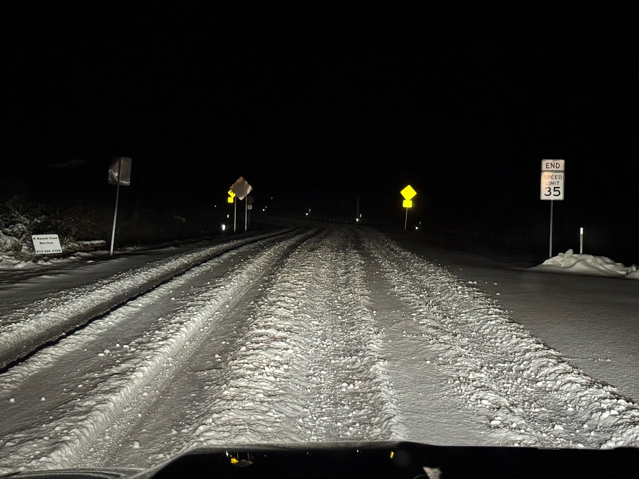
It’s still snowing quite hard, I’m pretty sure I have in the ballpark of 2-3” total but it’s been blowing around so much that it is going to be hard to get good measurements. Temps just prior to the squall arrival were up as high as 31.5ºF and now 45 minutes later it’s 21ºF. Looks like a rough go of it on the roads right now. This is the closest 511 cam to my house, about half a mile away. -
Central PA Winter 25/26 Discussion and Obs
MAG5035 replied to MAG5035's topic in Upstate New York/Pennsylvania
It’s here, whiteout and gust to 39.4mph -
Central PA Winter 25/26 Discussion and Obs
MAG5035 replied to MAG5035's topic in Upstate New York/Pennsylvania
This snow squall band continues to have occasional lightning strikes in it. -
Central PA Winter 25/26 Discussion and Obs
MAG5035 replied to MAG5035's topic in Upstate New York/Pennsylvania
Have about an inch on the snowboard so far, getting into a bit of a lull ahead of the snow squall line. Winds have been surprisingly feisty for most of the duration of this early steady snow with a lot of 25 mph+ gusts. So snow’s been blowing around a good bit. -
Central PA Winter 25/26 Discussion and Obs
MAG5035 replied to MAG5035's topic in Upstate New York/Pennsylvania
27ºF and steady snow arrived here in the last hour, with a fresh coating so far. We usually do pretty good with these kind of events here right off the ridgeline. CTP expects about 2” here in Altoona and I think that should be pretty attainable between the steady snow and the expected snow squall line. -
Central PA Winter 25/26 Discussion and Obs
MAG5035 replied to MAG5035's topic in Upstate New York/Pennsylvania
HRRR really maintains the snow squall line pretty much all the way through PA overnight. Passage timing is about 130am or so for AOO/UNV/IPT and during the 3am hour for the LSV. Gonna be moving quickly but could put a half inch or so down in spots. Pre squall snowfall really falls off a cliff once east of I-99. West of there and especially up in the Laurels will be a wintry go of it this evening.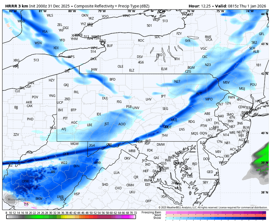

-
Central PA Winter 25/26 Discussion and Obs
MAG5035 replied to MAG5035's topic in Upstate New York/Pennsylvania
Models have not done well in the mid-long range this winter, which might sound like a captain obvious thing to say but typically they’ll get a general idea of the overall pattern in the 6-10 day range. I don’t personally think the highly touted AI models have done notably better either. I’m sure it’s an expectation thing with folks that with everything available that forecasting just HAS to get more accurate. My opinion on AI modelling is while I’m sure it excels at pattern analysis, it’s still only as good as the initial data/information you’re putting into it. Which basically puts it in the same boat as the standard physics based models. You still need accurate observation data/sampling, and preferably.. the more data points the better. Anyways, I think the high changeability on modelling stems from a few things like blocking (NAO), which models never do well with. MJO is also in the null phase and forecast to remain there for the foreseeable future, so there’s no real coherent signal from that realm. I’d be more willing to buy what the MU guy is trying to sell about January if we were staring down a strong and long lasting pulse into phases 4-6, but we’re not. Another reason is simply our general area has been in a spot where the high variability of the models has had the biggest impact on actual forecast weather differences. I did originally like the storm potential around the 8th/9th a few days ago, but I do believe the models are starting to register on the EPO and WPO going positive in that timeframe to go with a -PNA. The WPO has been solidly negative the last few weeks and a big reason why there’s been plenty of cold available in Canada. That’s probably going to overcome the -NAO and is why we’re now seeing eastern ridging and a more rainy looking scenario with systems around then. But that doesn’t look to last, we keep the negative NAO and the WPO/EPO is forecast to go right back negative. So while that period next week isn’t looking as great, I think things still tend to look at least seasonably cold overall in the longer term and we’ll have opportunities. My big issue with this winter has been actual storms (Gulf sourced/coastal), we’ve had a real lack of them this season dating back through the fall. -
Central PA Winter 25/26 Discussion and Obs
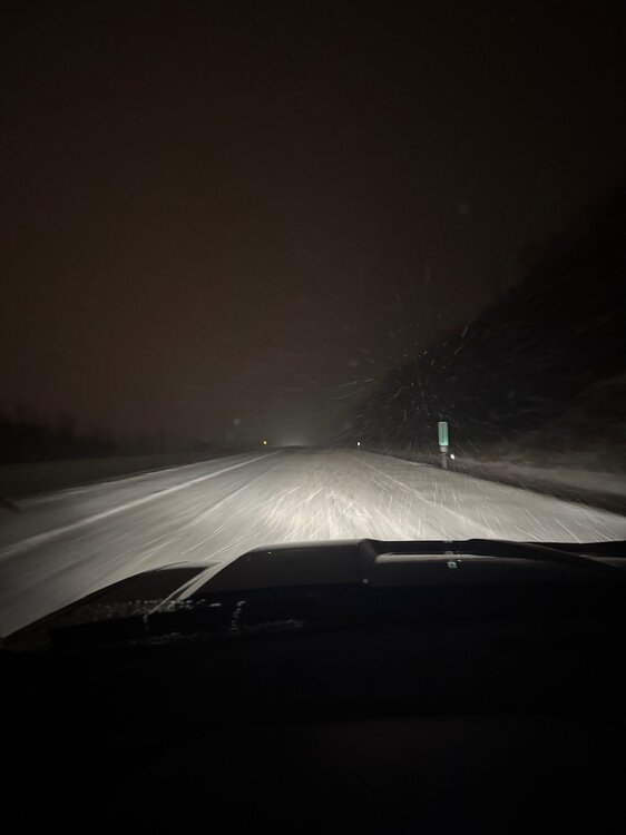
MAG5035 replied to MAG5035's topic in Upstate New York/Pennsylvania
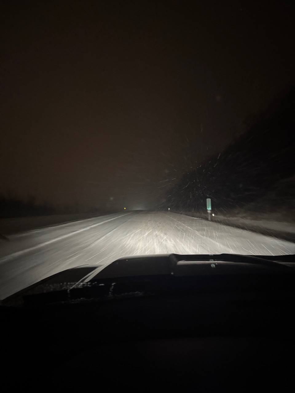
Despite pretty high winds, the most impactful weather has shifted over to the snow bands that set up late this evening/early this morning in combo with the winds of course. Opted for a late night snow chase on a band that set up in northern Blair/NW Huntingdon a couple hours ago and it ended up being worth it. Some folks probably saw their biggest snowfall of the season to date under it. 2-4” was common on the I-99 corridor roughly between Bellwood-Tyrone, carrying over into Huntingdon County. Very impressive for a LES band being off the Laurel’s. I-99 between Tipton (Exit 45) and Tyrone (48) PA 45 in Spruce Creek, PA (NW Huntingdon) This band missed here by about 6 miles or so, there’s only about a half inch of wind blown snow here at the house.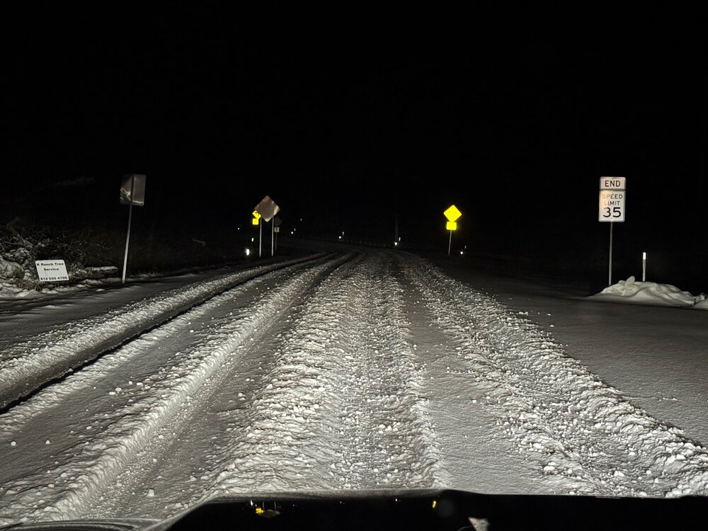
-
Central PA Winter 25/26 Discussion and Obs
MAG5035 replied to MAG5035's topic in Upstate New York/Pennsylvania
That’s right around where I bottomed out about 7-8am this morning (about 993.2mb). Up to almost 999mb now.