SnowDawg
-
Posts
1,082 -
Joined
-
Last visited
Content Type
Profiles
Blogs
Forums
American Weather
Media Demo
Store
Gallery
Everything posted by SnowDawg
-
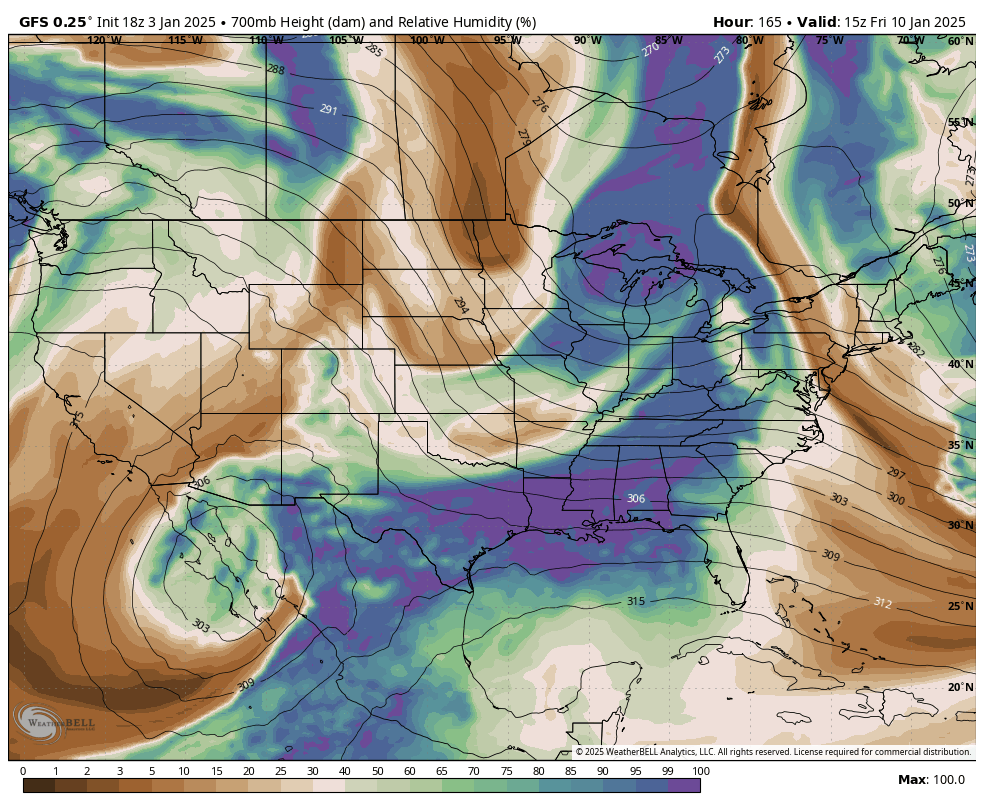
Euro is actually much colder in the mid-levels than the GFS was just need better rates. I wouldn't expect as wild of run to run swings from the Euro, but at least it was a tick in the right direction.
-
Yeah, I think I've mistakenly been hoping for a weaker system to reduce warm air advection, but all the weak runs are terrible. Stronger runs are pulling more cold air from nearby into the system. I'm fine with a messy winter storm, I mean that accounts for like 95% of our events, but I'd really like to score nicely on that front end before the mixing starts. GEFS also jumped considerably colder at 850 compared to 6z.
-
H5 was improved on the GFS, I'll take that and move on to the next runs. Better phase with the northern energy improved the mid-level thermals and made the front end thump last longer.
-
I'll just say, and this is not analysis of any kind, but I'd say that kind of freezing rain is rarely that widespread and I'll belive it when I see it. Better/deeper low level cold from the snow pack to the north could give us a ton of sleet which I'll take any day over zr.
-
Yeah I see what you're saying. I'm just worried about more amplification if our mid-level thermals are already such a problem.
-
These trends are just plain bad no sugar coating it. I'm just glad we've got as much time as we do to maybe trend back the other way with more confluence over the top.
-
Would really like to get back to southern slider solutions. That is a mid-atlantic storm.
-
If there's a time frame to trend towards dry and suppression I'll take it now as opposed to later. With how often things tend to windshield wiper on the models, plenty of time to trend one way for a few runs and then back the other way.
-
Name of the game on both ensembles at 12z was to lower QPF on the northern side and have more dry sheared out members. Long ways to go still, and still many different scenarios on the table. The various pieces of our system will move on shore over the next few days, so should start to get some better sampling.
-
GEFS with a warning shot that suppressed and largely dry is very much still on the table.
-
I'd bet as long as the setup continues to be modeled as is, low level cold will improve as we get closer. There is a CAD signature as our storm is moving in, albeit light. Even in normal circumstances these are usually underestimated by the global models, and this time the damming high will be sitting right on top of fresh snow pack in the mid-atlantic.
-
GFS again shows the best option may be to leave that baja low behind.
-
This storm up north trended south the last couple days after trending north before, maybe we can get the same luck. Also is showing a bit of CAD which one can hope is under-modeled at the time.
-
I think I have seen a tweet from some met in the last couple months saying that the Euro AI was bad with surface depictions, but was scoring well on large scale setups, but I can't remember now who it was.
-
If this thing is gonna be amped up, it's all gonna come down to how the 50/50 trends. Confluence will be our friend here both on track and thermals. Without it we need to go back to the weak overunning looks from yesterday afternoon.
-
Never thought I'd be jealous of a few stray snow showers, yet here we are lol. Still only a few tiny pin-flake flurries for me since 2022.
-
Despite the largely missed phase the baja low is still helping us out by setting up a moisture feed off the pacific. This may honestly be the look to pull for, with less chances of failure.
-
True true. I suppose it largely depends where you live and what you're used to. Despite the near 3 year drought, at nearly 2000 foot elevation I still see anything under 2 inches or so as light. Maybe time for new expectations though...
-
Phase almost entirely missed but still just enough energy to briefly inject some gulf moisture. The northern stream didn't really dig SW which made the cold press a little more direct into the SE. My guess is that the only path to bigger snow without temp issues is for the baja low to come east and meet the northern stream, not vice versa like 12z showed. If it digs hard SW then a brief ridge tries to pop in the east and we warm. That being said, I'd happily take a widespread light snow as shown.
-
Though nothing to write home about that EPS run was actually a small improvement from 0z. We've really just sort of waffled back and forth with the handling of the baja/northern stream interaction over the last 48 hours or so.
-
Yeah that's definitely on the table. I think it was Eric Webb that was saying this setup is sort of big amped up storm, or squashed all the way into the Gulf, with very little in between. And when it comes down to those two scenarios, well we are unfortunately forced into a my backyard contest. Something like the Icon just means sunny, cold, and windy for me. While a GFS solution is close to a classic I-85N winter storm, with the admitted thermal risks. Just the unfortunate reality of the geographics of this board, systems that make us all happy are practically once in a lifetime events.
-
Block and 50/50 have trended weaker on the GFS. But admittedly, some of that weakening may be responsible for us having a storm at all and not a suppressed strung out mess. Gonna have to strike a balance between giving our wave room to amplify but not invite too much ridging in front of it wrecking thermals.
-
I'm not gonna overly fuss about p-types until we actually have a storm in hi-res model range. Right now close is close enough for me. Let's actually get that snow pack on the ground to our north, and see how the models adjust.
-
EPS looks much better than the GEFS. Even shows a low pressure anomaly in the northern gulf.
-
Op euro with another tick towards the GFS. GFS just had a slightly better attempt at the phase so it was a bit stronger. Like having op euro at least somewhat onboard for sure though.