

Matthew70
-
Posts
643 -
Joined
-
Last visited
Content Type
Profiles
Blogs
Forums
American Weather
Media Demo
Store
Gallery
Posts posted by Matthew70
-
-
Here is Boro just some wind damage reports. I believe Jax is in Williamson which had a lot of wind damage reports also. The tornado warning went right over my house. Fortunately just insane winds. Most intense since moved here in 2005.
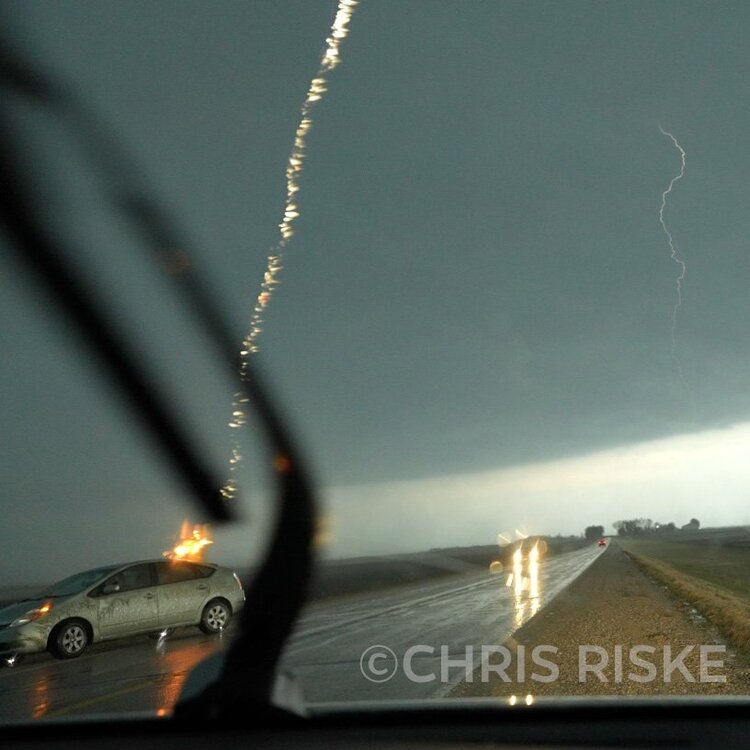
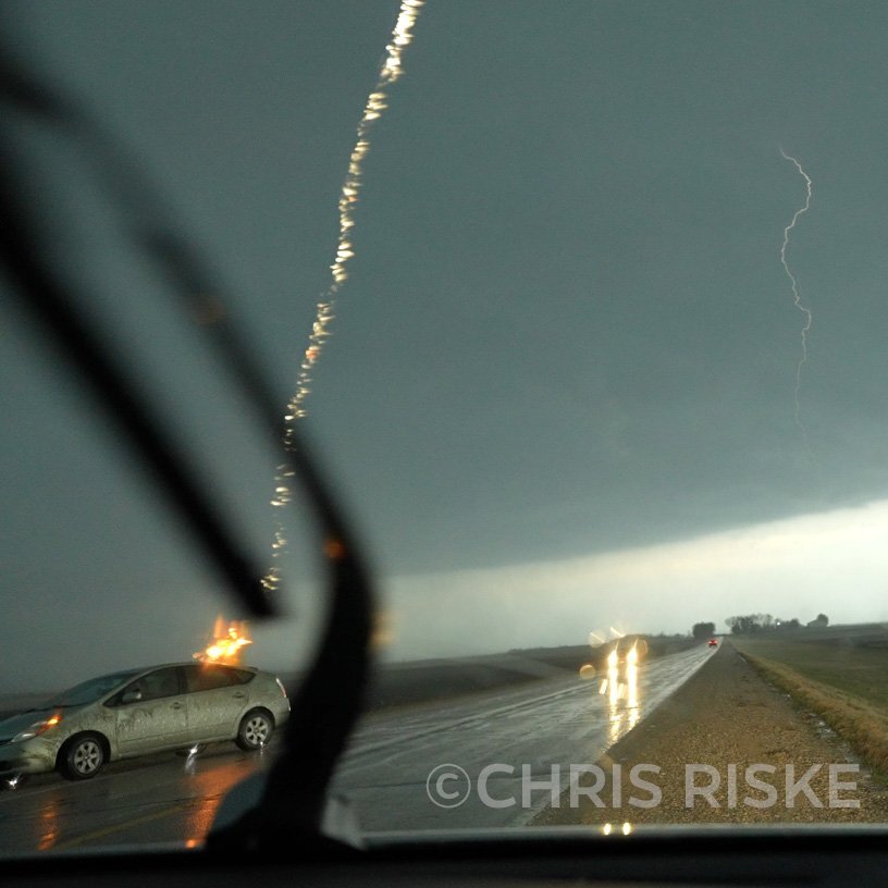
The pic below has a video also. Still figuring out how to copy paste link. That vehicle is totaled after that lightning strike. Circuits & boards fried.https://twitter.com/RiskeChris/status/1514388956040867846?s=20&t=GsIQwKJ27GuN6t80O-EWgQ
-
 1
1
-
 3
3
-
-
1 hour ago, jaxjagman said:
Best thunderstorm in awhile here in Brentwood right now.Even dropping some pea sized hail
Yes here in Boro was the same. Been awhile it seems with some good lighting. The flash flooding is also impressive.
-
1
-
-
Thinking more ARK & north.
-
1
-
-
Leconte has 6.5” today.
-
4
-
-
I’m ready for spring to stay. It’s been a cold soccer season so far.
-
3
-
-
8 hours ago, Holston_River_Rambler said:
He sure is closer than I would feel comfortable. You just never know if the water has soften the ground around the edge. Great video but one slip & yikes.
-
1
-
-
Paducah sleet fest. Yuck.
-
1
-
-
3 hours ago, jaxjagman said:
Yeah downtown Franklin might be under water,we will see.Euro seemed tohave back down somewhat this afternoon
I saw where OHX NWS only has 3-4” now for area. That’s not nearly as much as first thought. Guess models have backed off a lot.
-
53 minutes ago, jaxjagman said:
Hydrologic Outlook
National Weather Service Nashville TN
516 AM CST Sun Feb 20 2022

...Flooding Possible Washingtons Birthday through Friday...

Moderate to heavy rainfall will impact Middle Tennessee Washingtons
Birthday through Friday afternoon as two distinct weather systems
move across mid state region. As of this time, total rainfall
amounts will range from around 3 inches southwest to approaching
6 inches northwest through Friday afternoon. Currently corridor
of heaviest rainfall amounts look to be across northern portions
of mid state region as Tuesday progresses. There may be a brief lull
in rainfall on Wednesday. However, another round of heavy rainfall
is expected to arrive Wednesday Night and last through at least
Thursday night, with heaviest rainfall amounts expected Thursday
night.

Soil moisture continues to remain relative high especially across
northern portions of mid state region. Due to this rainfall
potentially causing additional rises on rivers, several rivers
across area could reach action if not flood stage as week
progresses. Flash flooding could also be possible across mid state
region.

While the exact location of higher rainfall amounts not yet totally
certain, it is imperative that if you have interest near areas that
are known to flood, that you pay close attention to rainfall
forecasts over the upcoming week. Updated information concerning
this rainfall event will be provided during morning hours on
Washingtons Birthday.
Definitely will be some river flooding along with certain areas this week. My back yard will be a small pond & swamp for sure.
-
On 2/18/2022 at 7:06 AM, Holston_River_Rambler said:
Antediluvian Flood Watch
Podunk Weather Service Mossy Grove
757 AM EST Fri Feb 18 2022

...The Podunk National Weather Service in Mossy Grove has issued an Antediluvian Flood
watch for the following areas...

  TN Valley watersheds

For the TN Valley watersheds ...including, but not limited to: Lancing, Nod, Deer Lodge, Frog Level,
Carter's Valley, Oneida, Boring Chapel, Riverfront Seafood, Boozy Creek, Blackwater, Melungia, Knoxville, elevated river levels are
forecast.

PRECAUTIONARY/PREPAREDNESS ACTIONS...

Stay tuned to further developments by checking TN Valley Banter often, look to your local augur,
entrail reader, or even Raven Radio for further information.


The next statement will be issued no later than 24 hours after the next bonkers GFS run.

&&


TN065-182245-
/O.NEW.KTYS.FL.Y.0027.220218T1037Z-220223T0018Z/
757 AM EST Fri Feb 18 2022

...ANTEDILUVIAN FLOOD watch IN EFFECT FROM EARLY THIS MORNING THRU WEDNESDAY PM

* WHAT...Flooding caused by excessive rainfall is shown on GFS runs

* WHERE...TN Valley watershed

* WHEN...From early this morning to Wednesday PM

* IMPACTS...At 14.0 inches of rain the 0z GFS done went there.

* ADDITIONAL DETAILS...
Ark building prep is RECOMMENDED, but not MANDATORY at this time...

That is funny but that much rain will be very problematic for the oprymills along with many other areas. As for my ark. Not sure how big I can build it in the time given. Might have to leave some animals off. Snakes & skunks will be first to be cut. Thanks mossy for the update.
-
3
-
-
I’m hoping the models are overdoing the rainfall amounts. Especially for the first system. We get those type of amounts Id say it’s a good bet many schools will be closed Wednesday if not Tuesday. Maybe even half a day on Tuesday. Rivers are already high.
-
2
-
-
For the majority outside of mountains & higher elevations. It’s most likely cold cold rains here in mid state. I will take a hard pass on those. Please.
-
Looking at my forecast. It looks way to warm for anything but rain. To me it looks like spring arrives starting Sunday. Am I missing something or is forecast wrong on temps?
-
1
-
-
Flooding is going to become a major issue moving forward into spring here in the mid state. Of course 2.5”-5” of rain next 2 days will definitely lead to some issues I’m sure.
-
14 minutes ago, John1122 said:
The meso low in middle Tennessee looks healthy out that way, but not sure of the ground truth there.
Solid dusting here near Murfreesboro. Much more than I expected.
-
3
-
-
Please Titans. Send Tannehill & the off. Cord. Packing tonight. They both suck.
-
1
-
-
14 hours ago, nrgjeff said:
Yeah I'm going to have to reject that ice forecast in the utility business. Just no!
I bet the main January thread is depressing. Do I even want to look?
Welllllll… The thing that is depressing me is the higher heating bill that will be coming for this dry & cold wx.

-
1
-
-
Nice big flakes here again but it’s a big ole slop fest. Took dog out & its like a swamp.
-
1
-
 1
1
-
-
30 minutes ago, Bigbald said:
Per what model run? What deterministic measure are you using?
Yes it can change quickly but as of now the middle & west part of state is looking mostly dry & cold. A lot of times if air is to cold. It pushes the storms to south of area. I sure hope that changes.
-
I hope it’s not cold & dry for middle TN but it sure looks that way. Par for course unfortunately.
-
2 minutes ago, Carvers Gap said:
We are either going to be...
 or
or  or
or  or
or  ....but for now I am
  . Seriously @Kasper, I post a lot when the board is quiet, especially medium and long range stuff. But when you all are doing the discussing, it is a blast just to sit back and watch the forum go to work. And man, the 18z GFS looked good. This storm is likely the beginning of about a 12-14 day cold shot. Fingers crossed that the STJ stay active. We are likely in a good spot for once during the last two weeks of January.
@carvers Looked good for this storm or after?
-
19 minutes ago, TellicoWx said:
For the NBM:

To me that model sucks.
-
2
-
1
-
-
1 minute ago, PowellVolz said:
Low pressure goes due north 150 miles in the last two time frames. Nothing would surprise me with this system but that doesn’t seem realistic without some blocking it seems.

.Thermals seem way off of what kinda precip is falling.
-
1
-
-
9 minutes ago, *Flash* said:
21z HRRR coming in a bit juicer. Verbatim, not a bad statewide hit.
Anyone got pics


Spring/Summer 2022 Medium/Long Range Forecast Discussion.
in Tennessee Valley
Posted
I read somewhere maybe here that it’s possible to continue to have these well into May. Which would keep severe wx season not as active for these parts but also make it feel like we went from winter straight to summer. Though I do love 60’s for highs. Hardly any insects & no skitters. Fescue just loves it with rain. My yard might be best I’ve ever seen it. For me anytime we can delay upper 80’s & 90’s till at least June I’m good. This has to be the most wind for a season that I ever remember. The last 2-3 months have been windy.