

Matthew70
-
Posts
647 -
Joined
-
Last visited
Content Type
Profiles
Blogs
Forums
American Weather
Media Demo
Store
Gallery
Posts posted by Matthew70
-
-
5 minutes ago, Carvers Gap said:
Euro was a good pass, but not nearly as much for the valleys. That said, we are going to see a lot of variations this far out. Both the GFS and Euro have some Miller A in them.
I’m ready for that hot sign to be showing up on a thread.
-
 3
3
-
 2
2
-
-
Did Euro give us any whiteness?
-
I love seeing so many comments when I look. Means possibilities of snow!
-
2
-
-
2 minutes ago, John1122 said:
Wild, wound up storm on the Euro. Wraps in incredible cold and snowy weather across the region.
We need some white on ground if it’s going to be this cold!
-
2
-
-
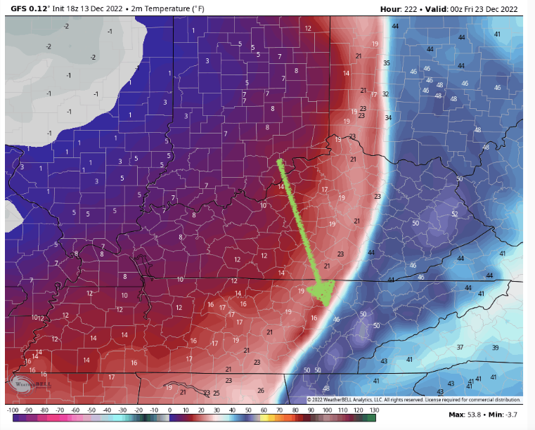
1 hour ago, Wurbus said:
That was one cold GFS run. East TN below freezing from the 23rd-29th if that verifies.
Let’s just hope snow is on the ground instead of brown & dry.
-
5
-
-
58 minutes ago, Carvers Gap said:
Cold front gradient! Cold 8-14 day forecast by NCEP.
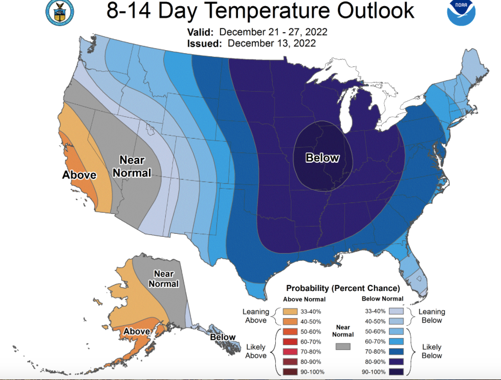
I would believe that if there is any moisture such as rain before that front, it would flash freeze once the front goes through.
-
2
-
-
I’m hoping to see some clown maps soon. If it’s going to be that cold please at least let there be snow on the ground. Dry & brown does not work for Santa’s sleigh.
-
5
-
-
3 hours ago, Runman292 said:
Good morning, everyone. It's been a while since I've last been on here. I'm sorry that I haven't been posting since last winter, but I've had a pretty rough year. In February, I started getting daily headaches and migraines out of nowhere. I've had a few migraines that have mimicked strokes, which was really scary. On top of that, my wife had a "widow maker" heart attack at the age of 33 in June. I'm hoping that 2023 will be better for me and my wife, and that we get a lot of snow this winter.
Very sorry to hear this. I hope you you & your wife get better & continue healing. I understand rough year. I still suffer with long Covid. Have good days & bad days. Cough will never go away. I’m alive though. Let’s hope 2023 is a great year for everyone! Here is to a white Christmas if it’s going to be very cold. Put he’s cold air to use.
-
1
-
-
1 hour ago, Icy Hot said:
I love our forum but the constant flow of ads is ruining it. Absolutely drives me nuts with ads popping every 5 seconds.
I don’t see ads at all.
-
33 minutes ago, EastTNWeatherAdmirer said:
The GEFS and latest GFS runs want to keep next week’s trough hanging back in the western United States. Really quite remarkable; as Carvers likes to say the word, a “coup” is forming between the models. The Canadian, European, and both of their ensembles want to keep the “bowling ball” rolling across the lower 48 by Wednesday of next week which would ultimately allow an ULL to drop deeply into the southeast and mid atlantic, drawing down very cold air, mountain & maybe plateau snow by late next week into the weekend. This ULL, with enough assumed forcing and moisture inflow from the Atlantic, could create a pretty gnarly wrapped up snowstorm for New England and the Northeast Atlantic Corridor by next weekend. That’s one resolution, and the Canadian and European are betting on that right now.
However, I beg to differ. If we recall, there have been a few systems noted by global models to be big snow makers that never came to fruition at all because of how the primary trough hasn’t been in its prime location(eg, -PNA trough & 50/50 low only mean one thing for sure…and that’s plenty of cold to folks living far out in the western US and a reduced risk for any impactful Midwestern, Ohio Valley, Mid - Atlantic, or Southeastern Snowstorms). We thought the arrival of major cold would be Dec 9/10 several days ago. Instead, we have seen a weak but very persistent southern ridge allow mild air to surge north, with the western US states being very cold and the far northeastern United States remaining quite chilly, because of the concrete 50/50 low hanging out up there. Like I’ve said, the Euro and Canadian show next week’s upcoming system effectively undercutting the blocking and negative NAO with a really impressive ULL stationed over the Ohio Valley along with East TN valley flurry and mountain snow activity. Instead of the system becoming a fully autonomous upper level cyclone like that, latest GFS and GEFS trends want most of the ULL itself to stay in the Northern Great Plains, Pacific Northwest and Western US as a whole, with only a weak exchange of lower height anomalies being *transferred* across the central US and Mid-Atlantic, with less deep cold here and no New Eng or App Storm. The front would still come through with rain nevertheless, but much of the cold and upper level low pressure activity and lower thickness levels would remain across the western United States with a very suppressed storm that spins its way to death out to sea in the Atlantic, just as the latest 18z Dec 9 & 00z Dec 10 GFS show.
Despite the fact that the GFS changes with almost every run in a mind boggling and fundamental way and as a result many don’t put their trust in the GFS, I have come to find that it and its ensemble suite lead the way and are the first to sniff out trends in the modeling. I like to think of the GFS as a bipolar leader of a group of people. It seems to have no idea where it’s going and changes its mind a lot but is still ultimately the real leader of the group (all of the modeling), picking up on the realistic and true changes before every other model follows behind. Even though the Euro and CMC and their ensembles want the bowling ball to effectively spin deep and by itself across our part of the US by late next week, I think the GFS is onto something with the -PNA persisting and the ULL not undercutting the block very much but only simply transferring weak lower height anomalies and pretty wimpy cold(although a pretty big change to what we’re seeing now) to the East which is very much unlike recent Canadian and European runs. Over the next few days I expect the Euro, Canadian, their ensembles, and all other models to gradually wake up to where their bipolar leader is leading them and will look pretty similar to what the Dec 10th 00z GFS and Dec 10th 00z GEFS looks like through hour 192(December 18th.)
In my opinion the GFS is not bi polar its schizophrenic. I have seen data showing that the GFS verification scores were not as good as the other models. That was before this latest update. Maybe I read them wrong but one run the GFS is like the other models then the next run it’s not. Yet the other models with their support have been steady for several runs now. Maybe you are right but word on street is the GFS is a disaster right now. Of course believing any model past 5 days is risky to say the least.
-
2
-
 1
1
-
-
Question I have is why would they update or upgrade to another version that was worse? Why not fix the kinks before updating or upgrading?
-
I hope everyone has a wonderful & Happy Thanksgiving! Thank you for this great forum. To everyone that contributes I am very thankful & appreciate you all!
-
3
-
2
-
-
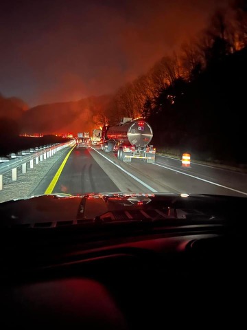
9 hours ago, PowellVolz said:
This was a controlled burn
.Thank you for the update.
-
1
-
-
Not sure if right thread but we know the MS river is very low & dry. Now we have the fire dangers starting. This is near Rockwood off I40 tonight.
-
1
-
 1
1
-
-
Next weekend looks quite January ish temp wise. Then following week rain with highs in low 50’s here in mid state. Enjoy this next week. That’s the forecast now.
-
The wx temp wise has been perfect. Only thing wrong is only a little over half inch of rain since Sept. 1st here. That is trouble leading into the season of leaves falling. Add in the much lower humidity with cooler temps. From wet to dry just like shutting off a valve.
-
2
-
-
It’s getting extremely dry going into a season of leaves falling.
-
Unfortunately the worse flash flooding I have seen in this area in a long long long time. Trees down & many houses around us have water in their homes now.
Update. Rain has stopped but recorded by neighbors close to 7” of rain. Cars were stalled in front of our neighborhood. Pools are overflowing & drains being pulled to help let out water. Crawl spaces flooded in lower part of our neighborhood. Snakes are being seen everywhere where flood waters have brought them in.
-
2
-
-
10 hours ago, nrgjeff said:
My yard gets tough love starting in July. About July 4 I declare my independence from watering, lol!
Lawn was pretty tired before rain last week. Getting there again, but it should rain today. By now it's learned to root deep or suffer. Tough love wins in the long run.
Also good to see some posts. Thought everyone died of heat stroke.
With the coming days & weeks. Heat strokes could be very possible. I’m not looking forward o working outside in this heat.
-
1
-
-
It’s either feast or famine with these pop up storms. It’s going to take a tropical system of at least a couple days of rain to help with the drought conditions in west TN & creeping eastward. The heat coming this week is going to dry the ground out very quickly. What a long miserable hot summer it has been so far. Memphis knocking down 100+ days quickly while here in mid state were knocking down mid 90’s quickly. Dog days of summer usually are in august. Seems this whole summer has been dog days.
-
2
-
-
2 hours ago, John1122 said:
More epic rain fall this evening. Quite a light show as well. No hail but some strong winds here.
It has been a show here with wind added in but no hail. Easily 2-3”. Has been lighting now for 5 hours constant.
-
2
-
-
On 7/5/2022 at 8:32 PM, Met1985 said:
Long range into the SE looks great for us. Looks like a decent trough may come through 3rd week this month.
LR is not to be trusted. It’s been wrong the majority of times. Plus even with cooler near seasonal temps. No rain is setting up crops to be a huge bust & fire dangers increasing. Just not a pretty picture if things don’t change very soon.
-
On 7/1/2022 at 4:00 PM, Carvers Gap said:
Keep that heat on the GFS in Texas!!! If that comes eastward, we are gonna bake. Wowza at the 12z. They are almost out of colors.
Looks like the heat is trying to be in this area for a few days this coming week. I will be at beach so hoping no rain & a clean blue ocean.
-
Here we have had a solid 2-3” in last week including yesterday. My yard is coming back nicely. I have been mowing it higher which made it thicker. So held up much better to the drought & heat so far.
December 2022 Medium/Long Range Pattern Discussion Thread
in Tennessee Valley
Posted
I would think some pretty high ratios also. That’s some ridiculously cold air rushing in.